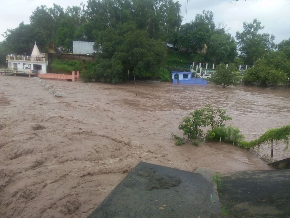
During Sept 4-6, 2014 Jammu and Kashmir in North India is facing one of the worst floods. NDTV[1] has reported that these are the worst floods in 60 years (The Times of India reported that this was worst flood of the state since independence based on number of casualties.). More than 160 people have died and some 2500 villages are affected (1615 in the valley, rest in Jammu), out of which 450 are completely submerged (390 in valley)[2]. Over 10 000 people are stranded across the state. The flood has affected almost all 10 districts in the Jammu region. J&K Chief Minister admitted that the rescuers have yet to reach the worst affected South Kashmir region. Jammu Srinagar Highway has remained blocked for over three days. Several rivers have been flowing above the danger mark and most parts of south Kashmir, including Pulwama, Anantnag and Kulgam districts have been submerged. Jhelum was flowing at 30.7 ft in South Kashmir, 7 ft above the danger mark. Chenab river was also flowing above the danger mark at several places.

Unprecedented floods Landslides triggered by heavy rainfall have damaged roads, dozens of bridges, buildings and crops. As many as 40 people went missing after a landslide in Thanamandi area of Rajouri district in Jammu region. Heavy rain in the catchment areas of Jhelum river has so far submerged more than 100 villages in the south Kashmir districts of Anantnag, Kulgam, Shopian, Pulwama, where the river was still rising, as well as the north Kashmir districts of Ganderbal, Srinagar and Badgam[3]. The flood has surpassed the 1992 memories and revived the 1959 flood memories[4].

Vehicular traffic has been stopped on the Jammu-Pathankot highway due to incessant rain. Jammu is on red alert and Tawi bridge is also in danger.

State Finance Minister Abdul Rahim Rather said Chenab was flowing at 38 ft at Akhnoor which is four ft above the danger mark cumulatively discharging 2.75 lakh cusecs, a quantum of discharge which equals all other rivers of the state.
The situation is very grim indeed: “According to the Army, the situation in the state is as grim as it was in Uttarakhand last year.” Union Home Minister has visited the state and the prime minister has expressed grief.
VERY HEAVY Rainfall during Sept 3-6 The state received massive 250 mm of rainfall in just three days between Sept 3-4, out of its seasonal monsoon rainfall of 568 mm till Sept 6, 2014. Rainfall just on Sept 6 was 106 mm, which is unbelievable 3116% of the normal rainfall for that date for J&K.

It can be seen from the season rainfall map see above of India Meteorology Department as on Sept 6, 2014 that J&K had received 558 mm rainfall till that date, progressing to Excess Rainfall category (blue colour code) from Deficit season rainfall of 308 mm as on Sept 3, 2014 (see IMD map below), in just three days.

CWC has no flood forecasts for J&K However, shockingly, India’s premier water resources body, Central Water Commission, responsible for flood forecasting and providing advisory to the states for tackling floods, has no flood forecast for any place in the state. The CWC’s flood forecast list[5] on Sept 6, 2014 has 18 level forecasts and 8 inflow forecasts, but NONE from J&K. CWC’s Flood forecast site has another option[6] that provides hydrographs for various rivers and location. Again for J&K it provides NO hydrographs. The options on CWC’s Flood Forecast site for list based selection[7] and map based selection[8] again has no information about Jammu & Kashmir.

This seems like shocking omission on the part of CWC, which functions under Union Ministry of Water Resources and reminds one that CWC completely failed to provide any flood forecast when Uttarakhand faced its worst floods in June 2013[9]. We hope CWC will urgently include the flood vulnerable sites of J&K in its flood forecasting and also explain to the people of J&K and rest of the country why these sites were not included so far.

Mismanaged hydro projects increase the damage In this context, media has reported[10] that Dulhasti Hydropower project on Chenab river decided to open its flood gates DURING the worst flood period, which lead to further increase in flood levels in the downstream areas: “Release of water by NHPC dam is expected to increase the levels of the Chenab massively between Kishtwar and Ramban. Surged level can lead to submergence of the highway.” Such additional floods could have been avoided if the gates were kept opened in anticipation of floods. Such opening of gates during the floods can lead to catastrophic consequences for the downstream areas as happened in case of Srinagar Hydropower project in Uttarakhand in June 2013.

MoEF’s wrong decisions The Union Ministry of Environment and Forests have been clearing hydropower projects in the Chenab basin even without proper social and environment impact assessment as was evident in case of Sach Khas project most recently. As SANDRP pointed out in a submission to the Expert Appraisal Committee[11], the EIA and public hearing process of the Sach Khas HEP has been fundamentally inadequate and flawed and yet without even acknowledging the issues raised in this submission the EAC has recommended approval of the project. This is bound to be legally untenable decision. Such decisions by the EAC and MoEF are likely to add to the disaster potential in Chanab and other basins in J&K. There is also no cumulative impact assessment of such massive number of big hydropower projects any basins of J&K.
It is well known, as witnessed in case of Uttarakhand in 2013, that hydropower projects hugely add to the disaster potential of the vulnerable areas. We hope the J&K and central governments make this assessment on urgent basis and we hope the apex court does not have to intervene for such assessment as the Supreme Court had to do through its order of Aug 13, 2013 in case of Uttarakhand.
SANDRP
POST SCRIPT: This is one possible fall out of this, also flashed by several newspaper and following CWC questioned by media: http://www.cwc.nic.in/main/webpages/Flood%20Forecasting%20in%20uncovered%20Himalayan%20and%20interstate%20inflow%20forecasting%2011092014.pdf
Stumbled upon this on January 14, 2015. Hope the government will be now implementing this.
END NOTES:
[1] http://www.ndtv.com/article/cheat-sheet/over-100-dead-as-jammu-and-kashmir-witnesses-worst-floods-in-50-years-587572?pfrom=home-lateststories
[2] http://www.thekashmirwalla.com/2014/09/death-toll-160-jammu-kashmir-facing-worst-flood-60-years/
[3] http://www.kashmirdispatch.com/headlines/050926328-thousands-flee-homes-in-flood-ravaged-jammu-and-kashmir.htm
[4] For pictures of what people are going through, see: http://www.thekashmirwalla.com/2014/09/pictures-deadly-floods-hit-kashmir/
[5] http://180.92.171.80/ffs/current-flood-forecast/
[6] http://180.92.171.80/ffs/hydrograph/
[7] http://180.92.171.80/ffs/data-flow-list-based/
[8] http://www.india-water.gov.in/eSWIS-MapViewer/
[9] https://sandrp.wordpress.com/2013/06/25/central-water-commissions-flood-forecasting-pathetic-performance-in-uttarkhand-disaster/
[10] http://www.kashmirlife.net/kashmir-flooded-chenab-may-witness-upsurge-as-dulhasti-gates-being-opened-65126/
[11] https://sandrp.wordpress.com/2014/08/19/sach-khas-hydro-project-in-chenab-basin-another-example-of-wapcoss-shoddy-eia/
[12] http://www.hindustantimes.com/india-news/flood-situation-in-jammu-worsens-toll-mounts-to-100/article1-1260718.aspx

Expect the entire North Indian plains to be non arable in 20 years if India dependence on crops that demand water. Demographic shifts are been witnessed never before in history with One Billion people unsure when and what to plant to feed her people.
LikeLike
Excellent analysis and recommendations.
Authorities would be blind not to heed to such sensible analysis and at least work to prevent such happenings in future. Clearly what was June 2013 for UKD is Sep 2014 for J&K and these events are going to increase both because of climate change impacts as well as mindless construction of HEPs in the fragile Himalayan belt.
manoj misra
LikeLike
Whether it is Uttaranchal or J & K or in AP – Telangana there is complete failure of disaster management. Indian officials work only when there is money involved to pocket.
For J & K orfor that matter of fact to Chenab, Ravi & Beas the frequency of occurrence of floods follow the 60-year rainfall cycle. We are now in the above the average cycle part with more frequent floods. This period ends by 2016. For example during the below the average rainfall period (1962-1990) the flood frequency was one in nine years in Chenab river and the same during the above the average period (1990-1998) the flood frequency was one in three years.
We must make the government to see disaster management works otherwise close the departments at state and central levels. It is a wasteful expenditure.
Dr. S. Jeevananda Reddy
LikeLike
Thanks for the informative post, Himanshu. Year after year, a similar extreme weather event takes place in the country, only the location changes. Last year it was Uttarakhand, and this year it is J&K. I was talking to my father, who is born brought up in Akhnoor and studied engineering in Kashmir; he told me that floods in Jammu region are still common, but is is very rare for the Valley to have floods. We really need to understand why it has happened, so that in future such occurrences can be controlled. However, we don’t learn from the past.
Are there any other states for which CWC has no flood forecast?
LikeLike
Unless disasters are managed, it will eat the hard earned developments- the entire infra structure would be destroyed .Particularly,floods necessarily destroy crops. Failure of crops means the farmers will need to live on starvation as most of the farmers do not have any alternative means to buy foods till the new harvesting season. In fact, farmers are mostly vulnerable to floods.The country has found the government in affective in handling the disasters that occurred in India during the last 67 years. It is high time to think and act in positive way .
LikeLike