To
Sushri Uma Bharati
The Honourable Minister
Ministry of Water Resources, River Development and Ganga Rejuvenation
Government of India
New Delhi
minister-mowr@nic.in, psmwr-mowr@nic.in, mod-mowr@nic.in, secy-mowr@nic.in, mwp@nic.in
Copy to:
1. Shri Santosh Kumar Gangwar, Minister of State for Water Resources, River Development and Ganga Rejuvenation
2. Shri Alok Rawat, Secretary, Ministry of Water Resources, River Development and Ganga Rejuvenation and ex-officio Chairman of the Narmada Control Authority
3. Shri A. Mahendran, Executive Member (Additional Charge), Narmada Control Authority
Respected Madam,
We the undersigned are deeply concerned about the recent decision of the Narmada Control Authority (NCA) to raise the height of the Sardar Sarovar dam by 16.76 metres taking the height to the designed final height of 138.68 metres.
We think this decision of the NCA is unjustified and unwise. 1) It will cause huge additional displacement, when rehabilitation of the people affected even at the current height is incomplete. 2) As everybody agrees and experience has shown, even at current height, Gujarat is in a position to take the water stored to virtually any part of the designed command area, and can draw its share of water as per the Narmada Water Disputes Tribunal (NWDT) award. Moreover, it has been able to utilise only a small portion of the water available at current height. So there are no compelling reasons for raising the height on this count.
Under these circumstances, the decision taken by the newly formed government at the centre and the NCA to raise the height of the dam within two weeks of oath by the new government is a hasty, unwise and disastrous decision. We earnestly appeal to you and the government to immediately withdraw the decision to raise the height of the dam.
More importantly, the issues related to the dam have festered over more than 30 years of its troubled history because governments have tended to take a legalistic stand rather than initiate an inclusive dialogue on the substantive issues about the project amongst all concerned, particularly those adversely affected. We appeal to you to start such an inclusive process of reflection and dialogue to arrive at a broad social consensus on four critical issues about the Sardar Sarovar Project (SSP) as outlined below.
1. Height of the dam: What is the height of dam needed for Gujarat to utilise its share of Narmada waters and take water to all its designated command? As already mentioned above, Gujarat is in a position to take water anywhere in the designated command area. There are studies and alternatives which indicate that Gujarat may be able to utilise its share of Narmada waters at current height and no further height increase may be required on this count. Doing away with the installation of the 16.8 meter high gates does not have any structural implications for the dam. So far as power generation is concerned, major power benefit is transitional, falling off as the states utilise their share of water and final residual power benefit is small. Moreover, even today, as per Central Electricity Authority (CEA) figures, at current height SSP generated 5,882 Million Units of Power in 2013-14, which is more than what SSP was envisaged to generate. The biggest beneficiary of power generated at SSP is Madhya Pradesh, but it forms a small percentage of its present power capacity and generation while virtually the entire brunt of massive displacement has to be borne by it. So, it may be optimal for Madhya Pradesh to trade off much of its transitional power benefit with the greatly reduced submergence and displacement with a dam at the current height. Thus there is a distinct possibility that optimal solutions exist at current height and they need to be explored.
2. Equitable distribution, sustainable use and participatory and efficient management of stored water: Given the ability to carry water to all parts of Gujarat at current height, it is more important to concentrate on issues of how water is used now. Criticism on these counts comes from some of the strongest proponents of the project. The project has been criticised, among other things, on account of gross underutilisation of the stored water, irrigation water not reaching the drought prone areas of Kachch, Saurashtra and North Gujarat, diversion of water for unplanned uses (for example, river front development, urban and industrial use south of Sabarmati), non existence of water users’ associations (WUAs) for most part of the command, lack of proper drainage in the command area, and inefficient and inequitable use.
3. Status of displacement and rehabilitation: There is a large gap in the perceptions and articulations of state and various groups and individuals including those from the adversely affected, both about the exact numbers involved as well as about the quality of rehabilitation. While the authorities have generally been claiming satisfactory rehabilitation, there is every indication that the rehabilitation even at current height falls quite short of what is legally required or what basic human justice demands. Since the submergence and displacement that would take place between 121.92 metres and 138.68 metres would be massive, there is every indication that effective rehabilitation would be intractable and virtually impossible. It becomes much more urgent to bridge this gap and come to a consensus on the actual extent and quality of rehabilitation already carried out before causing further massive displacement.
4. Environment and Climate Change: Environment and climate change issues that are important in the long run have not been given due attention. Downstream impacts of SSP on environment and livelihoods have not been properly assessed, environment-flows and requirements have not been studied and management plans have not been formulated or implemented. Climate change experts emphasise the importance to reevaluating the costs, benefits, impacts and optimality of projects and it is high time we initiated studies and discussion on these with respect to the SSP. If rejuvenation of rivers is to receive a central place in water resources development and the Narmada is to remain alive these issues need to be brought into discussion and resolved as soon as possible.
Good governance entails making socially and environmentally just decisions within a deliberative democratic framework and it is the lack of this that has resulted in three decades history of conflict and polarisation around SSP. We sincerely hope you will put us on a path of better governance, the professed aim of the new government, by revoking the decision to increase the height of the SSP from the current 121.92 m to 138.68 m and initiating a comprehensive dialogue on the substantive issues surrounding it.
Yours sincerely,
A. C. Bhagabati,
A. Latha,
A. Vaidyanathan,
Achyut Das,
Amita Baviskar,
Ashish Kothari,
Bharat Patankar,
Brij Gopal,
Devaki Jain,
Dinesh Abrol,
Dunu Roy,
Ghanshyam Shah,
Himanshu Thakkar,
Himanshu Upadhyaya,
K. J. Joy,
Kanchan Chopra,
M K Prasad,
Mamata Dash,
Manoj Mishra,
N. C. Narayanan,
Nafisa Bharot,
Prashant Bhushan,
Rajeswari Sarala Raina,
Ramaswamy R. Iyer,
S. Janakarajan,
Sanjay Kak,
Seema Kulkarni,
Sharachchandra Lele,
Shripad Dharmadhikary,
Sudarshan Iyengar,
Sudhirendar Sharma,
Suhas Paranjape,
Vimalbhai,
Viren Lobo.
Names added subsequently:
Persis Ginwalla,
Rohit Prajapati
V N Sharma
For any further details and follow up please contact:
Ashish Kothari (chikikothari@gmail.com);
Himanshu Thakkar, (ht.sandrp@gmail.com);
Himanshu Upadhyaya (himanshugreen@gmail.com);
K. J. Joy (joykjjoy2@gmail.com);
Shripad Dharmadhkari (manthan.shripad@gmail.com);
Suhas Paranjape (suhas.paranjape@gmail.com)
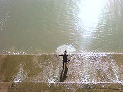
Above: Hilsa fishers in Bangladesh setting out for their journey Photo: with thanks from Arati Kumar-Rao
In addition to the Gangetic Fisheries Primer, SANDRP will shortly publish a Primer documenting the Impacts of dams on Riverine Fish and Fisher Communities. One of the most profound impacts of dams on fish is blocking migration routes and perhaps no other fish symbolizes this impact as dramatically as the Hilsa: the Silver Queen of the River.
Glimpses of the impacts of dams on Hilsa in South Asia.
Arguably, Hilsa is not just a tasty and healthy fish species that migrates from the sea up the river to spawn. It is a cultural icon that binds Bengalis, whether from West Bengal or Bangladesh, together in their shared love for Ilish Machch. Pohela Baishakh or the new year day’s meal is not complete without Ilish. Though Hilsa is celebrated fervently by the Bengalis, it is prized in all estuaries of South Asia, from Narmada, Mahanadi, Godavari, Cauvery to Indus and Irrawaddy and takes the name of Chaski, Palva, Ilishii, Palla, Pulasa, etc. It is also found at confluence of Tigris and Euprates in Iran, where it is as prized and known as Sbour. The fish flavours several poems, folklore, songs and phraseologies of the entire South Asia. In cultural terms, the significance of Hilsa is comparable only to Salmon and Mahseer.
Ilish fish and rice, a religious offering and cultural fare on Pohela Baishakh Photo: Flickr
Tenualosa ilisha, Hilsa or Indian Shad belongs to the sub family Alosinae of Family Clupeidae. Commercially, it is the most important fisheries in the estuaries, especially in the Ganga-Hooghly region.It occurs in marine, estuarine and riverine environments and is found in Indus of Pakistan, Irrawaddy of Myanmar and Indian rivers like Ganga, Bhagirathi, Hooghly, Rupanarayan, Brahmaputra, Godavari, Narmada, Cauvery, Tapti, coastal rivers like Padma, Jamuna, Meghana, Karnafuly and others in Bangladesh. It is seen to migrate up smaller estuaries like Pennar too.
Hilsa, by habitat, is a marine fish but migrates in estuaries and rivers for spawning, normally inhabiting the lower region of the estuaries and the foreshore areas of the sea. Hilsa ascends the rivers for spawning and the spent fish and their progeny migrate down the river towards lower estuaries and coastal areas, moving in shoals. The peak upstream migration of Hilsa in most of the rivers of the country is generally in the monsoons months of July and August and continues upto October or November. The spring spawners that enter the river for spawning in January-March return to the sea during July-August when these are caught in good numbers. The monsoon spawners that enter the river during September- October return to the sea after spawning and these spent fishes are caught in good numbers during January- March. Similarly, the off springs of spring-spawners make journey for the sea from the river during November- January, whereas the off springs of monsoon spawners return to the sea from the river during July- September. (Bhaumik et al, CIFRI, 2012)
Obstruction to undertaking this spawning migration by dams and barrages has been singled out as the primary reasons for the fall of Hilsa fisheries in India as well as Bangladesh. The trade of this commercially important fish species constitutes upto 1.5% of Bangaldesh’s National Gross Domestic Product and about 2 million fishers are estimated to depend on Hilsa fisheries in Gangetic estuaries. Till August 2014, Bangladesh has stopped Hilsa exports to India to contain astronomic price rises in Bangladesh as the costs of the fish are becoming uncontainable due to its cultural importance on one hand and dwindling supply on the other. India has requested Bangladesh to lift the ban of Hilsa export, but it is yet to relent, due to a number of socio-political reasons. [2]
Fishers setting off for Hilsa from the Bangladesh Sunderbans Photo: With thanks from Arati Kumar-Rao
One of the main reasons for the phenomenal fall of Hilsa in Gangetic delta has been the Farakka Barrage built by India in the 1970’s, just a few kilometers upstream the India –Bangladesh border, to divert water from Ganga into the Hooghly river, to keep the Kolkata Port at the mouth of Hooghly, free of sediments.
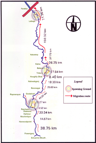
Prior to commissioning Farakka Barrage in 1975, there are records of the Hilsa migrating from Bay of Bengal right upto Agra, Kanpur and Delhi covering a distance of about 1400 kms. Maximum abundance was observed at Buxar, near Allahabad, at a distance of about 650 kms from river mouth. Post Farraka, Hilsa is unheard of in Yamuna in Delhi and its yield has dropped to zero in Allahabad, from 91 kg/km in 1960s. Studies as old as those conducted in mid-seventies[3] single out Farakka’s disastrous impacts on Hilsa, illustrating a near 100% decline of Hilsa above the barrage post construction.
Migration route of Hilsa, Pre Farakka Barrage spanning about 1400 kms Source: CIFRI 2012Highly restricted range of Hilsa post Farakka Source: CIFRI
An obligatory Fish lock provided in Farakka Barrage is non-functional and tagging experiments reveal that Hilsa cannot move across the barrage due to obstruction of three-tire sluice gates.[4] For more on how Farakka has failed its objective and continues to impact livelihoods: https://sandrp.wordpress.com/2014/11/25/lessons-from-farakka-as-we-plan-more-barrages-on-ganga/
Fishers who live off the Ganges strongly feel the pressure of dams, personified by Farakka. In north India, ‘Farakka’ –the word doesn’t mean a village on the Bangladesh border anymore, but means destruction by dams. The local Hindi dialects have borrowed new phraseology: “Farakka hua, tabse hilsa toh bas bhabis” (Farakka happened, and then Hilsa exist only in imagined future)”. The same phrase repeats up to the Yamuna River! In a recent status survey of Gangetic fisheries almost 75-80% of fishers singled out ‘Farakka’ as the root cause of all their miseries. They actually referred to multiple barrages built on the respective rivers. But destruction had a common name: Farakka.[5]
Bangladesh has been making several serious attempts to revive Hilsa fisheries and implements a strict fishing ban in certain months to avoid fishing “jatkas” or small Hilsa. It has also declared several Hilsa Sanctuaries to protect the fish and is witnessing small and steady improvements in the population. India has hardly taken any steps to protect this specie. IUCN has led a program called Ecosystems for Life: A Bangladesh-India Initiative and Hilsa fisheries is a part of this project. There is also a Norwegian project on Hilsa Aquaculture [7] ( All prior efforts of Hilsa Aquaculture have failed). However, the primary need to address the giant problem of the Farakka Barrage is being unaddressed. The barrage and reduced freshwater in the downstream is also exacerbating other stressors like sedimentation of the river mouth, high fishing pressure on limited stocks, concentrated pollution, etc.
Hilsa in other Rivers (would taste as sweet!) Hilsa is found not only in Ganges delta but most of the estuaries in India. In all of these places, Hilsa fishery is primarily affected by dams and barrages near the estuaries, blocking spawning migration and reducing freshwater from upstream.
Hilsa in Cauvery: A century of impacts In Tamizh, Hilsa caught at Sea is Kadal Ullam and the one in the River is the Aattu Ullam. Here, the impact of Mettur dam on valuable Hilsa fisheries in the Cauvery has been recorded as early as 1939 in an issue of Current Science, where it is stated: “Unfortunately the effect of the dam (Mettur on Cauvery) on the fisheries below was disastrous. The number of valuable Indian Shad or Hilsa, the most important sea fish ascending the Cauvery for breeding purposes, declined as the high floods which enabled them to ascend the rive no longer occur. The serious decline of fisheries in Cauvery would be evident from the fact that the fishery rental of the river below the dam which used to amount to 80000 Rs. annually has steadily declined since the formation of the dam to about 42,900 rupees.”[8]Puntius species also disappeared in Cauvery post dam, which formed 28% of the landings prior to dam construction.[9]
As per the Report “Fishing the Cauvery: How Mettur Changed it all,” by Ramya Swayamprakash published by SANDRP[10], It was Sir Aruthur Cotton himself, way back in 1867 who alerted the erstwhile government about the damages wrought by weirs on river fisheries. Immediately, Dr. Francis Day was commissioned to investigate the impact on fisheries and subsequently appointed Inspector-General of Fisheries in India. In his report on the fisheries of India and Burma, Day condemned dams as insurmountable barriers to fish passage; he designed a fish passage which was on the Lower Anicut on the Kollidam. The pass was primarily designed for the Hilsa who could not ascend it, as it was too wide. According to the Madras Fisheries department in 1909, the fish pass did not ensure Hilsa migration because of various practical and technical difficulties; in the first place, the expenses for the construction of a fish pass were not commensurate with the expected results and secondly, sufficient water could not be provided for the efficient working of the pass. Interestingly, Hilsa was sought to be cultivated and exported along the lines of the Salmon in north-western United States. So important was the Hilsa that a stuffed specimen made its way into the exhibits sent to the Great Exhibition from the Bombay Presidency, in 1851!
Fishing at the Lower Anicut on Cauvery Photo: Wikimedia Commons
Today, the Hilsa is unknown on the Cauvery. According to fish biologists, the Hilsa ascended the anicuts on the Cauvery up to Mettur to spawn overcoming the low anicuts. But the coming of the Mettur Dam formed an impassable barrier.
Hilsa in Godavari is known as Pulasa when caught i the river and Vilasa when caught n the sea! Here too, the fish is declining and main reasons are said to be declining water levels and the Dowleswaram Barrage [11] (Arthur Cotton Barrage). In Andhra villages too Pulasa has a huge cultural significance.
This author made a presentation to the Standing Committee of the Lok Sabha, the lower house of Indian Parliament in June 2012 about the impacts of dam on riverine fish and discussed Hilsa, when an MP from Coastal Godavari district in Andhra Pradesh said, “I know Pulasa! My constituency depends on riverine fisheries like Pulasa, and not marine fisheries, but we end up talking only about marine fish and not river fish and Pulasa and the impacts of upstream projects on livelihoods of river fishers”
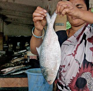
Pulasa/ Hilsa of the Godavari Photo: The Hindu
In Mahanadi, Orissa, Hilsa has been hit by dams and is recording a declining trend[12]. Paradip recorded about 500 tonnes Hilsa, but prices have increased astronomically.[13]
Hilsa in Narmada, Sardar Sarovar and the proposed Bhadbhut Barrage The narrative of damming the Narmada by the Narmada Valley Projects is one of the most significant stories of an on-going struggle against modifying a river and way of life of her people. Although there are many facets to the story ranging from displacement, false benefits and true costs, forest loss, non-existent rehabilitation and an all-pervasive insensitivity of the government towards weaker communities, the impacts of this project on riverine fisheries have been equally profound. Narmada River system experienced a nearly 70% decline in Hilsa catches in just a decade between 1993 to 2004 ( From 15319 t to 4866 t ) and this decline was prominently recorded from 1998-99 onwards.[14] As per CIFRI, the most stressed species after Sardar Sarovar Project (SSP) construction is the Hilsa and Macrobrachium prawn (Jumbo River Prawn). CIFRI made some prediction about impacts of the dam after 35 years, calling it a ‘critical period’ when fisheries will be nearly lost. Shockingly, these conditions are already being witnessed in Narmada Estuary in Bharuch which records nearly 30% Inland Fish production. More than 12,000 people from 21 villages in Bharuch alone depend on Narmada Estuary for fisheries.
Assessment of impact of commissioning of Sardar Sarovar dam and other projects in 2009 by CIFRI revealed that SSP will retain 96% of the sediment, adversely affecting biological productivity of the downstream including Narmada estuary.[17] However, already the Sardar Sarovar and upstream dams in Narmada Basin have already resulted in retention of about 95% sediment, cutting off the delta from nutrient rich silt. Historical sediment discharge of Narmada was 61 million tonnes and the current sediment discharge (average of last ten years of the study) was found to be 3.23 million tonnes.[18]
According to CIFRI, “While the annual inflow is 23.68 MAF (1981-1990), it will be reduced to 15.9 MAF after 10th year of SSP, to 4.34 MAF at the 30th year and will cease at the 45th year. This freshwater decline will severely affect Hilsa fishery and prestigious fishery contributed by M rosenbergii (Jumbo River Prawn)”. As freshwater declines, there will be “Steep hike in salinity regime with tidal ingress. Fishery not tuned to such enhanced salinity will succumb to such pressure. Mangroves will also be affected and this will impact marine fish production as Mangroves are nurseries of many marine fish.”
Gujarat Government has agreed to release 600 cusecs water from Sardar Sarovar and Bhadbhut Barrage as environmental flows. There is no study as to whether this amount is sufficient for estuarine balance, for ecological needs of Hilsa or other species, for spawning migration, etc. Also, there is no guarantee that Gujarat will release this meagre quantity. Ironically, the minimum flows of 600 cusecs agreed to be released by Gujarat through SSP come to 532. 9 Million Cubic Metre (MCM) water annually and CIFRI’s warning of a sharp fisheries decline at 30th year was for 4.34 MAF or 5353.4 MCM! So, 532.9 MCM released now as minimum flows is barely 10% of a dire scenario predicted at 30th year of commissioning SSP[i]!
It is hardly a wonder that Hilsa is falling sharply in Narmada Estuary and fishers are directly blaming the Sardar Sarovar for this decline.[19]
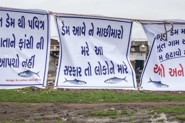
Last Straw for Narmada Hilsa: Bhadbhut Barrage: Gujarat Government is planning to build Bhadbhut Barrage about 17 kms from Bharuch, directly affecting the Narmada estuary and the Hilsa and Prawn fishery. The Barrage is planned for SEZ and also water sports and is a part of an infeasible scheme known as the Kalpasar project which plans to dam almost all rivers as they meet the Gulf of Khambat.
Slogans against Bhadbhut Barrage say: “The Dam will kill the fishers: This government is killing people”
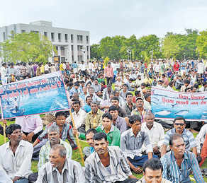
The Bhadbhut Barrage is being fiercely opposed by fishers in Bharuch because of its serious impacts on their livelihoods and Hilsa fisheries. Public Hearing of Bhadbhut Barrage was held in July 2013, wherein the fisher community staged a walk out, stressing that the EIA had under-reported Hilsa fisheries in the region, number of fishers and their dependence on the Estuary for fish. The walkout took place immediately after Pravin Tandel, the fisherfolks’ local leader, spoke saying the project would “adversely affect the fish catch, especially Hilsa, once it is implemented. Currently, Hisla fetches Rs 1,200 per kg, and is our main source of livelihood.”[20]
Fisherfolk protesting against Bhadbhut Barrage Photo: Counterview.org
Hilsa in the Indus: In the Indus too, Hilsa fisheries, known as Palla are the main stay of local fisher communities. Hilsa fish is a highly contested territory due to declining catches.
Before the construction of the Sukkur Barrage, the Palla used to reach to Multan as per records of 1907. The Sukkur Barrage and then later the Kotri Barrage severely restricted Palla’s range, affecting the fish and its fishers. According to M. R. Quereshi, ex-Director of Marine Fisheries Department of Pakistan, the Palla used to ascend the river (Indus) to spawn in the middle of June but its ascent is now delayed by at least one month owing to late freshets. Kotri Barrage near Hyderabad has severely restricted its breeding range. Like the Cauvery, in Kotri too the fish ladders do not work due to faulty designs and Hilsa is unable to ascend them, consequently prevented from going up to the upper reaches of the river. As a result the Hilsa fishery is being depleted and immediate action is imperative to increase its production. “Failing this, the fish will eventually disappear from the river.”
Palla/Hilsa fishers at Kotri, on the banks of Indus circa 1890. Photo from British Library, UK
To conclude, the fate of this silvery fish hangs in a fine balance. Not only does the Hilsa enjoy huge cultural significance, it also supports millions of livelihoods. In the United States, several dams, like the recent Glines Canyon Dam on the Elwha, have been decommissioned for their impacts on migrating fish and dependent communities. Elwha river dams came down in a biggest decommissioning effort because the indigenous Klallam tribe asserted its rights on traditional Salmon fisheries which were blocked by these dams. In Japan too, Arase Dam was decommissioned because of its impact on Ayu fish and fishers.
What has happened in India to the Hilsa fish and fishers is far more serious.
Hilsa has a striking ecological, economic and cultural significance. Till date, ranching or farming of Hilsa has not worked. Till date, fisher communities continue to face conflicts, hardships and risks, go deeper and deeper in the sea to gather a few Hilsa. Till date, dam operations have not changed, nor have the fish passes been designed, built, operated or monitored to help the fish. Till date, none of the fisher communities who suffered colossal losses when a dam affected Hilsa, have been compensated for their loss.
Is it not time to rethink these dams, to help the fish and our fishers?
Hilsa as a sacred offering Photo from Flickr, with thanks to Arup Kanjilal
[1] Dugan, 2008, Quoted in FAO Report No. 7, Sustainable Fisheries and Aquaculture for food security and nutrition, 2014
[2] Chief Minister Mamata Banerjee refused to share the Teesta waters with Bangladesh, the neighbouring country has imposed a ban on export of the silver-scaled fish.
[3] Ghosh, 1976 quoted in Review of the biology and fisheries of Hilsa, Upper Bengal Estuary, FAO, 1985
[4] Bhaumik and Sharma, Present status of Hilsa in the Hooghly Bhagirathi River, CIFRI, 2012
[14] Milton, STATUS OF HILSA (Tenualosa ilisha) MANAGEMENT IN THE BAY OF BENGAL: AN ASSESSMENT OF POPULATION RISK AND DATA GAPS FOR MORE EFFECTIVE REGIONAL MANAGEMENT, Report to FAO Bay of Bengal Large Marine Ecosystem Project , 15 February 2010
[15] CIFRI, River Narmada, Its Environment and Fisheries, 2009
[i] While we do not know the schedule through which Gujarat Government plans to release this water, the fact remains that this figure of 600 cusecs is not supported by any studies.