Why is Tehri filled up with half the monsoon still to come?
The Tehri dam reservoir on Bhagirathi river in Uttarkashi district in Uttarakhand is filled upto 818.4 m as on August 5, 2013, as per the latest available information on Northern Region Load dispatch Centre (http://nrldc.org/). With permitted full reservoir level of 820 m[1], the FRL is just 1.6 m above current level. At current rate, the water level in the Tehri dam may reach FRL in less than a week. The question is why is Tehri dam being filled up when almost half the monsoon is still to come? And when going by the trend so far, the monsoon is likely to continue to bring surplus rains? Now the Tehri dam is posing a huge, grave and real risk for the downstream areas in Uttarakhand and UP as the monsoon rains continue in all its fury.
In last 35 days since July 1 (level 780.05 m), the water level in the dam has gone up by 38.35 m. In last four days since Aug 1, the level has gone up by 7.85 m. On every single day since July 1, Tehri has been releasing less water than it has been receiving, which means the dam is hoarding water (a detailed list of reservoir level, inflow and usage at Tehri dam from July 1 to August 6 is given in the annexure below). On at least 22 days since July 1, the dam has used less than the optimum quantity of water it can use, that is 572 cubic meters/ sec. The Tehri dam generated 657.65 million units of power during July 2013, which is below the optimum it can generate (744 MU) and also less than what it generated for example in Aug 2011 and Sept 2010. As a direct consequence, while less power was generated, more water was accumulated behind the dam and now the dam is posing a risk to the downstream areas.
Safety issues at Koteshwar Dam: Vigilance enquiry on It may be recalled that in September 2010 similar mismanagement at the Tehri dam led to huge and avoidable floods (for details see page 20 of Aug Sept 2010 issue of Dams, Rivers & People: https://sandrp.in/drp/DRP_Aug_Sept_2010.pdf) in the downstream Uttarakhand and UP. Thus the highest ever flood level of 296.3 m at Haridwar was reached on Sept 19, 2010 (see http://www.india-water.com/ffs/static_info.asp?Id=24). In fact in Sept 2010, the downstream Koteshwar dam of THDC also suffered severe damages due to this mismanagement and now it is unable to take larger flows from upstream Tehri dam. The weak civil works of Koteshwar dam is also now facing vigilance enquiry as per the Aug 4, 2013 report from http://www.energylineindia.com/. The report said, “Vigilance department had expressed its concerns regarding the civil works and works relating to diversion plug, which are extremely susceptible to rains and are vulnerable to lead to major impact on the dam safety… The stalemate at THDC’s 400 MW Koteshwar Dam and Power House (KDPH) has seen work come to a halt in the event of non completion of emergency works for the project.”
97.5 m high Koteshwar Dam is located 20 km downstream of Tehri dam (photo: hydroworld.com)
AIPEF misleading Power Ministry? It is reported[2] that All India Power Engineers Federation has written to the Union Power Ministry, expressing concern that spillage from Tehri dam will pose risk of flooding of the downstream Koteshwar project. This concern also seems to suggest that Koteshwar dam is not strong enough to take the higher water releases from Tehri that may be required. The Matu Jansangthan[3] has also raised concern about safety of the Koteshwar dam and its impacts. The request in the letter that THDC be allowed to increase the water storage to 830 m is anyway misleading since it is not in the hands of Power Ministry.
Uttarakhand waiting for new disaster? It seems from this situation that unless urgent steps are taken, Uttarakhand may be in for a new disaster pretty soon. It is strange that while this situation was developing over the last month a number of agencies that should have taken advance notice and action have been sitting quietly.
Þ Central Water CommissionIndia’s highest technical body on water resources is supposed to provide rule curve for safe operation of all dams. It seems CWC has not issued any such safe rule curve for Tehri or the rule curve issued by it is unsafe like it is in many other dams.
Þ Uttarakhand and Uttar Pradesh government In case of the flood disaster that will happen in the downstream area because of the wrong operation of the Tehri dam, it is the people, lands, property and environment of the Uttarakhand and Uttar Pradesh governments that will be affected. But Uttarakhand or the Uttar Pradesh seems to have taken no action. Uttar Pradesh government is also partner with THDC in the project.
Þ National Disaster Management Authority NDMA should be concerned about this impending manmade disaster and should have taken action, but seems to have done nothing.
Þ Union Ministry of Water Resources The Ministry is supposed to be concerned about the safety of all dams in India, but has clearly failed to do anything about Tehri or Koteshwar.
THDC, Uttarakhand Chief Minister, Central Water Commission among others have been making a lot of false claims about Tehri dam having saved Uttarakhand during the Uttarakhand flood disaster during June 15-17, 2013. Our analysis[4] showed that this is clearly false claim and also warned that Tehri could turn out to be a source of disaster in the remaining part of current monsoon. That situation now has clearly developed and requires urgent intervention. We hope all concerned authorities will urgently intervene and ensure that no such disaster happens.
[1] In ongoing Supreme Court case, THDC does not have permission to take water level behind the dam above 820 m due to lack of progress in rehabilitation. On Aug 27, 2010, THDC was given a one time temporary permission to take water level to 830 m only as an “emergency measure”. Now THDC is seeking SC permission to take the water level to 835 m from the current permissible 820 m, but that is unlikely to be agreed by the Uttarakhand government considering the state of rehabilitation. The case is likely to come up before the Supreme Court in Sept 2013, as per Matu Jansangthan, which is fighting the case.
Reservoir level, inflow and usage (outflow) at Tehri dam during July 1, 2013 to Aug 6, 2013
Date
Reservoir Level (meter)
Inflow (cumecs)
Usage (cumecs)
01-07-2013
780.05
603.78
462
02-07-2013
780.05
603.78
462
03-07-2013
781.1
554.73
540
04-07-2013
781.1
599.4
538
05-07-2013
781.6
545.81
536
06-07-2013
781.9
680.47
537
07-07-2013
781.9
680.47
537
08-07-2013
781.9
680.47
537
09-07-2013
781.9
680.47
537
10-07-2013
786.6
760.77
540
11-07-2013
787.1
785.2
645
12-07-2013
787.45
633.13
546
13-07-2013
788.45
804.66
546
14-07-2013
NA
749
549
15-07-2013
790.1
798.15
551
16-07-2013
790.1
798.15
551
17-07-2013
790.1
798.15
551
18-07-2013
793.8
910.51
546
19-07-2013
793.8
910.51
546
20-07-2013
796.35
855
475
21-07-2013
799.3
855
236
22-07-2013
800
810.53
459
23-07-2013
802.3
917
541
24-07-2013
802.3
917
541
25-07-2013
804.15
946.5
574
26-07-2013
808.5
1471.92
572
27-07-2013
809.7
972.44
564
28-07-2013
810.50
792.25
569
29-07-2013
810.50
792.25
569
30-07-2013
810.50
792.25
569
31-07-2013
810.50
792.25
569
01-08-2013
810.50
792.25
569
02-08-2013
810.55
730.41
572
03-08-2013
814.70
629.43
573
04-08-2013
816.15
617.8
572
05-08-2013
817.15
NA
NA
06-08-2013
818.4
NA
566
Effective Full Reservoir Level of THDC – 820 meter, NA – Not Available. The dates mentioned here are reporting dates, the levels and flow figures are for the previous day. Source: http://nrldc.org/
“At the ground level people are really interested and they want to get involved and our report if nothing else, seem to have serve the purpose of triggering such kind of an interest” said Prof. Madhav Gadgil who delivered a lecture on “Democracy and ecology in contemporary India” at the Nehru Memorial Museum and Library (NMML) on 17th July 2013. His lecture was part of the public lecture series on ‘Science Society and Nature’ and the event was attended by more than 400 people, the second highest audience NMML has witnessed for public lecture as Director Mahesh Rangarajan revealed at the end of the lecture. The lecture was chaired by Jairam Ramesh, the former Minister of Environment and Forests and currently the minister for Rural Development and also in charge of Ministry of Drinking Water and Sanitation.
Prof. Gadgil in his lecture presented several case studies through which he showed how in the name of ‘development’ only lip service has been paid to the environmental norms and all democratic processes have been sidelined. Dr. Gadgil also shared his experiences of working for the Western Ghats Ecology Expert Panel (the report submitted by this panel can be accessed here – http://moef.nic.in/downloads/public-information/wg-23052012.pdf) which was formed by the Ministry of Environment and Forests (MoEF) to study the ecological and environmental concerns of the Western Ghats under his aegis.
Talking about iron mining in Goa, Prof Gadgil said the government of Goa even does not have any account of how much ore has been extracted by the mining contractors, leaving aside environmental concerns. Bringing the issue of unprecedented dam construction in Western Ghats, he gave the example of Athirappilly dam in ChalakudyRiver in Kerela which was the eight dam proposed in the river. There was a clear violation of Forest Rights Act, as construction of this dam would lead to displacement and subsequent extinction of the ‘primitive tribal’ community named Kadar. The government officials were claiming that if this dam was not constructed Kerela would starve for electricity. But a detailed presentation by RiverResearchCenter, Kerela covering technical, economic and social aspects of the proposed dam showed this dam was not viable as there would be not be sufficient water left in the river for this dam as the water would already be harnessed in the seven upstream dams. The government officials, who were claiming that Kerela would go power hungry, had no reply to this.
Presenting the case of Plachimada village in Perumatti Panchayat in Palakkad district of same state, he said that Coca Cola Company had not paid any compensation that it was supposed to pay to the farmers of Plachimada as ordered by the Supreme Court. Coca Cola was also supposed to pay a tax of Rs 60 cores to the government of Kerela but the government had surprisingly given tax exemption of Rs 6 crores to the company. In both these examples he showed how the acts of democratically elected government were actually against people and environment. But he hailed the Plachimada struggle against Coca Cola as a ray of hope since this was a struggle led by a Panchayat, a local level democratic institution which brought a multi-national company to its knees. He also pointed out how law and order mechanism of state had been used to suppress people’s protests against illegal pollution in Lotte, in Ratnagiri district of Maharashtra.
Throughout his lecture Dr. Gadgil strongly argued for decentralization of power in order to protect ecology and environment. He mentioned about the powers given in the hands of the local bodies through the 73rd and 74th amendment of the constitution of India. He said that there are several laws and policies e.g. Bio-logical Diversity Act (2002), National Gene Funds which talked about participation of citizens in the decision making but this was never implemented on the ground. He said that the Environmental Impact Assessment (EIA) documents and the whole environmental clearance process should be reconsidered and reviewed (a press release on the functioning of Expert Appraisal Committee which grants environment clearance termed the committee as Expert Approval Committee – https://sandrp.wordpress.com/2013/02/05/analysis-of-moefs-eac-on-river-valley-projects-the-expert-approval-committee-has-zero-rejection-in-six-years/).
Taking the case of mining in Goa, he said that his team of the Ecology Expert Panel reviewed EIA documents of 75 mines and found that all the mines had made fraudulent statements about how the mines would impact the rivers and rivulets. There were EIA documents of these mines which even denied the existence of perennial streams in the hill plateau where these mines existed. In one case when he wrote to one of the mine managers about the existence of a famous stream near that mine, but the reply was that since there were no blue lines in the geological map of Goa, there are no streams.
He stressed on the need to engage local people in the decision making process and increase dissemination of information. He took the example of ‘Australian River Watch’ programme where the citizens are trained to monitor the health of a river just by looking at the bio-logical indicators. He opined that India should take lessons from this and should initiate such programmes. He said that in our democracy we have many possibilities of engaging in decision making. He ended his speech by saying that for India to progress, India should take bottom up approach and strengthen its democracy, rule of law, scientific temperament and traditional ecological knowledge.
Q&A session brought out more issues – The question-answer session which followed the lecture also brought several important issues in to the foray. Answering a question about how much scientific peoples’ knowledge is, he said that one must understand that peoples’ knowledge is historical and locality specific and traditional. So the people of a certain locality would know better about the ecology and environment of a specific place rather than experts or engineers. Here again he emphasized on the need to include of common people in the decision making process.
Answering a question about the climate change impacts in the Western Ghats, he said that there are no immediately visible impacts of climate change in Western Ghats. But he said that Himalayan range already had visible impacts of climate change in the form of glacier melting and increased precipitation. But he warned that Western Ghats will surely have climate change impacts in the future.
When asked about his opinion on the future of Western Ghats if the diluted version of his report, i.e. Report of the High Level Working Group headed by Dr Kasturirangan (A blog that compares Kasturirangan and Gadgil Panel report can be found here – https://sandrp.wordpress.com/2013/04/24/how-much-does-the-kasturirangan-committee-understand-about-water-issues-in-western-ghats/) gets accepted by the government, Dr. Gadgil laughingly said that he knew that his report would not be accepted but he was sure that Kasturirangan’s report would also not be implemented (A letter by Prof Gadgil on Kasturirangan committee can be found here: https://sandrp.wordpress.com/2013/05/18/prof-madhav-gadgil-writes-to-dr-kasturirangan/). But he expressed his surprise on the fact that after his report, people are really awakened and they are now paying attention to these issues. He is happy to see that at the people in the ground level are really interested to know about the environmental issues. He said that the report by his group, had served the purpose of triggering this interest if not anything else. He expressed his optimism about the report. (SANDRP comment on Kasturirangan Committee submitted to MoEF can be found at: https://sandrp.wordpress.com/2013/05/20/comments-on-hlwg-report-submitted-to-ministry-of-environment-and-forests/)
Talking about gender imbalance he narrated an experience of 1984 of a Zila Parishad in Uttar Kannada district in Karnataka. There he organized a meeting of all the Zila Parishad members to know their views on environmental issues in their zila (district). In that meeting it was mainly the women members who vociferously talked about the environmental concerns and they gave excellent feedback on the issue. He added that from his experience of working on such issues all these years, he has found that in the local elected bodies it is the women members who are more concerned with environmental issues.
Answering a question regarding dam construction in northeast he said that very less knowledge is available about the geology of young HimalayanMountain. Giving the example of the recent Uttarakhand disaster he said that one of renowned environmentalist from the state, Dr. K. S. Valdiya have been completely ignored and was never consulted for any of the developmental activity in the state even though he has written extensively about the geology of the hilly state. This is actually ignoring scientific knowledge about the area and he expressed his fear that similar things might be happening in the northeast as well.
Answering a question about recent flood devastation in Uttarakhand, he said that from Dr. K. S. Valdiya what he had come to know is that lawless and a mindless construction activity like dhabas and hotels, in the river bed of Mandakini in Uttarakhand is one of the major reasons for the increased amount of devastation in the recent flood. He said that traditionally the people of Uttarakhand used to construct houses far from the river in order to save themselves from the fury of floods. He was also informed that for hydroelectric dam the residences of project engineers and labour have been constructed at wrong places and in the recent floods these constructions must have been affected (a detailed report on Uttarakhand floods is available here – https://sandrp.wordpress.com/2013/06/21/uttarakhand-deluge-how-human-actions-and-neglect-converted-a-natural-phenomenon-into-a-massive-disaster/).
Answering a question about whether inter-linking of rivers in justified or not and if environmental movements have taken a view of ‘changelessness’, Professor Gadgil said he is not sure whether environmental movements are trying to suppress debate and pushing for only one kind of debate, which is undermining scientific spirit. Regarding inter-linking of rivers, he said that all the pros and cons should be thoroughly studied and then only the decision should be taken. However what he has been informed by Dr. K. S. Valdiya that those who are in favour of pushing through the projects are often suppressing all kinds of debates. Here he brought the issue of Athirappilly dam again and said that River Research Centre which had been long talking about the pros and cons of the project, their voices had been suppressed. He said that if environmentalists are trying to suppress the debate then that is clearly wrong but he has got no evidence of that. But he has seen evidences of things happening in the other way round where project proponents are suppressing questioning of project proposals.
On a question regarding faster growth versus sustainable growth, he said that if faster growth is genuinely leading to employment generation and improve quality of life, then following the path of faster growth is right. But if this is not happening, he said there were many evidences that faster is obviously not better. He ended the question answer session by quoting a German proverb which said ‘if you are running in the wrong direction then it is better to run slowly than fast.’
Concluding Remarks by Former MoEF – Jairam Ramesh in his concluding remarks highlighted couple of points which Prof. Gadgil has raised. He said that the greatest contribution of the work done by Prof. Gadgil is that it had brought high levels of ecological sensitivity which is grounded in the primacy of local democratic institutions and anchored in a belief on the scientific method. He said for the younger generation Prof. Gadgil is a role model. But he also points out that as a democracy India has to make a choice between growth and environmental concerns and he warned against the romanticization with environmental movements. He pointed out that India faces a unique challenge of adding 10 million jobs to its labour force every year. He opined that India cannot choose between faster or sustainable growth but India’s growth has to be faster and sustainable. The responsibility of the scholars, activists and government here, according to him is to find ways and means to reach this. The twin pillars to reach this have to be what Prof. Gadgil has mentioned in his talk – 1. Organized skepticism or the respect for the scientific methods and 2. Respect for full functioning of democratic institutions at all levels, from bottom to the top. Emphasizing on the need for laws to implement environment policies in a fast growing economy, he said that Indian Parliament has passed some of the most progressive laws in the world but it is in the implementation and enforcement of these laws where India has failed again and again.
As Uttarakhand faced unprecedented flood disaster and as the issue of contribution of hydropower projects in this disaster was debated, questions for which there have been no clear answers were, how many hydropower projects are there in various river basins of Uttarakhand? How many of them are operating hydropower projects, how many are under construction and how many more are planned? How many projects are large (over 25 MW installed capacity), small (1-25 MW) and mini-micro (less than 1 MW installed capacity) in various basins at various stages?
This document tries to give a picture of the status of various hydropower projects in various sub basins in Uttarakhand, giving a break up of projects at various stages, As per available information in July 2013.
River Basins in Uttarakhand Entire Uttarakhand is part of the larger Ganga basin. The Ganga River is a trans-boundary river, shared between India and Bangladesh. The 2,525 kms long river rises in the western Himalayas in the Indian state of Uttarakhand, and flows south and east through the Gangetic Plain of North India into Bangladesh, where it empties into the Bay of Bengal. The Ganga begins at the confluence of the Bhagirathi and Alaknanda rivers and forms what we have called Ganga sub basin till it exits Uttarakhand. Besides Bhagirathi, Alaknanda and Ganga sub basin, other river basins of Uttarakhand include: Yamuna, Ramganga (Western Ramganga is taken as Ramganga basin in this document, eastern Ramganga is considered part of Sharda basin) and Sharda. Sharda sub basin includes eastern Ramganga, Goriganga, Dhauliganga, Kaliganga and part of Mahakali basin.
Destroyed 400 MW Vishnuprayag HEP on Alaknanda. Photo: Matu Jan Sangathan
Existing hydropower projects in Uttarakhand In the table below we have given the sub basin-wise list of existing hydropower projects in Uttarakhand along with their capacities. The list has been prepared based on various sources including Central Electricity Authority, Uttarakhand Jal Vidhyut Nigam (UJVNL), Uttarakhand Renewable Energy Development Authority (UREDA) and Report of Inter Ministerial Group on Ganga basin.
Existing Hydropower projects in Uttarakhand
Projects
Installed Capacity (MW)
Projects in Alaknanda River Basin
1. Vishnu Prayag (P)
400
2. Tilwara
0.2
3. Soneprayag
0.5
4. Urgam
3
5. Badrinath II
1.25
6. Rajwakti (P)
3.6
7. Tapowan
1
8. Jummagad
1.2
9. Birahi Ganga (P)
7.2
10. Deval (P Chamoli Hydro P Ltd on Pinder)
5
11. Rishiganga (P)
13.5
12. Vanala (P Hima Urja P Ltd Banala stream)
15
13. Kaliganga I (ADB)
4
Alaknanda Total
455.45
Projects in Bhagirathi River Basin
14. Maneri Bhali-1 (Tiloth)
90
15. Maneri Bahli-2
304
16. Tehri St-I
1000
17. Koteshwar
400
18. Harsil
0.2
19. Pilangad
2.25
20. Agunda Thati (P Gunsola hydro Balganga river)
3
21. Bhilangana (P – Swasti)
22.5
22. Bhilangana III (P – Polyplex)
24
23. Hanuman Ganga (P – Regency Aqua)
4.95
Bhagirathi Total
1850.9
Projects in Ganga River sub basin downstream of confluence of Bhagirathi and Alaknanda
24. Chilla
144
25. Pathri
20.4
26. Mohamadpur
9.3
Ganga sub basin Total
173.7
Projects in Ramganga basin
27. Ramganga
198
28. Surag
7
29. Loharkhet (P Parvatiya Power P Ltd Bageshwar)
4.8
30. Kotabagh
0.2
31. Sapteshwar
0.3
32. Gauri
0.2
Ramganga Total
210.5
Projects in Sharda River Basin
33. Dhauliganga
280
34. Tanakpur
94.2
35. Khatima
41.4
36. Chirkilla
1.5
37. Taleshwar
0.6
38. Suringad
0.8
39. Relagad
3
40. Garaon
0.3
41 Charandev
0.4
42. Barar
0.75
43. Kulagad
1.2
44. Kanchauti
2
Sharda Total
426.15
Projects in Yamuna River Basin
45. Chibro
240
46. Dhakrani
33.75
47. Dhalipur
51
48. Kulhal
30
49. Khodri
120
50. Galogi
3
51. Tharali
0.4
Yamuna Total
478.15
Grand Total
3594.85
Note: (P) in the bracket suggests the project is in private sector, throughout this document. The eastern Ramganga river, which is part of Sharda basin, is included in Sharda basin. Where-ever Ramganga river is mentioned in this document, it refers to Western Ramganga, which is a tributary of Ganga.
Alaknanda flowing beyond the destroyed 400 MW Vishnuprayag Project Photo: Matu Jan Sangathan
In the next table we have given available list of existing mini and micro hydropower projects in Uttarakhand, based on UREDA information.
List of projects up to 1 MW under operation:
SN
Project
Ins Cap (MW)
Dist
Basin
1
Milkhet
0.1
Chamoli
Alaknanda
2
Bamiyal
*
Chamoli
Alaknanda
3
Bursol
0.2
Chamoli
Alaknanda
4
Choting
0.1
Chamoli
Alaknanda
5
Ghagaria
0.1
Chamoli
Alaknanda
6
Ghagaria Extension
*
Chamoli
Alaknanda
7
Ghes
0.1
Chamoli
Alaknanda
8
Gulari
0.2
Chamoli
Alaknanda
9
Niti
0.025
Chamoli
Alaknanda
10
Sarma
0.1
Chamoli
Alaknanda Nandakini/ Maini Gad
11
Wan
0.05
Chamoli
Alaknanda
12
Bank
0.10
Chamoli
Alaknanda Pinder
13
Gamsali Bampa
0.05
Chamoli
Alaknanda Dhauliganga/Ganesh Ganga
14
Kedarnath II
0.2
Rudraprayag
Alaknanda
15
Badiyakot
0.1
Bageshwar
Alaknanda
16
Kunwari
0.05
Bageshwar
Alaknanda
17
Borbalada
0.025
Bageshwar
Alaknanda Pindar/ Chhiyaldi Gad
18
Dokti
0.02
Bageshwar
Alaknanda
19
Dior IInd Phase
*
Pauri
Alaknanda/ Ganga
20
Chandrabhaga Gad
*
Tehri
Bhagirathi
21
Jakhana
0.1
Tehri
Bhagirathi Bhilangana/Balganga
22
Gangotri-I
0.1
UttarKashi
Bhagirathi Kedar Ganga
23
Kanwashram
0.1
Pauri
Ganga
24
Bilkot
0.05
Pauri
Ramganga
25
Dior Ist Phase
0.1
Pauri
Ramganga
26
Gogina II
0.05
Bageshwar
Ramganga
27
Sattshwar
0.05
Bageshwar
Ramganga
28
Toli
*
Bageshwar
Ramganga
29
Ramgarh
0.1
Nainital
Ramganga
30
Lathi
0.1
Bageshwar
E Ramganga/Sharda
31
Liti
0.05
Bageshwar
E Ramganga/Sharda
32
Liti-II
0.05
Bageshwar
E Ramganga/Sharda
33
Ratmoli
0.05
Bageshwar
E Ramganga/Sharda
34
Baghar
0.05
Bageshwar
E Ramganga/Sharda
35
Baicham
0.1
Bageshwar
E Ramganga/Sharda
36
Jugthana
0.1
Bageshwar
E Ramganga/Sharda
37
Kanol gad
0.1
Bageshwar
E Ramganga/Sharda
38
Karmi
0.05
Bageshwar
E Ramganga/Sharda
39
Karmi -III
0.05
Bageshwar
E Ramganga/Sharda
40
Karmi-II
0.05
Bageshwar
E Ramganga/Sharda
41
Bhikuriya Gad
0.5
Pithoragarh
Sharda
42
Kanchauti
*
Pithoragarh
Sharda
43
Lamabager
0.20
Bageshwar
Sharda Saryu
44
Lamchula
0.05
Bageshwar
Sharda Saryu
45
Tarula
0.10
Almora
Sharda Saryu/Jataya Ganga
46
Taluka
0.025
Uttarkashi
Yamuna Tons/ Gattu Gad
47
Bhadri Gad
0.02
Tehri
Yamuna
From http://ahec.org.in/, capacity of some of the projects is as per the UJVNL website. The capacity comes to 3.815 MW for the 41 projects for which capacity is available, for six mini-micro HEPs in Uttarakhand listed above, this information is not available..
5 MW Motigad Project in Pithorgarh District destroyed by the floods. Photo: Emmanuel Theophilus, Himal Prakriti
Based on above two tables, in the following table we have provided an overview of operating hydropower projects and their capacity, with basin wise and size wise break up.
Uttarakhand has total of 98 existing hydropower projects, with total installed capacity of close to 3600 MW. At least eleven of these projects are in private sector with total capacity of over 503 MW. An additional about 1800 MW capacity is in central sector. It means that majority of the power generation capacity in the state is not owned by the state and there is no guarantee how much of that power would be available to the state.
Basin wise number of operating hydro projects in Uttarakhand
Basin
Large Hydro projects (above 25 MW)
Small Hydro projects (1-25 MW)
Mini-micro Hydro projects (below 1 MW)
Total Hydro projects
No of projects
Capacity, MW
No of Projects
Capacity, MW
No of Projects
Capacity, MW
No of Projects
Capacity, MW
Alaknanda
1
400
10
54.75
21
2.22
32
456.97
Bhagirathi
4
1794
5
56.7
4
0.4
13
1851.1
Ganga Sub basin
1
144
2
29.7
1
0.1
4
173.8
Ramganga
1
198
2
11.8
9
1.05
12
210.85
Sharda
3
415.6
4
7.7
21
4.45
28
427.75
Yamuna
5
474.75
1
3
3
0.445
9
478.195
TOTAL
15
3426.35
24
163.65
59
8.665
98
3598.665
Here we should note that as per the Union Ministry of New and Renewable Energy sources, in Uttarakhand, by March 2013, 98 small hydro schemes has been installed with total capacity of 170.82 MW. If we add the small and mini-micro projects in above table, we have 83 operating schemes with installed capacity of 172.315 MW. This mis-match is not possible to resolve since MNRE does not provide full list of operating SHPs in Uttarakhand.
Under Construction Hydropower projects in Uttarakhand In the table below we have given available list of under construction hydropower projects in Uttarakhand. Actual list of under construction projects is likely to be larger than this, since clear and uptodate information is not available on official website. Please note that this does not include the list of mini and micro hydropower projects that are under construction. Even in case of small hydro projects (1-25 MW capacity), the list is not complete. According to this list, 41 projects with 2378.115 MW capacity are under construction in Uttarakhand. 6 of them are large hydropower projects and rest 35 are small or mini-micro hydro projects. Of the 6 large hydropower projects, three are in private sector and three are in central sector, none in state sector.
Mountains of Muck generated by under construction 330 MW Shrinagar Hydel Project
List of under construction projects:
SN
Project
Ins Cap (MW)
Dist
Sub-Basin
1
Srinagar
330
Pauri
Alaknanda
2
Phata- Byung
76
Rudraprayag
Alaknanda
3
Singoli-Bhatwari
99
Rudraprayag
Alaknanda
4
Lata Tapovan
171
Chamoli
Alaknanda
5
Tapovan Vishnugad
520
Chamoli
Alaknanda
6
Madhmaheshwar (ADB)
10
Rudrprayag
Alaknanda
7
Kaliganga-II (ADB)
6
Rudrprayag
Alaknanda
8
Bgyunderganga (P)
24.3
Chamoli
Alaknanda
9
Birahi Ganga-I (P)
24
Chamoli
Alaknanda
10
Devali (P)
13
Chamoli
Alaknanda
11
Kail ganga
5
Chamoli Pinder
Alaknanda
12
Khiraoganga (P)
4
Uttarkashi
Alaknanda
13
Sobla I
8
Pithoragarh
Alaknanda
14
Hafla
0.2
Chamoli
Alaknanda Hafla Gad
15
Nigol Gad
0.1
Chamoli
Alaknanda Nigal Gad
16
Wachham
0.50
Bageshwar
Alaknanda Pindar/SunderDhunga Gad
17
Tehri stage-II
1000
Tehri
Bhagirathi
18
Asiganga-I
4.5
Uttarkashi
Bhagirathi
19
Asiganga-II
4.5
Uttarkashi
Bhagirathi
20
Suwarigad
2
Uttarkashi
Bhagirathi
21
Limchagad
3.5
Uttarkashi
Bhagirathi
22
Kaldigad (ADB)
9
Uttarkashi
Bhagirathi
23
Balganga-II
7
Tehri Garhwal
Bhagirathi
24
Jalandhari Gad (P)
24
Uttarkashi
Bhagirathi
25
Kakora Gad (P)
12.5
Uttarkashi
Bhagirathi
26
Kot-Buda Kedar (P)
6
Tehri
Bhagirathi
27
Siyangad (P)
11.5
Uttarkashi
Bhagirathi
28
KotiJhala
0.2
Tehri
Bhagirathi Bal Ganga
29
Pinsward
0.05
Tehri
Bhagirathi Bal Ganga
30
Dunao
1.5
Pauri
Ganga sub basin
31
Gaudi Chida
0.25
Pauri
Ganga sub basin E Nayar
32
Rotan
0.05
Pithoragarh
Sharda E Ramganga/Rotan
33
Duktu
0.025
Pithoragarh
Sharda Kali/ Nati Yanki
34
Nagling
0.05
Pithoragarh
Sharda Kali/ Nagling Yanki
35
Sela
0.05
Pithoragarh
Sharda Dhauli Ganga/ Seal Gad
36
Kutty
0.05
Pithoragarh
Sharda Kali
37
Napalchu
0.05
Pithoragarh
Sharda Kali/ Piear Yanki
38
Bundi
0.05
Pithoragarh
Sharda Kali/ Pulung Gad
39
Rongkong
0.05
Pithoragarh
Sharda Kali/ Dangiang Yanki
40
Chiludgad
0.10
Uttarakashi
Yamuna Supin/Chilude Gad
41
Khapu Gad
0.04
Uttarakashi
Yamuna Supin/Khapu Gad
Total Under Construction 2378.115 MW
Note: Projects like Loharinag Pala, Pala Maneri, Bhairoghati and other projects along Bhagirathi upstream of Uttarkashi along the Eco Sensitive zone have been dropped from this list. Rest of the list is from the IMG report or from UJVNL website. P in the bracket indicates the project is in the private sector. ADB in the bracket indicates that the project is funded by the Asian Development Bank.
Proposed hydropower projects in Uttarakhand In following tables we have provided available list of proposed hydropower projects in the Alaknanda, Bhagirathi, Yamuna, Sharda and Ramganga basins in Uttarakhand. The list is likely to be longer than the list in these tables since full and upto-date information is not available. Also there are different agencies involved in proposing, sanctioning and executing these projects and there is no single agency which can provide comprehensive picture of what is happening in the basin. However, even this available list is frightening.
List of proposed projects in Alaknanda Basin
SN
Project
Ins Cap (MW)
Dist
Sub-Basin
Status
1
Vishnugad Pipalkoti (WB)
444
Chamoli
Alaknanda
Construction to be started
2
Kotli Bhel (IB)
320
Pauri
Alaknanda
EAC ok/FAC u/consideration
3
Alaknanda (P Badrinath)
300
Chamoli
Alaknanda
EC & FC ok IA not signed
4
Devsari Dam
252
Chamoli
Alaknanda
EC & FC ok CEA concrnce?
5
Kotli Bhel II
530
Pauri
Ganga sub basin
EAC ok/FAC u/consideration
6
Bowla Nandprayag
300
Chamoli
Alaknanda
EAC TOR Approved
7
Tamak Lata
280
Chamoli
Alaknanda
EC ok, DPR under revision
8
Nand Prayag
100
Alaknanda
DPR returned
9
Jelam Tamak
108
Chamoli
Alaknanda
EAC ok in June 2013
10
Maleri Jelam
55
Chamoli
Alaknanda
PFR prepared
11
Rishiganga I
70
Chamoli
Alaknanda
PFR prepared
12
Rishiganga II
35
Chamoli
Alaknanda
PFR prepared
13
Gohana Tal
60
Chamoli
Alaknanda
PFR prepared
14
Rambara
24
Rudraprayag
Alaknanda
IMG report
15
Birahi Ganga-II (P)
24
Chamoli
Alaknanda
DPR under revision
16
Melkhet (P)
56
Chamoli
Alaknanda Pinder
Proposed
17
Urgam-II
3.8
Chamoli
Alaknanda
Under S&I
18
Bhyunder Ganga
243
Chamoli
Alaknanda
FC under consideration
19
Nand Pyayag Langasu
141
Chamoli
Alaknanda
EAC TOR Approved
20
Rambara
76
Rudraprayag
Alaknanda
EAC TOR u/consideration
21
Bagoli
90
Chamoli
Alaknanda
Proposed
22
Bangri
44
Chamoli
Alaknanda
Pinder
23
Madhya Maheshwar
350
Chamoli
Alaknanda
Proposed
24
Ming Nalgaon
114
Chamoli
Alaknanda
Pinder
25
Padli
66
Chamoli
Alaknanda
Proposed
26
Thapli
44
Chamoli
Alaknanda
Proposed
27
Utyasu-I
70
Chamoli
Alaknanda
Proposed
28
Utyasu-II
205
Chamoli
Alaknanda
Proposed
29
Utyasu-III
195
Chamoli
Alaknanda
Proposed
30
Utyasu-IV
125
Chamoli
Alaknanda
Proposed
31
Utyasu-V
80
Chamoli
Alaknanda
Proposed
32
Utyasu-VI
70
Chamoli
Alaknanda
Proposed
33
Rampur Tilwari
25
Rudraprayag
Alaknanda
Proposed
34
Chunni semi
24
Rudraprayag
Alaknanda
Proposed Mandakini
35
Kosa
24
Chamoli
Alaknanda
Dhauliganga
36
Vijay nagar- Rampur
20
Rudraprayag
Alaknanda
Proposed
37
Nandakini-III
19.5
Chamoli
Alaknanda
Proposed
38
Nayar
17
Pauri
Ganga sub basin
Nayar
39
Alaknanda I
15
Chamoli
Alaknanda
Proposed
40
Buara
14
Bageshwar
Alaknanda
Pindar
41
Duna Giri
10
Chamoli
Alaknanda
Dhauliganga
42
Alaknanda II
10
Chamoli
Alaknanda
Proposed
43
Balkhila-II
10
Chamoli
Alaknanda
Proposed
44
Mandani Ganga
10
Rudraprayag
Alaknanda
Mandakini Mandani ganga
45
Rishiganga
8.25
Chamoli
Alaknanda
Proposed
46
Subhain
8
Chamoli
Alaknanda
Dhauliganga
47
Son
7
Rudraprayag
Alaknanda
Mandakini son gad
48
Kalp ganga
6.25
Chamoli
Alaknanda
Proposed kalpganga
49
Lustar
6
Rudraprayag
Alaknanda
Mandakini Lustar
50
Madhya maheshwar -II
6
Rudraprayag
Alaknanda
Mandakini madmaheshwar
51
Hom 6
6
Chamoli
Alaknanda
Dhauliganga
52
Amrit ganga
6
Chamoli
Alaknanda
Amrit ganga balsuti gadera
53
Gaddi
5.25
Chamoli
Alaknanda
dhauliganga Gaddi Gadera
54
Deval
5
Chamoli
Alaknanda
Proposed
55
Ghrit Ganga
5
Chamoli
Alaknanda
Proposed
56
Jumma
5
Chamoli
Alaknanda
Proposed
57
Ringi
5.5
Chamoli
Alaknanda
Dhauliganga
58
Tamak
5
Chamoli
Alaknanda
Proposed
59
Balkhila-I
5.5
Chamoli
Alaknanda
Proposed Balkhila
60
Basti -I
4
Rudraprayag
Alaknanda
Proposed
61
Basti -II
4
Rudraprayag
Alaknanda
Proposed
62
Laxmanganga
4
Chamoli
Alaknanda
Proposed
63
Nil ganga
3
Chamoli
Alaknanda
Proposed
64
Santodhar – I
2
Pauri
Ganga sub basin
W Nayar
65
Santodhar – II
2
Pauri
Ganga sub basin
W Nayar
66
Birahiganga
4.8
Chamoli
Alaknanda
Proposed
67
Byaligaon
2.25
Pauri
Ganga sub basin
E Nayar
68
Ghirit Ganga
1.3
Chamoli
Alaknanda
Proposed
69
Jummagad
1.2
Chamoli
Alaknanda
Proposed
70
Kailganga
3
Chamoli
Alaknanda
Proposed
71
Kakra
1
Rudraprayag
Alaknanda
Proposed
72
Kali Ganga
3
Chamoli
Alaknanda
Proposed
73
Garud Ganga
0.6
Chamoli
Alaknanda
Proposed
74
Gansali Bampa
0.05
Chamoli
Alaknanda
Dhauliganga/Ganesh Ganga
Alaknanda Total
5199.25
List of proposed projects in Bhagirathi Basin
SN
Project
Ins Cap (MW)
Dist
Sub-Basin
Status
1
Kotli Bhel (IA)
195
Pauri
Bhagirathi
EC/FAC stage 1
2
Jhalakoti (P)
12.5
Uttarkashi
Bhagirathi
Proposed dharamganga
3
Bhilangana II A
24
Uttarkashi
Bhagirathi
Proposed
4
Karmali
140
Uttarkashi
Bhagirathi
IMG, on Eco-sensitive zone?
5
Jadhganga
50
Uttarkashi
Bhagirathi
IMG: PFR prepared
6
Bhilangana IIB
24
Tehri
Bhagirathi
Under S&I
7
Bhilangana IIC
24
Tehri
Bhagirathi
Under S&I
8
Pilangad-II
4
Uttarkashi
Bhagirathi
Proposed
9
Bhela Tipri
100
Uttarakashi
Bhagirathi
Proposed
10
Nelong
190
Uttarakashi
Bhagirathi
Proposed
11
Asiganga-III
9
Uttarkashi
Bhagirathi
Proposed
12
Gangani (P)
8
Uttarkashi
Bhagirathi
Proposed
13
Balganga-I
5
Tehri Garhwal
Bhagirathi
Proposed
14
Khirao ganga
4
Uttarkashi
Bhagirathi
Proposed
15
Lagrasu (P)
3
Tehri Garhwal
Bhagirathi
Proposed
16
Songad
3
Uttarkashi
Bhagirathi
Proposed
17
Jalandhari Gad
3
Uttarakashi
Bhagirathi
Proposed
18
Jalkurgad I
2
Tehri Garhwal
Bhagirathi
Proposed jalkur gad
19
Rataldhara
0.4
Tehri Garhwal
Bhagirathi
Proposed Jalkur Gad
20
Lamb Gaon
0.4
Tehri Garhwal
Bhagirathi
Proposed Jalkur gad
21
Dhatirmouli
0.4
Tehri Garhwal
Bhagirathi
Proposed Jalkurgad
22
Gangi-Richa
0.2
Tehri Tehri
Bhagirathi
Bhilangana/ Re Gad
Bhagirathi Total
801.9
List of proposed projects in W Ramganga Basin
Golden Mahseer in Ramganga
SN
Project
Ins Cap (MW)
Dist
Sub-Basin
Status
1
Babas Dam
88
Almora
Ramganga
Proposed
2
Khati
63
Bagehwar
Ramganga
Proposed
3
Lumi
54
Bagehwar
Ramganga
Proposed
4
Kuwargarh
45
Bagehwar
Ramganga
Proposed
5
Bawas Gaon
34
Nainital
Ramganga
Proposed
6
Jamrani Dam
30
Ramganga
Proposed
7
Khutani
18
Bageshwar
Ramganga
Proposed
8
Sarju Stage-II (P)
15
Bageshwar
Ramganga
Proposed
9
Sarju Stage-III (P)
10.5
Bageshwar
Ramganga
Proposed
10
Sheraghat
10
Almora
Ramganga
Kho
11
Baura
14
Bageshwar
Ramganga
Proposed
12
Sarju Stage-I (P)
7.5
Bageshwar
Ramganga
Proposed
13
Balighat
5.5
Bageshwar
Ramganga
Proposed
14
MehalChaura-I
4
Pithoragarh
Ramganga
Proposed
15
MehalChaura-II
3
Pithoragarh
Ramganga
Proposed
16
Agarchatti
2
Pithoragarh
Ramganga
Proposed
17
Kho I
2
Pauri
Ramganga
Kho
18
Kho II
2
Pauri
Ramganga
Proposed
19
Harsila
0.7
Bageshwar
Ramganga
Proposed harsila gad
20
Kalsa
0.3
Nainital
Ramganga
Proposed
Ramganga Total
408.5
List of proposed projects in Sharda Basin
SN
Project
Ins Cap (MW)
Dist
Sub-Basin
Status
1
Mapang Bogudhiyar (P)
200
Pithoragarh
Sharda
EAC TOR Approved
2
Bogudhiyar Sarkaribhyol (P)
170
Pithoragarh
Sharda
EAC TOR Approved
3
Sarkaribhyol Rupsiabagar
210
Pithoragarh
Sharda
EAC TOR Approved
4
Rupsiabagar Khasiabara
260
Pithoragarh
Sharda
EAC Ok / FAC Rejected
5
Bokang Baling
330
Pithoragarh
Sharda
Proposed THDC
6
Chungar Chal
240
Pithoragarh
Sharda
Proposed NHPC
7
East Ram Ganga Dam
30
Pithoragarh
Sharda
Proposed
8
Khartoli Lumti Talli
55
Pithoragarh
Sharda
Proposed
9
Budhi
192
Pithoragarh
Sharda
Mahakali
10
Garba Tawaghat
610
Pithoragarh
Sharda-Mahakali
Proposed NHPC
11
Garbyang
131
Pithoragarh
Sharda
Mahakali
12
Lakhanpur
160
Pithoragarh
Sharda
Proposed
13
Malipa
138
Pithoragarh
Sharda
Mahakali
14
Pancheshwar
6000
Pithoragarh
Sharda
Indo Nepal Project
15
Purnagiri Dam
1000
Champawat
Sharda
Indo Nepal Project
16
Tawaghat – Tapovan
105
Pithoragarh
Sharda
Mahakali
17
Taopvan Kalika
160
Pithoragarh
Sharda
Mahakali
18
Tapovan Chunar
485
Pithoragarh
Sharda
Proposed
19
Sela Urthing
230
Pithoragarh
Sharda
Proposed
20
Urthing Sobla (P)
340
Pithoragarh
Sharda
Proposed
21
Sobla Jhimjingao
145
Pithoragarh
Sharda
Proposed
22
Kalika – Baluwakot
120
Pithoragarh
Sharda
Mahakali
23
Kalika Dantu
230
Pithoragarh
Sharda
Proposed
24
Dhauliganga Intermediate
200
Pithoragarh
Sharda
Proposed NHPC
25
Gauriganga III A & B
140
Pithoragarh
Sharda
Proposed NHPC
26
Madkini (P)
39
Pithoragarh
Sharda
Proposed
27
Burthing – Purdam
5
Pithoragarh
Sharda
Proposed Jakula
28
Jimbagad
7.7
Pithoragarh
Sharda
Proposed
29
Suringad-II
5
Pithoragarh
Sharda
Proposed
30
Tanga (P)
5
Pithoraharh
Sharda
Proposed
31
Tankul
12
Pithoragarh
Sharda
Proposed
32
Motighat (P)
5
Pithoraharh
Sharda
Proposed
33
Painagad
9
Pithoragarh
Sharda
Proposed
34
PhuliBagar- Kwiti
4
Pithoragarh
Sharda
Proposed Jakula
35
Kumeria- Garjia (Bawas)
12.5
Nainital
Sharda
Kosi
36
Balgad
8
Pithoragarh
Sharda
E Ramganga
37
Kuti SHP
6
Pithoragarh
Sharda
Maha Kali/ Kuti yangti
38
Palang SHP
6.5
Pithoragarh
Sharda
Maha Kali/ Plang gad
39
Najyang SHP
5.5
Pithoragarh
Sharda
Maha Kali/ Najyang gad
40
Simkhola SHP
8.75
Pithoragarh
Sharda
Maha Kali/ Simkhola gad
41
Birthi
1
Pithoragarh
Sharda
Balchinn
42
Baram
1
Pithoragarh
Sharda
Dhauli Ganga/ Baram Gad
43
Unchiya
0.05
Pithoragarh
Sharda
Dhauli Ganga/ Khari Gad
44
Murtoli
0.02
Pithoragarh
Sharda
Goriganga/ Martoligad
45
Burphu
0.03
Pithoragarh
Sharda
Goriganga/ Martoligad
46
Ralam
0.03
Pithoragarh
Sharda
Goriganga/ Ralangad
47
Ram Gad-II
0.1
Nainital
Sharda
Kosi/ Ramgad
48
Watcm
0.1
Pithoragarh
Sharda
Ramgad E/ Watchraila
Total Sharda Basin
12022.28
List of proposed projects in Yamuna Basin
SN
Project
Ins Cap (MW)
Dist
Sub-Basin
Status
1
Lakhwar
300
Dehradun
Yamuna
EAC TOR Approved
2
Vyasi
120
Dehradun
Yamuna
EAC Recommended
3
Arakot Tuni
81
Uttarkashi
Yamuna
EAC TOR Approved
4
Tuni Plasu
66
Dehradun
Yamuna
EAC TOR Approved
5
Mori-Hanol (P)
63
Uttarkashi
Yamuna
EAC TOR Approved
6
Naitwar Mori (Dewari Mori)
60
Uttarkashi
Yamuna
EAC Recommended
7
Hanol Tuni (P)
60
Uttarkashi
Yamuna
EAC Recommended
8
Jakhol Sankri
45
Uttarkashi
Yamuna
EAC TOR Approved
9
Kishau
600
Dehradun
Yamuna
Proposed
10
Chammi Naingaon
540
Uttarakashi
Yamuna
Proposed
11
Chatra Dam
300
Uttarakashi
Yamuna
Proposed
12
Taluka Sankri
140
Uttarkashi
Yamuna
Proposed
13
Taluka Dam
112
Uttarakashi
Yamuna
Proposed
14
Sankri Mori
78
Uttarakashi
Yamuna
Proposed
15
Barkot Kuwa
42
Uttarakashi
Yamuna
Proposed
16
Hanuman Chatti Sianachatti
33
Uttarakashi
Yamuna
Proposed
17
Barnigad Naingaon
30
Uttarakashi
Yamuna
Proposed
18
Rupin Stage V (P)
24
Uttarkashi
Yamuna
Proposed
19
Damta – Naingaon
20
Uttarkashi
Yamuna
Proposed
20
Tons
14.4
Uttarkashi
Yamuna
Proposed
21
Supin
11.2
Uttarkashi
Yamuna
Proposed
22
Rupin Stage IV (P)
10
Uttarkashi
Yamuna
Proposed
23
Rupin Stage III (P)
8
Uttarkashi
Yamuna
Proposed
24
Barnigad
6.5
Uttarakashi
Bhagirathi
Proposed
25
Pabar
5.2
Dehradun
Yamuna
Proposed
26
Badyar (P)
3
Uttarkashi
Yamuna
Proposed
27
Lagrasu
3
Tehri
Yamuna
Proposed
28
Rayat (P)
3
Tehri
Yamuna
Proposed
29
Ringali
1
Tehri Garhwal
Yamuna
Proposed Aglar Ringaligad
30
Purkul
1
Dehradun
Yamuna
Tons
31
Paligad
0.3
Uttarkashi
Yamuna
Proposed Paligad
32
Rikhani Gad
0.05
Uttarkashi
Yamuna
Rikhanigad
33
Bijapur
0.2
Dehradun
Yamuna
Tons
Yamuna Total
2780.85 MW
Grand Total
21212.78 MW
Note: EAC: Expert Appraisal Committee of MoEF; FAC: Forest Advisory Committee of MoEF; EC: Environment Clearance: FC: Forest Clearance; TOR: Terms of Reference (of EIA); for Alaknanda, the first 17 projects are listed as given in IMG report and for Bhagirathi first 8 projects are as listed in IMG report. However, many of these projects have been recommended to be dropped by the WII (Wildlife Institute of India) report. Also, IMG and other have said that no further projects should be taken up in Bhagirathi and Alaknanda basins. The projects listed above in the Bhagirathi basin beyond serial number 8 and those in Alaknanda basin beyond 17 would, in any case, not be taken up.
In the table below we have provided and overview of proposed hydropower projects in Uttarakhand based on the information from above five tables.
Overview of Proposed Hydropower Projects in Uttarakhand
Basin
Large Hydro projects (above 25 MW)
Small Hydro projects (1-25 MW)
Mini-micro Hydro projects (below 1 MW)
Total Hydro projects
No of projects
Capacity, MW
No of Projects
Capacity, MW
No of Projects
Capacity, MW
No of Projects
Capacity, MW
Alaknanda
29
4823
43
375.6
2
0.65
74
5199.25
Bhagirathi
5
675
13
125.5
4
1.4
22
801.9
Ramganga
6
314
12
93.5
2
1
20
408.5
Sharda
26
11920
16
101.95
6
0.33
48
12022.28
Yamuna
17
2670
13
110.3
3
0.55
33
2780.85
TOTAL
83
20402
97
806.85
17
3.93
197
21212.78
Overview of hydropower projects in Uttarakhand In the table below we have put together the number and capacities of existing, under construction and proposed hydropower projects in various basins of Uttarakhand. Uttarakhand government has plans to have total of 337 hydropower projects with total capacity of 27191.89 MW. Largest number (124) of such projects are in Alaknanda basin, the largest capacity is proposed to be in Sharda basin at 12450.905 MW.
In the table below we have given basin wise figures of total large, small and mini-micro hydropower proejcts (including existing, under construction and proposed) projects in Uttarakhand. According to Union Ministry of New and Renewable energy, total potential of small hydro in Uttarakhand is 1707.87 MW from 448 small hydro projects. If we take that into account the figures in the following tabes would change (go up) accordingly.
Basin wise total capacities for large, small and mini HEPs in Uttarakhand
Basin
Large Hydro projects (above 25 MW)
Small Hydro projects (1-25 MW)
Mini-micro hydro projects (<1 MW)
Total Hydro projects
No of projects
Capacity, MW
No of Projects
Capacity, MW
No of Projects
Capacity, MW
No of Projects
Capacity, MW
Alaknanda
35
6419
61
524.65
26
3.67
122
6947.32
Bhagirathi
10
3469
28
266.7
10
2.05
48
3737.75
Ganga Sub basin
1
144
3
31.2
2
0.35
6
175.55
Ramganga
7
512
14
105.3
11
2.05
32
619.35
Sharda
29
12335.6
20
109.65
35
5.155
84
12450.405
Yamuna
22
3144.75
14
113.3
8
1.135
44
3259.185
TOTAL
104
26024.35
140
1150.8
92
14.41
336
27189.56
In the table below we have given basin wise figures of existing, under construction and proposed hydropower projects of all sizes in Uttarakhand.
Overview of all Hydropower projects in Uttarakhand
Basin
Existing Hydro projects
Under construction projects
Proposed hydropower projects
Total Hydro projects
No of projects
Capacity, MW
No of Projects
Capacity, MW
No of Projects
Capacity, MW
No of Projects
Capacity, MW
Alaknanda
32
456.97
16
1291.1
74
5199.25
122
6947.32
Bhagirathi
13
1851.5
13
1084.75
22
801.9
48
3737.75
Ganga Sub basin
4
173.8
2
1.75
–
–
6
175.55
Ramganga
12
210.8
–
–
20
408.5
32
619.35
Sharda
28
427.75
8
0.375
48
12022.28
84
12450.405
Yamuna
9
478.195
2
0.14
33
2780.85
44
3259.185
TOTAL
98
3598.665
41
2378.115
197
21212.78
336
27189.56
Basin Maps Maps of Hydroelectric Projects in various sub basins of Uttarakhand are available at the following links. Please note that the maps are based on information available when the maps were created in 2011:
How do the hydropower projects increase the scale of disaster?
This is a question that a lot of journalists and TV anchors have been asking me since the Uttarakhand disaster. Here is a quick response:
Þ Almost all hydropower projects of Uttarakhand involve deforestation. Deforestation directly increases the potential of erosion, landslides and floods since water now just runs off to the rivers. Moreover the compensatory afforestation and catchment area treatment, even when done, usually involves planting of commercially important variety of trees like pine and teak and not broad leaf tress like oaks which not only adds humus in the soil, but also allows rich under growth. Pine does not allow this to happen. This change in character of forests is something Gandhiji’s disciple Mira Behen has been warning since independence, but there is little impact of this on the forest department.
Þ In fact largest proportion of deforestation in Uttarakhand has happened basically for hydropower projects.
Þ All run of the river projects involve building of a dam, diversion structure, desilting mechanism, tunnels which could have length of 5 to 30 km and width sufficient to carry three trains side by side, as also roads, townships, mining, among other components. All of these components increase the disaster potential of the area in one or the other way. Cumulative impacts of all the components of any one project and all projects together in a given basin is likely to be larger than the addition of the impacts of individual projects in many cases.
Þ Massive blasting of massive proportions is involved in construction of all these components, which adds to landslide risks. In fact Uttarakhand’s Disaster Mitigation and Management Centre in their report of Oct 2012 after the Okhimath disaster of Sept 2012 recommended that no blasting should be allowed for any development activity anywhere in Uttarakhand, but Uttarakhand government did nothing about this recommendation.
Þ The massive tunneling by itself weakens the young and fragile Himalayan mountains, increasing the disaster potential.
Þ Each of the hydropower project generates immense amount of muck in tunneling, blasting and other activities. A large hydropower project could typically generate millions of cubic meters of muck. The large projects are supposed to have muck disposal plan, with land acquired for muck disposal, transportation of muck to the designated sites above the High Flood levels, creation of safety walls and stabilization process. But all this involves costs. The project developers and their contractors find it easier to dump this muck straight into the nearby rivers. In the current floods, this illegally dumped muck created massive disaster in downstream areas in case of 330 MW Srinagar HEP, the 76 MW Phata Byung HEP and the 99 MW Singoli Bhatwari HEP. When the flooded rivers carry this muck, boulders and other debris, has much greater erosion capacity and also leaves behind massive heaps of this muck in the flooded area. In Srinagar town about 100 houses are buried in 10-30 feet depth of muck. Such debris laden rivers also create massive landslides along the banks.
Muck Disposal directly into the Alaknanda river by Srinagar Project Photo: Matu janSangathan
Þ Wrong operation of hydropower projects can also create greater disasters in the downstream areas. For example the operators of 400 MW Vishnuprayag HEP on Alaknanda river did not open the gates when the river was flooded on June 16-17, possibly to maximize power generation. However, this lead to accumulation of massive quantities of boulders (for photos of dam filled with such boulders see: http://matuganga.blogspot.in/) behind the dam, so much so that that there was no space for water to flow. The river then bypassed the dam and started flowing by the side of the dam, creating a new path for its flow. This created a sudden flashflood in the downstream area, creating a new disaster there.
Boulders devouring the Vishnuprayag Project. 26th June 2013 Photo: Matu jan Sangathan
Þ The incomplete, broken and ill designed protection wall of the Maneri Bhali projects in Uttarkashi lead to erosion and landslides in the downstream areas.
DAMAGED HYDRO PROJECTSA large number of hydropower projects are likely to have suffered damage due to the flood disaster in Uttarakhand. Some of the projects that have suffered damage include:
According to the update from http://www.energylineindia.com/on June 27, 2013, the 520 MW under construction Tapovan Vishnugad HEP has suffered damaged by rains on June 16, 2013: “While construction of diversion tunnel was completed in April this year, the same was washed away due to heavy rains on June 16. Diversion dyke has washed away and damages have been observed in chormi adit approach road. In August last year, the flash floods had caused serious damages in the coffer dam of the project.”
76 MW Phata Byung HEP of Lanco in Mandakini Valley in Uttarakhand
99 MW Singoli Bhatwari HEP of L&T in Mandakini Valley in Uttarakhand NDTV India reported that the water level of the river has gone up due to the silt dumped by dams. This is likely to be due to the Phata Byung and Singholi Bhatwari HEPs.
Assiganga projects on Assiganga river in Bhagirathi basin in Uttarakhand
5 MW Motighat I HEP in Goriganga basin in Pithoragarh (Himalprakriti report)
280 Dhauliganga Project of NHPC in Pithoragarh district of Uttarakhand (reports said the power house was submerged, but is now working, part of the township was submerged.)
The Himalaya Hydro (HH) Tanga Phase I for 5 MW, located along the Paina gad in Goriganga basin, is badly damaged. The dam has got smashed by a deluge of huge boulders. One sluice gate is torn through. The metal filter-gates are all choked with boulder debris, and the remnant concrete and gate pulleys of the dam are now stranded mid-river, with both banks eroded and the river now running along the true-left bank. (Himalprakriti report)
The UREDA 500 KW Motigad microhydel on Moti gadh (a tributary of Paina gadh) at Bindi (Dani Bagad) is also badly damaged. The water has broken through the wall, cut under the foundation, inundated the turbines with water and debris, and smashed the housing for the electrical distribution system. (Himalprakriti report)
The 5.5′ diameter head race waterpipes taking water to the HH Phase II, located on the Gori opposite Seraghat, has also been damaged. The generator and housing for the HH Ph II has collapsed into the river. All this damage is said to have happened on the evening of 17th June. People working as non-skilled labour have been sent home for a few months, but welding work on the new pipes feeding the powerhouse is still underway! (Himalprakriti report)
Down to Earth (http://www.downtoearth.org.in/content/hydropower-projects-suffer-severe-damage) has given some details of damage to some of the hydropower projects, quoting UJVNL sources. It says: 19 small hydropower projects have been completely destroyed, while others have been damaged by the raging waters (see table below)
Project
Location
Capacity
Estimated Loss
Dhauli Ganga
Pithoragarh
280 MW
Rs 30 crore (project completely submerged)
Kaliganga I
Rudraprayag
4 MW
Rs 18-19 crore (power house and 4 houses washed away)
Kaliganga II
Rudraprayag
6 MW
Rs 16 crore (power house and 4 houses washed away)
In addition, a large number of projects had to stop generation temporarily due to high silt content, including Maneri Bhali I and II, Tanakpur, Dhauli Ganga, Kali Ganga I, some of the Yamuna basin projects among others.
Conclusion This article was intended to give an overview of hydropower projects in Uttarakhand. However, we should add that there are many glaring issues related to these hydropower projects, some of the key issues include:
Most of these projects are out of the environmental governance. Projects below 25 MW do not require EIA, Social Impact Assessment, public consultation, environmental clearance, environmental management plan or monitoring. This is clearly wrong as all projects have environmental impacts, and they are particularly serious in Himalayan region with multiple vulnerabilities. We have for years demanding that all projects above 1 MW should need environment clearance, EIA and so on.
Even for projects above 25 MW we do not have any credible environmental or social impact assessment. Former Environment Minister Jairam Ramesh is on record having accepted that most EIAs are dishonest cut and paste jobs. We do not have any credible process in place to ensure that EIAs are proper and those that are not are rejected and consultants are black listed. Jairam Ramesh did put in place a process of registration of EIA consultants under the Quality Council of India, but that is completely non transparent, unaccountable and ineffective process. It is amazing that reputed NGOs like the Centre for Science and Environment are on board of this process, but they have completely failed to achieve any change and have chosen to remain quiet.
The Environment clearances of the River Valley Projects (which includes hydro projects and dams) is considered by the Expert Appraisal Committee on River Valley Projects appointed by Union Ministry of Environment and Forests. However, the ministry chooses members of the EAC such that they rarely object to any project. As per SANDRP analysis in six years ending in Dec 2012, the EAC had not said NO to any project for environment clearance. Its appraisal of projects, EIAs, public consultation process and its own minutes were found to be inconsistent, unscientific and loaded in favour of the project developers.
Our environment compliance system is non-existing. The projects are supposed to implement the environment management plan pari passu with the project work, they are supposed to follow the conditions of environment clearance, follow the environmental norms, but who is there to ensure this actually happens? The Union Ministry of Environment and Forests which is supposed to ensure this compliance has no capacity the officials tell us. The officials do not have time to even check if six monthly compliance reports are being submitted or make any surprise visits. However they do not even seem to have will, since we have seen no change in this situation for decades. Nor do they seem to have willingness, since even when NGOs present photographic and video and other evidence of violations they refuse to take action.
One way to achieve compliance is to have a project monitoring committee for each project where over 50% of the members are from local communities and other independent persons and such committees ok must be required each stage for the project to go ahead. We have been suggesting this for long, but the MoEF has shown no willingness to follow this.
More pertinently, none of the assessment reports look at the impact on the disaster potential of the area. Each of these projects have significant impact on the disaster potential of the area, particularly in the context of a vulnerable state like Uttarakhand. This should be a must for all such projects.
Similarly the projects must also be assessed in the context of climate change, again in vulnerable area like the Himalayas. How the project will impact the local climate, how it will have impact on adoption capacity of the local communities and also how the project itself will be impacted in changing climate. This again we have been writing to the MoEF numerous times, but without any success so far.
Most significantly, the only impact assessments that we have is for specific projects of over 25 MW capacity. However, we have no credible cumulative impact assessment for any of the river basins of Uttarakhand, which also takes into account carrying capacity of the river basins and all the interventions that are happening in the basins. As our critique of so called cumulative impact assessment of Bhagirathi-Alaknanda basins done by AHEC of IIT Roorkee shows (see: http://www.sandrp.in/hydropower/Pathetic_Cumulative_Impact_Assessment_of_Ganga_Hydro_projects.pdf), it was not much of a cumulative impact assessment. WII (Wildlife Institute of India, Dehradun) report was somewhat better within the mandate given to it (assessment of hydro projects on aquatic and terrestrial biodiversity), but the most important recommendation of the WII report that at least 24 projects should be dropped has not been accepted by the MoEF, so what is the use of the cumulative impact assessment in such a situation?
Unless we address all of the above issues in a credible way, there is little wisdom in going ahead with more hydropower projects in Uttarakhand.They will invite greater disasters. Uttarakhand has many other options for development.
Firstly people of Uttarakhand should get first right over all the power that is getting generated within Uttarakhand.
Secondly, this is not a plea for no projects, but to address the crucial issues without addressing which we are in no situation to even know the impacts or address the issues.
Thirdly, Uttarakhand needs to take up power generation options that do not accentuate the disaster potential of the area. Such options include micro hydro, hydro kinetics, and solar and biomass based power in addition to better utilization of existing infrastructure.
Going ahead with more hydropower projects in current situation would be invitation to greater disasters. In fact, the Uttarakhand government should not allow even the damaged and under construction hydropower projects until al the conditions mentioned above are satisfied.
Some of the hydropower projects that have surely seem to have added to the disaster proportions of current Uttarakhand flood disaster include the 400 MW Vishnuprayag HEP, the 280 MW Dhauliganga HEP, the 330 MW Shrinagar HEP, the 304 and 90 MW Maneribhali II and I HEPs, the 99 MW Singoli Bhatwari HEP and the 76 MW Phata Byung HEP, the last two on Mandakini river.
In response to my question on a programme on Headlinestoday channel anchored by Rahul Kanwal on July 8, 2013 (in presence of panel that also included Dr Vandana Shiva and Vimlendu Jha), the Uttarakhand Chief Minister Shri Vijay Bahuguna agreed that he will institute an enquiry into the damage due to these hydropower projects and hold them accountable for such damage.
Let us see how soon and how independent and credible enquiry he institutes.
– Himanshu Thakkar
South Asia Network on Dams, Rivers & People (www.sandrp.in) July 2013
On the 25th June 2013, when unprecedented floods were ravaging Uttarakhand, Prime Minister of India Dr. Manmohan Singh laid the foundation stone of 850 MW Ratle Hydroelectric Project, being developed by a private company GVK, on the Chenab River in Jammu and Kashmir. The PM hailed this project as a harbinger of prosperity to J and K and did not forget to state that the project has acquired all the requisite clearances.(http://inbministry.blogspot.in/2013/06/pms-address-at-laying-of-foundation.html). While he mentioned the upcoming elections, he did not mention a single word about the Uttarakhand tragedy.
PM laying the foundation stone of Ratle Project Courtesy: Indian Express
He forgot to mention that while there are over 60 projects under planning, construction and commissioning in Chenab Basin of Himachal Pradesh and Jammu and Kashmir, no Cumulative Impact Assessment that has been carried out to study the cumulative impacts of these bumper to bumper projects on the ecology, geology, disaster impacts, climate change impacts and communities of the Chenab. No carrying capacity study has been done in the basin to ascertain if the area can take all these projects in a sustainable and safe way. CHENAB BASIN LIKELY TO HAVE THE HIGHEST CONCENTRATION OF HYDROPOWER PROJECTS AMONG ALL BASINS IN INDIA.
In addition, the MoEF website till date (1st July 2013, after PM laid the foundation stone of Ratle Project) does not show the Form I, Form I A or the Environmental Impact Assessment Report of Ratle Project on its website, clearly violating Central Information Commission (CIC) orders. This issue has been pointed out by civil society including SANDRP multiple times and it is shocking that MoEF is not following CIC orders even for a project which is high profile enough for the PM to lay its foundation stone.
The PM, incidentally laid foundation stone for the 3000 MW Dibang project in Arunachal Pradesh on January 31, 2008, the project still has not got even statutory clearances over five years later. Let us see if Ratle makes better progress than that.
Considering these issues and also the devastation in the wake of Uttarakhand Floods, one would expect that the upcoming hydro projects in the fragile Himalayas will have a thorough assessment of their risks due to climate change, flash floods, landslides. However, the TOR of 850 MW Ratle Project given by MoEF does even mention the term Climate change! Going for the project without such an assessment may be invitation for a disaster.
These and other such issues have been raised by civil society organizations including SANDRP when MoEF was busy clearing hydropower projects on the Chenab Basin.
SANDRPs submissions to the EAC on Ratle: SANDRP had raised many issues after Ratle was granted Environmental Clearance by the Expert Appraisal Committee of the MoEF in its 59th meeting in July 2012.
Submission sent by SANDRP before the 60th EAC meeting in September 2012:
“RATLE HEP: the EAC has recommended EC to this 850 MW project, the largest such projects so far in J&K and in Chenab basin. However, Chenab basin is home to a very large number of large hydropower projects, including Salal, Baglihar-1, Dul Hasti (all operating) and also Baglihar 2 (under construction), Sawalkote, Bursar (plannned) among many others. However, there has been no cumulative impact assessment including basin wide and carrying capacity aspects. Taking up further projects without such a study is not prudent.
More importantly, in the context of this project, there seems to be some major discrepancies and EAC do not seem to have applied its mind. For example, the minutes say (page 14) that FRL of Ratle is 1029 m and TWL of upstream Dulhasti is at 1031.5, just 2.5 m above the FRL of Ratle. And yet the minutes claim that this project is 14 km downstream of Dul Hasti power house! How is this possible that the elevation of the TWL of the upstream project is just 2.5 m above and yet the distance is 14 km? This seems unlikely considering the topography of the region. The minutes do not say what is the length of the river where the tail race water of upsteram project enters the river and the tip of the FRL of downstream project.
VIOLATION OF CIC ORDERS The EIA and other related documents of the Ratle (or any other projects discussed in EAC) are not available on the MEF website, as required under the CIC orders, and till the implementation of the CIC order is achieved, consideration of projects will be violating the basic transparency norms.
We find that for Ratle, the minutes says that min env flow of 33.43 cumecs will be achieved through the operation of a 30 MW unit, it is not clear what norms will be followed for other seasons, including monsoon. The EAC do not seem to have applied its mind on this.
In view of all these reasons, we request the EAC to review its decision regarding the Ratle project.
Himanshu Thakkar
SANDRP”
We did not receive any response on this from the EAC members or other officers of MoEF. The EAC did not even acknowledge the letter, nor did they bother to explain the serious discrepancies pointed out in the letter.
Bumper to Bumper Dams in Chenab: As Chenab descends from Himachal and enters Jammu and Kashmir, it is dammed by several large hydro projects either operational, under construction or planned. Table below lists hydropower projects close to 9,000 MW in the Chenab basin in Jammu and Kashmir. This is not the full list. According to the Central Electricity Authority, projects totaling 4,200 MW are planned in the Twelfth Five-Year Plan, while additional projects for 2,075 MW have been identified.
Partial list of large hydropower projects on the Chenab in Jammu and Kashmir:
Sr No
Project
Capacity (MW)
River
1
Kirthai I
250
Chenab
2
Kirthai II
990
Chenab
3
Bursar
1,200/1,500
Marusudar
4
Pakal Dul
1,000
Marusudar
5
Dul Hasti (operating)
390
Chenab
6
Ratle (GVK)
850
Chenab
7
Baglihar I (operating)
450
Chenab
8
Baglihar II
450
Chenab
9
Sawalkote
1,200
Chenab
10
Salal (operating)
690
Chenab
11
Chainani I, II, III
33
Tributary
12
Kiru
600
Chenab
13
Kwar
520
Chenab
Total
8,623/8,923 MW
Some projects are under consideration for forest and environmental clearance, like the 1,200 MW Bursar project in Kishtwar district which requires 1,665 hectares of land, including 1,077 hectares of forest. It will affect more than 500 families in over 14 villages (option 2 requires 4,593 hectares of land!). And the 1,200 MW Sawalkote dam which will require 1,099 hectares of land, including 600 hectares of forest. Some of these dams will submerge parts of the Kishtwar High Altitude National Park. Here again, like it is being done in Chenab Basin in Himachal Pradesh, projects are being planned bumper-to-bumper; no environmental mitigation measures like fish passes or ladders are included and the social impacts appear huge, adding to the overall cumulative impact.
Despite all of this, no cumulative impact assessment study is being recommended or undertaken for the Chenab basin in Jammu and Kashmir.
Overdeveloped Chenab Basin in Himachal Pradesh: As many as 49 Hydroelectricity projects are planned or under construction in Chenab in Himachal Pradesh (HP). According to CM of HP Premkumar Dhumal, more than 28 of these projects are at an advanced stage of obtaining clearances (http://thehimachalnews.com/himachal-asks-for-environment-waivers-on-chenab-river-projects/ ). HP government is actually suggesting that the condition of cumulative impact assessments for projects on the Chenab put forward by the MoEF should be lifted as “it is unilateral and contrary to the state’s interests”! It would appear as though the chief minister believed that the interests of the state lay only in the execution of hydropower projects, nothing else. Services obtained from a river such as water availability, groundwater recharge, fishing, irrigation through smaller streams, climate regulation, tourism and protection of lands, forests, mountains and biodiversity are not in the interests of the state and are worthless!
Partial list of large hydro projects planned/under implementation in the Chenab basin, Himachal Pradesh:
Sr No
HEP
Cap in MW
District
Tributary
Length of HRT
Distance from U/s project
Distance from D/s project
Developer
1
Gyspa
300
Lahaul and Spiti
Bhaga
14.96 km
Himachal Pradesh Power Corporation Limited
2
Chattru
120
Lahaul and Spiti
Chandra
10.48
Not applicable
DCM Sriram
3
Shangling
44
Lahaul and Spiti
Chandra
Reliance Power
4
Miyar
120
Lahaul and Spiti
Chandrabhaga
Moser Baer
5
Tandi
104
Lahaul and Spiti
7.4
ABG Shipyard
6
Rashil
130
ABG Shipyard
7
Seli
400
Lahaul and Spiti
Zero
Moser Baer
8
Reoli Dugli
420
Lahaul and Spiti
11 km
Zero
Moser Baer
9
Teling
94
Reliance Power
10
Bardang
126
Lahaul and Spiti
ABG Shipyard
11
Patam
60
Lahaul and Spiti
9.75 +
12
Tinget
81
13
Purthi
300
Lahaul and Spiti
Reliance Power
14
Sach Khas
260
Chamba
Chenab
3.5 km
9 km
15
Dugar
380
Chamba
Chenab
8.5 km
9 km
3 km
Tata Power S N Group, Norway
16
Gondhala
144
Lahaul and Spiti
Chenab
17
Khoksar
90
Lahaul and Spiti
Chenab
Total
3,173
Protests against Hydel Projects on Chenab in Himachal Courtesy: Himdhara
Cumulative impact Assessment of Chenab Basin Projects in Himachal: The MoEF sanctioned TORs for cumulative impact assessments of the Chenab in February 2012. Surprisingly, this critical task has been entrusted to the Directorate of Energy, Government of Himachal Pradesh. Can there be any agency with greater conflict of interest than the Directorate of Energy for this study? Can we expect this department to conduct the study in an unbiased manner? Even as the directorate put out a request for proposals for contractors to carry out the study, it did not mention that the consultant had to be an independent agency with a credible track record, as specifically instructed by the EAC.
The MoEF seems to have meekly accepted the Himachal Pradesh chief minister’s demand for delinking environmental clearances from cumulative impact assessment studies, without any questions asked. Delinking EC from Cumulative impact Assessment defeats the entire purpose of having a CIA done. J and K Government is not even considering a Cumulative Impact Assessment as the MoEF has not asked for it so far.
It is time India took the issue of the impacts of cascading mega projects seriously. These rivers are not merely power-producing channels, they have been providing and continue to provide services to millions of local communities and our ecology. Governments and their agencies cannot simply push ahead with their big dam agenda at the cost of the environment and communities, in the absence of unbiased scientific studies and democratic decision making process. Doing that would be invitation to disaster.
Moreover, we need a cumulative impact assessment for the whole Chenab basin, including Himachal Pradesh and J&K, which is not even being considered by anyone, including the Prime Minister, MoEF, or state governments.
Poor track record of GVK group Here it should be added that Ratle project is being developed by GVK group, who has poor track record in development of hydropower projects. The only hydropower project of the group that has gone to advanced stage is the 330 MW Srinagar hydropower project on Alaknanda river in Uttarakhand and that project has been mired in serious controversies. A case has been going on in the Supreme Court, Union Ministry of Environment and forests has given stay work order, the project has no environmental impact assessment, and now during the current flood, the project is found to be responsible for the destruction of the downstream Srinagar town, and project itself has suffered extensive damage. People of J&K need to be aware of this track record so that they know what to expect from them. It is indeed shocking that the Prime Minister chose to lay foundation stone for this GVK project in the face of the role that the project of this company has played in Uttarakhand.
Neglect by PM’s Advisory Council on Climate Change It may be added here that Prime Minister is the head of the India’s climate change related work along with his advisory council on climate change. One of the highlights of the Uttarakhand disaster is that the PM and his advisory council have neglected the issues related to climate change in Uttarakhand. Now they are again repeating that blunder in J&K.
It is indeed unfortunate to see that the Prime Minister laid the foundation stone of the huge Ratle Project even as all the above mentioned issues are unresolved and are being swept under the carpet. What makes it more poignant is that he should do it when floods are still ravaging Uttarakhand and when many experts and organisations are linking these floods with the cumulative impacts of damming, blasting, tunneling, mining, muck dumping, deforestation, no attention to climate change impacts, disaster impacts , environmental compliance and sheer playing with the rivers associated with hydel projects in Uttarakhand.
This act has the potential of sending a very wrong signal to communities of Himalayas: That Indian Government will go ahead with its hydel development plan at any cost: even without assessing impacts of these projects on communities and ecology, without fulfilling norms of transparent governance. At a time when the nation is trying to cope with the Uttarakhand disaster, this is indeed a very wrong signal to send.
We have recently sent a letter to the PM, Ms. Snia Gandahi, Planning COmmission Members, etc.
July 4, 2013
To,
1. The Prime Minister of India,
Government of India,
New Delhi
2. Union Minister of State of Environment and Forests (IC),
Paryavaran Bhawan,
New Delhi
3. Mihir Shah,
Member (Water),
Planning Commission, Government of India,
and member NAC,
New Delhi
4. Chairperson,
National Advisory Council,
New Delhi
Respected Sirs and Madams,
The Prime Minister of India and UPA Chair-person graced the occasion of laying the foundation stone for the 850 MW Ratle Hydropower project in Jammu and Kashmir on June 25, 2013. We were very happy to see that Mrs Sonia Gandhi raised the issues of environmental impacts and sustainability on this occasion.
In this context we would like to bring to your attention that a very large number of hydropower projects are at various stages of planning, clearance, construction and operation in the Chenab basin. These include at least 13 hydropower projects of J&K alone, with total capacity of over 8600 MW. A very large number of smaller hydropower projects (each of them also have adverse impacts on local environment and communities) are additional. In addition, in the upstream Chenab basin in Himachal Pradesh, at least 17 large hydropower projects of total capacity of 3200 MW are in advance stage, whereas the state has plans for 49 projects in Chenab basin. Here again there are other smaller projects. It means even now there are over 30 large hydropower projects (for a full list of such projects, see: https://sandrp.wordpress.com/2013/07/01/pm-kick-starts-850-mw-ratle-project-in-jk-without-full-impact-assessment-invitation-to-another-disaster-in-chenab-basin/) with total capacity 11 800 MW (this is not the full list or total capacity) and much larger number of smaller hydropower projects are planned to come up in this basin. It seems Chenab basin is going to be home to one of the largest number of hydropower projects in the country if all these projects are to come up.
However, there is no cumulative impact assessment of all these projects and other developmental interventions that are going on in the basin. Nor is there any carrying capacity study. As you know credibility of our environmental and social impact assessments is also very poor. Such indiscriminate planning and construction of so many projects without such basic assessments in place is clearly an invitation to disaster. This is particularly so in the context of Climate Change, which is having one of the greatest impacts in the Himalayan Region. Scientists have been warning us that Chenab basin has seen a very high rate of melting of glaciers and threat of Glacier Lake Outburst floods.
The absolute minimum we can do is to do the cumulative impact assessment and carrying capacity by a credible agency (not by Directorate of Energy, Govt of Himachal Pradesh, since this agency is more interested in pushing more and more hydro projects, or such other agencies involving conflict of Interest) and stopping clearance and work on all new projects (including Ratle) till such an assessment is available. It is not prudent to delink the new projects from such an assessment as the MoEF is currently doing. This is the most important lesson we can learn from the Uttarakhand disaster and the lessons from that disaster are relevant for all Himalayan areas including the entire Chenab basin. The MoEF should also not be considering cumulative impact assessment and carrying capacity study in Himachal Pradesh and J&K separately, but consider for Chenab basin as a whole.
Here we would also like to highlight that the GVK Hydro, which is the developer of Ratle project, has been held guilty of a lot of serious problems in implementation of the 330 MW Srinagar hydropower project in Uttarakhand (the only large hydro that this company has ever developed. Over a hundred houses have been damaged in Srinagar town, many of them submerged in over 10 ft of muck illegally dumped by the project in the river and sudden release of water in early hours of June 17 by the project. In fact your government should investigate such project induced damages in Uttarakhand disaster and fix responsibility on those guilty and make them pay for such damages. Your gracing the foundation stone laying ceremonies for projects of such companies do not send right signal.
We request you to kindly take the steps suggested above on urgent basis. We will look forward to your early response on this.
Forum for Policy Dialogue on Water Conflicts in India (Forum hereafter) has published its latest compendium titled ‘Water Conflicts in Northeast India – A Compendium of Case Studies.’ Forum since its inception has been working towards documenting water related conflict in the country. Forum has already earlier published a book titled ‘Water Conflicts in India: Million Revolts in the Making’ where they published 63 case studies of conflicts related to water from all over India.
In the NE compendium, Forum has put together water related conflict case studies from the northeastern region of India. This is the first document from northeast where issues related to water sectors has been put into the framework of conflict and analyzed. Northeast is already witnessing a lot of hue cry regarding water issues. These issues include annual flood havoc in the Assam valley, the unprecedented rise in hydropower construction in Arunachal Pradesh, the threat of water diversion by China in the upstream of Brahmaputra, shortage drinking water in towns and hill areas etc. The northeastern region is surrounded by international boundaries and linked to mainland India though a 27 km wide Siliguri corridor. The Brahmaputra and BarakRivers, two of the major rivers in the region along with many of their tributaries are international rivers. Therefore water related conflicts in the region carry a lot of geo-political importance. However, from the side of government of India the thrust today is for hydropower development and bargain for water sharing with China.
Cover of the Compendium
Different Cases with Inherent Conflicts:
This compendium has 18 case studies which covers several important issues related with water in the region. This compendium also has 3 chapters along with the note from the editors which brings to fore the rationale for this compendium. Out of the 18 case studies nine case studies deal with hydropower development. Rest of the nine case studies brings to light other burning issues related with water in the region.
The introductory chapter is an article titled ‘Damming of rivers and Anthropological Research: An Introductory Note’ written by Dr. A.C. Bhagbati, a renowned social anthropologist from northeast. Dr. Bhagbati wrote this article in 1983 but there are several issues which are still relevant. The time when he wrote this, the feasibility report for Ranganadi Hydroelectric project was prepared and lower Subansiri project was still in papers. During that time possibly he was the only one who expressed concerns for the social-ecological consequences of dam construction in the region. He said that no anthropological research was incorporated in development planning of the country at that time and impacts of dam on local inhabitants receives attention as a mere technical question in the survey report prepared for the dams. The situation has not changed much even though 30 years have passed.
Natural Resources and Impact on Water:
There are two case studies, which analyse the process of natural resource extraction in the region and how it is affecting the water resources in the area. The first case study “Seismic Survey for OIL in the Brahmaputra River Basin: Scientific Understanding and People’s Perceptions” deals with how lack of transparency of concerned authorities regarding the technologies used for seismic surveys as well as oil exploration and their likely negative impacts coupled with uneven sharing of costs and benefits have resulted in differing perceptions and contestations in Assam.
The other case study named “The Barak River: Conflict around the impending Oil Extraction in Manipur” talks about the impending oil extraction in Manipur and how it can worsen the conflicts in the region around the Barak river from its source in Manipur through Assam and up to Bangladesh. The case study also brought the issue of water contamination through oil extraction.
Drinking Water Safety and Security:
The next set of two case studies ‘Water Quality in Assam: Challenges, Discontent and Conflict’ and ‘Conflicts over Drinking Water in Tripura’ brings to fore the problems of drinking water safety and security in the region. Even though the first case study is not focused on a specific area, it discusses the overall situation of water quality and the problems of water contamination due to arsenic, fluoride & other heavy metals along with bacteriological contamination. The second case study discusses how drinking water shortage becoming acute in the state of Tripura and how it is impacting the people living in urban areas as well in the refugee camps.
Embankment and Erosion – Failure of structural measures:
The case study ‘Jiadhal River Catchment: Conflicts over Embankments’ by Partha J Das discusses issue of frequent changing of river course Jiadhal river and how it is failing all the structural measures taken in the state. This case study also presents the dynamic and unpredictable nature of the rivers in the region and how human interventions in the river, e.g. embankments can do no good to ‘protect’ the people from the fury of the river.
The case study by Sidharth Kumar Lahiri ‘Riverbank Erosion in Rohmoria: Impact, Conflict and Peoples’ Struggle’ is focused on the worst erosion affected area of Assam, Rohmoria (in Dibrugarh district in upper Assam) which has witnessed the loss of 30 revenue villages, 5 huge tea gardens and 1 state government run sericulture firm along with 7 schools, police station and post office buildings. The rapidity of erosion in the region was such that no structural measures did any good to stop this. This case study also shows the nature of resource orientated state as government started giving attention to this area only after the oil-blockade, started in 1999. In both these cases there were open confrontation of people and government forces as the people staged protests, dharnas and road-blocks demanding solutions.
Transboundary River issues:
The two case studies ‘The Kurichu Project in Bhutan: Transboundary Hydropower Projects and Downstream Impacts’ and ‘Uncharted Waters: Navigating the Downstream Debate on China’s Water Policy’ details about the transboundary nature of rivers in the northeast and how this is adding to the complexities of water conflicts in the region. The first case study talks about the catastrophic flash floods which occurred on 10 July 2004 due to the bursting of the Tsatichu landslide dammed lake in Bhutan. This had led too flash floods in the Manas and Beki rivers and submerged parts of the Barpeta and Nalbari districts in downstream Assam.
The latter case study by Nimmi Kurien, discusses the Chinese plans of hydropower development and water diversion and its role in the water dynamics of northeast. This case study analyses the China’s water resources choices in its overall water policy directions, the possible conditions under which the China is planning to exercise these choices, the ripple effects they are likely to have across the borders and some key concerns that have flown downstream. This case study indicates that hydro-power projects in China has given an impetus to Indian government to build mega dams in the sub-basins of the Siang, Lohit and Subansiri rivers to establish first-user rights over the water. In doing so, India has kind of sidelined all the environment and ecological concerns.
Case studies on Hydro Power Projects:
The next set of nine case studies is focused on issues related with hydropower dams in the northeast. These nine case studies are from Manipur, Sikkim, Arunachal Pradesh and Assam. This region has been identified as the future powerhouse of the country and as a result the region is witnessing rapid increase in the proposals for construction of hydropower dams in the region. In fact MoUs for 157 dams in a single state of Arunachal Pradesh has been signed, damming almost all the free flowing rivers in the state. Due to the staggering number of MoU former Union Minister of Environment and Forests Jairam Ramesh had once opined that the state was infected by ‘MoU Virus’.
It can be observed that though these case studies are located in different states, they bring together similar issues or instances which in a way lead to the larger critique of the hydropower development regime in the region.
Impacts of Tipaimukh Dam in Manipur:
The case study by R. K. Ranjan Singh titled “Tipaimukh High Dam on the BarakRiver” states that construction of the Tipaimukh dam will lead to permanent displacement and loss of livelihoods of indigenous communities, mostly belonging to the Zeliangrong and Hmar people. This dam was originally planned for flood control but later on a hydropower element was added to it. The constriction of the dam has been questioned due to several critical grounds which include geological and seismic factors, environmental impacts, downstream impacts which extends up to Bangladesh, conservation of socio-cultural heritage, impacts on health and hydro dynamics of the dam itself. The case study states that a total of 25,822 hectares of forest area in Manipur will be affected by this which will lead to felling of 7.8 million trees. If this happens this will invite serious climate change impacts.
Impacts of Hydropower projects in Sikkim:
Dams underconstruction and planning in Teesta Basin, Sikkim. Map by SANDRP
The three case studies on hydropower development in Sikkim presents situation where the indigenous people of the state have been shown a false dream of development through hydropower generation. The three case studies brings an in depth analysis of the fall out of hydro-development on the rivers and environment as well as how it is impacting the lager political arena in this small Himalayan state.
In the case study ‘Hydropower Projects on the Teesta River: Movements against Mega Dams in Sikkim’ the author Tseten Lepcha discusses the detrimental impacts of many hydropower projects on the ecosystem, livelihoods, religion, cultural identity, political rights of the people and demographic changes due to influx of outsiders for dam construction. The story of the valiant struggle of the project affected people under the banner of Affected Citizens of Teesta (ACT)’s can also be found here.
The case study by Ghanashyam Sharma and Trilochan Pandey titled ‘Water Resource Based Developments in Sikkim: Exploration of Conflicts in the East and West Districts’ describes how the government’s strategy of increasing state’s revenue through the hydropower route has been putting a huge stress on the local environment, the people and the culture.
The case study ‘Hydropower in Sikkim: Coercion and Emergent Socio-environment Justice’ by Amelie Huber and Deepa Joshi, brings to light that the new hydropower development discourse is couched in ostensible win-win scenarios: securing energy for the rapidly developing national economy, accelerating development hitherto ‘backward’ but hydro-potent areas; and generating ‘clean’ energy and thus taking the discourse away from the earlier dam related critique.
Four Case studies on Hydropower Development in Arunachal Pradesh:
There are four case studies on the hydropower development in Arunachal Pradesh and these case studies show the extent of damage which the construction of dams will do to the environment, society, culture and economy of the state. The greed of the state government for hydro-dollar is actually eroding societal values and rich bio-diversity of the state.
Hydropower Dams in various stages in Arunchal Pradesh. Photo Courtesy: International Rivers
The case study by Raju Mimi, titled ‘The Dibang Multipurpose Project: Resistance of the Idu Mishmi’ is focused on the Dibang Multipurpose project in the Dibang basin in Arunachal Pradesh and discusses two main issues of conflict. Firstly, the underlying justification of the project on grounds of economic viability as the displacement is considered to be negligible. Secondly the fear of Idu Mishmi’s of demographic imbalance in the Dibang valley due to huge influx of outside labourers for dam construction. The case study highlighted that total population of Idu Mishmi’s is only about 11,000 whereas the planned 17 projects in the Dibang basin will bring about 100,000 outsiders.
In this compendium there are two case studies on the Demwe Lower Hydro-Electric Project which is the lower most project of the 11 projects in the Lohit river basin and will be constructed near Parshuram Kund, culturally significant site. The LohitRiver enters the plains leaving the hills just after this site.
The first case study by Girin Chetia titled ‘Damming the Lohit: Claims and Counter Claims’ brings to light that even though there are 11 hydropower projects proposed in the Lohit river basin but no cumulative impact assessment study has been conducted for the river basin. Besides, the Demwe Lower project is situated in the border of Arunachal Pradesh and Assam but no downstream impact assessment have been taken up to assess the impacts on densely populated plains in Assam.
The second case by Neeraj Vagholikar ‘Demwe Lower Hydroelectric Project in LohitRiver Basin: Green Clearances Bypass Ecological and Socio-Cultural Concerns’ analyses this project from the perspective of environmental governance. The author shows that this proposed project violates various environmental and wildlife related laws in the country. The Expert Appraisal Committee (EAC) had prescribed a cumulative impact assessment of multiple projects in the Lohit river basin; it delinked the environment clearance of the Demwe Lower and Demwe Upper from the results of the Lohit river basin study. There was also no public hearing held for this project in downstream Assam.
The case study by Azing Pertin titled ‘The Lower Siang Hydropower Project: A Peaceful Valley Erupts’ is focused on the proposed 2700 MW Lower Siang HEP one of the series of projects proposed in the Siang Basin. The project faced vehement opposition, led by Adi Student Union(AdiSU), Siang People’s Forum and Forum for Siang Dialogue on the grounds of social and ecological destruction – submergence of large tracts of forests and agricultural landscapes, destruction for rivers, massive socio-cultural and demographic changes, very little opportunity of sustainable livelihoods, increased seismicity in the region, and other major downstream impacts.
Dam induced Flood in Assam:
The case study titled ‘The Kopili Hydro-Electric Project: Downstream People Rise in Struggle’ is the only case study of a dam located in Assam. This case study presents how the excess water released from the Kopili Hydro Electric Project, led to floods in the downstream on 21 and 22 July, 2004. Due to this flood nearly one lakh people had to flee from their homes and the economic loss was immense. The calculations presented for a single farmer in the case study shows the extent of damage. This case study is very significant in order to present the situation of people leaving in the downstream of a dam.
The last case study ‘State Water Policy of Assam 2007: Conflict over Commercialising Water’ by Chandan Kumar Sharma shows that the draft State Water Policy 2007 bears clear signal for commodification of water and provides for river linking and construction of big dams. The author argues that this draft of state water policy was made by the state government under the pressure of the union government to fall in line with the National Water Policy where not much civil society participation was allowed. But civil society’s vehement objection and pressure on draft had resulted in making the community as the primary repository of rights to water, says the paper. While this may be true, this is difficult to ascertain since the state government has not finalised the water policy and final water policy is not available in public domain.
The compendium has two concluding chapters. The article ‘Water Conflicts in Northeast India: The Need for a Multi-track Mechanism’ by N.G. Mahanta is focused on the approach to be adopted in order to engage with water conflicts in the northeastern region. The author opines that large dams can further intensify the conflicts over water in the region.
The article by Sanjib Baruah titled ‘Whose River is it, Anyway? The Political Economy of Hydropower in the Eastern Himalayas’ was first published in Economic and Political Weekly and it is reproduced here. Though article focuses particularly on the Lower Subansiri project, but it also discusses most of the issues which have been addressed by various case studies in the compendium. In the article the author highlights that the government of India is aiming to take the ‘great leap forward in hydropower generation’ in the coming years and this will be done majorly on the basis of the hydropower projects in northeast. According to a vision document of Central Electricity Authority, by 2025-2026, India aims to add 400 hydropower dams with a total capacity of 107,000 MW. Out of this, according to CEA estimates Northeast India could generate as much as 58,971 MW of hydropower. Arunachal Pradesh alone has the potential of producing about 50,328 megawatts of hydropower – the highest in the country. A report published in Down to Earth in September 2011 stated that government of Arunachal has signed memoranda of understanding for 148 hydropower projects. An estimate done by Human Rights Law Network shows that, in a ten-year period, Arunachal Pradesh proposes to add hydropower capacity which “is only a little less than the total hydropower capacity added in the whole country in the 60 years of Independence.” In his article Baruah concludes that with so many dams in the upstream people of northeast, specially Assam have to live with the risk of sudden floods and at the mercy of the dam authorities.
Critical Issues:
The issues mentioned in this compendium bear great significance for the economy, polity and society of the northeastern region. This compendium was an opportunity to bring together water related issues of the region under one umbrella and the Forum has been successful in doing so. However there are a few critical issues which we would like to point out.
In the concluding chapter by Sanjib Baruah and as well as in the editorial it was highlighted that there is a fundamental difference “between the hydropower projects of postmillennial India and the multipurpose river valley projects of an earlier period in India’s postcolonial history. In the mid-20th century large multi-purpose river valley projects were taken up, to develop river basin region. They were driven by the spirit of decolonization itself…. by contrast, what is bring designed and built these days are almost all single-purpose hydropower dams with power to be produced and sold for profit by private as well as public sector companies.” It is clearly a wrong proposition that in mid 20th century large multi-purpose RVPs were the best options before the society than or were taken up in any participatory democratic way. History shows that the dams have actually created more flood disasters where there need not have been any. There are many other serious issues of performance of large dams in post Independent India.
In the concluding chapter by Sanjib Baruah, I also find it difficult to agree with the opinions made citing John Briscoe. The author said quoting him ‘In the Brahmputra Basin, there are large benefits from multi-purpose storage projects that are being forgone because power companies are licensed to develop “power only” projects, which are typically run-of-the river projects with few flood control or navigation benefits’. The idea that multi-purpose projects can be an optimum option for northeast is very problematic. Some of the issues with such projects can be found in the case study by Raju Mimi in the same compendium. In the conclusion part again quoting Briscoe (in fact quoting Briscoe, a senior officer of the World Bank who served for long in India and Brazil in early years of current millennium is seriously problematic since he stands discredited for his rabidly pro large dam views and who campaigned to ensure that the World Commission on Dams report was not adopted by the World Bank) Baruah writes, “unfortunately, despite there being a history of successful multipurpose projects in India, the Government of India now does not have an enabling framework which facilitates the same socially-optimal outcomes.” Here again we fail to find where is the successful history of multipurpose projects in India. There are detailed critiques available of some of Independent India’s biggest multi-purpose river valley projects, including those for Bhakra(“Unravelling Bhakra” by Shripad Dharmadhikary), Hirakud (by Prof Rohan D’Souza and others), Damodar Valley Projects (“One Valley and a Thousand: Dams, Nationalism, and Development, Studies in Social Ecology & Environmental History” by Daniel Klingensmith among others). SANDRP has been monitoring dam related concerns for more than a decade now and we find it hard to agree with this statement. For more details of SANDRP’s work one can look at the our website https://sandrp.in/ and our blog https://sandrp.wordpress.com/.
Though the case studies of the compendium have brought out several important concerns, some of the case studies need more detailed analysis.
The case study on seismic survey for oil exploration in the Brahmaputra brings to light a new dimension of water issues but could not justice to it. The case study said more about oil then water or river. There are several boxes which talks about the impacts of the seismic survey in a haphazard manner but those cannot be substantiated as an analysis of water conflict.
The case study on conflicts over drinking water in Tripura should include data of drinking water availability in the state. The author can dwell upon on each issue with more detailed emphasis or can take up one area out of the areas mentioned in the case study. The case study can also be substantiated through an analysis of policies on drinking water and sanitation in Tripura.
The case study on Kurichu dam project in Bhutan views the issue of trans-boundary conflicts between the two countries from a narrow perspective. The case study should have covered several more aspects of the Trans-boundary water issue. Specifically the case study does not give any detail of how much damage actually happened on the ground. The larger political and economic rationale for hydro-development in the small Himalayan state could have given better idea of the conflict.
Besides, this case study should have also included the element of flash floods which could help in broadening the scope of the case study. In fact flash flood is one of the important water related issues in northeast. There was a severe flash flood in GaiRiver in Dhemaji district in upper Assam on 15 August, 2011. This was due to breaching of the earthen dam[1] in the upstream of the river. This flash flood had submerged 17 villages and diverted its path making its way through the villages. In fact the cover page of this compendium (photo by the author of this review) depicts the guide bundh of the Gai river railways bridge which was washed away by the same flash flood.
The case study on floods in KopiliRiver could have elaborated more on the aspect how dams were constructed with false promises to people. As the whole region is speculating about the impacts of hydropower development in Arunachal Pradesh, this case study actually brings to light the after effects of dam construction. However this case study too could have elaborated its scope by bringing a comparison with the Ranganadi river floods which submerged the Lakhimpur town and other areas on 28th June 2008. This flood too was the result of water release from the upstream Ranganadi hydroelectric project.
The compendium overlooks some major issues related to floods which severely affect Assam every year. As the compendium wishes to cover water related issues in the region there should been a case study or a chapter dedicated to the overall situation of floods.
The compendium should have include issues related to climate change and impact on water in northeast, the trans-boundary issues with Bangladesh where India will be upstream state and hydropower dams which government of India wants to build in Mizoram. Though the impacts on Bangladesh was mentioned in some of the case studies, keeping the magnitude of the issue there should have been either a separate chapters on this. Analysis of water issues in northeast India from the perspective of gender is also missing in the compendium.
The compendium can also include a case study on the Pagladia dam project which was proposed in 1960s but faced strong opposition from the people. This project was seen as a multi-purpose project but even then people opposed it as they were aware of the inherent nature of the river. The name ‘Pagladia River’ means ‘mad river’ because it changes its course widely, drastically and suddenly.[2] This can also be taken as an example of how multipurpose river valley projects cannot be the answer to floods. According to the government records the project was supposed to be completed by 2008 but many say this project is out of the government’s priority list for now.
This compendium was released on 21st June, 2013 in a public function organized in Guwahati[3] and it was announced that this compendium will soon be out in the form of a book which will be useful. As first of its kind of initiative for northeast this compendium is very welcoming and we hope that the book will be able to bring the issues raised in the compendium in a more comprehensive and updated manner.
Parag Jyoti Saikia
South Asia Network on Dams, Rivers & People (www.sandrp.in)
Email: meandering1800@gmail.com
[1] According to local people living in the villages of the Gai river basin, the high amount of sand in river bed had formed an artificial lake in the upstream which got breached on the day the flash floods occurred.
[2] Bharali Gita, “Pagladia Dam Project in Assam: A Case Study”, Conference on Redressing Inequalities of Displacement by Development: Dams and Mines. Ranchi: Council for Social Development, November 6-8, 2004.
Select Independent persons with clean track report in transparent way:
Do not select any of the current EAC members
Over 50 individuals and organisations from 15 states all over India have written a letter to the minister and secretary in Union Ministry of Environment and forests about their concerns when the MoEF selects members of the Expert Appraisal Committee for River Valley Projects. The signatories include eminent persons like Prashant Bhushan, Akhil Gogoi, Ramaswamy Iyer, EAS Sarma, Vandana Shiva, Prof M K Prasad and Bittu Sehgal. At least eight organisations/ persons from the disaster affected states of Uttarakhand and Himachal Pradesh have endorsed the letter. The letter makes specific suggestions for the criteria of selection and has requested that none of the members of the outgoing EAC be selected, considering the track record of the outgoing EAC. The letter is self explanatory.
It is this EAC that considers all the dams and hydropower projects for environment clearance at initial (Terms of Reference of Environment Impact Assessment) and final (Environment Clearance) stage as also the adequacy of the EIAs, public consultation process and cumulative impact assessments. Selection of right kind of persons for chair and members of this committee is very important as past members and their conduct left a lot to be desired. Right selection of members of EAC can also go a long way in avoiding increased impact of the disasters like the one Uttarakhand is currently experiencing.
June 29, 2013
To
1. Union Minister of State (IC) of Environment and Forests
Paryavaran Bhawan, CGO Complex,
Lodhi Road, New Delhi11003
2. Secretary,
Union Ministry of Environment and Forests
Paryavaran Bhawan, CGO Complex,
Lodhi Road, New Delhi11003
Respected Minister and Secretary,
Sub: Reconstitution of Expert Appraisal Committee on River Valley Projects
We understand that the term of the current Expert Appraisal Committee on River Valley Projects has come to an end and the ministry is in the process of reconstituting the EAC. In this context, we would like to suggest that the ministry must follow some basic criteria while selecting the chair and members for the new committee. Firstly, the ministry must ensure that all the members of the new committee have credible track record on environmental and related social issues related to the River Valley Projects. This cannot be said to be the case of some members of the outgoing committee. In addition to sociologists, ecologists, hydrologists, the committee needs to have representation from tribal groups, members with proven work on services of the river as against hydrology, experts in climatology and disaster management. Secondly, all the members of the new committee must have a track record of unimpeachable integrity and professional independence, of taking position independent of government and developers. Thirdly, there should be no issues of conflict of interest for any of the members or their affiliated organisations with respect to the projects and sector they are dealing with.
The members of the EAC should be accountable for their actions. There should be a code of conduct for EAC members, and they should give an undertaking to the MoEF that they will adhere to it. The Code should include items such as a requirement for the members to read the EIA Reports and send it written comments before each meeting on what they consider are the significant issues, declaring conflict of interests, not taking on consultancy, etc.
Secondly, the committee has been at best inconsistent in applying:
basic parameters of the adequacy of EIA,
the adequacy of EMP,
need for cumulative impact assessment and carrying capacity,
adequacy of public consultation processes,
track record of the developers & EIA consultants,
adequacy of considering climate change issues,
adequacy of consideration of impact of the project on the disaster vulnerability of the area &
Most importantly, adequate application of mind to all these issues.
The committee has been sanctioning projects that have been rejected by other government bodies, without providing any reasonable case for rejecting such recommendations. This has in fact resulted in many of the projects that the EAC has cleared, but have remained stranded because of legal, regulatory interventions and people’s opposition. One of the direct consequences of what the EAC has done can seen in the hugely increased proportions of disaster that Uttarakhand is now facing. It was shocking to see the committee recommending final environmental clearance for the 108 MW Jelam Tamak hydropower project in one of the worst hit Chamoli district in Alaknanda basin in Uttarakhand. This was in spite of at least two government appointed studies recommending that the project should not be cleared, including the Wildlife Institute of India and also the Inter Ministerial Group headed by B K Chaturvedi and SANDRP & Matu jan sangathan writing to the EAC about this and also raising various concerns about the project. Media articles have also said that the current EAC members should be sacked, see: http://www.hindustantimes.com/India-news/NorthIndiaRainFury2013/Can-we-now-please-sack-these-experts/Article1-1081246.aspx.
MEF should realise that it can discharge its Constitutional obligation under Article 48A to conserve the ecology and ensure the sustainability of development only if the processes under the Environment (Protection) Act, 1986 are fully complied with. In this, the selection of the Chairman and the members of the EACs assume central importance.
We urge you in fact to set in place a transparent process of selection of EAC chair and members.
We hope you will take this into consideration.
Thanking you,
Yours Sincerely,
Endorsed by:
Himanshu Thakkar & Parineeta Dandekar, South Asia Network on Dams, Rivers & People, 86-D, AD block, Shalimar Bagh, Delhi, https://sandrp.in/, ht.sandrp@gmail.com, 09968242798
Central Water Commission, India’s premier technical body under Union Ministry of Water Resources, has once again failed in the Uttarakhand flood disaster. Even as the Uttarakhand state faced the worst floods in its history, CWC, which has been given the task of forecasting floods across flood prone areas all over India, completely failed in making any forecasts that could have helped the people and administration in Uttarakhand.
First principle of disaster management is prior warning. With prior warning, significant proportion of possible damages and destruction can be avoided. In that respect, one expected that CWC would play a key role in forecasting the floods. SANDRP has been monitoring CWC flood forecasts throughout the monsoon for some years. During June 15-17, when Uttarakhand was receiving the most intense rains, CWC did not make any forecasts regarding Uttarakhand. As far as the most severely disaster affected areas of Ganga basin upstream of Devprayag are concerned (these include the worst affected Kedarnath and Mandakini valley, the Gangotri and Bhagirathi valley and Badrinath in Alaknanda valley), CWC has made no flood forecasts at all this year. Same is the case regarding other affected regions of Uttarakhand including Yamuna basin including Yamunotri and Pithoragarh including Goriganga basin. What is than the role of this premier technical body tasked with flood forecasting?
The only forecast that CWC made for Uttarakhand this June 2013 were for Rishikesh and Haridwar on June 18, 2013. Even in these instances, CWC’s callousness is reflected. For example, by the fact that normally when flood forecasts are made for any site in the first place, the forecasts would be low flood forecast (where water level is between warning and danger level for the site), and only in next stage, would medium flood forecast would be made (water level above danger level). However, in case of both Rishikesh and Haridwar, CWC straightaway made medium flood forecasts, clearly missing the low flood forecasts.
In fact looking at the CWC flood forecasting site (http://www.india-water.com/ffs/index.htm), we notice that in entire Uttarakhand state, CWC has only three flood forecasting sites: Srinagar, Rishikesh and Hridwar, which means CWC would not be doing any forecasts for the most vulnerable regions of Uttarakhand in any case! Even in case of Srinagar (which actually suffered the worst floods with hundreds of damaged houses), CWC site says the Highest flood level is 536.85 m, amazingly, below the warning level of 539 m! This means that CWC has never forecast flood at that site and even if water level goes above HFL, it won’t forecast any floods since level could still be well below the warning level? Can one imagine a more callous technical body?
The callous performance of CWC does not end there. During June 2-7 this year, CWC flood forecasting site as also the flood forecasting site of NDMA which also depends on CWC, stopped functioning. After numerous emails and phone calls from SANDRP, the website started functioning on June 7, 2013 and Shri V D Roy, Director (Flood Forecasting Management) of CWC wrote to us, “Due to technical reasons, the CWC FF site was not working since 2nd June. With consistent effort, the website was made functional w e f 7th June”.
Pointing out a major blunder of CWC, we had written to CWC on June 12, 2013, “CWC forecast site reported that water level of Brahmaputra river at Neamatighat site in Jorhat district in Assam had reached 94.21 m at 0900 hrs (on June 11, 2013), which was 6.84 m above the highest flood level of the site at 87.37 m. The FF site also forecast that the level will be 94.15 m at 0900 am on June 12, 2013, that is today. Both the recording and forecast were clearly wrong, rather way off the mark. The site or the area in question or upstream and down stream levels do not match with what the CWC site said y’day.” Needless to add there was no floods in Brahmaputra in spite of such forecast by India’s highest technical body! CWC is yet to respond to our emails on this issue.
It is strange that CWC, in stead of putting its house in order, is acting as a lobby for big dams by making baseless claims about Tehri dam having saved downstream area of floods, as reported by Indian Express[i] on June 25, 2013. This is like adding salt to the wounds of the people of Uttarakhand who are suffering from the ill effects of lopsided developments including dams and hydropower projects. It would be better if CWC tries to improve its flood forecasts rather than indulging in such lobbying efforts at such times of crisis.
CWC needs to seriously consider including key sites of Uttarakhand into its flood forecasting sites, even if the the duration available for such forecasting is smaller. In times of crisis even a few hours notice can save many lives and also help save other losses.
The current disaster in Uttarakhand has exposed our unpreparedness in many spheres: be it disaster management, weather forecasting, early warning system, tourism management or transparent and participatory environmental governance of a fragile region.
However, we cannot ignore Climate Change and its associated challenges when dealing with these issues.
Himalayas are experiencing Climate Change at an unprecedented rate, this is increasing the incidents of flash floods, GLOFs, landslides and related disasters. India has a huge National Action Plan for Climate Change in place since 2009, under it is a special National Mission for ‘Sustaining Himalayan Ecology’, National Mission on Water, among six others. But what has happened down these years? Are we even considering climate change and its impacts while clearing hundreds of projects on hydel power, river bed mining , urban development, roads and related infrastructure in this region? We are not even assessing the impact of such projects on disaster potential in already vulnerable areas.
Uttarakhand disaster linked to Climate Change However, a number of officials have accepted the climate change link with the current disaster. Secretary of Government of India Ministry of Earth Sciences Shailesh Nayak has now said that the cloudburst that triggered flash floods in Uttarakhand read like a weather phenomenon brought about by warming. He also narrated how the high intensity rainfall is increasing while low and medium intensity events are decreasing. (See: http://timesofindia.indiatimes.com/india/Earth-sciences-secretary-blames-Uttarakhand-rains-on-climate-change/articleshow/20709643.cms)
However, it is an undisputed fact that climate change is impacting the Himalayas at much faster pace than what the global averages tells us. We take a look at our responses to adapt to and mitigate CC Challenges.
1. Unprecedented Climate Change in Himalayas
(This section is largely based on ICIMODs report:The changing Himalayas – Impact ofclimate change on water resources and livelihoods in the Greater Himalayas)
Warming in Himalayas is happening at an unprecedented rate, higher than the global average of 0.74 ˚C over the last 100 years (IPCC, 2007a; Du et al., 2004), at least 2-3 times higher than global averages. Progressively higher warming with higher altitude is a phenomenon prevalent over the whole greater Himalayan region (New et al., 2002).
1.1 Impact on Precipitation: In many areas, a greater proportion of total precipitation appears to be falling as rain than before. As a result, snowmelt begins earlier and winter is shorter; this affects river regimes, natural hazards, water supplies, and people’s livelihoods and infrastructure. The extent and health of high altitude wetlands, green water flows from terrestrial ecosystems, reservoirs, and water flow and sediment transport along rivers and in lakes are also affected.
Throughout the himalayas, there is increasing perception and documentation that precipitation is changing, becoming more erratic and intense. “Flooding may arise as a major development issue. It is projected that more variable, and increasingly direct, rainfall runoff will also lead to more downstream flooding.”(http://lib.icimod.org/record/27016/files/c_attachment_782_6044.pdf, Changing With The Seasons: How Himalayan communities cope with climate change, Chicu Lokgariwar, People’s Science Institute)
1.2 Retreating glaciers:As compared to global averages, Himalyan glaciers are receding at a rapid rate. Retreat in glaciers can destabilize surrounding slopes and may give rise to catastrophic landslides (Ballantyne and Benn, 1994; Dadson and Church, 2005), which can dam streams and sometimes lead to outbreak floods.
Excessive melt waters, often in combination with liquid precipitation, may trigger flash floods or debris flows.Available studies suggest changes in climatic patterns and an increase in extreme events. An increase in the frequency of high intensity rainfall often leading to flash floods and land slides has been reported (Chalise and Khanal, 2001; ICIMOD, 2007a).
Rapid retreat of Himalayan Glaciers as compared to global averages Courtesy: ICIMOD
1.3 Higher frequency of flash floods and GLOF events: In the eastern and central Himalayas, glacial melt associated with climate change, has led to the formation of glacial lakes behind terminal moraines. Many of these high-altitude lakes are potentially dangerous. The moraine dams are comparatively weak and can breach suddenly, leading to the discharge of huge volumes of water and debris. The resulting glacial lake outburst floods (GLOFs) can cause catastrophic flooding downstream.
There is an indication that the frequency of GLOF events has increased in recent decades. In the Hindukush Himalayan (HKH) region two hundred and four glacial lakes have been identified as potentially dangerous lakes, which can burst at any time (ICIMOD, 2007b)
Cumulative Frequency of Flash FLoods and GLOFs in Hindukush Himalayan region Courtesy: ICIMOD
2.1 National Mission for Sustaining the Himalayan Ecosystem under the NAPCC:
The ambitious National Action Plan for Climate Change has a separate National Mission for Sustaining the Himalayan Eco System (NMSHE) under the Ministry of Science of Technology, Government of India.
The NMSHE Mission document prepared in 2010 states:
“The mission would attempt to evolve management measures for sustaining and safeguarding the Himalayan glaciers and mountain ecosystem by:
• Enhancing monitoring of Himalayan ecosystem with a focus on recession of Himalayan glaciers and its impact on river system and other downstream socio-ecological processes.
• Establishing observational and monitoring network to assess ecosystem health including freshwater systems.
• Deploying technologies – for hazard mitigation & disaster management, development of ideal human habitats, and agriculture and forest sector innovations
2.1.1 Some Proposed Actions to address Objectives and Goals of the Mission:
Continuous Monitoring of the Eco-system and Data Generation
Enhanced implementation of guidelines for Priority Action in the National Mission on Sustaining the Himalayan Ecosystem
Sustainable Urbanization in Mountain Habitats:This includes:
Town Planning and Adoption and Enforcement of Architectural Norms:
Given the ecological fragility of mountainous areas, it was agreed that rather than permit the unplanned growth of new settlements, there should be consolidation of existing urban settlements, which are governed through land-use planning incorporated in a municipal master plan.
Further action points may include:
(a) Municipal bye-laws will be amended, wherever required, to prohibit construction activity in areas falling in hazard zones or across alignments of natural springs, water sources and watersheds near urban settlements. There will be strict enforcement of these bye-laws, including through imposition of heavy penalties and compulsory demolition of illegal structures.
(e) Construction activity will be prohibited in source-catchment areas of cities, including along mountain lakes and other water bodies. Their feeder channels will also be kept free of building activity.
In order to enable these decisions to be implemented urgently, it is necessary to draw up, as soon as possible, a comprehensive State-wide inventory of such water resources and their channels, which could then be declared fully protected zones.
Promotion of Sustainable Pilgrimage:
Measures for promoting the healthy and sustainable development of religious pilgrimage to the many sacred and holy sites scattered all over the Himalayas, are also necessary. Some of these actions are:
(a) A comprehensive inventory of key pilgrimage sites in each State would be drawn up, which would include analyses of the ecological capacity of each site, based on its location and fragility.
(b) In advance of the results of the above exercise, develop a plan to harmonise the inflow of pilgrims with the capacity of the local environment to cater to the needs of pilgrims. These include the source of several Himalayan rivers, sacred lakes and forest groves.
(c) The construction of roads should be prohibited beyond at least10 kilometres from protected pilgrim sites, thereby creating a much-needed ecological and spiritual buffer zone around these sites. These areas, like national parks and sanctuaries, will be maintained as special areas, where there would be minimal human interference, respecting the pristine nature of thesesites.
(d) Each designated pilgrimage site should have a declared buffer zone where development activity will be carefully regulated.
“Green Road Construction”The construction of roads must fully take into account the environmental fragility of the region. To this end, the concerned State Governments will consider promulgating, as soon as possible, the following guidelines for road construction in hill areas.
(a) Environmental Impact Assessment to be made mandatory for the construction of all state & national roads and expressways of more than 5 km length, including in the extension and widening of existing roads. This will not apply to inter-village roads.
(b) Road construction will provide for the treatment of hill slope instabilities resulting from road-cutting, cross drainage works and culverts, using bio-engineering and other appropriate technologies. Cost estimates for road construction in these areas will henceforth include estimates on this account.
(c) Plans for road construction must provide for disposal of debris from construction sites at suitable and identified locations, so as to avoid ecological damage and scarring of the landscape. Proposals for road construction must henceforth include cost estimates in this regard.
(e) All hill roads must provide adequate roadside drains and, wherever possible, be connected to the natural drainage system of the area.
(f) Alignment of proposed roads should avoid fault zones and historically landslide prone zones.Where this may not be possible, adequate measures will be taken to minimize associated risks, in consultation with experts.
Water security:
The importance of the Himalayas as a natural storehouse and source of water must be acknowledged fully. The region is already under water-stress, with the drying up or blockage of many water sources and natural springs. The following immediate actions, appear to be necessary:
The Himalayan eco system is vulnerable and susceptible to the impacts and consequences of a) changes on account of natural causes, b) climate change resulting from anthropogenic emissions and c) developmental paradigms of the modern society.
Recognizing the importance of scientific and technological inputs required for sustaining the fragile Himalayan Ecosystem, the Ministry of Science and Technology has been charged with the nodal responsibility of coordinating this mission.”
Unfortunately, we saw that NONE of the above is currently happening in the Uttarkhand Himalayas, or for that matter any of the Himalayan States. There are no clear action plans, timelines and budget breakups of this program available and at best, this seems like a vague wish list, rather than an urgent program.
2.2 Uttarakhand State Action Plan for Climate Change:
“Extreme precipitation events have geomorphological significance in the Himalayas where they may cause widespread landslides. Increase in rainfall is likely to causes fresh floods land slides and damages to the landmass. Winter precipitation has become extremely erratic and unpredictable. Increase in the flooding varying between 10 to over 30 percentof the existing magnitudes is expected in all the regions. This has a very severe implication for the existing infrastructure such as dams, bridges, roads, etc., for the areas and shall require appropriate adaptation measures to be taken up.
Strategies:
“The UAPCC recognises that scientific knowledge and evidence base on impacts of climate change to the water sector is limited. As such, a comprehensive water data base in public domain and assessment of the impact of climate change on water resource through the various agencies responsible for different aspects of water resources management in the State will be developed, and updated and analysed on an on-going basis.
Strategies towards this will include:
Review of network of hydrological observation stations
Review of the network of automatic weather stations and automated rain gauge stations
Collection of necessary additional hydro-meteorological and hydrological data for proper assessment of impact of climate change in Himalayan region including other improvements required in hydrometric networks to appropriately address the issues related to the climate change.
Such data will include:
o Hydrological and hydro-meteorological data in low rainfall areas
o Hydrological and hydro-meteorological data above permanent snowline, glaciated areas, seasonal snow areas in Himalayan region
· Improved network for collection of evaporation and rain gauge data using automated sensors
· Establishment/strengthening of ground water monitoring and geohydrologynetworks
· Collection of data about river morphology for monitoring erosion and carrying capacity, and
· Surface and ground water quality data collection, etc.
Other initiatives will include adoption/development of modern technology for measurement of flow in hilly areas, development of water resources information system, and reassessment of basin wise water situation, apart from projection of water resources availability as a result of impact of climate change which would inter-alia include the likely changes in the characteristics of water availability in time and space.
Other necessary studies to improve understanding of climate impacts to the sector will also be carried out from time to time, and robust data mechanisms will be established. Currently, Uttarakhand does not have a State Water Policy. As such, it will be a priority agenda for the State to develop an appropriate policy framework, with explicit cognisance of climate concerns.”
Unfortunately, here too we did not find evidence that ANY of the strategies were put in practice. As we have said earlier, we still do not have a picture of how much rainfall occurred where and when. Rudraprayag district seems to have a single raingauge station, and high density tourist spots like Kedarnath, which are already vulnerable do not even have a raingauge. There exists no early warning system and as clarified by CAG report on Disaster Management, 2013, the State Disaster Management Authority has not met even once since its constituion in 2007.
3. Hydropower and Climate Change: Time to bust the myths
Hydropower projects are being aggressively pushed for their supposedly benign role in global warming and climate change. However, world over, there is increasing consensus that Hydropower dams are not only extremely vulnerable to climate change but (http://ieeexplore.ieee.org/xpl/login.jsp?tp=&arnumber=1007423&url=http%3A%2F%2Fieeexplore.ieee.org%2Fiel5%2F2195%2F21734%2F01007423), but actually contribute to global warming and climate change, depending on their size and nature. They are being increasingly recognized as being ‘False Solutions to Climate change.’
Many hydropower projects being planned, under construction or commissioned in Uttarakhand ( and across Indian Himalayas) are storage dams with reservoirs. Even the so called ‘run of the river’ projects involve reservoirs and big dams. These reservoirs emit methane (21 times more potent than carbon dioxide) and carbon dioxide. It is now proved that methane is not only emitted from reservoirs, but that it is boosted at each dam turbines and draw-down (Ref: http://news.wsu.edu/pages/publications.asp?Action=Detail&PublicationID=32301)
4. Environmental Clearances to Hydropower Dams do not consider Climate Change impacts or mitigation methods:
Despite the burgeoning literature, debates around the world, several submissions from civil society including SANDRP, there is not even as assessment of the impacts of hydel projects on climate change, leave alone mitigation measures. The Expert Appraisal Committee on River valley and Hydropower Projects constituted by the MoEF which recommends Terms and Reference and further Environmental Clearances to these projects has not included the impacts of climate change or the mitigation measures against impacts while recommending TORs or granting Environmental Clearances. It also does not include assessment of impact of the projects on disaster potential of the region or adaptation capacity of the people. The EAC in fact has zero rejection rate even when we know we do not have credible EIA, SIA or CIA for any projects or basins.
Many of the Hydropower projects in the Himalayas, including Uttarakhand have applied for carbon credits under the UNFCCC’s Clean Development Mechanism. Under this, clean energy projects in developing countries get millions of rupees as incentives from developed world, which in turn get carbon offset credits, which are a license to pollute further. The entire system, put in place after the Kyoto Protocol is inherently flawed due to absence of due attention impact of projects on adaptation of local people, to local voices and due to market based approach. Many destructive hydropower projects in Uttarakhand are being certified as clean projects, making a mockery of climate change adaptation and sustainable development. Notable among-st these include the 99 MW Singoli Bhatwari HEP , 76 MW Phata Byung HEP, both on Mandakini river (epicenter of current disaster), 300 MW Alaknanda (GMR) hydropower project, 330 MW Alaknanda Srinagar Hydropower project, 414 MW Rampur project in Himachal Pradesh, where the World Bank played an active role in getting it registered for Carbon credits.
Carbon credits to large hydropower projects in fact accelerate climate change and its impact on ecosystems and communities and is unacceptable.
6. Dubious role of World Bank and Asian Development Bank
World Bank is being reported to have come up with a report which says that “An extremely wet monsoon that at present has a chance of occurring only once in 100 years is projected to occur every 10 years by the end of this century,” It also projected a rise in severe floods within the next 25 years.
The same organisation is pushing some of the biggest and most destructive hydropower projects in the Himalayan region like the 775 MW Luhri HEP, in addition to 2 large Hydel projects upstream on Luhri in the Sutlej Basin in Himachal Pradesh. Luhri HEP will have one of the longest tunnels in Asia and there is no impacts assessment of the impact of this blasting and tunnelling on the villages above, or geological stability.
World Bank is also pushing and financing the 440 MW Vishnugad Pipalkoti Hydropower in Uttarakhand. Incidentally, Pipalkoti region experienced some severe impacts of the current deluge and also suffered damages as per MATU report. The World Bank is supporting these projects even when there are no credible project specific ESIA or cumulative impact assessment studies or carrying capacity studies or studies on the impacts of these cascade projects on disaster risks or climate change.
Asian Development Bank is also supporting a number of hydropower projects n Uttarakhand (they are reported to have suffered damages) and in Himachal Pradesh on similar lines.
Cascade projects along the rivers, with no distance between two projects effectively means that the entire landscape surrounding the rivers is blasted, submerged and tunneled.
There is a huge gap between what World Bank’s says and what it does as far as hydropower and climate change is concerned.
In Conclusion:
Current Uttarakhand disaster has seen government officials to the World Bank suggesting that impacts of climate change are severe, but ironically, when asked specifically if they would link current disaster with climate change, they say that cannot be established and hide behind ‘scientific uncertainity’.
As has been seen world over, the poor and most vulnerable sections of the society and the ecology are worst impacted by climate change. It is high time that we adopt no regret strategies to cope with impacts of climate change, through mitigation and adaptation.
National Action Plan of Climate Change needs to be audited for its efficacy and work from organisations like CAG. MoEF urgently needs to include impacts of climate change while it is busy sanctioning all the projects that come to it. Organizations like World Bank need to walk their talk on climate change and stop financing destructive hydro projects in this fragile region, in absence of any studies on their impact on Climate Change and lives and livelihoods of millions dependent on natural systems.
Climate change is knocking at some of our doors, while it has already arrived through other doors. We can choose to close our eyes and ears and say “this is normal and expected in this region”. But if we do not respond to challenges posed by Climate Change urgently, it wont be just politely knocking, but causing extreme damage, as it is being witnessed.
Many in the media and outside are calling the current Uttarakhand floods disaster of huge but as yet unknown proportions as Himalayan Tsunami somewhat erroneously. By that very name, we connect the combined fate of all Himalayan states and lessons that are inherent that other Himalayan states need to learn from this tragedy.
Similarities between Uttarakhand and Himalayan state like Arunachal Pradesh In fact one article[i] has already been written that draws some parallels, predicting what Uttarkhand experiences today[ii], Sikkim may tomorrow and Arunachal day after. The article did not realize that Himachal Pradesh and Jammu & Kashmir are ahead of North East in this queue. Indeed there are a lot of similarities between the situation in Uttarakhand and Arunachal Pradesh in particular and Himalayan states in general:
A view of the under-construction dam tunnels at the site of National Hydroelectric Power Corporation’s 2000 megawatt Subansiri Lower hydroelectric project in Arunachal Pradesh state, India, Friday, Aug. 21, 2009. It is the biggest hydroelectric power project in India, located on a disputed border between Arunachal Pradesh state and Assam state. (AP Photo/Anupam Nath)
Both Himalayan hill states are fragile, part of new mountain that is prone to high intensity rainfall events, including cloud bursts. In fact the average rainfall in Arunachal Pradesh is much higher than that in Uttarakhand.
Both states are also prone to flash floods and landslides.
Both states are home to very large number of rapidly flowing silt laden rivers that can turn into ravaging, eroding, force of destruction if not handled carefully. Again Arunachal Pradesh has much large number of major rivers than Uttarakhand. Arunachal rivers are also known to carry more silt than Uttarakhand rivers.
Both states are in seismically active area in zone IV and V, with tectonic activities that can lead to impact on land, rivers, increasing the disaster potential.
Both states have very high proportion of area under forests, which is necessary for the sustained existence of the local environment, people and biodiversity. Livelihood and water security of people in both states majorly depends on these natural resources.
Both states are prone to climate change impacts in major way, Himalayas have already seen increase in temperature that are 2-3 times higher than the average global temperature rise of 0.9° C. These climate change impacts include greater frequency of high intensity rainfall, including cloud bursts that can also increase the potential of landslides and flashfloods.
Broken flood protection walls, Karcham Wangtoo Hydel Project, Himachal Pradesh a few km downstream of dam. Photo: SANDRP Partners
Lessons from Uttarakhand tragedy Some of the lessons that Uttarakhand and other Himalayan states can draw from the current tragedy include:
Ensure credible environmental and social impact assessment of all activities including all dams and all hydropower projects of above 1 MW capacity, such assessments should also include how the projects can increase the disaster potential of the area, how they will affect the adaptation capacity of the local people in the context of climate change, how the projects themselves would be affected in changing climate, among other aspects. Currently, we do not have credible environmental and social impact assessment for any project.
Ensure credible environmental compliance mechanism in place for each project in which local people have a key role. Today we have NO credible environmental compliance in place.
No projects should be cleared until and unless there is credible cumulative impact assessment for all projects in any river basin and sub basin, which includes carrying capacity study. None of this was done in Uttarakhand and none is in place in any river basin of Arunachal Pradesh.
An urgent review of under construction and under planning projects should be taken up, stop projects awaiting such a review. The review should include various environment and river governance policies. Moratorium on dams and hydropower projects til above conditions are satisfied.
Certain rivers and certain high risk zones should be declared as no project areas in each basin.
In any case, there should be at least 5 km of free flowing rivers between any two projects. At least 50% of river flows in lean season and at least 30% of river flows in monsoon should be released on daily changing as environmental flows as recommended by IMG recently, pending project and river specific studies. This should be applicable for all projects, including existing and under construction projects.
Put in place system of early warning, forecasting and dissemination for all kinds of disasters, particularly those related to rainfall and landslides. It is technologically feasible to predict even cloud bursts at least 3 hours in advance, a Doppler radar system was sanctioned for Uttarakhand since 2008 that would have enabled that, but due to lack of coordination between NDMA, IMD and Uttarakhand government, this was not in place.
Put in place a clearly defined monitoring system in place that will give prompt report of actual rainfall events even as the event starts so that the downstream area people and administration can be alerted. This again was absent in Uttarakhand.
Protection and conservation of rivers, riverbeds and flood plains, including aquatic biodiversity.
Do not allow encroachment of riverbeds and floodplains.
Prepare clearly defined space for rivers, have river regulation zone in place and remove all illegal encroachments in river beds and flood plains in a time bound manner urgently through legislative, followed by executive action.
Do not allow unsustainable mining of riverbeds.
Do not allow blasting for any development activity (Uttarakhand Disaster Management & Mitigation Centre made this specific recommendation after the Rudraprayag disaster of Sept 2012 that lead to death of 69 people) as such blasting leads to increase in landslides.
Protection of catchments including forests, wetlands and local water bodies that can play the role of cushion during high rainfall events.
All states, including those in North East must have an active state disaster management authority in place that will have key role in all development decisions.
While rainfall and cloud bursts are natural phenomena, the disaster potential of such events directly depends on what we have done on ground over the years. Uttarakhand, by, allowing indiscriminate building of roads, buildings and hundreds of hydropower projects without doing basic assessments and participatory decision making processes, have allowed the disaster potential of current high intensity rainfall in the state increase manifold. While some in the media are calling this as Himalayan Tsunami, many people of Uttarakhand are seeing it as a trailer of such Tsunami, if Uttarakhand does not wake up, much bigger tragedy may await the state.
Himachal Pradesh, Sikkim and Jammu & Kashmir have gone rather too far down that road, but still can wake up and review its development plans and policies and possibly reduce the disaster potential in the respective states. Similarly Arunachal Pradesh has signed over 150 MOUs for big hydropower projects, each of them will entail big dam, long and huge tunnels, blasting, mining, roads, townships, influx of people, transmission lines and so on, without any credible assessment in place. These projects are being pushed under one pretext of another, including the China bogey.
Hydropower Dams in various stages in Arunchal Pradesh. Photo Courtesy: International Rivers
Other Himalayan states like HP, J&K, Sikkim, Meghalaya, Manipur and Mizoram are following the same footsteps. This is surely an invitation to major disaster that will engulf whole of Himalayan region. For Uttarakhand and all Himalayan states there is still time to learn all the lessons that the Uttarakhand experience offers. This is also applicable to neighboring Himalayan countries like Nepal, Bhutan, Pakistan and China (Tibet).
Notice the extensive deforestation and unstability of land at an under construction Teesta Hydel Project in Sikkim
If these are not learnt, what could visit Himalayas could actually make the Uttarakhand disaster like a trailer.
Himanshu Thakkar (ht.sandrp@gmail.com)
Landslides in Sikkim in 2012, following earthquake in 2011. Locals blame these on extensive blasting, tunnelling and deforestation for Teesta Hydropower Projects. Photo: Live MintTunnel for Teesta VI HEP in Sikkim, blasted in the mountains. Photo: Smair Mehta, International RiversDams underconstruction and planning in Teesta Basin, Sikkim. Map by SANDRPTunnelling at the 330 MW KishenGanga HEP, Gurez, Jammu and Kashmir Photo: Panoramia.com
The BeasRiver Basin is the major part of IndusRiver Basin. It rises near the Rohtang Pass in Kullu and flows through a gorge from Larji to Talwara and then enters the Punjab plains to meet the Sutlej at Harike. Its total length is 460 km and catchment area is 20,303 sq km.
The project wise generation data of large hydro with installed capacity of the basin in the latest year 2012-13.
SN
Projects
State
Inst Capacity (MW)
Generation (MU)
MU/MW
1
Bassi
Himachal Pradesh
60
246
4.1
2
Dehar
Himachal Pradesh
990
3221
3.25
3
Larji
Himachal Pradesh
126
652
5.17
4
Malana
Himachal Pradesh
86
333
3.87
5
Mukerian
Punjab
207
1420
6.86
6
Pong
Himachal Pradesh
396
1824
4.61
7
Shanan
Punjab
110
436
3.96
8
Allain Duhangan*
Himachal Pradesh
192
681
3.55
9
Malana-II**
Himachal Pradesh
100
312
3.12
Total
2267
9125
4.03
* The Generation figure of Allain Duhangan is available for two year as it commissioned in the year 2010.
** The Generation figure of Malana-II is available for one year only as it commissioned in the year 2011.
The above graph shows the trend line of power generation of Big Hydropower projects for last 28 years in the basin, the trend-line shows diminishing generation from existing hydro power projects of Beas River Basin.
It shows that the per MW generation in 2012-13 (4.03) has dropped by a huge 17.52% from the highest per MW generation (4.88) achieved in the year 1998-99.
All generation figures have been taken from official data of Central Electricity Authority (CEA).
List of other projects (up to 25 MW) under operation (for which latest generation figures not available):
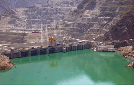


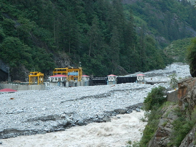
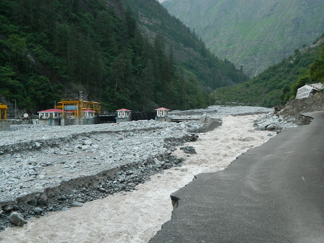


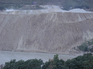
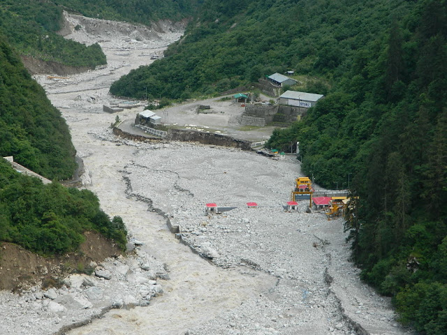


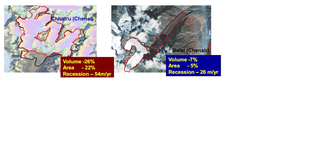


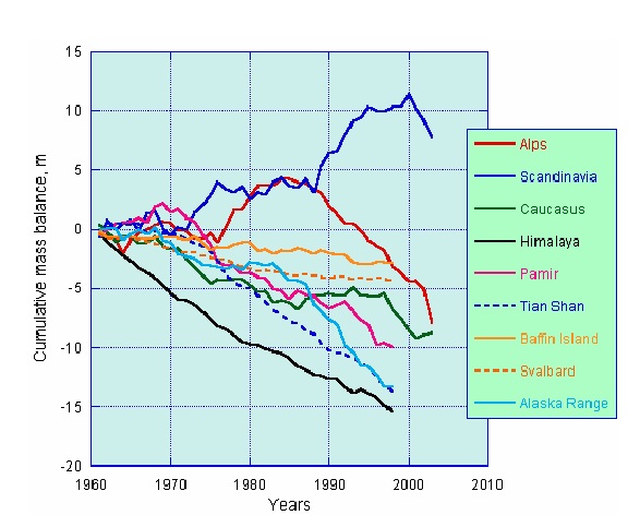
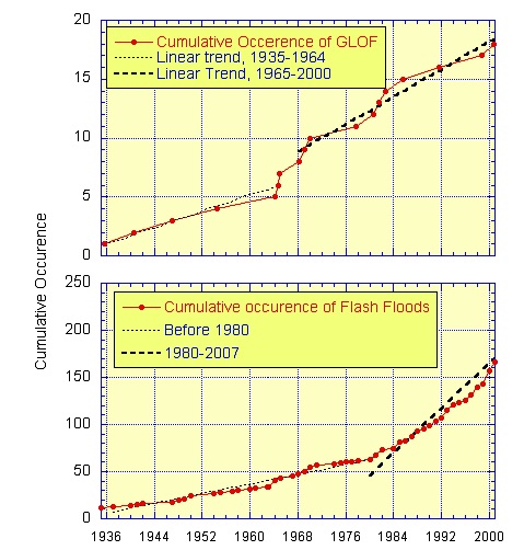


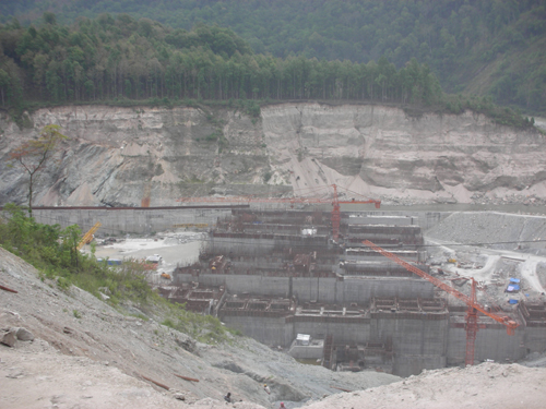


