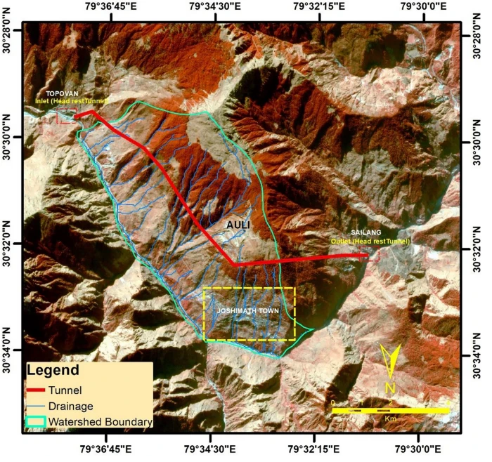
To, July 17, 2025
1 Shri Vinai Kumar Saxena
Honorable LG, Delhi Civil Lines,
New Delhi-110054
Continue reading “Letter: Encroachment of Yamuna floodplain near Wazirabad Barrage”South Asia Network on Dams, Rivers and People
To, July 17, 2025
1 Shri Vinai Kumar Saxena
Honorable LG, Delhi Civil Lines,
New Delhi-110054
Continue reading “Letter: Encroachment of Yamuna floodplain near Wazirabad Barrage”(Feature Image: Copco 2 dam removal on the Klamath River, California. Credit: Swiftwater Films, Source: American Rivers)
China decommissions hundreds of dams along Red river China has claimed to have dismantled 300 dams and decommissioned more than 90 percent of small hydropower stations along the Chishui River, also known as the Red River, a key tributary of the upper Yangtze. The move is seen as one of the largest state-led efforts to restore aquatic biodiversity in Asia’s longest river, reversing decades of hydro-infrastructure development that critically endangered native fish species, including the Yangtze sturgeon, the South China Morning Post reported.
Continue reading “DRP 140725: Dam decommissioning spreads to China”(Feature Image: EOS-RS Flood Proxy Map: New Delhi, Floods, 12 July 2023,v0.4)
July 13 will mark two years since the Yamuna river stretch in national capital witnessed unprecedented flood spell. The river not just submerged every part of existing available floodplain by several feet but also spilled over to reclaim its lost channels. The unusual flood also breached historic 1978 flood level at Delhi railway bridge by a huge margin, setting new benchmark.
Continue reading “Yamuna Manthan July 2025: Is Delhi Ready for July 2023 like Yamuna Floods?”
Guadalupe River Floods: Understanding the tragedy along ‘The Most Dangerous River valley in the USA’
“This is the most dangerous river valley in the United States, we deal with floods on a regular basis.” – Kerr County judge, Rob Kelly about Guadalupe River[i], 5th July 2025
“If you live in the Guadalupe River Basin, you also live in one of the three most dangerous regions in the U.S.A. for flash floods!”[ii] – Opening Statement of “Staying safe: A Guide to Flooding in the Guadalupe River Basin[iii]” published by the Guadalupe River basin Authority
Flash Flood Watch Alert from National Weather Service received 3 hrs 21 minutes ahead of the devastating “30 feet high tsunami ball of water[1]”.
“If you do not want to be flooded, do not build or live in a floodplain”– Guadalupe-Blanco River Authority
And yet, several summer camp buildings built on not only floodplains, but on extremely dangerous floodways[iv]. more than 27 children lost to floods.
Continue reading “Guadalupe River Floods: Understanding the tragedy along ‘The Most Dangerous River valley in the USA’”(Feature Image: Screenshot of inactive hydrograph for Solang station on Beas river in Mandi district. Source: CWC Flood Forecast website)
Despite disastrous flood events causing significant destruction to human lives and infrastructures for past three years, the state of Himachal Pradesh has not seen much required improvements in flood monitoring and forecast servicesby the Central Water Commission’s (CWC) to help minimize the destruction toll.
Continue reading “Himachal Pradesh: Why CWC’s Forecasting is Unavailable Amidst Flood Disaster?”At the village of Jasrath in Lahaul and Spiti, the River Chandrabhaga’s current is swift and strong like a rambunctious toddler. The river is new here, birthed just 16 kms upstream at the confluence of the Rivers Chandra and Bhaga. Chandrabhaga will be named as Chenab only after a journey of about 400 kms downstream. Chenab is one of the largest tributaries of the River Indus whose expansive basin feeds over 250 million people in the heart of Asia.
Lahaul and Spiti district in Himachal Pradesh is a cold desert with very little rain, but the narrow ribbons of land along the Chandrabhaga are emerald with willows, apple orchards and cultivated farms. This is precious land.
Continue reading “A Sinking Village & a Stream that Floods in the Sun: Climate Change, Jahlma Nallah and Lindur in Chenab Basin”In addition to rivers flowing in extreme flood situations at 64 flooding monitoring stations during Southwest Monsoon 2024, we have found that rivers have crossed highest flood level (HFL) at four stations during just concluded Northeast Monsoon season. Of these four stations, three are in Tamil Nadu state and one is in Union Territory of Puducherry.
Continue reading “Rivers Flowing in Extreme Flood Situation during Northeast Monsoon 2024”Guest Article by: Dr. Ruchi Shree
In 2024, Bihar received 19 percent less rainfall than the normal rainfall and one of its districts named Bhagalpur even lesser with 29 percent. From 1 June to October 21, this district of South Bihar situated on the banks of the Ganga received merely 713.8 mm rain while the expectation was 1054.3 mm according to India Meteorological Department figures. It is the third consecutive year when Bihar has received lesser rainfall than expectation[i] and it is likely to worsen the water scenario in the coming years. On the other hand, Bihar faced severe flood this year and Bhagalpur was one of its worst affected districts due to a rise in the level of the Ganga. In a span of around 45 days i.e. from mid-August to end of September, Bhagalpur faced floods four times. This writing is based on my observation of three locations in Nathnagar block of Bhagalpur — two villages named Dildarpur and Biharipur and the Tilka Manjhi Bhagalpur University (TMBU) premise (administrative wing and Lalbagh Professors’ Colony). TMBU is quite close to Dildarpur village (situated on the Diyara land between Champa Nalla/River and river Ganga).
Continue reading “Frequent 2024 Floods in Bhagalpur-Bihar”During southwest monsoon season 2024, SANDRP has tracked at least 64 flood forecast and flood monitoring sites where the respective rivers have crossed the highest flood levels (HFL). Here we present detailed analysis of these sites along with some key observations and other relevant information. SANDRP’s previous reports on the subject can be seen here: HFL breach incidents in 2018, 2019, 2020, May-Sept 2021, Oct.-Nov 2021, May-June 2022, July-October 2022, June-October 2023.
Continue reading “SW Monsoon 2024: Rivers Crossing Highest Flood Levels”(Feature Image: Yamuna rivers in severe flood situation at Pachnada in Etawah, UP on Sept. 14, 2024. Image source Udaybhan)
It is interesting to see that at least 11 rivers at as many flood monitoring sites of Central Water Commission (CWC) located in Bundelkhand region (4 sites) and lower Yamuna basin (7 sites) have crossed old Highest Flood Level (HFL) just in 2 days on September 12-13, 2024. These sites are in 3 different states of Madhya Pradesh (7 sites), Uttar Pradesh (3 sites) and Rajasthan (1 site).
Continue reading “Lower Yamuna Basin: 11 Rivers Crossed old HFLs in just 2 days in Sept 2024”