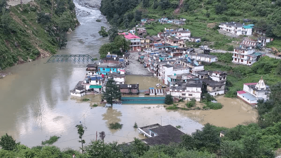
(Feature Image: Buildings submerged in artificial lake following blockage in Yamuna river at Syana Chatti)
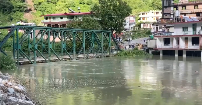
Blockage of Yamuna flows has resulted in formation of an artificial lake in the Yamuna river on August 21, 2025 at Syana Chatti in Uttarkashi district of Uttarakhand. The lake is a result of debris and mud floods in Kupada khad (Garh gaad) after the rains in the morning. The water level in the lake dipped in the afternoon and increased again following fresh debris slide from the stream without any rain activity around 04:30 pm.
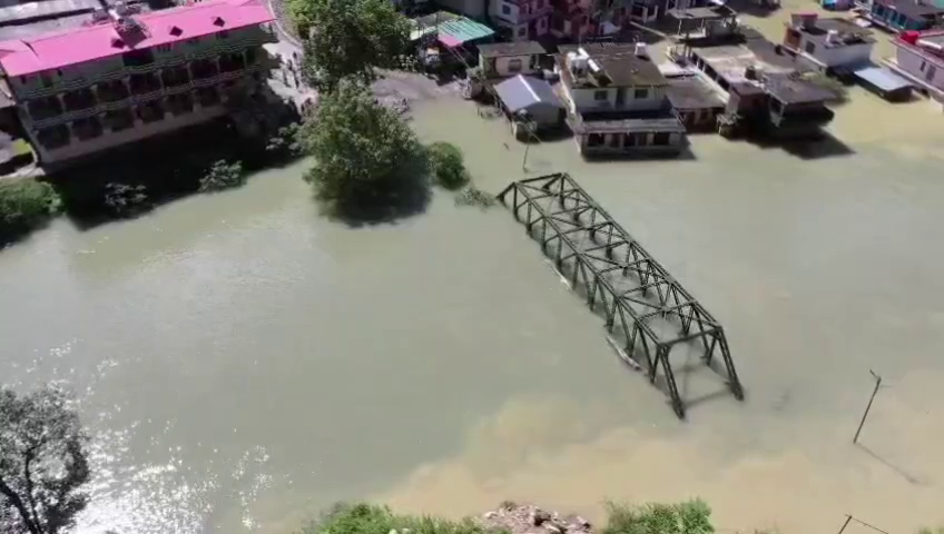
Available information suggests the lake has grown about 150 meter wide and 400 meter long significantly inundating about 30 buildings including a guest house of Garhwal Mandal Vikas Nigam Ltd. (GMVNL), a police chowki, inter college and several hotels along the river in Syana Chhati. A bridge on National Highway (NH) across the river has also been submerged, disconnecting the Syana Chatti and upstream habitats from the district headquarters.
The local police have evacuated about 300 people from the submerged places to safer areas. Alert has been sounded in downstream Ojhari Pujargon, Paligaad, Kuthnor and Kharadi human settlements located along the river. A team of Irrigation, Police and State Disaster Response Force (SDRF) is on stand by mode to deal with any emergency situation. The District Administration is monitoring the situation.
A team of National Disaster Response Force (NDRF) has also reached the site with equipment. As the lone NH bridge on the river has been submerged, the rescue and relief team are unable to reach Syana Chatti.
So far, attempt to breach the lake could not be started due to high flows in the river and reoccurring debris floods from the Kupada gaad. Any sudden breach in the lake has huge flash flood potential, possibly devastating the downstream areas. It might also damage the 8 Mw Gangani hydro power projects in Kharadi.
It is not clear to what extent the course of Yamuna is blocked there. Some reports suggest the flows are blocked completely while this image posted on social media at 05:35 pm on August 21, 2025 by Uttarakhand Police shows considerable discharges form the right side of the river channel. We could not find official information detailing the spread of the lake.
June 2025 Flash Flood: A flash flood in Kupara khad on the intervening night of June 28-29, 2025 had first partially blocked the flows of Yamuna River at the same location. About 9 workers had gone missing due to ‘cloudburst’ induced flash flood on that night at Silai Bend about 5 km downstream of Syana Chatti.
The water level in the artificial lake created then at Syana Chatti had reached close to human habitation. Fearing submergence and flood damages, the residents had raised concerns about the possible threats from the lake. Demanding removal of debris and channelization of river, they had petitioned the Chief Minister and also planned to sit on hunger strike from August 7.
Following this, the Irrigation Department had deployed three poclain machines to open the blockage with some success. But, the quantity of debris and muck this time has undone the past efforts and increased the portion of blockage.
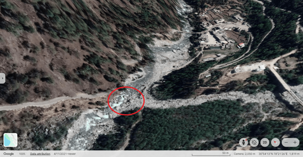
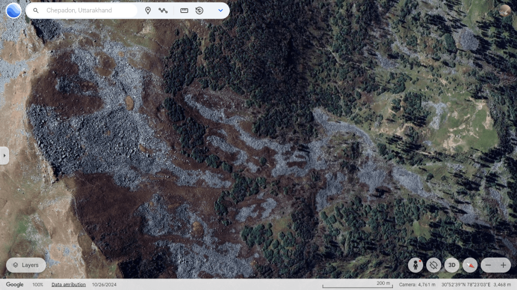
Kupada Gaad: Also called Garh gaad, it joins Yamuna from left bank just 200-meter downstream of Syana Chatti. The stream with about 3 km long steep course is full of rubble and bears severe landslide scars. It originates from a partly snow-covered area uphill.


An Oct 2024 Google Earth image suggests Kupada khad’s catchment upto about 3500 meter uphill is full of moraine debris. Given the narrow valley and quantity of debris in Kupada khad and its catchment, the stream has potential to create such landslide dams and blockage of the Yamuna river course in future too.
Chatti: Chatti meant pilgrim halting point. Syana is second Chatti after Jamuna Chatti enroute Yamunotri shrine about 25 km upstream. The Rana, Hanuman, Narad, Phool, Krishana and Janaki are the other chattis located in sequence enroute the Yamunotri shrine. Some details about these halting points can be seen here.
SANDRP
Note: This is a developing situation and we will update this report with further information that becomes available.
Postscript: (10:00 pm, Aug. 22) This report quotes Disaster Management and Rehabilitation Secretary Vinod Kumar Suman stating that at present, water is being drained out from one side of the river. However, due to marshy ground, channelisation has not yet been possible. Relief and rescue teams are considering alternative options as well. As per the report, a team from the Central Water Commission (CWC) is at Syana Chatti and is also monitoring the Yamuna water level. According to the Executive Engineer, Irrigation Division, Purola, the Yamuna river water is flowing along the edge of the blockage, and the water level has reduced.
During the day (Aug 22) the administration carried out a drone survey of the lake and planned to try controlled blasting to increase the discharges from it. Meanwhile, the locals staged a protest entering the lake waters around the submerged bridge blaming the administration’s negligence in past two months resulting in the present-day crisis.
This video post suggests there is some increase in discharge from the lake after the use of controlled blasting during the day.
10:30 pm, Aug. 22: This video by Ramesh Rana shows the blockage situation better there. It seems a huge chunck of land mass adjoining Kupada khad slipped into the stream from left side after rainfall in the area yesterday thus blocking a large part of Yamuna riverbed at the confluence.
02:00 pm, Aug. 23: The hydrograph of CWC’s Kuthnaur site which is located about 10 km downstream Syanachatti shows Yamuna water level increased by 2 meters in 02:00 hour from 1427.1 meter at 01:00 hour to 1429.1 meter at 03:00 hour on 23.08.2025 before falling down. Clearly this is after the breach in the artificial lake at Syanachatti. The rise is just 0.2 meter lower than 1429.3 meter HFL attained at the site on 03.07.2025.

Notably, earlier the HFL for the site was 1428.9 meter dated 29.06.2025. This HFL was attained after a ‘cloudburst’ induced flash flood around Silai Bend area upstream Kuthnaur in the intervening night of June 28-29, 2025. Interestingly, earlier CWC maintained 1441.35 meter HFL dated 18.08.2019 for the site which is higher than the HFLs attained in June and July 2025.
As per this report the lake was about 350 meter long, 36 meter wide and 20 feet deep. This post by District Magistrate in the morning shows pictures of water level in the lake receding down by two feet from the submerged bridge and buildings areas. Another post by the DM around 10:00 am shares that the lake has been drained and debris, sludge are being removed from the bridge and road.
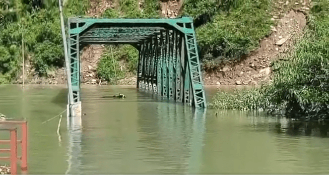

Status of submerged bridge on Aug. 21, 22 and 23.

04:00 pm, Aug 23: Presently, it seems the lake has been drained to great extent and there is no immediate submergence and flood threats. However, the debris around the blockage point needs further removal. As already mentioned, the Kupada khad course and catchment is full of such debris and loose materials, continuous monitoring and removal of these materials are required to avoid formation of artificial lake there in future. The landslide near the stream and slope failure along its course has potential to aggravate the flash flood situation.


The perennial Dabarkot-Ojhari landslide zone about 700 meters downstream the blockage point also has similar disaster threats. The NIDM Aug. 2012 report also mentions that a landslide event in Khanera village about 12 km downstream Syana Chatti had created a 300 meter long, 30-40 meter wide and 5-6 meter deep artificial lake on Yamuna river in August 2001. The report also documents landslide risks at Pujargaon and Pali gaad in the upper Yamuna river valley.

Another cloud burst has been reported from Chamoli district’s Tharali on 22nd night causing large scale damage.
Meanwhile, artificial lake on Bhagirathi continues to submerge Gangotri highway blocking traffic and supplies to the holy place which is a much congested town by now.
People of Uttarakhand always defender their migration due to lack of amenities when political parties used it as an alibi to impose large scale of unscientific slope cutting and tunneling around Himalayas like in plains. Due to large scale deforestation, Uttarakhand hills are naked, their streams are drying up and continuous spell of monsoon rains are rampaging their normal life and causing losses. Is it what the people really wanted?
LikeLike