(Pre and post flood images of Tibet’s Pyurepu Glacier region. Source)
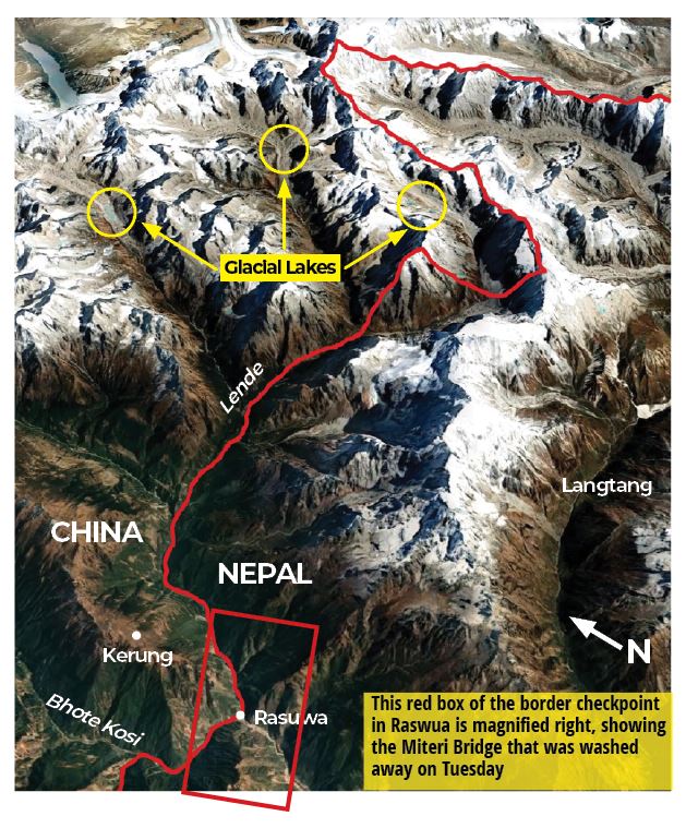
A Glacial Lake Outburst Flood (GLOF) disaster in Lehende Khola river impacted several hydro-electric power (HEP) projects in Nepal on July 8, 2025. The deadly flood occurred around 3 am in Rasuwa and Nuwakot districts of Nepal bordering Tibet region under China control. As a result, the water level in Lehende river rose by 3.5 meters in Timure, Rasuwa. The merging of Kerung and Lehende rivers in Tibet forms the Bhotekoshi river in Nepal and it is part of Trishuli sub-basin under Narayani river system.
The figure of number of hydro projects damaged varies from 4, 5, 8 to 11 HEP projects. One report claimed that more than 10 HEPs were damaged in the Bhotekoshi flood disaster. The damaged HEPs included both operational and under-construction projects.
One report mentioned damage to the 8 HEPs including 5 were operational and 3 under construction. The operational HEPs included 111 Mw Rasuwagadhi, 22 Mw Chilime, 60 Mw Trishuli 3A, 25.25 Mw Trishuli and 14 Mw Devighat HEPs facing damage to varying extent. The impacted under construction HEPs included 37 Mw Upper Trishuli 3B, 216 Mw Upper Trishuli 1 and 100 Mw Super Trishuli.
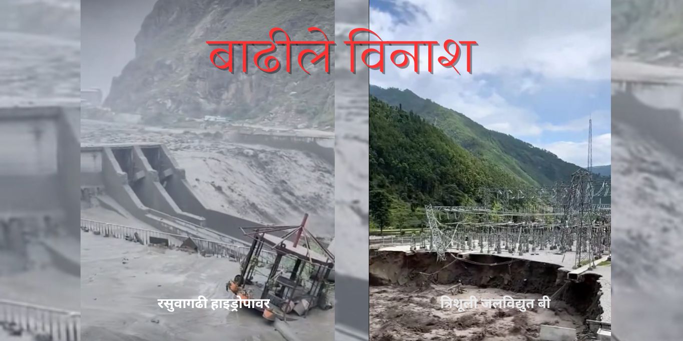
The 111 Mw Rasuwagadhi HEP was among the most affected HEPs. It is located just 200 meters from the Tibet border. The sudden flood washed away its head works, dam, gate structures, access roads, temporary cofferdam, campsite, 9 vehicles and left two bridges vulnerable. The floodwater also entered the tunnel and submerged part of project infrastructure under two to three stories of debris stated project chief Satyaram Jyakhwa.
The 60 MW Trishuli 3A HEPs was also hit hard by the disaster. The flood swept away its gate and destroyed the headworks, forcing the plant to shut down completely. Hitendra Dev Shakya, Managing Director (MD), Nepal Electricity Authority (NEA) stating that the Trishuli 3A’s dam lost one of its gates. Other report mentioned that the dam of the Upper Trishuli-3 ‘A’ was buried halting the power production and two gates of the dam were damaged.

As per MD, NEA, the under construction Trishuli 3B HEP which was 50 per cent complete, faced critical problem as a temporary tower installed at the project site was washed away after the river eroded its foundation. Due to the scale of damage, especially at Rasuwagadhi and Trishuli 3A, resuming operations in the near term was not feasible stated Baburaja Maharjan, CEO of Chilime HEP.
Power generation was stopped at Chilime HEP due to damage to project’s drainage system and headworks. Flood also entered the tailrace of the HEP.
As per the NEA the flood changed the course of Trishuli river and entered the Trishuli-3 ‘B’ hub substation and damaged the structure. A landslide damaged the power plant of Jhankre Khola HEP at Baseri of Jiri Municipality-9. The 635 kW HEP collapsed and the power generation unit was shut down.
The 25 Mw Trishuli and 14 Mw Devighat HEP power stations on the lower banks were shut down due to the floods. Initial estimate suggested financial losses more than Rs 5 billion due to the damage caused to the HEP projects.
The flood brought debris and sediment in huge amount and resulted in shutting down of about 250 Mw capacity generation from 7 HEPs and halted the construction of other HEP projects with a combined capacity of 350 Mw in the Rasuwa stated Rajan Dhakal, spokesperson NEA said.
Power generation was halted also at the 14 Mw Upper Mailung Tadi HEP and 5 Mw Mailung Khola HEP due to damage at the Trishuli–3B hub substation, which channels electricity from these projects. All these HEPs were located in the Trishuli corridor.
All the affected projects -except for Devighat, Trishuli, and Trishuli–3A -had private sector involvement.
In his landslide blog, Dave Petley quotes Kirsten Cook of the Université Grenoble Alpes who posted to Bluesky some seismic data from a station near to Kathmandu (a long distance downstream of Rasuwagadhi), which shows recording of the flood in seismic signals an hour before it arrived at the border.
In a separate flash flood disaster on July 9 morning the Kalung Khola HEP was also completely damaged in Baglung district of Nepal. The deluge washed away the project dam along with the powerhouse besides sweeping away a Steel Bridge constructed last year at the cost of Rs 3.5 million. The disaster also damaged a transformer disrupting power supply to a total of 130 households in Paiyuthanthap.
Reason: Soon after the disaster, the Flood Forecasting Division under the Department of Hydrology and Meteorology, Nepal began investigating the cause of the flood. Initially heavy rains, permafrost collapse, breach in landslide lake were suspected a reason behind the disaster. However, experts including scientists at the International Centre for Integrated Mountain Development (ICIMOD), ruled out these factors.
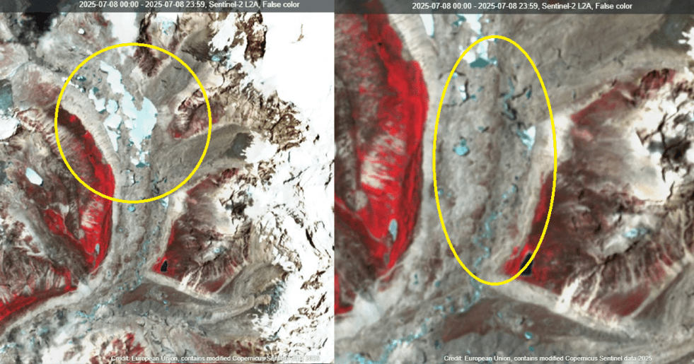
Later, in a press brief on July 9, the National Disaster Risk Reduction and Management Authority (NDRRMA) tentatively concluded that the rupture of a Tibetan glacier lake resulted in the massive cross-border flood. The analysis of the available satellite imageries also revealed that water flowing from the Puripu Glacier caused the flood in Bhotekoshi.
Further, this detailed informative report revealed that, “A rapid hazard assessment published by the Institute of Mountain Hazards and Environment (IMHE), the University of Alaska Fairbanks, and Highrisk.org confirmed that the lake atop the Pyurepu Glacier drained within a single day. The joint report stated that the lake had gradually formed from March 2025, increasing in size until it reached a maximum of 638,000 square meters on July 7. By July 8, following the rupture, the lake had shrunk to 435,000 square meters.”
In a statement the ICIMOD also stated that the China-Nepal flood was caused by draining of ‘supraglacial’ lake that started forming as a small pond at the end of Dec 2024 and grew significantly in June 2025. The supraglacial lake was formed in the middle of a glacier and was located about 35 kms above Rasuwa in Tibet. After a large lake had formed due to melting snow, the glacier released the water as a flood, according to officials of the NDRRMA.
Questions over Data Sharing, Forecast, Disaster Preparedness: Officials in Nepal were unaware of the flood until the waters reached Betrawati, the border point between Rasuwa and Nuwakot districts, due to the lack of a real-time data-sharing mechanism with China. This is despite experts in the past stressing on the urgent need for improved early warning systems (EWS) and cross-border cooperation highlighting Nepal’s vulnerability to climate change and extreme weather events.
Officials said that a few weeks ago, China had issued a notice to exercise caution along the banks of rivers originating in Tibet. But since there was no forecast for rain, the occurrence of floods raised suspicions of some unusual incident.
As per Nepal’s Department of Hydrology and Meteorology there was no established mechanism for information sharing on floods and rains from the northern side. Experts blamed the authorities for their failure to recognize extreme weather events and work on preparedness measures. After the disaster, they have again urged the government to establish an information-sharing mechanism and diplomatic collaboration with China to mitigate the risks of loss of lives and damage to property in the future.
Highlighting impact of similar GLOFs in recent past, this report mentioned that the Rasuwa disaster has once again spotlighted the threat that Nepal is susceptible to due to its exposure to climate disasters. Ngamindra Dahal, a water and climate analyst, said Nepal needs to adopt a multi-scale approach to mitigate the disasters in the northern region. As per him, haphazard construction, including that of hydropower projects, can have cascading effects, resulting in floods.
Raising these important points, another detailed report stated that the damage caused by this flood is yet another reminder of the chronic vulnerability of hydropower projects and other in-stream infrastructure to extreme events, across the Himalayan region. Because Rasuwa’s Bhotekoshi/Trishuli watershed is one of the most intensively developed rivers in Nepal, this event also demonstrated how a cascading series of hydropower projects can be affected by a single extreme flow event.
Other Damages: At least 9 human beings were killed in the disaster and 18 individuals including 12 Nepali and 6 Chinese nationals went missing. Of 12 missing from Nepal included 3 police officials and 9 public.
In total the deluge swept away about 65 vehicles including 24 containers, 35 vehicles and 6 trucks stationed at the dry port in Timure, near the Nepal–China border. The under-construction dry port was completely damaged. The flood washed away the Miteri Bridge on the border, cutting off direct road connectivity between the two countries. Preliminary estimates suggested damage worth hundreds of millions of rupees, including losses to mobile phones, electronics, clothing, and fruits.
The flood has also swept out sections of the Pasang Lhamu Highway, cutting off vehicular access to Rasuwagadhi and severely disrupting connectivity in Rasuwa district. Several other vehicles and bridges were damaged. The flood blocked the Syafrubesi-Rasuwagadhi section of the highway under Gosainkunda Rural Municipality-2, triggering landslides and severe road erosion. On Tibetan side, 11 people including 9 construction workers and 2 road maintenance workers went missing and 350 were displaced by the disaster.
SANDRP
