
About Himachal Pradesh
5 river basins; Total Area: 55,000 square kms.; Total Population: 68.65 lakhs; Total Catchment Area of 5 rivers; Total Catchment Area: 53311 sq.kms
Himachal is a relatively small state and in 2011 its population stood at 68.65 lakhs. It is only 9% urbanised and most of Himachal lives in its villages. Of the total land geographical area only 10% is under agriculture while close to 70% in under the category of ‘Forest land’. And yet agriculture is the main source of livelihood in Himachal with over 93% of the population dependent on it. As in most mountain areas agriculture and forest dependence is interwoven.
Agriculture is made possible due to the irrigation from river channels or natural springs. The health of the forests directly determines the health of the surface and ground water systems which in turn determines the viability of agriculture and horticulture. Horticulture and cash based agriculture was pushed by the government in the late 70s and 80s. Today the state has massive apple cultivation, apart from commercial vegetable cultivation, which is an important source of income for the farmers.
Post the 90s, while Himachal has witnessed changes that the rest of the country was going through as a result of the economic reforms and push to the neoliberal agenda, this process has been slower here. Despite this over the last two decades commercial tourism has seen a massive rise, with the number of tourists visiting the state having doubled in the last decade. The other major driver of economic growth in the state has been the Hydropower sector. Himachal has the largest hydropower installed capacity in the country – more than 10000 MW, out of a total potential of more than 27000 MW (Govt. of HP, 2015-16). In such a scenario the nature of development is bound to impact the state of the rivers.
A brief profile of the state and its major river basins

Himachal Pradesh a mountain state in Indian Himalaya, covering an area of over fifty five thousand square kilometres, has 5 major river basins Satluj, Ravi, Beas, Chenab and Yamuna. Yamuna crosses only the south-eastern border of the state, and but its tributaries originating in Himachal include Giri and Tons which form a part of the Ganga river basin flowing westward. The other four rivers are major tributaries of the eastward flowing Indus River, the longest in the world (2000 miles or 3200 kilometres) with a flow twice the size of the Nile. The Indus becomes a much larger river once it is joined by what are known as the ‘Punjab’ (literally meaning 5 rivers – Satluj, Ravi, Beas, Chenab and Jhelum).
Of the four Himachal Rivers, except Satluj which has its source in Tibet, the rest originate within the boundaries of the State of Himachal Pradesh. While the Satluj meets Beas meet within India, it joins the Chenab in Pakistan. Ravi too joins the Chenab in Pakistan. Chenab then goes on to meet the Jhelum and then the merged rivers meet the Indus at Mithankot in Pakistan followed by its confluence with the Arabian Sea. Himachal’s unique geography and variation in altitude produces a wide spectrum of climates from hot and sub-humid tropical in the southern tracts to cold, alpine and glacial in the northern and eastern mountain ranges. There is a vast diversity of communities that reside in this landscape.
While the large rivers are referred to by them locally as dariya, their tributaries (glacial and snow fed) are smaller rivers are called khad, and smaller streams are known as nallahs. The, khads and nallahs, are critical components of the riverine ecosystem, even from the point of view of the local communities, who have a direct relationship with these for their day to day use – drinking water, irrigation, running watermills and fishing. It is rare to find communities residing very close to the larger rivers or dariyas, except in some parts of Lahaul-Spiti or then lower down in the valleys.
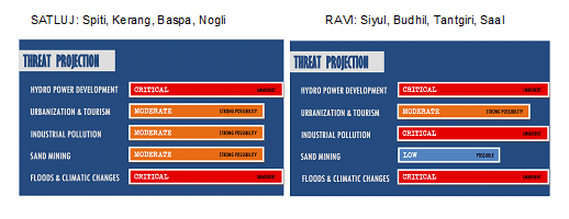
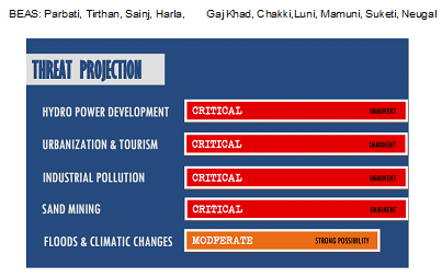
Images showing major threats on the major rivers of the State

A report by Dr. Manshi Asher (manshi.asher@gmail.com)
Notes:-
- This report was commissioned for India Rivers Week 2016.
- The Himachal Pradesh Drainage map has been put together by a WWF Team led by G Areendran, the names of the rivers have been provided by an INTACH Team led by Dr. Manu Bhatnagar.
- The names in bracket represent the Key tributaries; RED color is for (Critical) status; BLUE is for (Safe) status and rest are ORANGE (instead of PINK in this report) (Threatened) status.
- Its a short description, for detail report kindly explore the link Himachal Rivers Profile
- You may also like to see rivers profiles for Rajasthan, West Bengal, North-East India, Maharashtra , Haryana, Uttarakhand States
- The same report can also be seen on India Rivers Week Blog

I see the Zangskar tiver is named as Zaskar river on this map as per early 20th century maps. What actually is the correct spelling?
LikeLike