Union Environment Minister Anil Madhav Dave on January 5, 2017 reportedly told a meeting called by his ministry of non-official members of statutory bodies like expert appraisal committees and forest advisory committee, “How can we hold up development and not fulfill the needs of the poor for the sake of birds and animals?” This is of course a shocking statement to come from a minister whose mandate is to protect environment!
No less disturbingly, even as an environment minister, he has several times advocated pushing the Ken Betwa River Link Project (KBLRP) as a pilot scheme, when the project does not have any of the final clearances from his own Ministry!
Intriguingly, over six years earlier, on Aug 12, 2010, while participating in a debate in Rajya Sabha, the same Mr Dave had taken a diametrically opposite view on mega dams. He said[i]: “The water available for dams in the upstream is decreasing, the dams are unable to generate claimed power, in the downstream the rivers are dying, these are huge changes. If there is an honest assessment of this, truth will come out… but for God’s sake do not get such assessments done by bureaucrats.”

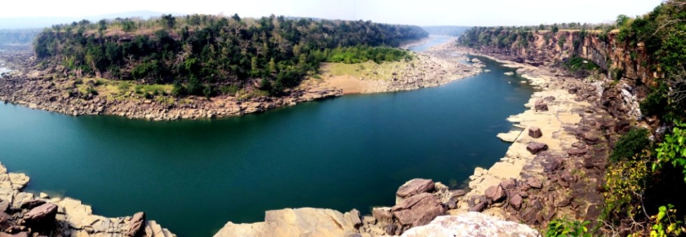
Funnily, for all the hyperbole about the KBRLP, the most essential information, that is how much water is there in Ken or Betwa rivers remains a state secret! It is not in public domain! I as a member of the erstwhile committee on Inter Linking of Rivers set up by Ministry of Water Resources, had asked this information to know if indeed Ken is surplus and Betwa is deficit in water, but I was told that information cannot be divulged even to the official expert committee, since Ken-Betwa are part of the Ganga basin which is an international basin! So there is no way to confirm the government claim that Ken has surplus and Betwa is deficit in water availability. No independent review of this claim has been done ever. However, available information shows that the whole exercise of proving that Ken has surplus and Betwa is deficit is an exercise in manipulation to achieve the pre-decided objective. More importantly, while groundwater remains India’s water lifeline, NWDA’s Hydrological assessments do not take into account the groundwater-surface flow dynamics at all!
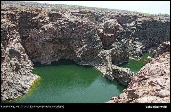
And the Environment Minister should know that Forests are not only for “bird and animals” they are the nurtures of a river. If 10500 ha of Panna Tiger Reserve in Ken river catchment is destroyed by the project as mentioned by the minutes of the National Board of Wildlife meeting in Aug 2016, it will have a huge impact on the hydrology of the river. But sadly, the most shoddily done Environment Impact Assessment of Ken-Betwa project done by the Agriculture Finance Commission Ltd does not even mention this.
But let us look at the issue a bit more methodically. There is a widely prevalent notion that KBRLP is for the benefit of Bundelkhand area.
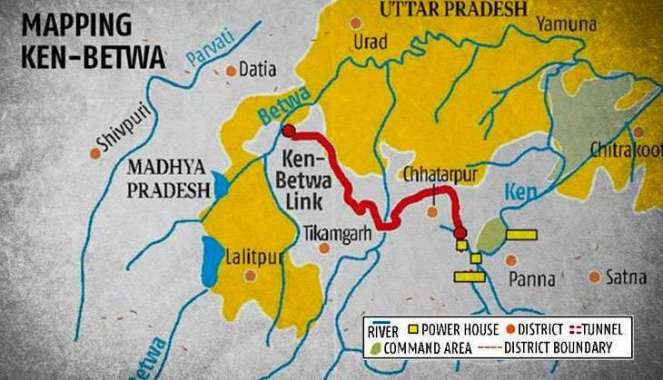
Let us get this misconception cleared right in the beginning. The official executive summary of the Detailed Project Report of KBLRP on NWDA website says: “The main objective of the Ken-Betwa link project is to make available water to water deficit areas of upper Betwa basin through substitution from the surplus waters of Ken basin.” Upper Betwa basin (Raisen and Vidisha districts of MP) is not in Bundelkhand[ii]. So KBLRP is essentially facilitating export of water from drought prone Bundelkhand to area outside Bundelkhand, which, in fact is well endowed with over 900 mm of average annual rainfall.
The DPR further says, a third o the surplus water will be utilized for “enroute irrigation of 0.60 lakh ha. in the districts of Tikamgarh and Chhatarpur of MP and Mahoba & Jhansi of U.P.” The claim in the minutes of Expert Appraisal Committee meeting of Dec 30, 2016 that “It is proposed to provide irrigation facility in 6,35,661 ha of area in Panna, Chhatarpur, Tikamgarh Districts of Madhya Pradesh and Banda, Mahoba and Jhansi Districts in Uttar Pradesh” needs to be put in context here. Firstly, this claim is far in excess of what the presumed surplus water can irrigate.
Moreover, a total of 5.15 lakh ha of cultivable lands in these six districts is projected to benefit, which constitutes about 12.5% of total cultivable land of Bundelkhand. So at least 87.5% of cultivable land of Bundelkhand is not even planned to get any water from the KBLRP. A significant part of the projected benefit area (e.g. Banda as also in other districts) is already irrigated. So less than 10% of cultivable land of Bundelkhand is to get benefit from the project and even for this, there are much better options available as exemplified by the Planning Commission and a number of civil society initiatives.
The whole ongoing exercise of securing statutory environment, forest and wildlife clearances for this project is seriously compromised at each step of the way from impact assessment, public consultations appraisal and governance. So much so that Union Water Resources Minister Uma Bharati publicly threatened the regulators that if they do not clear the project, she will go on fast! When the Expert Appraisal Committee, in its meeting on Dec 30, 2016 decided to recommend environment clearance to the project, it did so against evidence of shoddy EIA, public consultation process that involved violations, went against the NBWL condition that non essential power component needs to be shifted out of the protected area and went against the decisions of earlier five EAC meetings. It also ignored the legal requirement that projects on Ganga river or any of its tributaries should be cleared by the District, State and National Level Ganga River Conservation Authorities as per the Government of India Ganga notification of Oct 7, 2016. Interestingly, the same MoWR Minister called KBRLP as “model link project”! The completely compromised clearance process makes the progress legally untenable.
Why then is the project being pushed? As a top official in Ministry of Water Resources told us last month, it is going to be about Rs 30 000 crores project, if not more. There is a strong contractor-politician-bureaucrat-engineer-consultant nexus that sees huge opportunities in a project which involves so much money, he told us. We hope the legal institutions see through all this and would stop this madness.
Himanshu Thakkar (ht.sandrp@gmail.com, https://sandrp.wordpress.com/)
[And edited version of this was published in DNA on January 21, 2017, see: http://www.dnaindia.com/analysis/column-much-to-lose-for-bundelkhand-when-ken-meets-betwa-2294515]
END NOTES:
[i] http://rsdebate.nic.in/bitstream/123456789/402997/2/PD_220_12082010_p311_p336_15.pdf and https://www.youtube.com/watch?v=W3GbuPjRj6A
[ii] According to erstwhile Planning Commission, “Bundelkhand region is located between 23020’ and 26020’ N latitude and 78020’ and 81040’E longitude. Administratively the region comprises of thirteen districts – seven districts of Uttar Pradesh viz., Jhansi, Jalaun, Lalitpur, Hamirpur, Mahoba, Banda and Chitrakut and six districts of Madhya Pradesh viz., Datia, Tikamgarh, Chattarpur, Damoh, Sagar and Panna.” See: http://nraa.gov.in/pdf/drought%20mitigation%20strategy%20for%20bundelkhand.pdf, http://dolr.nic.in/dolr/downloads/spsp/SPSP_Uttar%20Pradesh.pdf, http://www.mpkrishi.org/EngDocs/Agritop/Compendium/chapter1.aspx
