Cumulative Impact Assessment · Ministry of Environment and Forests

Uttarakhand Deluge: How human actions and neglect converted a natural phenomenon into a massive disaster

Analysing a natural disaster is a complex task. Many a times, a natural disaster and its human impacts are a result of multiple things occurring together. At the same time, disasters like the one being faced by Uttarakhand currently highlight the stark anthropogenic reasons which contribute towards causing the disaster as well as increasing its impacts manyfold.

SANDRP has been trying to analyse the situation, and looking at number of causes which precipitated in the current tragedy. These include the absence of early warning system, absence of responsible and active disaster management of monitoring system. While the calamity is natural in the sense that the region did receive extreme heavy rainfall and cloud burst, the root causes which increased the human tragedy include unchecked and unplanned infrastructure development along the rivers and development of  hundreds of hydel projects in the fragile zone without proper checks and balances, transparent studies and decision-making processes.

A brief update on SANDRPs work on this issue as well a compilation of the numerous ways in which hydel projects in Uttarakhand are flouting norms of sustainability, transparency, participation or safety and what has been the response to this from the highest quarters: Prime Minister, Minster and Ministry of Environment and Forests as well as the state administration.

The first thing that strikes you when you analyse this disaster is that there was no specific and timely warning of impending disaster from the IMD or any other body (their claim to the contrary not withstanding). In fact we do not have a system in place to forecast cloud burst events, when technology is available to achieve that at approximate cost of Rs 15 crores, as informed to me by formed Director General of IMD, Dr S K Srivastava.

Secondly, even after the event of rainfall started and occurred, till date, six days after the event started on 15th, there is no account of how much rainfall occurred at what specific locations, and what was done to alert the populations that were at risk. This is again a failure of IMD and local administration. In fact it transpired that Kedarnath, one of the most affected area, has no raingauge, says Indian Express.

This shows how agencies like IMD, CWC, NDMA and SDMA have failed to put in place basic systems of warning, forecasting, monitoring and information dissemination that can greatly reduce disaster potential of any area.

In April 2013, a CAG report said that Uttarakhand state disaster management authority, which was formed in Oct 2007, has never met till date. Nor has it mandatory “rules, regulations, polices or guidelines”, first step for the authority to have functional existence. (for elaborate excellent information on this CAG report, see: http://www.indiatogether.org/2013/jun/gov-disaster.htm, for CAG report, see: http://saiindia.gov.in/english/home/Our_Products/Audit_Report/Government_Wise/union_audit/recent_reports/union_performance/2013/Civil/Report_5/Report_5.html)

See: http://timesofindia.indiatimes.com/india/Uttarakhand-disaster-plan-doesnt-exist-CAG-warned-in-April/articleshow/20690268.cms

RAINFALL EVENTS OF JUNE 15-18 IN UTTARAKHAND

From all accounts it is clear that areas around all four Pilgrimage centres (Gangotri, Yamunotri, Kedarnath and Badrinath) and the fifth one of Hemkunt Sahib have faced some serious floods this season. In addition, areas of Pithoragarh (Goriganga basin) and Himachal Pradesh (Kinnaur district, mainly Kashang area, a tributary of Sutlej) basin also faced floods during the same period. The rainfall event that lead to these floods started on June 15 and went on till June 16-17.  It seems strange to see such vast area facing simultaneous high intensity rainfall. IMD officials tried to explain this (http://www.hindustantimes.com/India-news/NewDelhi/Westerlies-collided-with-monsoon-to-rain-death/Article1-1081810.aspx) as collision of western disturbance with the upcoming monsoon clouds. It is also true, as Anupam Mishra ji explained to me that the catchments of all these basins in their uppermost ranges are not too far from each other. Incidentally, Tibetan area is also not very far from these region, it would be interesting to know if that area also faced cloud burst events in this period.

In an interview with Rediff Editor Sheela Bhatt, NDMA Vice Chair M Shashidhar Reddy accepted that there are no rain-gauges at Kedarnath and Badri nath and hence we may never know how much rainfall feel at those sites and we will never have full scientific explanation of what happened on June 16-17.

The best we have is weekly district wise rainfall in Uttarakhand districts for the week June 13-19, from India Meteorological Department:

DISTRICTWISE RAINFALL DISTRIBUTION

13.06.2013 TO 19.06.2013

DISTRICT (NAME) 

ACTUAL (mm)

NORMAL (mm)

    % DEP

CAT.

ALMORA

208.7

26.3

694%

E

BAGESHWAR

391.2

26.3

1387%

E

CHAMOLI

316.9

22.6

1302%

E

CHAMPAWAT

351.0

33.5

948%

E

DEHRADUN

565.4

36.8

1436%

E

GARHWAL PAURI

149.7

15.8

847%

E

GARHWAL TEHRI

327.7

22.0

1390%

E

HARDWAR

298.8

21.6

1283%

E

NAINITAL

506.5

38.8

1205%

E

PITHORAGARH

246.9

73.0

238%

E

RUDRAPRAYAG

366.3

53.9

580%

E

UDHAM SINGH NAGAR

157.7

40.2

292%

E

UTTARKASHI

375.6

25.8

1356%

E

Events of June 16-17 at Kedar Nath Based on Media information, it seems Kedarnath shrine saw two massive flood events, one starting around 8.15 pm on June 16 and second at 6.55 am on June 17. The flood witnessed at the shrine (located at 3584 m above msl) originated from catchment that includes two mountain peaks: Kedarnath and Kedarnath Dome (6831 m elevation). Following torrential rains possibly triggered by cloude burst, huge boulders broke away from Kedar Dome and ruptured the downstream charbari lake reservoir, about 6 km upstream from the temple along the Mandakini river. This description seems to suggest that this was also an event of GLOF (Glacial Lake Outburst Flood), though no one seems to have used that term so far.

Another instance of GLOF in this Uttarakhand flood disaster could have happened at Hemkunt Sahib pilgrim centre (elevation 4632 m), where report suggest, the level of water in the lake surrounding the shrine suddenly “increased as glacier from the uphill came down.” http://www.business-standard.com/article/current-affairs/no-damage-to-hemkunt-sahib-gurdwara-trust-113062200532_1.html

However, from all accounts, the massive rainfall and cloud burst events were happening at multiple places, including in Bhagirathi basin, Assiganga basin, Mandakini Basin, Badrinath region, other places in Alaknanda region, among others. The high rainfall started sometime on June 15 and went on till at least June 18. When I talked with Prof Bharat Jhunjhunwala staying at Devprayag along the confluence of Bhagirathi and Alaknanda, he said that the peak of the floods happened on the morning of June 17 (The Hindu reported this happened at 3 am on 17th), though massive flood event there in Alaknanda started the previous evening. He also mentioned that the massive amount of muck deposited on the Alaknanda riverbed by the under construction 330 MW GVK Srinagar Alaknanda Hydropower Prooject (the project has had no credible environmental impact assessment) accentuated the flood disaster in the downstream area. The Hindu reported (http://www.thehindu.com/todays-paper/tp-national/no-warning-of-dam-water-release/article4844604.ece) that sudden release of water from the dam along with the illegally dumped muck in the river bed lead to disaster in downstream Srinagar town.

A Sphere India report said that in Rudraprayag (this is likely to be one of the Mandakini hydropower projects, either Phata Byuang or Singoli Bhatwari), “The local are saying the muck of the dam was deposited along the river which has diverted the course of water.” (http://www.sphereindia.org.in/Download/Sitrep-3%20Flood%20Incident%20in%20Uttarakhand.pdf)

It is interesting to note that if these accounts are correct, the peak of flood event at Devprayag and Kedarnath (separated by about 150 km) happened on the morning of June 17, which possibly indicates that there were multiple could burst or very high intensity rainfall events in Alaknanda valley alone.

However, I had already received a detailed report from Uttarkashi Apda Prabanthan Jan Manch with photos of unfolding disaster on the evening of June 16, 2013, so the high rainfall event and beginning of flood  disaster at Uttarkashi began much earlier. The news channels were already showing live footage of the event unfolding in downstream Rishikesh and Haridwar on June 17, again indicating that the flood event in the upstream mountains must have started at least two days earlier.

Unfortunately we still do not have an accurate account of this whole episode from any of the official agency. When Vice Chairman of National Disaster Management Authority M Shashidhar Reddy was asked about this by me on NDTV INDIA badi khabar programme on June 21 evening (see: http://khabar.ndtv.com/video/show/badi-khabar/280131), he accepted we still do not have that account six days after the event. This shows the poor monitoring situation from all concerned.

UTTARAKHAND AND GLOFS The mention of GLOFs in the context of current Uttarakhand floods above should trigger other thoughts. In fact not many observers are mentioning GLOFs in current context. However, Climate scientists including ICIMOD has been mentioning increasing risks of GLOFs all across Himalayas.

This blog (http://blogs.agu.org/landslideblog/2013/06/27/new-high-resolution-images-of-kedarnath-the-cause-of-the-debris-flow-disaster-is-now-clear/) provides satellite images from Indian Space Research Organisation to explain the occurrence of GLOF in the current disaster at disaster and its consequences in the downstream Rambara area. Its Author Dave Petley, dean of research and global engagement, Wilson Professor of Hazard and Risk at DurhamUniversity in the United Kingdom, tries to explain the events around Kedarnath in an interview to Rediff editor Sheela Bhatt: http://www.rediff.com/news/interview/india-should-prepare-for-a-large-earthquake-in-uttarakhand/20130702.htm?sc_cid=emailshare&invitekey=ae3f4cec4fbfe5ba6bb3ee0fa5698550&err_accptd=1

Similar images are also available on Down to Earth article (http://www.downtoearth.org.in/content/floods-uttarakhand-explained) and NRSC website (http://www.nrsc.gov.in/).

Anupam Mishra ji in fact mentioned in NDTV INDIA discussion (http://khabar.ndtv.com/video/show/hum-log/280415) mentioned is 1977 article (see in Hindi: http://mansampark.in/2013/06/22/uk/) where he describes the 1970 floods and also the 1893 glacial dam burst, flood due to bursting of which was monitored and local people alerted by the then British government in collaboration with local people.

Chorbari Glacier The Chorabari glacier that played a role in current floods in Kedarnath lies between latitudes 30°44′50″N and 30°45′30″N, and longitudes 79°1′16″E and 79°5′20″E, from an altitude of approximately 6,000 m (20,000 ft) at the slopes of Kedarnath peak, to 3,800 m (12,500 ft). The glacier is around 7 km in length, while the basin area of the glacier is approximately 38 sq km and the glacier ice cover is 5.9 sq km. The glacier slope is around 11 degrees and faces south. The glacier has two snouts. It is hypothesized by R. K. Chaujar that an original single glacier covered the area, which while receding, split into two snouts. One of the snouts is the source of the Mandakini River at 3,865 m (12,680 ft). The other snout, at 3,835 m (12,582 ft), drains into the Chorabari Tal. (http://chimalaya.org/2013/06/19/disaster-in-uttarakhand-india-huge-death-toll/)

DAMAGED HYDRO PROJECTS A large number of hydropower projects are likely to have suffered damage due to the flood disaster in Uttarakhand and Himachal Pradesh. Some of the projects that have suffered damage include:

  • According to the update from energylineindia.com on June 27, 2013, the 520 MW under construction Tapovan Vishnugad HEP has suffered damaged by rains on June 16, 2013: “While construction of diversion tunnel was completed in April this year, the same was washed away due to heavy rains on June 16. Diversion dyke has washed away and damages have been observed in chormi adit approach road. In August last year, the flash floods had caused serious damages in the coffer dam of the project.”
  • 400 MW Vishnuprayag HEP of JP Associates has suffered serious, but as yet unassessed damage (http://www.indianexpress.com/news/jaiprakash-power-tanks-15–as-plant-shuts-down-in-uttarakhand/1133083/). As per MATU PR (http://matuganga.blogspot.in/), the project has also been cause of damage in Lambagad village, which was also flahsed on front page of TOI on June 25, 2013, though without mentioning the project.
  • 76 MW Phata Byung HEP of Lanco in Mandakini Valley in Uttarakhand
  • 99 MW Singoli Bhatwari HEP of L&T in Mandakini Valley in Uttarakhand NDTV India reported that the water level of the river has gone up due to the silt dumped by dams. This is likely to be due to the Phata Byung and Singholi Bhatwari HEPs.
  • Kali Ganga I, Kali Ganga II and Madhyamaheshwar HEP, all in Mandakini Valley, all of UJVNL, all hit by mudslides (http://www.indianexpress.com/news/uttarakhands-r500-crore-request-to-prevent-landslides-pending-since-2009/1132351/)
  • Assiganga I-IV projects on Assiganga river in Bhagirathi basin in Uttarakhand
  • Small HEP in Goriganga basin in Pithoragarh (name not known)
  • 65 MW Kashang HEP in Sutlej basin in Himachal Pradesh
  • 280 Dhauliganga Project of NHPC in Pithoragarh district of Uttarakhand (reports said the power house was submerged, but is now working, part of the township was submerged.)

It has been now reported in Business Standard (http://www.business-standard.com/article/companies/gvk-l-t-hydel-projects-hit-by-floods-113062300394_1.html) that the 330 MW Srinagar project, a cause for downstream destruction, has itself suffered massive damages on June 17, 2013, with breach of its protective embankment. The report also mentions the damage to the L&T’s Singoli Bhatwari HEP on Mandakini river.

Down to Earth (http://www.downtoearth.org.in/content/hydropower-projects-suffer-severe-damage) has given some details of damage to some of the hydropower projects, quoting UJVNL sources. It says: 19 small hydropower projects have been completely destroyed, while others have been damaged by the raging waters (see BOX)

Estimated losses from damage to hydropower projects on the Ganga
Project Location Capacity Estimated Loss
Dhauli Ganga Pithoragarh  280 MW Rs 30 crore (project completely submerged)
Kaliganga I Rudraprayag 4 MW Rs 18-19 crore (power house and 4 houses washed away)
Kaliganga II Rudraprayag 6 MW Rs 16 crore (power house and 4 houses washed away)
Sobla Pithoragarh 8 MW Rs 14 crore (completely washed away)
Kanchauti Pithoragarh 2 MW Rs 12 crore (totally washed away)
Chirkila Pithoragarh 1.5 MW Rs 20 crore (part of the project washed away)
Maneri Bhali I&II Uttarkashi 304+90 MW Rs 2 crore + Rs 5 crore (walls collapsed, silt in barrages)

In addition, a large  number of projects had to stop generation temporarily due to high silt content, including Maneri Bhali I and II, Tehri, Tanakpur, Nathpa Jakhri, Karcham Wangtoo, among others.

NO LESSONS LEARNT FROM PAST DISASTERS In fact in August 2012, Uttarkashi district saw similar tragedy that left 29 dead, many more missing and collapse of houses like card board boxes. The Uttarakhand State Diaster Mitigation and Management Centre report of this disaster in Oct 2012 concluded, “It is therefore highly important to strictly regulate developmental initiatives in close vicinity of streams and rivers. Appropriate legislative interventions would be required for formulating a policy in this regard and firm executive action in accordance with letter and spirit of this policy would be required to ensure compliance of the same.”

NOTHING WAS DONE ABOUT THIS RECOMMENDATION.

Similarly in Sept 2012, Okhimath in Rudraprayag  district (one of the epicentres of current tragedy) saw monsoon induced landslides killing 69 people among other damages. That state DMMC report of this tragedy in Oct 2012 made made recommendations to reduce the risks of landslides in landslide prone state, one of them read, “Use of explosives in the fragile Himalayan terrain for infrastructure developmental works introduces instability in the rocks and therefore use of explosives should necessarily be banned.” And “This provision would automatically ban habitation in the close proximity of seasonal streams and rivers. In case people are already residing in such areas provision has to be made for their timely relocation.”

AGAIN NOTHING WAS DONE ABOUT THESE RECOMMENDATIONS.

In fact Rudraprayag has faced monsoon related major disasters SEVEN times in last 34 years, including in 1979, 1986, 1998, 2001, 2005, 2006 and 2012, each involving death and destruction.

If implemented, these recommendations could have saved many lives. Each of the hydropower project in the state involves MASSIVE blasting of MASSIVE scale, but there is no regulation in place about this even after clear warning from state DMMC.

Uttarakhand Floods and Climate Change That the vulnerability of already disaster prone Uttarakhand to such events is increasing is well known.  Secretary of Government of India Ministry of Earth Sciences Shailesh Nayak has now said that  the cloudburst that triggered flash floods in Uttarakhand read like a weather phenomenon brought about by warming. He also narrated how the high intensity rainfall is increasing while low and medium intensity events are decreasing. (See: http://timesofindia.indiatimes.com/india/Earth-sciences-secretary-blames-Uttarakhand-rains-on-climate-change/articleshow/20709643.cms)

In this context, all developmental activities in such areas will need to factor in this increased vulnerability and how any intervention is going to affect the disaster vulnerability of the region. We have been writing to the Union Environment Ministry and its expert Appraisal Committee on River Valley Projects that the Environmental Impact Assessments of the hydropower and other projects need to include an assessment as to how the projects would affect the adaptation capacity of the local people in changing climate and how climate change would affect performance of such projects. There has been no change in the working of the ministry on this so far, but we hope this disaster will provide a wake up call to change that urgently.

Recommendation of National Himalayan Mission ignored National Mission of Sustainable Himalayas, one of the nine missions under National Action Plan on Climate Change, had made a recommendation for protection of areas around the four pilgrimage sites of Gangotri, Yamunotri, Kedarnath and Badrinath by creation of spiritual and ecological buffer zones around pilgrim places in the ecologically-sensitive region. The mission noted that construction of roads should be prohibited beyond at least 10 kms from protected pilgrim sites, which could have reduced the number of casualties. These areas, like national parks and sanctuaries, were to be maintained as special areas, where there would be minimal human interference. These measures could have lessened the extent of damage in these area suffered during current floods. However, the recommendations have been completely ignored and rampant construction were carried out at char dham, as tourist inflow boomed over the years. From 2.15 lakh in 2000, the number of Kedarnath pilgrims increased to 5.75 lakh last year. (http://newindianexpress.com/nation/National-Mission-moots-eco-zones-for-Himalayas/2013/06/26/article1653463.ece)

Geological fault lines ignored Prof KS Valdiya, an honorary professor at Bangalore’s Jawaharlal Nehru Centre for Advanced Scientific Research, said the heavy loss of life and property in the deluge was a result of “criminal oversight” over the decades of the state’s geological features and water channels by various authorities. These features are well-mapped and documented. But engineers and builders choose to overlook them, said Valdiya. The geologist identified four major ways in which constructions flouted scientific norms. First, he said, the seismic fault-lines of this earthquake-prone state were not kept in mind while building roads (and other infrastructure). “These tectonic fault-lines, which are active and see back-and-forth movements, have been cut in many places by roads. More dangerously, roads are built along the fault-lines at many places. As a result, tiny seismic movements in the fault-lines weaken the rocks at the base of the roads, making these stretches susceptible to cave-ins and slides,” Valdiya said.

The second area of rampant neglect, he pointed out, was drainage. “I have never seen road engineers provisioning for draining out all rainwater that can possibly enter the stretch. Where one to two metre bridges are required, they build small culverts. At places where drains have been provided for, these are usually filled with debris.” Buildings have been constructed over old drains and streams, blocking the natural pathways of rainwater, he said. “One of the reasons for the devastation at Kedarnath was that people had constructed houses on the west stream of the Mandakini river that had been dry for decades. When the river returned to its old course following the deluge, these constructions were washed away,” he added.

Valdiya said another type of transgression, similar to the previous one, was construction taking place on river flood ways. A flood way is the area covered by the river at the time of its biggest flooding in the past 100 years. “In places along Alakananda/ Ganga such as Karnaprayag and Rishikesh, constructions have taken place on the lower terraces which are part of the flood way. Sooner or later, water would get to these places,” the expert said.

Lastly, Valdiya said roads have been built over the debris of previous landslides because it’s costlier to build paths higher up on the hills where the rock is firmer. “Sadly, the department geologists are often no more than rubber stamps, okaying everything the engineers say. Independent geologists are never consulted,” he said. “Scientific engineering has very low priority in the state,” he lamented. Unfortunately, the state pays with human lives and huge property losses because authorities do not pay attention to basic scientific principles. (http://timesofindia.indiatimes.com/india/Geologist-explains-why-Uttarakhand-tragedy-was-man-made/articleshow/20780742.cms)

SANDRP’s On-ongoing analysis of the Hydel Power Development in Uttarakhand

Flash Flood of Hydel Projects in Uttarakhand: Uttarakhand is witnessing unprecedented development of Hydel Projects along its rivers: mainly Alaknanda, Bhagirathi and their tributaries as well as Ganga, Gori Ganga, Kali Ganga etc. Though exact estimates are not available, activists like Ravi Chopra have said that there are close to 680 dams in various stages of commissioning, construction, planning in the hill state.

http://www.indiaenvironmentportal.org.in/news/680-dams-river-ganga-tributaries

Some maps on the Uttarakhand river basins that contain location and details of the hydropower projects (as in 2011, the maps do not have all the projects, but only those for which we could find details when they were made):

https://sandrp.in/basin_maps/Bhagirathi%20150411.jpg

https://sandrp.in/basin_maps/Alaknanda%20150411.jpg

https://sandrp.in/basin_maps/Mandakini150411.jpg

https://sandrp.in/basin_maps/Goriganga150411.jpg

https://sandrp.in/basin_maps/Major_Hydro_Projects_in_Yamuna_Basin.pdf

Throughout their lifecycle, from construction, deforestation, blasting, mining, obtaining materials from river bed for construction, muck disposal, debris dumping, damming, altering hydrological cycle to allied activities like colonies, roads, infrastructure deevlopment, Hydel power plants have a profound impact on geology and hydrology of the region.

Untitled
Dams in various stages in Alaknanda and Bhagirathi Basins in Upper Ganga, also affecting prtected areas. Map by SANDRP

In response to this unprecedented development ( most of these are private hydel projects), Central Empowered Committee (appointed by the Supreme Court) referred the Kotlibhel IA, 1B &  II projects back to the Forest Advisory Committee for reconsideration of Forest clearances issued under the Forest Conservation Act (1980). A sub-committee of FAC after visiting the area, recommended that a “thorough study of the carrying capacity of Ganga tributaries has to be undertaken.” MoEF hired The Alternate Hydro Energy Center of IIT Roorkee (AHEC IITR), without undertaking any bidding process.

MOEF commissioned two studies: Assessment of Cumulative Impact of Hydropower Projects in Alaknanda and Bhagirathi Basins which was given to AHEC, IITR &Assessment of Cumulative Impacts of Hydroelectric Projects on aquatic and terrestrial biodiversity in Alaknanda and Bhagirathi Basins, Uttarakhand, which was given to Wildlife Institute of India, Dehra Dun.

The supposed ‘Cumulative Impact Assessment Report’ conducted by IIT Roorkee is so pro dam, biased and unscientific that even the Expert Appraisal Committee of the MoEF (not known for any high standards) found plenty of faults in it.

SANDRPs analysis of the IIT R Report: http://www.sandrp.in/hydropower/Pathetic_Cumulative_Impact_Assessment_of_Ganga_Hydro_projects.pdf

At that time too, organisations like SANDRP, Himal Prakriti and others had raised the issue that this study is not looking at cumulative impacts due to muck disposal, bad management practises, seismicity, etc.

Parallelly Wildlife Institute of India submitted its report in 2012 which clearly suggested that 24 projects from the 70 projects in Upper Ganga should be shelved due to their high impact on ecology. The report said that these projects are, together, affecting nearly 10,000 hectares of land in this small state, with more than 3,600 hectares of forests going under submergence. There were some limitations to this report too, but it was a huge improvement on the IIT R Report.

SANDRPs analysis of the WII Report:

http://www.infochangeindia.org/water-resources/features/endangered-rivers-and-biodiversity.html

It may be added here that the World Bank and Asian Development Banks are guilty of funding hydropower projects in Uttarakhand without adequate impact assessment in place.

Interministerial Group’s Report on Upper Ganga Projects: Continuing its modus operandi of appointing  a committee when one committee’s decisions are unpalatable, MoEF appointed the Interministerial Group on Upper Ganga Projects, to study reports of IIT R and WII under the chairpersonship of B. K. Chaturvedi. The Committee was overshadowed with bureaucrats with three non governmental members: Rajendra Singh, Dr.  Veerbhadra Mishra (who passed away) and Sunita Narain.

The report is largely biased towards hydro projects in Uttarakhand and does not say a word about WIIs recommendation of dropping 24 projects, without giving any explanations. The IMG report does not go at all into the issues of environmental destruction that such projects would cause and how they will increase the disaster vulnerability of the region, already prone to multiple disasters. IMG report did not even mention that the state is vulnerable to disaster in so many ways and how the projects would influence that.

IMG report also did not mention the increased vulnerability of the region to climate change and how the projects would affect the adaptation capacity and increase the disaster potential. CSE Director General Sunita Narian, member of the IMG, filed what she called “An alternate view” but closer scrutiny reveals that it is not much of an alternate view. It says adoption of three principles would make hydropower development in Ganga basin sound, but does not bother to apply two of the principles to the projects under review. She also does not mention the numerous environmental destruction this projects would cause, how it will impact the disaster potential, nor the increased vulnerability of the region to climate change. She is the member of the Prime Minister’s advisory committee on climate change and in that context, this is most glaring. She was also a member of the High Level Working Group Chaired by Dr Kasturirangan on Western Ghats and she signed on a report that certified all hydro projects as green and renewable. Something that most other countries wont do.

THE IMG REPORT IS NOT EVEN IN PUBLIC DOMAIN, NOR HAS ANY OF THE MEMBERS OF THE IMG DEMANDED THAT IT BE PLACED IN PUBLIC DOMAIN.

SANDRPs critique of the IMG Report: https://sandrp.wordpress.com/2013/05/22/upper-ganga-report-with-pro-hydro-bias-does-not-do-justice-to-its-terms-or-to-ganga-people-or-environment/

Is MoEF truly assessing Hydel Projects in the Upper Ganga?

Despite all these reports, several represenattions from affected population, PILs in National Green Tribunal, submissions from various organisations, the Expert Appraisal Committee of the MoEF did not deny granting Environmental Clearance to ANY projects in the Upper Ganga. This was depsite the fact that for projects like 300 MW Alaknanda HEP by GMR, the Forest Advisory Committee had actually rejected Forest Clearance TWICE and WII had also written strongly against the project. Not only did the project get Environmental Clearance, the EAC (Expert Appraisal Committee) haggled with the private proponent (GMR) about eflows release in the river. It did not keep to its mandate or the powers it has been given to deny EC in case the impacts of the projects are severe. SANDRP and partner organisations had also raised this point with the EAC, to no avail.

More on this issue: https://sandrp.in/drp/DRP_Jan_Feb_2012.pdf

When it comes to granting TORs and Environmental Clearance to Hydropower and Irrigation Projects, EACs track record is so exceedingly poor that since its conception six years ago, it has not rejected a SINGLE project for Environmental Clearance. From an Expert Appraisal Committee, its seems to be an Expert APPROVAL Committee.

Report on EACs performance: https://sandrp.in/env_governance/TOR_and_EC_Clearance_status_all_India_Overview_Feb2013.pdf

Consistent advocacy about impacts of dams on hydrology, communities: Numerous organisations, notably the Matu Jan Sangathan, Ganga Avhan, individuals like Bharat Jhunjhunwala, and even CAG has been raising questions about the impact of unbridled hydel power development in Uttarakhand. Their concerns have gone largely unaddressed till now. In 2009, CAG performed an audit of Hydel Projects in Uttarakhand and concluded that:

  • “Audit scrutiny of project records revealed that no specific measures had been planned/ designed in any project to cope with the risk of flash floods The adverse consequences of such floods are acute as they can not only damage the project structures but can cause loss of live in low-lying down stream areas. Civil construction in projects is required to factor in this natural threat. Also the bigger the project, the greater should be the efficacy of the preventive measures.”
  • “Given the current policy of the State Government of pursuing hydro-power projects indiscriminately, the potential cumulative effect of multiple run-of-river power projects can turn out to be environmentally damaging.[Paragraph 5.3.2]”
  • “Negligence of environmental concerns was obvious as the muck generated from excavation and construction activities was being openly dumped into the rivers contributing to increase in the turbidity of water. The projects seemed oblivious of the gross negligence of environmental concerns”
  • “The plantation activity was highly deficient, as 38 per cent of projects reported hardly any plantation; posing severe hazards both for natural ecology and stabilization of hill slopes”
  • “Audit analysis revealed that, negligence in applying appropriate construction norms and structuring the project without appropriate technical counter measures may expose projects to enhanced seismic vulnerability”

“In conclusion, the above also shows inadequate construction practices being followed by project developers who failed to cater for such eventualities which are common place in the region. Additionally, it also highlights the ineffective monitoring by the GoU and the nodal agency as a result of which the slapdash approach of the project authorities towards project execution has gone on unchecked” http://www.cag.gov.in/html/cag_reports/uttranchal/rep_2009/pa_cont.htm

CAG report on Uttarakhand Hydro power projects in 2011 again repeats many of these warnings, but none of them were heeded.

Some recent comments:

Himanshu Thakkar on Karan Thapar’s Last Word: http://ibnlive.in.com/shows/The-Last-Word.html

Himanshu_KaranThapar
Himanshu Thakkar on The Last Word

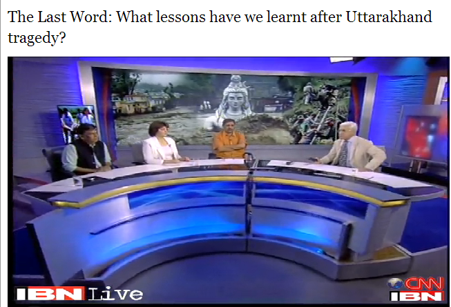
“In a state like Uttarakhand, which is prone to disasters like cloud bursts, flash floods, land slides, the indiscriminate building of hundreds of hydropower projects in this state, each project entailing dam, tunnels that need to be blasted through, the roads, townships and deforestation, the disaster and damage potential goes up multi fold, particularly when there are no credible environment of social impact assessments at project or basin leve, nor any carrying capacity study, nor any credible compliance mechanisms. Even the wrong operation of projects can add to the disaster potential.” http://ibnlive.in.com/news/uttarakhand-needs-proper-weather-forecast-mechanism-himanshu-thakkar/400084-3-243.html

“The South Asia Network on Dams, Rivers and People (SANDRP) says too many hydropower projects, underground tunnels, roads, encroachments of riverbeds by buildings coupled with deforestation could have worsened the impact of the flash floods.

“We do not have credible environmental-impact assessment of infrastructure projects on these highly ecologically sensitive areas,” says Himanshu Thakkar of SANDRP. “Neither is there any credible mechanism to assure compliance with environmental regulations. These are places where there is a heavy tourist influx. The collapse of buildings like a set of playing cards shows these were encroachments on the riverbed and floodplains.”

Thakkar says there have been seven similar flood-related disasters in Rudraprayag in the last 34 years. “The administration should have learnt,” he says. “This is not the first time such a disaster has hit us. Both Uttarkashi and the Chamoli-Rudraprayag-Kedarnath area faced monsoon disasters last year, killing several people. There are a few hundred hydropower projects, for instance, in the various tributaries of the Ganga here. These may all be legal projects approved by the environment and forests ministry but have a serious bearing on the flow of the river.”http://timesofindia.indiatimes.com/india/Unchecked-infrastructure-projects-made-it-worse-in-Uttarakhand/articleshow/20673047.cms

In conclusion:

Managing disasters after they occur is at a huge human, ecological and economic cost. Predicting and controlling disasters transparently and swiftly is a crucial factor.It is clear that numerous organisations, groups, individuals, even government institutions had raised the issue of impacts of cascade hydel dams on Upper Ganga on Hydrology, Ecology and Communities in this fragile region. Most of the suggestions have been ignored.

Even gazette notification of 135 kms of Bhagirathi as an Eco sensitive Zone came in pretty late from the MoEF and is being opposed by the Uttarakhand Government.

The responsibility of the current calamity does not rest alone with Uttarakhand Government or Disaster Management unit. It lies squarely also with the MoWR, Ministry of Environment and Forests and the Prime Minister, who is the chairperson of the National Ganga River Basin Authority. Incidentally, the MoEF has been sitting on Draft River Regulation Zone Notification for more than 3 years now. The RRZ Notification could have helped in controlling infrastructure development like hotels and homes along the river.

At the cost of hundreds of lives, the current disaster is a bitter lesson for us. It is not a time to engage in a blame game of whether or not this is a man made disaster. The contributing reasons like Dams, tunnelling, blasting, mining are well known; History of projects on Assiganga and Dhauliganga is well know and so is the topographical, seismological, geological fargility of the region. It is now a time to act and actually implement recommendations given by so many committees and organisations since past many years.

Climate Change is no longer a distant, obscure event, it is in front of us now.

In keeping with all these factors, there is an urgent need to immediately stop the ongoing hydel projects in Uttarakhand, address pending issues raised by communities and groups, undertake transparent and true carrying capacity study of the region, scrap 24 projects mentioned by WII and more, considering geological impacts, monitor commissioned projects closely for compliance, decommission commissioned projects whihc flout environmental norms or have a severe downstream impact, manage 135 kms Ecosenstive zone on bhagirathi, have a similar one for Alaknanda and near all river origins in Uttarakhand.

When faced with a human toll that is feared to be close to a thousand, hydel power does not seem so bright or clean, green and sustainable like it is touted. It is not something for which India can risk the lives and well-being of its population or environment.

Himanshu Thakkar, Parineeta Dandekar

Useful Links:

1. For an account of Floods in Pithoragarh district of Uttarakhand, see: http://www.himalprakriti.org/?q=content/brief-report-spate-along-gori-river-basin-north-eastern-kumaon-uttarakhand-15th-17th-june; images of the Goriganga floods: http://www.himalprakriti.org/?q=content/images-gori-spate-june-2013; Before and after images of 5 Motighat hydropower project: http://www.himalprakriti.org/?q=content/and-after-images-uttarakhand-floods-2013

2. For a photo feature on damage to Vishnuprayag HEP, see: http://matuganga.blogspot.in/

3. For an excellent account of how Uttarakhand is a model of disaster, see: http://tehelka.com/uttarakhand-a-model-of-disaster/

4. Uttarakhand Disaster Mitigation and Management Centre: http://dmmc.uk.gov.in/

5. National Disaster Management Authority: http://ndma.gov.in/ndma/index.htm

6. National Institute of Disaster Management: http://nidm.gov.in/default.asp

7. India Meteorological Department: http://imd.gov.in/

8. Flood forecasting site of Central Water Commission: http://www.india-water.com/ffs/index.htm

9. Sphere India website, coordinating disaster management from non govt agencies: http://www.sphereindia.org.in/

10. People Science Institute: http://peoplesscienceinstitute.org/Appeal-UD…html

11. Action Aid: http://www.actionaid.org/india

Dams · Hydropower · Ministry of Environment and Forests

Naseeruddin Shah extends support to bold new film on the Ganga

Legendary actor Naseeruddin Shah has extended his support and presence in the film Return of the Ganga, a bold new 3-part documentary film that explores the recent ongoing mad chaotic tension between conservation and exploitation of our land, water and people.

ReturnofGanga

At the heart of the film is the river Ganga being dammed extensively and dried up. The film explores the options we have to save Ganga from over 600 hydro-power projects being built on her. It introspects why for the first time in the 5000-year history of our civilisation, we are facing the death of our very lifeline. Return of the Ganga also explores our choices against the backdrop of vast sweeping global changes. It makes a strong case for clean and renewable energy options and how we can get out and get our act together to ensure good sustainable sense prevails all around and especially in the corridors of power.

Naseeruddin Shah connected with filmmakers Marthand and Valli Bindana and agreed to anchor and narrate in the film. He was moved and affected by the issue and consistent with his effort to support new adventurous filmmakers, extended his involvement. Marthand and Valli are first-time filmmakers and have been working on the project since October 2012. A largely self-funded venture, the film made by this incorrigible 2-person crew, is heading towards completion the end of September. The filmmakers are looking for distribution channels.

Return of the Ganga brings people living by the river in remote regions of the Himalayas, environmentalists, scientists,  renewable and solar energy experts, sadhus, politicians, Indian and international activists all together on a single platform discussing policies and demanding change. Change that will ensure conservation of our priceless natural habitats, and environments.

Featuring in the film are people who have been working in the field for decades – Himanshu Thakkar, Vandana Shiva, Rajendra Singh, MC Mehta, Harish Hande, GD Agarwal, Shivanand, Vinod Tare. International activists also throw in their weight behind this effort with Mark Dubois: River Activist, Tony Seba: author of Solar Trillions, Jason Rainey: Executive Director International Rivers and Brad Meikle: Expert on German clean energy policy. The crew is also trying to involve Union Ministers of Power, Environment and Renewables. Some have been reluctant to speak about this very hotly debated topic.

A short rough trailer can be seen here – http://returnoftheganga.com/

Cumulative Impact Assessment · Dams · Environment Impact Assessment · Hydropower · Ministry of Environment and Forests · Western Ghats

Comments on HLWG Report submitted to Ministry of Environment and Forests

This post is based on a submission made by SANDRP and our colleagues on the HLWG Report on Western Ghats. 20th May 2013 is the last date to submit comments on this. Comments need to be sent to: amit.love@nic.in. We request groups and individuals to make as many submissions as possible.

Comments on HLWG Report with a focus on Water issues

Date: May 20, 2013

To,


Mrs. Jayanthi Natarajan

Union Minister of State (IC)

Ministry of Environment and Forests

Government of India

Email: mosefgoi@nic.in, jayanthi.n@sansad.nic.in


Dr. V Rajagopalan

Secretary

Ministry of Environment and Forests

Government of India

Email: envisect@nic.in


Dr. Amit Love,

Deputy Director,

Ministry of Environment and Forests

Email: amit.love@nic.in


Dear Mrs. Jayanthi Natarajan and Dr. Rajagopalan,


SUB: Comments on the High Level Working Group Report with respect to water sector

This is in response to announcement posted on MoEF website about submitting comments on the HLWG report under the Chairpersonship of Dr. Kasturirangan. These comments mainly deal with water in Western Ghats: One of the most critical issues for Western Ghats States.

A lady collecting drinking water from a sacred grove in Western Ghats Photo: SANDRP

Unfortunately, we have to note that recommendations of the HLWG Committee in response to WGEEP Report as well as some of HLWGs omissions and commissions are detrimental to the well-being of rivers, wetlands and dependent communities in the Western Ghats and hence, for related sectors like ecology, water supply, irrigation, hydropower, etc. This is elucidated in the following points:

  1. HLWG does not comment on any other issue related to water except hydropower:

While the Gujarat, Maharashtra, Goa, Karnataka, Kerala and Tamilnadu are facing multiple issues with respect to rivers, drinking water, irrigation, loss of biodiversity and livelihoods, dam-induced displacement, etc., the only issue HLWG report has commented upon is Hydropower. The WGEEP report has dealt with a number of issues related to the water sector from democratic community driven bottom up governance, watershed development, opposition to large dams in ESZ I and II, drinking water, fisheries, etc. However, the HLWG does not comment on any of these recommendations of the WGEEP, nor does it offer its own position on these. This is a serious lacuna in the HLWG Report.

In the absence of such recommendations, we request that MoEF adheres to WGEEP recommendations.

Fishing in Vashishthi Estuary, Western Ghats. Photo: SANDRP
  1. HLWGs recommendations about Hydropower are ad hoc, unscientific and misleading
  1. HLWG claims that all Hydropower is “renewable and clean.”

This is a completely incorrect statement and it’s surprising to see that it comes from HLWG. The world over, the myth of Hydropower as clean source of energy has been busted.[1],[2] Hydropower projects have huge impacts on environment, ecology, forests, rivers, biodiversity and livelihood security of the people. Studies have proved that methane emissions from reservoirs formed by hydropower dams in tropical countries can have significant global warming potential, methane being about 21 times more potent global warming gas than CO2. Dams emit methane at every draw down.[3] With tropical forests in the Western Ghats (WG) under submergence and otherwise destruction by such projects, this threat is even more serious. Already WG has some of the biggest hydropower plants in the country including the Koyna, Bhandardara, Ghatghat HEPs and three Tata HEPs in Maharashtra, Linganmakki, Gerisouppa, Bhadra, Tungabhadra, Upper Tunga, Talakalale, Kabini, Harangi, Chakra, Supa, Varahi, HEPs in Karnataka, Idukki, ldamalayar, Lower Periyar, Poringalkuttu, Sholayar HEPs in Kerala and Bhavani HEPs in Tamil Nadu. All these projects have not only contributed to greenhouse gas emissions, but have also adversely affected communities, forests, rivers and ecosystems in Western Ghats. There are numerous pending cases of rehabilitation from these dams (for example Koyna in Maharashtra) till date involving tens of thousands of people and communities in many areas are still suffering from erratic water releases from these projects (downstream communities near Jog Falls d/s Linganmakki).

Hydropower dams in WG are in many cases transferring water across the basin for power generation, making it unavailable of the original basin and its inhabitants (For example:  Interbasin transfers from Koyna and Tata Hydropower dams in Maharashtra). Every hydropower project has finite life. Thus, for the basin dwellers and everyone else, Hydropower not much renewable either.

 HLWG is not justified in giving a ‘clean and renewable’ certificate to hydropower.

Jog Falls on Sharavathy: Dried and diverted by the Linganmakki HEP in Karnataka Western Ghats. Photo: SANDRP


  1. HLWG allows Hydropower projects in ESAs while not looking at performance of existing projects

While the WGEEP did not allow large dams and hydropower projects in ESZ I and II, HLWG has allowed hydropower projects in its demarcated ESAs. This is unacceptable. Western Ghats are already ravaged by dams and at least the areas of high biodiversity value should now be protected from the same onslaught. But the HLWG has rejected WGEEP recommendations about this. While doing so, they have not looked at the performance of the existing HEPs in WG. SANDRP has been studying performance of HEPS in India for some time now based on generation data from Central Electricity Authority. The performance of existing hydropower plants in WG is dismal as can be seen below:

  • In Koyna Basin, the per MW generation in 2010-11 has dropped by a huge 56.79% from the highest per MW generation achieved in the year 1994-95.[4]
  • In Kali Nadi projects, the per MW generation has dropped by 46.65% from the highest per MW generation achieved in 1994-95[5]
  • In Sharavathi Basin projects, per MW generation in 2010-11 has dropped by 37.60% from the highest per MW generation achieved in the year 1994-95[6]
  • Same situation is true for most other hydropower projects.
  • Most of these projects are performing far below the level at which the projects were given techno-economic clearances.
  • There is no assessment as to how much of the generation from such hydropower projects is during peaking hours. Nor is there any attempt at optimising the peaking power from these projects.

It is clear that there is huge scope to make the existing projects more efficient, rather than destroying ESAs in WG with more projects.

We request that in line with WGEEP report, large dams should not be permitted in ESAs of Western Ghats.

  1. Recommendation about mitigating impacts of Hydropower are extremely weak
  • The HLWG has recommended 30 % of lean season flow as the minimum flow throughout the year as a conditionality for allowing hydro power projects in the ESA. This is contradictory to the recommendation for ecological flows by the HLWG.  Ecological flows means trying to mimic the natural flow regime in the river as far as possible and that would include arriving at different seasonal flows based on studies and consultation with the river communities and other stakeholders, using the Building Block Methodology which even the Inter Ministerial Group on Ganga Basin has said is the most appropriate for India. Moreover, the IMG has recommended 50% releases in lean season flows, applicable for all existing projects. MoEF should accept these norms immediately for all existing projects.

The MoEF should be recommending ecological flows / environmental flows as in the WGEEP report and not minimum environmental flows and this should be determined through holistic methodologies like Building Block Methodology and local participation.

  • The HLWG recommendation of 3 km minimum distance between dams is totally ad hoc, arbitrary and hence unacceptable. Firstly, the HLWG should have mentioned min 3 km of flowing river between projects. The minimum distance is river specific and would depend upon a basin level study of the river including the altitudinal profile of the river, the riparian forest status, the aquatic habitats and biodiversity, the present dependability and many such criteria. More significantly, the cascade hydropower dam menace which is destroying rives in Himalayas need not be replicated in western ghats. We would like to reiterate that no large dams should be allowed in the ESA of WG.

The MoEF should recommend for arriving at river specific studies while accepting 5 km of free flowing river between projects as minimum distance of free flowing river between projects. The best case is not to allow any further large dams in Western Ghats.


No flows in Sharavathy downstream Linganmakki  Dam and Jog Falls. Photo: SANDRP
No flows in Sharavathy downstream Linganmakki Dam and Jog Falls. Photo: SANDRP


  1. The HLWG does not stress the need for Environmental Clearance for Mini hydel Projects

Hydro projects less than 25 MW are currently exempt from Environmental Clearance due to a dangerous omission in the EIA Notification 2006. WG is currently facing a severe threat due to a flood of these unplanned cascades of Mini Hydel Projects. Ecosystems and communities in rivers like Netravathi, Kumaradhara, Krishna and Cauvery are facing impacts of these projects, many of which are fraudulent.[7] Netravathi has more than 44 mini hydel projects planned and under operation. Kerala has plans to set up  around 100 mini Hydel projects on its rivers. The threat of these projects on river systems in Western Ghats is so high that in March 2013, the Karnataka High Court, has banned any new mini hydel projects in Karnataka Western Ghats[8].

WGEEP had recommended no mini hydel projects in ESZ I and II. HLWG has not done this. While the HLWG makes a rather vague statementThere is a need to redesign and reevaluate small hydropower projects – below 25 mw as these often have limited impact on energy generation and can lead to huge impacts on ecology’, it has not recommended that these projects should need an EIA and EC process, like it has said for Wind Energy. This is a very serious omission. SANDRP and many organizations have written about this to the MoEF several times.

The MoEF should amend the EIA Notification 2006 and include all hydel projects above 1 MW in its purview.


Pristine Forests set for submergence under the 24 MW Kukke Mini hydel Plant in Dakshin Kannada, Karnataka. Photo: SANDRP
  1. The HLWG does not stress the need of Environmental Clearance (EC) for Drinking Water and Industrial supply dams

HLWG has not looked at water as a sector, but has only confined itself to hydropower. This has resulted in several loopholes. Many dams are being constructed in Western Ghats for Drinking Water and Industrial water supply. These are also exempt from EC process as per the EIA Notification 2006. Dams like Kalu, Shai, Balganga, Khargihill, Pinjal, Gargai are set to submerge more than 6000 hectares of forest in ESAs and Protected Areas in Northern Western Ghats in Maharashtra.

WGEEP Report had recommended no large dams in ESZ I and II, but the HLWG does not talk about these dams at all. Their impacts on WG forests and communities are entirely ignored. This is another serious lapse of the HLWG report.

The MOEF should amend the EIA Notification 2006 to include all large dams, irrespective of the purpose, including drinking and industrial water supply dams in its purview. No large dams should be planned in ESA of Western Ghats.


Ravines of Vaitarna already submerged by the Middle Vaitarna Dam near Mumbai Photo: SANDRP
  1. HLWG does not recommend eflows from existing projects

Several hundreds of Irrigation, water supply, hydropower dams have transformed the nature of rivers and dependent communities in Western Ghats. While the WGEEP Report mentioned maintaining eflows from existing projects, the HLWG does not make any recommendation for eflows from existing projects.

Hydropower projects in Karnataka like Kali, Linganmakki have affected communities and ecosystems in the region, have driven some species to extinction. There is an urgent need to restore eflows in all WG rivers.

The MoEF should recommend that eflows should be assessed with holistic and participatory methodology like BBM and recommend e-flows for all dammed rivers in Western Ghats with time limit of one year.

  1. HLWG does not apply its mind to dam decommissioning

The HLWG has chosen to ignore the recommendations on dam decommissioning. While the states have rejected the recommendation the MoP (Ministry of Power) and Central Electricity Authority has noted that dam decommissioning in a phased manner is worth considering.

There are several irrigation and hydropower dams in the Western Ghats which are severely underperforming or incomplete after two decades, or more than 100 years old, and/or unsafe. For example, several experts have opined than large irrigation projects in Konkan region of Maharashtra are severely underutilized. Tillari Interstate Project between Maharshatra and Goa which has come up affecting a wildlife corridor and which has still not rehabilitated its affected population, has a created irrigation potential of 7,295 hectares in Maharashtra of which farmers are utilizing just 162 hectares, according to the Govt Of Maharashtra’s 2012 White Paper on Irrigation Projects in Maharashtra. This underlines the redundancy of large irrigation projects in the WG.

The HLWG had an opportunity to relook at such projects, which it has not done. The HLWG could have noted that the state governments and the MoEF and MoP should start the process of evolving parameters / criteria towards the process of dam decommissioning.

The MoEF may please recommend the same.

Leaking Khadkhad dam Mahrashtra Western Ghats Photo: Pune Mirror


  1. HLWG does not recommend free flowing rivers for WG

Rivers in Western Ghats are repositories of biological, ecological and cultural diversity. Rivers in WG harbor high endemism and diversity in freshwater fish. They also house several Sacred groves at river origins, river fish sanctuaries, etc., protecting rivers and fish. The freshwater biodiversity remains the most fragmented among all biodiversity and HLWG has taken no note of this state and further risks that freshwater biodiversity faces. The WGEEP had wisely followed a graded approach in tune with the ecological connectivity of river ecosystems. ln the HLWG approach, stretches of rivers would flow out of the natural landscape into the cultural landscape which is open to indiscriminate development and the chance for their restoration or protection would be completely lost out. A river cannot be protected in pieces like this.

Looking at the pressures from dams and water abstractions, there in an urgent need to conserve ecologically, culturally and socially important rivers in their free-flowing condition. This approach is well accepted globally and several countries have created specific legislations for protecting free flowing rivers[9]. It seems that the IMG Committee on Upper Ganga, in which Ms. Sunita Narain (Member of Kasturirangan Committee), was also a member has recommended that some six tributaries of Upper Ganga basin should be kept in pristine state. While rejecting WGEEPs recommendation about dam decommissioning or dam free rivers in the ESZs, HLWG has not recommended keeping even a single river in Western Ghats in its free flowing condition.

MoEF should identify ecologically, culturally and socially important rivers, based on community and ecological knowledge and conserve Heritage Rivers of Western Ghats in their free flowing condition for the current and future generations.


Seetha Nadi, free flowing river in Karnataka Western Ghats. Photo: SANDRP
  1. HLWG allows Inter basin transfers in Western Ghats, without any justification or studies

The HLWG has agreed to inter basin transfers toeing the claims of some of the states. There are ample instances of failed interstate – inter basin transfers in the Western Ghats rivers which have turned into permanent scenes of conflicts like the famous Mullaperiyar,  Parambikulam Aliyar, Siruvani interstate inter basin transfers between Kerala and Tamil Nadu. The HLWG while acknowledging the need for ‘ecological flows assessment’ in rivers has failed to note that in all these inter basin transfers, the river / tributary has been completely diverted and has lost its ‘ecological flows’. The HLWG could have recommended a cumulative impact assessment of the existing inter basin transfers which would reveal the ground reality.

HLWG seems to have accepted the contention of states like Maharashtra: “This (stopping IBT) would be a problem, they explained, as many regions of the Western Ghats lie in the rain shadow area and need water to be diverted for irrigation and drinking.”

Reality is that, ALL the interbasin transfers happening in Maharashtra currently (through Koyna and Tata Hydro power projects, an amount more than 4 Billion Cubic Meters Annually) are transferring water FROM the rain shadow area of Krishna and Bhima basins TO water surplus regions in Konkan. If HLWG was concerned about water supply for rain shadow regions, it would have at least recommended that this transfer from deficit area to high rainfall area be immediately reviewed and reversed in a time bound manner. It has chosen not to, showing its complete ignorance of ground reality or its completely pro government and pro vested interests bias.

The MoEF should retain the recommendation for no more inter basin transfers as in the WGEEP report and ask for immediate review of transfer of water from deficit basins to high rainfall areas. 


  1. HLWG allows hydro projects in first and second order streams

The HLWG has not said no to hydro power projects in first and second order streams in ESA. Meanwhile the MoP, CEA and WAPCOS all agree that hydro power projects should not be permitted in these highly ecologically sensitive areas which are the ‘origin’ of Western Ghats Rivers.

The MoEF should retain the recommendation for no run of the river schemes in first and second order streams as in the WGEEP report.

  1. HLWG offers no comments of on several water sector recommendations of WGEEP which have been supported by State Governments

Kerala and Maharashtra have accepted many of the recommendations of the WGEEP in water sector (page 14 section 2.3 – point 9) like catchment area treatment plan, protection of high altitude valley swamps, water conservation measures, rehabilitation of mined areas, improved river flows etc. It is surprising to note that the HLWG is silent on these very important measures and has not even endorsed these acceptable recommendations which can significantly contribute towards improving water availability in the Western Ghats.

The MoEF should follow these recommendations of the WGEEP.

  1. HLWG takes an extremely biased stand about Athirappilly and Gundia Hydropower projects, rejected by the WGEEP

The WGEEP had categorically stated that the Athirappilly and Gundia Hydropower project should not come up in Western Ghats, looking at their huge impacts on biodiversity, several studies by local organisations and local opposition. However, ignoring all these, the HLWG has taken a very pro project stand on these projects, stating that they can be considered with some vaguely due process, which the state government would be happy to show they have followed it on paper. This is entirely unacceptable.

The MoEF should not allow Athirappilly and Gundia HEPs looking their impact on ecology and communities and in face of the strong local opposition that they are facing.

DSC02831
Athirappilly Waterfalls on the Chalakudy River Photo; SANDRP

The WGEEP process and report initiated a robust discussion about the paradigm of development and conservation in Western Ghats. Water and Rivers is a cross cutting issue connecting ecosystems and communities, rural areas and urban centers, providing goods and services and supporting freshwater biodiversity, which is most threatened currently.

A proactive position on conserving rivers in Western Ghats will go a long way in protecting and conserving myriad livelihoods and ecosystems that thus depend of them.

We hope the MoEF considers the recommendations made above about the WGEEP and HLWG Reports and helps conserving rivers of the Western Ghats for people and ecosystems urgently. The HLWG Report cannot be accepted the way it stands presently. As a step in this direction, we also suggest that WGEEP should get a formal chance to respond to the points raised about it in the HLWG.

Thanking You,


Yours Sincerely,

Himanshu Thakkar, Parineeta Dandekar, South Asia Network on Dams, Rivers and People, New Delhi and Pune (ht.sandrp@gmail.com , parineeta.dandekar@gmail.com)

Dr. Latha Anantha, River Research Centre, Thrissur, Kerala (rrckerala@gmail.com)

Shripad Dharmadhikary, Manthan Adhyayan Kendra, Pune, Maharashtra (manthan.shripad@gmail.com)

Dr. T.V. Ramchandra, Energy & Wetlands Research Group, Centre for Ecological Sciences, IISc, Bangalore (cestvr@ces.iisc.ernet.in)

Janak Daftari, jalbirdari, Mumbai, Maharashtra (daffy@jalsangrah.org)

Sujit Patwardhan, Parisar, Pune, Maharashtra (patwardhan.sujit@gmail.com)

Dr. Nilesh Heda, Samvardhan, Vidarbha, Maharashtra (nilheda@gmail.com)

Nisarg Prakash, Nature Conservation Foundation and Nityata Foundation, Bangalore, Karnataka (nisargprakash@gmail.com)

Mrinalinee Vanarase, Iora Consultants, Pune, Maharashtra (ioraespune@gmail.com)

Shankar Pujari, President, Nivara Bandhkam Kamgar Sangh, Sangli, Maharashtra (shankarpujari16@gmail.com)

Damodar Pujari, SANDRP, Pune, Maharashtra (damodar.sandrp@gmail.com)

Saili Palande-Datar, Kalpavriksha, Pune, Maharashtra

Following Members from Energy and Wetlands Research Group, Centre for ecological Science, Indian Institute of Sciences: 

  • Dr. M.D. Subash Chandran
  • Dr. Prakash Mesta
  • Dr. Uttam Kumar
  • G R Rao
  • Mahima Bhat
  • Vishnu Mukri
  • Sreekanth Naik
  • Balachandran C
  • Boominathan M
  • Bharath H Aithal
  • Bharath Settur
  • Vinay S
  • Ganesh Hegde
  • Anindita Dasgupta
  • Arun D T
  • Vishnu Bajpai
  • Gouri Kulkarni
  • Sudarshan Bhat
  • Durga Madhab Mahapatra
  • Ashwath Naik
  • Sowmya Rao
  • Shwetmala


International Water Issues

Latest meeting of Committee of Secretaries: Govt of India pushes unviable hydro projects in North East Without due process

Latest meeting of Committee of Secretaries

Govt of India pushes unviable hydro projects in North East

Without due process


In a recently held meeting (see the latest updates on this issue from http://www.energylineindia.com/ on this below), the Committee of Secretaries have pushed for large hydro power projects in Arunachal Pradesh. As the agitation against the under construction 2000 MW Subansiri Lower HEP on Arunchal Pradesh border has shown any such move, without credible, independent and comprehensive options assessment, social and environmental impact assessment at project and basin level in a transparent and democratic way would prove to be disastrous not just from social and environment point of view, but also from economic aspects. Hurrying through such projects in the name of establishing prior use rights in the name of Chinese projects in Brahmaputra basin would not be helpful. The fact that the river and its ecology are in use by the people of Arunachal Pradesh, Assam, other North East and east India states, Bhutan and Bangladesh should be sufficient if prior use was indeed a tenable argument in international context.


Some new facts that have come to light from the CoS meet include:

  • According to the 9th report of the Inter-Ministerial Expert Group (IMEG), discussed during the course of the meeting, there has been an increase of three project sites on the mighty river since IMEG’s last report, prepared a few months earlier. A total of 39 Rune of the River projects/sites are now present on Brahmaputra and its tributaries.
  • Dam related peripheral infrastructural activity has gathered speed at Lengda, Zhongda and Langzhen, which are on the main course of Siang or Yarlung Tsangpo as it is called in Tibet. The Bome-Medog road which passes through the Great Bend Area is also being upgraded. The Joint Secretary, Ministry of External Affairs said that keeping in mind China’s bad track record to resolve water disputes, he was of the opinion that India should cooperate with other countries facing similar issues with China.
  • This report suggests that no instance of water diversion activities is discerned on the main course of the river and its tributaries.
  • Jiacha could be the next hydroelectric project on the mainstream of Brahmaputra River. It may be followed by hydroelectric projects at Lengda, Zhongda, Langzhen, where dam related peripheral infrastructural activity (including 4 new bridges) has gathered speed.
  • Dagu and Jiexu projects, which are also on the main course of Brahmaputra River, along with Nangxian project may see considerable development activity in future.
  • The China is carrying out series of cascading ROR projects in the· middle reaches of Brahmaputra, the same may be replicated in the Great Bend Area as a viable alternative to a single mega project and this needs further monitoring.
  • The CoS has directed the Technical Expert Group (TEG) to submit its action plan for establishing India’s user right within a month’s time. Cabinet Secretary directed TEG to submit a blueprint for action with indicative time lines within a month. CoS has recommended Additional Secretary, Ministry of Power to chair the TEG. Notably, the TEG along with other standing groups like IMEG, will continue to submit their six monthly reports.


Unfortunately, none of the reports of the TEG or IMEG are in public domain, nor are they available under RTI Act. The people of north east are kept in complete darkness about the decisions these officials take.


About the projects in the NE India, the CoS meeting noted:

  • Special Secretary, Water Resources, stated that 92 HEPs (above 25 MW) with aggregate capacity of 36,272.5 MW have been allotted of which about 20 are at some progressive stage of development.
  • While for 11 HEPs, aggregate capacity of 8,510 MW, the detail project reports (DPRs) have been submitted to CEA for examination, 9 projects worth 10,570 MW have been concurred by CEA.
  • In the case of Pashighat (2700MW) project, Techno Economic Clearance has been received and public hearing is scheduled next month.
  • Indeed as SANDRP analysis of functioning of EAC shows, the Expert Approval Committee has said yes to the largest of projects from Arunachal Pradesh.


An important agenda of the CoS meeting was to assess the progress of the measures suggested by the committee in its 4th meeting held on April 26, 2011. The committee had directed a Joint Steering Committee consisting of representatives from NHPC and Assam government to end the long standing deadlock at the 2,000 MW Subansiri HEP. Notably, the Joint Steering Committee has submitted its report in July 2012. In response to the CoS decision that Ministry of External Affairs (MEA) should firm up views on the modalities of initiating a more informed public debate on the issue of the Brahmaputra water diversion, MEA and MoWR have formed a joint mechanism to pursue the same. An FAQ has also been prepared on the subject to disseminate awareness. Apart from this, MoWR has initiated action on the decision of the CoS to hold informal discussion between concerned ministries for constructing multipurpose projects in Arunachal Pradesh. An inter-ministerial informal discussion was held in October 2011. An outcome of the meeting was that discussion of rehabilitation, an issue hampering many projects, should be project specific. Further, the Planning Commission has formed an Expert Panel to take up the sub-basin wise Environmental Impact Assessment (EIA) study under the chair of Chairman CWC which will submit its report this month.


Many of these actions of CoS and other related bodies clearly lack credibility. The Central Water Commission itself largely acts like a lobby for big dams in India and it is never known to have taken any credible steps for environment or EIA. Under the circumstances, the sub basin wise study that is expected from CWC would not have any credibility.


South Asia Network on Dams, Rivers & People (www.sandrp.in)


Some recent postings on this issue:
1.
http://tehelka.com/a-damned-race-for-power/#

2. https://sandrp.wordpress.com/2013/02/09/cutting-off-nose-to-spite-the-face-whose-nose-and-whose-face/

3. https://sandrp.wordpress.com/2013/02/11/india-pushing-for-a-water-treaty-with-china/

4. http://www.thehindu.com/news/national/expert-group-calls-for-monitoring-chinas-runoftheriver-projects/article4599260.ece

Dams

PEOPLES’ CONSULTATION ON DAMS & NATURAL RESOURCES IN NORTH EAST

10-11 FEBRUARY 2013, AGARTALA, TRIPURA

The participants of the Two Day “Indigenous Peoples Consultation on Dams and Natural Resources Protection in India’s North East”, held at Agartala from 10 till 11 February 2013, organized by the Borok Peoples Human Rights Organization, Committee on the Protection of Natural Resources in Manipur, North East Dialogue Forum, Citizens Concern for Dams and Development, Siang Peoples Forum, Mapithel Dam Affected Villagers Organization, Peoples Movement for Subansiri Valley, Civil Society Women’s Organization, All Loktak Lake Areas Fishermen Union, Affected Citizens of Teesta, Centre for Research and Advocacy, Save Sikkim, Initiative for Human Rights and Indigenous Peoples, Peoples’ Right to Information and Development Implementing Society of Mizoram, Federation of Khasi, Jaintia and Garo People, All Assam Students Union, Save Mon Federation, All Zeliangrong Students Union, Hmar Inpui United Committee on the Protection of Natural Resources, All Tribal Students Union Manipur, Manab Adhikar Sangram Samiti, Naga Women’s Union hereby:

Asserts that the land, forests, rivers and all natural resources in India’s North East belongs to the indigenous peoples of the region. Our land and all natural resources are inherent sources for our life, culture, identify, survival and future of our present and coming generations.

Further affirms that the indigenous peoples in the region have the right to self determination over our land, territory and resources possessing undeniable rights over its management and use.

Expresses our concern with the introduction of more than 200 mega dams and other unsustainable development policies and projects in the region without the free prior and informed consent of indigenous peoples in the region

Asserts that mega dam constructions already commissioned such as Loktak Project in Manipur, Dumbur Dam in Tripura has already led to widespread dispossession, loss of land, extinction of flora and fauna, demographic impacts on indigenous peoples in the region and other human rights violations.

Taking note of the ongoing and aggressive construction of mega dams such as 2700 MW Lower Siang HEP, 3000 MW Dibang HEP, 1750 MW Lower Demwe in Arunachal Pradesh, 1200 MW Teesta III HEP, 500 MW Teesta IV HEP, 97 MW Tashiding HEP, 280 MW Panang HEP etc in Sikkim, 1500 MW Tipaimukh HEP, 7.5 MW Mapithel Dam in Manipur, 2000 MW Lower Subansiri HEP, 600 MW Kameng HEP in Arunachal Pradesh which has already led to widespread dispossession, environment devastations, militarization, conflicts and human rights violations

Seriously concerned with the projection of mega dams in India’s NE as climate friendly and seeking carbon credits and profits by dam developers from CDM mechanisms of UNFCCC Concerned further with increasing corporatization of our land and resources and the aggressive efforts to explore and drill oil in the region by corporate bodies, such as oil exploration efforts by Jubilant Energy in Manipur, Gas exploration in Tripura by ONGC, to mine uranium in Meghalaya by UCIL, etc.

Concerned with the increasing militarization of indigenous peoples land while pursuing mega dams and other extractive industries and the complication of conflicts by the destructive development processes and subsequent human rights violations:

Concerned with the increasing involvement of international financial institutions, such as World Bank, Asian Development Bank, the Japanese Bank for International Cooperation etc in financing energy and water related projects and in deregulation of related policies to intensify corporatization of our land and resources Concerned with the Government of India’s non application of the UN Declaration on the Rights of Indigenous Peoples, 2007 and the recommendations of other UN human Rights bodies, such as the UN Special Rapporteur on Indigenous Peoples and UN Committee on the Elimination of Racial Discrimination in 2007 and September 2011 to respect indigenous peoples’ rights

Recall the obligations of all states to ensure participatory forms of development and to recognize indigenous peoples rights as reflected in the outcome of the UN Rio+20 conference, June 2012.

Calls upon the Government of India and corporate bodies:

• The Government of India and all corporate bodies should respect and recognize indigenous peoples’ rights over our land and resources in India’s North East and also to respect and recognize their self determined development processes in the region.

• Implement the UN Declaration on the Rights of Indigenous Peoples, 2007 and recommendations of all UN human rights bodies in all development processes affecting their land and resources. • Decommission Dumbur HEP project in Tripura and Loktak Multipurpose Hydroelectric Project in Manipur

• Revoke all MoUs, Environment Clearances for mega dams in the region, especially for 2700 MW Lower Siang HEP, 3000 MW Dibang HEP, 1750 MW Lower Demwe in Arunachal Pradesh, 1200 MW Teesta III HEP, 500 MW Teesta IV HEP, 97 MW Tashiding HEP, 280 MW Panang HEP etc in Sikkim, 1500 MW Tipaimukh HEP, 4000 MW Etalin HEP, 2000 MW Lower Subansiri HEP, 600 MW Kameng HEP etc, granted in the region despite peoples vehement objections and also without their consent.

• Conduct a full review of Mapithel Dam construction and other ongoing mega dams constructions for their compliance with social, environment and human rights norms and safeguards as laid down by the World Commission on Dams, UN Indigenous Peoples Declaration, other human rights treaties and as reflected in “The Future, We Want”, the outcome document of the Rio+20 in June 2012.

• Stop all false projection of Mega Dams as Climate Change friendly in NE India

• Oppose all bilateral or multilateral secretive agreements and negotiations among States on water and energy issues in India’s North East, especially between India and Bangladesh

• Stop all Uranium mining in Meghalaya, Oil exploration efforts in Manipur without the free, prior and informed consent of indigenous peoples.

• Ensure that all International Financial Institutions, World Bank, Asian Development Bank, Japanese Bank for International Cooperation etc investing in India’s North East in water, energy, forestry sector etc should respect indigenous peoples’ rights as per the UN Indigenous Peoples Declaration.

• Repeal Armed Forces Special Powers Act, 1958 and stop all militarization processes associated with development processes in India’s North East

• Protect the human rights of environmentalists, human rights defenders, dam activists campaigning for just and sustainable development in the region We committed to support and extend solidarity to all initiatives and efforts of the indigenous peoples of NE region to assert our right to self determination over our land, wetlands and rivers, forests and all resources and to define our development priorities based on our needs, wishes and aspirations.

Dams

Jan 2013 issue of “Dams, Rivers & People”

Highlights of  the Jan 2013 issue
Jan-Feb Issue of Dams, Rivers and People
As “Dams, Rivers & People” completes ten years, we are happy to bring it to you in brand new format. Please do let us know how you like it.

Analysis of MOEF’s EAC on RVP: The Expert ApprovalCommittee

The Ministry of Environment & forest (MoEF) has constituted different Expert Appraisal Committees (EAC) for the appraisal of various developmental projects including River Valley & Hydroelectric projects. The Union Ministry of Environment and Forests’ (MoEF) Expert Appraisal Committee (EAC) on River Valley and Hydroelectric Projects (RVP) has not rejected a single one of the 262 hydropower and irrigation projects considered by it. This is one of the clues that EAC has strong pro project and anti people bias

Nyamjang Chu

MoEF’s EAC on River Valley Projects:Project wise details (April 2007 to Dec 2012)

This document presents decisions of meetings of the EAC during the period from Apr 2007 to Dec 2012. The document is organized region wise, then statewise, and finally as per project. This list provides evidence for the information provided in the lead article about the functioning of the EAC.

Man holding a Mahseer

Freshwater Biodiversity Conservation finds place in Indian Biodiversity Congress!

Indian Biodiversity Congress lays stress on Freshwater Biodiversity conservation. Looking at the huge and at time irreversible impact of dams and hydropower projects on aquatic and terrestrial biodiversity, Indian Biodiversity Congress has made some specific recommendations to the MoEF

People protesting against Luhri HEP

Reject Environment Clearance for the proposed 775 MW Luhri hydropower project

This letter to the MOEF draws attention to the many inconsistencies in the EAC’s approval of this project on the Sutlej River. It points out that the EIA is ‘inadequate, full of contradictions and misrepresentations’ and recommends blacklisting of the agency involved

Photo of plants in a wetland

Include rivers in India’s definition of Wetlands, follow the Ramsar Convention

The Ramsar Definition of wetlands includes permanent, seasonal, and intermittent Rivers.Despite this, Wetlands (Conservation and Management) Rules 2010 EXCLUDE Rivers from the definition of Wetlands, thus ensuring that no riverine stretches will be nominated for protection.

South Asia Network on Dams Rivers and People

Related News: 

You are receiving this email because you have subscribed to ‘Dams, Rivers and People’
Our mailing address is:

SANDRP

Kanchanban

Pune 411 038

India

Add us to your address book

Email Marketing Powered by MailChimp