Environment Impact Assessment · Interlinking of RIvers

Why Ken Betwa EIA by AFCL is unacceptable

The Environmental Impact Assessment (EIA) of Ken Betwa Riverlink project used for the public hearing to be held on Dec 23 (Silon village in Chhatarpur district) and Dec 27 (Hinouta village in Panna district), 2014 in Madhya Pradesh is, as can be seen from the details below, unscientific, incomplete, inadequate, biased, inconsistent (self contradictory), callous, making unwarranted conclusions/ assumptions, it accepts government claims uncritically and is generally a shoddy piece of work.

For violations involved in public hearing, see our earlier blog[1].

Background Agriculture Finance Corporation of India (now AFC Ltd) was commissioned in 2007 itself to conduct Environmental Impact Assessment (EIA) of Ken Betwa Riverlink proposal. This was even before National Water Development Agency (NWDA, a society of Government of India created in 1981-82 exclusively for studies on River Linking proposals) applied for the Terms of Reference Clearance for the EIA for this project in December 2010.

This review of the EIA of Ken Betwa project is based on the Executive Summary (English) of the EIA made available on the Madhya Pradesh Pollution Control Board (MPPCB) website in Dec 2014 before the statutory public hearing slated for Dec 23, 2014 at Silon village in Chhatarpur district and Dec 27, 2014 at Hinouta village in Panna district, both in Madhya Pradesh.

Since this executive summary is largely the same as the EIA made available to the Expert Committee set up on Inter Linking of Rivers (ILR) by the then Union Ministry of Water Resources (now Union Ministry of River Development, Ganga Rejuvenation and Water Resources – MRDGR&WR) for which I was a member, I have also provided the critique of that earlier EIA (in red font) in Annexure 1 to this Article[2].

The comments given below under each heading are only indicative to establish what is contended about the EIA here and not exhaustive.

Biased EIA In the very second paragraph of the EIA Executive summary[3], it is stated, referring to NWDA studies, “These studies established that Betwa is a water short basin”. But an EIA is not supposed to uncritically accept such assertions or assumption of the developer. In fact the EIA accepts this as gospel truth without critically examining it.

Incomplete EIA The EIA executive summary does not even have a project layout map, sections like biodiversity impact assessment, impact of destruction of substantial part of Panna Tiger Reserve, surrounding forests and livelihoods of the people dependent there on, options assessment, hydrological viability assessment, disaster potential assessment, how the project will be impacted by destruction of forests and climate change, additional green house gas emissions due to the project and downstream impacts, to name just a few issues..

EIA makes wrong claims The EIA claims in very second paragraph: “The scope of EIA studies inter-alia does not include water balance studies.” This is a wrong claim since water balance study of the Ken Betwa links establishes the hydrological viability of the project and by not going into the water balance study, the EIA has failed to establish hydrological viability of the project. SANDRP analysis in 2005[4] of the NWDA feasibility study of Ken Betwa Proposal[5] had established that the hydrological balance study of the Link Project is flawed and an exercise in manipulation to show that Ken has surplus water and Betwa is deficit.

As the collector of Panna district noted in 2005 itself[6], if the 19633 sq km catchment of the Ken river upstream of the proposed Daudhan dam (comprising areas of eight districts: Panna, Chhatarpur, Sagar, Damoh, Satna, Narsinghpur, Katni, and Raisen) were to use the local water options optimally, then there will not be any surplus seen in Ken river at the Daudhan dam site and by going ahead with the Ken Betwa Link without exhausting the water use potential of Ken catchment, which is predominantly a tribal area, the government is planning to keep this area permanently backward. But the EIA of Ken Betwa link does not even go into this issue, making the whole exercise incomplete.

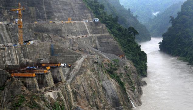
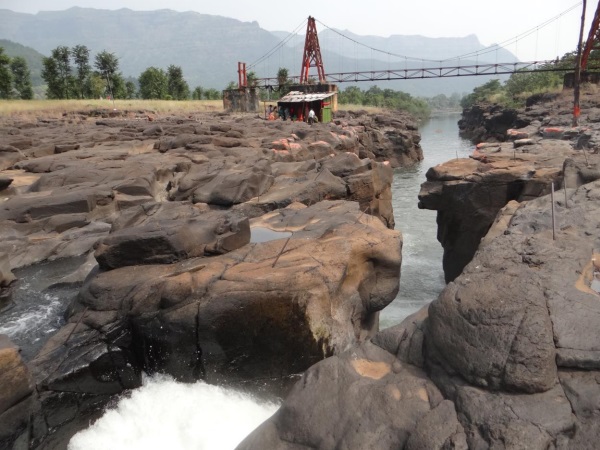
Ken Betwa project destroys Panna Tiger Reserve but EIA claims project may benefit PTR! The Ken Betwa Project, as per the EIA, will submerge 4141 ha of Panna Tiger Park reserve, but the EIA Ex Summary says (para 58), “the reservoir may prevent encroachments of the park and invasion by livestock so that a relatively more secure and compact habitat is formed on Right flank of Daudhan dam which may be beneficial.”

In Para 63, the EIA executive summary goes on to claim that the project will not decrease tourists flow (due to destruction of Panna Tiger Reserve or drying of waterfalls in the downstream), but in fact increase tourist inflow because of the creation of reservoir! No word about the destruction of river!!

Absence of credible submergence figures The EIA has hugely reduced the area to be affected in Panna Tiger Reserve and in the surrounding forests compared to the figures given in the Feasibility report of the project, without any explanation. Well known conservation expert Kishore Rithe, in his article in December 2014 issue of Sanctuary Asia Magazine has raised doubts about these figures and has suggested that much larger area will be destroyed by the project than what is stated in the EIA. He has also said that the EIA does not take into account the biodiversity that will be destroyed in the forest because of the project. Using strong (& justified) words, he has said this is assassination of wildlife, to help the contractors.

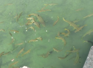
EIA LIES on Biodiversity: Endangered and vulnerable species in Ken Basin find no mention in EIA Para 59 of the Ex Summary of EIA is about Aquatic Environment and it says: None of the species of aquatic plants come either under rare or endangered or endemic or threatened categories (REET). This is a shocking lie, since the following paper by Dr.K.D Joshi and B.K. Biswas of CIFRI (Central Inland Fisheries Research Institute) says that the Ken has at least 4 endangered and 9 vulnerable species. The EIA is also keeps mum about the existence of Ken Ghariyal Sanctuary in the downstream area, which will be destroyed due to the project.

CIFRI paper of 2010 said there are 4 endangered and 9 vulnerable fish species in Ken River According to a paper by Dr. K. D. Joshi and B. K. Biswas published in Journal of Inland Fisheries Society of India (42(2): 25-31, 2010) titled Piscine Diversity and Fisheries in the River Ken, proposed for the Inter-River Linking, “53 fish species classified under 40 genera, 19 families and 7 orders. Out of these, 51 species are native and 2 exotic. The river comprises some highly important threatened species including 4 endangered and 9 vulnerable species… The fish species available in the river have immense economic importance”.

Endangered species include: Tor tor (Mahseer), Chitala chitala, Eutropiichthys vacha, Ompok pabda.

Vulnerable (VU) species: 1. Gonialosa manmina 2. Catla catla 3. Puntius sarana sarana 4. Rhinomugil corsula 5. Mystus bleekeri 6. Clarias batrachus 7. Heteropneustes fossilis 8. Clupisoma garua 9. Bagarius bagarius

The paper concludes that the proposed Ken Betwa link project will have “Deleterious impacts on piscine diversity and fishery may occur downstream to the Daudhan dam site in the river Ken, as a result of the depletion in breeding and feeding grounds and hiding sites of the fishes. This could be due to reduction in flow as a result of diversion of the water to the Ken-Betwa link.” The EIA has no word on this.

GEM of the EIA: Project canals help fish migration and will provide a ‘short cut’ for fish! This is indeed a GEM from the EIA executive summary. In para 59 the EIA executive summary says: “Interlinking of these basins through link canal will facilitate rapid migration of the fish easier… The fish has a tendency to migrate upstream. The inter linking of rivers provide another route for fish migration from Yamuna to Betwa and ultimately from Betwa to Ken. Further, the distance from Duadhan dam to the place of confluence of Ken with Yamuna is longer as compared to the distance from the place of confluence of Betwa with Yamuna and Daudhan dam through link canal. Thus, this route will facilitate rapid migration of fish.” This shows shocking ecological illiteracy of the EIA consultants. This para not only shows how poor is their understanding of fish, rivers and ecosystems, it also shows by AFCL should be blacklisted from doing any EIAs.

ANOTHER GEM FROM EIA: RESERVOIRS HELP REDUCE POLLUTION! In para 61 the EIA Ex Summary says: “Stagnated body can get rid of their pollutants by sedimentation while lotic body carries its load of pollutants downwards.” This narration of advantages of stored water as against flowing river clearly seems like a prescription that it is better to dam the river to reduce pollution! Another example ecological illiteracy of the EIA consultants.

Incomplete EMP The Environment Management Plan (EMP) in the EIA ex summary starting from para 66 is incomplete: It does not include environment flow assessment, muck disposal plan, compensatory afforestation plan, Compensatory land allocation for destruction of Panna Tiger Reserve, habitat improvement plan for the balance part of PTR, REET species plan mentioned in para 70(c) at cost of Rs 10 crores, upstream (of Daudhan Dam) water development impacts/ management plan, downstream impacts management, to mention only a few.

Outdated R&R Plan norms As stated in Paras 76 onwards, R&R (Resettlement and Rehabilitation) plan has been prepared based on norms of National R&R Policy of 2007 and MP R&R policy of 2002, but both are outdated in Dec 2014 where the applicable norms are based on The Right to Fair Compensation and Transparency in Land Acquisition, Rehabilitation and Resettlement Act, 2013. Thus the whole R&R plan is completely outdated and will need fresh assessment starting from Social Impact Assessment. The whole EIA has no mention of settlement of rights under Forest Rights Act. Thus the whole social impact and R&R section is outdated, incomplete and under estimated and hence unacceptable.

Fundamental contradictions in R&R figures Para 80 of EIA ex Summary says that 1585 families will be affected by the Daudhan Reservoir. In next para, this becomes population of 1585! Two paras latter, in para 83, the population affected by the reservoir becomes 7224! In para 92 the EIA executive summary says: “Therefore it is only 806 project affected families and there are no other affected families in the project affected villages.” This not only shows contradictions but absolute callousness of the EIA agency.

EIA says minimum agriculture wage is Rs 64/-! In para 94 the EIA executive summary says all the entitlement has been assessed based on agriculture wage rate or Rs 64/- of 2006-07! This is when the minimum agricultural wage rates for unskilled labourers w.e.f. 01.04.2014 is Rs 193[7], more than three times the rate assumed by EIA agency!

Joke of Land for Land by providing 5% of acquired land Para 96 of EIA Ex summary says that total of 6423 ha of revenue land is acquired and it is proposed to provide land for land to ST and SC families. Than it says for this purpose, a total of 358 ha of land will be required! This comes to 5.57% of acquired land and the EIA consultant says this is sufficient for providing land for land! This is clearly a cruel joke on the ST and SC families and shows how great an impoverishment programme this project is.

Social & Environmental impacts of backwater effect not assessed Para 67(c) says that 956 ha of land will be affected due to back water impact, but there is no social and environmental impact assessment of the back water impacts.

Contradictions in EMP

  • Para 59 says there are no REET species, and para 70(c) provides Rs 10 crores for REET species plan!
  • Para 70(a) says fisheries production from reservoir will be 470 MT / year and para 70(e) says the same will be 60 tons!
  • In para 70(a) the EMP says the reservoir fisheries will provide livelihood for 500 families and also that there will be sport licensing.

Questions over choice of AFCL for Ken Betwa EIA The Ken Betwa EIA work has been given to Agriculture Finance Corporation Ltd. (now AFC Ltd – http://afcindia.org.in/). Firstly, the basic mandate of this corporation is Agriculture Finance, and as we all know agriculture finance is in bad shape in India, one of the major reason for the agrarian crisis. In stead of focusing on its core area, this corporation has been majorly working on preparation of Environment Impact Assessment related work. Why should the government encourage such non core work by AFCL, [AFCL is itself is a quasi government body, it being owned by NABARD and EXIM bank]? Secondly, the track record of AFCL in EIA related work is quite bad. Some of the recent EIAs of AFCL that has invited adverse remarks include the EIA of Polavaram Multipurpose project (also one of the ILR links), Tipaimukh project in Manipur, Kameng Hydropower project in Arunachal Pradesh and Thoubal irrigation project in Manipur. In case of Tipaimukh and Polavaram EIAs, even some of the official agencies have found their EIAs to be wanting.

For example, the minutes of the minutes of the meeting of the Expert Appraisal Committee of the MoEF&CC for River Valley Projects, held on Oct 15, 2007 said that the EIA report for the Tipaimukh (even after several revisions spread over several years) “The revised EIA report incorporating the above mentioned information was considered by the committee in its meeting held on 15th October 2007. After careful examination of the report, the committee was of the opinion that the report has been prepared haphazardly… As such the data reported (flora and fauna) is of little value… No fresh study (on water quality) has been undertaken… No mention has been made about as to how many water bodies (ponds, lakes, Jheels, springs, etc.) are going to  be submerged by the dam and what type of flora and fauna available there… The Biodiversity Management Plan as well as Fishery Management Plan are not up to the mark. Separate plan for rehabilitating the riverine species should be done. Fishery Management Plan does not say anything as to how measures will be taken for the conservation of the fish fauna occurring in the region. Instead, it talks about cultivation of economically important fish… Plan for the Biodiversity Management also needs significant improvement. IVI should be calculated for dominant species. Nothing has been said about the rehabilitation of mahseer (and similar other species), in spite of its endangered nature. The Financial outlay for both the plans has been prepared just as an eye wash and need thorough revision and enhancement of at least ten to fifteen times. The Biodiversity Management Plan is also having very small financial outlay. This also needs significant enhancement.” (Emphasis added.)

Cover Photo of B Tech paper by Chandan Bhavnani

CONCLUSION This analysis clearly shows that the EIA consultant does not have basic understanding of ecological issues related to rivers or river valley projects, ground situation in project area or laws of India. This EIA is clearly unacceptable and should be rejected. The EIA should be re-commissioned to a credible EIA agency. Appropriate steps should be taken against the current EIA consultants. The public hearing planned on Dec 23 and 27, 2014 should be cancelled as there is no basis for conducting an informed public consultation. This EIA and also the public hearing conducted based on this EIA will not stand public, scientific, social or legal scrutiny.

Himanshu Thakkar, SANDRP (ht.sandrp@gmail.com)

ANNEXURE 1: EIA CRITIQUE OF APRIL 2010: 

Ken Betwa River Link EIA from NWDA received in November 2009

WHY THIS EIA IS NOT ACCEPTABLE 

This is in response to NWDA letter No.: NWDA(SCILR)/Tech-1/200/3/2006 (Vol.X)/67-86 Dated 23.3.10, requesting expert committee members to submit comments on the DRAFT Ken Betwa EIA, a soft copy of which was sent to the committee members in Nov 2009.

EIA AGENCY IS BIASED

  • In the very second para of the executive summary, EIA says Betwa is “Water short”. EIA agency is supposed to be unbiased and cannot parrot the assumptions of the developing agency, NWDA.
  • In para 1.02 (chaper 1, volume 1), it says, “It is noted that dams with reservoirs are among measures mostly resorted to as long term solution to mitigate flood losses as well as to prevent drought situations.” This is completely wrong statement, with no basis in reality, and in any case shows the bias of the agency at the outset.
  • In para 1.16 it says, “The anticipated benefits of the project include the following. The transfer of water to deficient areas from surplus areas;…” This clearly shows that the EIA agency has uncritically accepted the conclusion of the project developer, without so much as even an attempt to assess its correctness. How can such an agency be accepted as an objective EIA agency?
  • In Para17 it says, “There is no other alternative for irrigating the proposed CCA of about 3.436 lakh hectares, providing drinking water facilities to 16.98 lakh population and generating 78 MW power. This project is inevitable for removal of the backwardness and poverty of this Bundelkhand region of Madhya Pradesh. The no project option will adversely affect the development of this backward region of Bundelkhand and thereby increase the regional disparities. Such disparities contribute for large scale migrations from and unrest in the region. Therefore, no project option is an alternative to be considered.” Here again we can see the clear and repeated bias of the EIA agency. Firstly, the EIA agency does not even say what is the no project alternative. Secondly, it assumes that the project would remove the backwardness and poverty of the Bundelkhand region of MP, without any substantiation. Lastly, it says, no project option is to be considered!!! What does it mean??

EIA AGENCY IS INCOMPETENT

  • In para 14 of the Exe Sum, it says, “Out of the above, forest land accounts for to 5258 ha, rest of the area being agricultural lands, settlements, scrubs and water bodies. Ten villages are likely to be submerged. Area of Panna national park or Tiger reserve accounts for about 65.13 percent of total forest area under submergence with 4163 ha.” Simple calculation shows that 4163 is 79.2% of 5258, and not 65.13% as stated by the EIA. The EIA also does not explain why the forest land has reduced from 6400 ha in Feasibility report to 5258 ha and area of Panna tiger resevee has come down from 4586 ha in FR to 4163 ha now.
  • In Para 56 the EIA says, “The area (Daudhan project) under irreversible impacts is neither a home nor an important habit for the wildlife including birds”. To say this when the project is going to submerge over 4600 ha of Panna Tiger Reserve is shocking.
  • In para 58 EIA says, “Interlinking of these basins through link canal will facilitate rapid migration of the fish easier.” How can this become possible?
  • In Para 60 EIA says, “Stagnated body can get rid of their pollutants by sedimentation”. This is clearly wrong.
  • In Para 73 EIA says, “The budget for different management activities required to be carried out for mitigation and prevention of dam break is 60 lakh.”, However, none of the measures listed there can prevent dam break.
  • In para 1.04 it says, “In the nineteenth century British colonialism introduced technical and hydraulic principle by introducing perennial irrigation in the sub-continent… A third wave in hydraulic manipulation emerged in 1930s with new technologies put into operation to effect the virtual industrialization of river control. Now the entire river basin had become the focus for water planners and engineers. This facilitated to train the river through interconnected dams, reservoirs and diversions all the way to its estuary by harnessing its waters simultaneously for navigation, irrigation, flood control and power generation.” These statements make no sense and in any case are irrelevant and also show the ecological illiteracy of the agency and also its bias for such systems.
  • In para 1.10 it says, “The Gangau weir was constructed to augment supplies from Bariapur PUW for transferring the water from Ken basin to Betwa basin, as the construction of a reservoir is proposed at Daudhan village in Chhatarpur district. Before selecting the Daudhan site for construction of a reservoir, an assessment of two other alternative sites were considered.” Makes no sense. There are many other such paras and statements, but these samples should be good enough for any objective reader.
  • In Para 1.18 it says, “National Water Development Agency, New Delhi taken up feasibility studies of Ken-Betwa Link Project in Madhya Pradesh to cater to the needs of irrigation besides providing drinking water, power generation and diversion of waters to Betwa basin. Though there are large benefits that may accrue after assuring irrigation they are out weighed by social, environmental and economic costs.” (Emphasis supplied.) If the benefits are out weighed by the costs, than the project is non viable is it not? Why that conclusion is then not reflected in the rest of the report?

EIA INCOMPLETE

  • In para 66 (under Reservoir Rim Treatment) the EIA says, “The periphery line beyond the MWL will be in submerged condition for a few days only during flood period and will be vacant during other period.” No details are given as to how much area of which specific villages/ districts will be affected over how much period and what will be the impacts thereof.

EIA DRAWS UNWARRANTED CONCLUSIONS/ ASSUMPTIONS

  • Para 26 of Exec Sum says, “Due to drying up of leaves of trees, monkeys were found moving from one tree to another for their shelter in Panna Park near proposed Daudhan dam.”
  • In Para 40 it says, “Hence impact due to change in the hydrological cycle are not anticipated.” This is completely wrong, the hydrological cycle will change with the building of the dam and there will be impacts there of.
  • In Para 57 it says, “The Daudhan reservoir is capable of effecting the distribution of Tigers since the Tiger reserve of 4163 ha (National Park) will be submerged. But at the same time, the reservoir may prevent encroachments of the park and invasion by livestock so that a relatively more secure and compact habitat is formed on Right flank of Daudhan dam which may be beneficial.” There is no obvious logic to what the EIA says here.
  • In Para (on growth of aquatic weeds in reservoir) 59 it says, “The problems are manageable through bio-manipulation of reservoirs.” How can that be achieved and what will be consequences?
  • In Para 62 it says, “There are no places of tourist interest going to be affected due to the submergence.” This when the Daudhan dam will submerge over 4500 ha of Panna Tiger reserve, which is obviously a place of tourist interest.
  • In Para 66 (under compensatory afforestation) it says, “Assuming that non forest land is not available…” when the EIA is not supposed to make such assumptions.
  • In Para 69 the EIA talks about development of fisheries in Daudhan reservoir, without understanding that the most of the reservoir will remain under the forest dept and tiger reserve and such activities are not allowed in reserve area.

EIA MAKES CONTRADICORY STATEMENTS

  • In Para 69 the EIA says, “Funds to a tune of 1000 lakh are required for conservation of REET species in the submergence area.” However, earlier in para 57 it says, “…impact of the projects on REET species may not be too severe to prevent any recovery.” And in para 58 it says, “None of the species of aquatic plants comes either under rare or endangered or endemic or threatened categories (REET).”
  • In Para 69(a) the EIA says, “There is a proposal to develop carp based fisheries in Daudhan reservoir with an anticipated production of 470 MT/ year” and in para 69(e) it says, “Fish production from the reservoir will be increased steadily on a sustainable basis to attain a yield of 60 tones on full development by adopting the measures suggested.”

EIA AGENCY IS CARELESS

  • The EIA in para 34 says, “The Daudhan dam and reservoir area comprises of very hard, compact and dense quartz – arsenate”, but does not give any implications of the presence of dangerous Arsenate compound. According to Wikipedia, “An arsenate(compound) is any compound that contains this (AsO43−) ion.”[1]
  • The EIA says (para 4) that the Full reservoir Level is 288 m. When the FRL in FR was 287 m, the EIA should explain this change. It also claims that the MWL will be same as FRL, which is also a change from FR, no explanation is given.

EIA AGENCY USES WRONG TERMS

  • In para 39 it says, “No change in the regime of Ken River due to Daudhan dam or Betwa river due to Makodia dam is anticipated.” The line or the para does not explain what is meant by regime of river. If it means flood regime, since the para is talking about floods, its conclusion that there will be no change is completely WRONG. Such big reservoirs would completely change the flood regime downstream from the dams.

EIA Provisions are inadequate

  • In Para 91 the EIA provides for “Provision of land to land to the extent of land acquired, to the ST and SC PAFs.”. However this is completely inadequate. If the displaced population of Sardar Sarovar Dam from the same state of MP are entitled for minimum of 5 acres of irrigated land, why should the displaced population of Ken Betwa get anything less? All displaced families must get at least this.
  • The EIA does not indicate the R&R plan for the canal and other categories of displaced. This is also not acceptable. All categories of displaced must be treated the same way.
  • The R&R plan does not ensure improved and permanent livelihood for the displacement population. It also does not take into account the total resource base of the affected population, without which one cannot even assess if the affected people are better off or not.

THE EIA PROVIDES NO REFERENCES OR NAMES OF THE SOURCES OR EXPERTS IT USES IN THE REPORT. THIS MAKES SUCH FIGURES AND STATEMENTS UNVERIFIABLE AND HENCE UNRELIABLE.

The EIA also does not address many of the issues I raised following the earlier version of the EIA shared with the expert committee, this is pretty shocking too.

This brief note is sufficient to show why the current EIA for the Ken Betwa link proposal is unacceptable and the best course of action would be to go for a fresh EIA with a more credible agency. Pl include this note in the agenda of the 9th meeting of expert committee on ILR. This is not an exhaustive comment, but provides sufficient reason to reject this EIA and commission a fresh EIA from a credible agency, in consultation with the Expert Committee.

March 31, 2010, South Asia Network on Dams, Rivers & People (www.sandrp.in)

END NOTES:

[1] http://en.wikipedia.org/wiki/Arsenate, accessed on March 5, 2010

[1] https://sandrp.wordpress.com/2014/12/20/violations-in-ken-betwa-riverlink-public-hearings-in-last-week-of-2014/

[2] https://sandrp.in/riverlinking/Why_Ken_Betwa%20_EIA_is_unacceptable_April_2010.pdf

[3] http://www.mppcb.nic.in/pdf/594-English.pdf and http://www.mppcb.nic.in/pdf/594-hindi.pdf

[4] https://sandrp.in/riverlinking/knbtwalink.pdf

[5] http://nwda.gov.in/index4.asp?ssslid=35&subsubsublinkid=22&langid=1

[6] http://www.hindustantimes.com/india-news/madhyapradesh/mp-pays-the-price-but-up-to-corner-benefits-of-river-linking-project/article1-1261741.aspx

[7] http://clc.gov.in/estb/pdf/miniwage2.pdf

Beas · Himachal Pradesh

Larji Dam Fishladder: an unlovely trinket, a deceptive ornament

Emmanuel Theophilus[1] (etheophilus@gmail.com)

The 126 MW Larji Hydropower project near Aut on the mainstem of the Beas is run by the Himachal Pradesh State Electricity Board (HPSEB)[2]. The dam is constructed a little downstream of the confluence of the two main tributaries upstream, the Sainj and the Tirthan, at the narrowest part of a spectacular gorge, towering with limestone cliffs. The impounded waters of this dam have, since its construction in 2006, drowned the access road to the entire upper Kullu valley including Manali and the hundreds of villages upstream, including access to the entire Lahul valley and the region of Ladakh over the high passes from this end. The HPSEB then constructed a 3 km long tunnel to enable passage of traffic, and many people have warned of the hazardous nature of the tunnel. The 220 odd gods that descend from different valleys, on the backs of people to the lower Kullu valley every year in autumn however, refuse to use this tunnel. This is what compelled the HPSEB to build and maintain this tunnel, and during autumn to winter, to keep the water-storage in the dam low to enable the passage of gods, who have been traveling this route for over three and a half centuries. It is remark-worthy though, that this dam constructed as recently as 2006, seems to be heavily silted-up already and the dark shadows of sediment-shoals are visible just below the waters of the reservoir[3].

Being among the most recently completed, the Larji dam is the only dam on the Beas that has a fish-ladder, so it was of particular interest to us. Seeing no guard at the security booth, we walk in to the HPSEB dam operating office, and ask to speak to an officer about the fish ladder. To our complete surprise, we are spoken to and even taken on a tour of the ladder by a foreman who has worked on the dam for many years.

Having seen an elaborate fish ladder on the Kuri Chhu river in Bhutan of doubtful effectiveness[4], we could not help but look at this one with hope and excitement. Located at around 1,000 meters altitude, this dam was clearly in the way of a host of migratory species of fish. If this ladder design was effective, then surely the ‘barrier’ problem to seasonal migration for breeding and dispersal would have been addressed. Here though, is what we saw and heard.

  1. For one, the flow through the fish-pass seems too small to create an ‘attraction flow’ for fish. But even more obviously, the downstream entrance of the fish ladder is a steep cascade over a couple of meters of broken masonry and rock, that would clearly be un-negotiable by any fish that does not jump that high[5].
Downstream entrance of Larji fish ladder: The 2 m high jump that fish require to enter the ladder can be seen here
Downstream entrance of Larji fish ladder: The 2 m high jump that fish require to enter the ladder can be seen here (all photos by the author)

2. The outlet from the dam reservoir into the fish ladder is blocked off by a metal grill-mesh that is narrow enough to trap flotsam like Bisleri water-bottles. The mesh seemed too fine to let Mahseer of breeding-age pass through, either upstream or downstream.

3. The fish ladder was in a serious state of disrepair. To our questions about whether the ladder worked or not, the foreman says honestly that it does not. We see the reasons for this when we walk down the ̴100 meter length of the fish-pass channel.

Fishladder can be seen in serious state of disrepair and blocked by broken concrete parts can be seen here

4. The Larji fish ladder seemed to be a hash of different designs of fish passes. There were four different design elements in this one fish-pass. It had a slotted-weir fishway design, a low gradient Denil fishway, a steep-pass Denil fishway and a plain concrete culvert on a grade design. Most of these slotted weirs were clogged with fallen rocks and debris from the slope above, and in places, the pools in them were over-flowing the weir in a vertical fall almost 2 meters high.

Steep-pass Denil fishway part of the fishladder can be seen here, water is flowing too rapidly here for any fish to be able to go upstream
Steep-pass Denil fishway part of the fishladder can be seen here, water is flowing too rapidly here for any fish to be able to go upstream. The water picks up momentum down an extremely steep slope with the baffles at 45 degrees to the flow, not offset to slow the water, but concentrating the force of the water in mid-stream flow. The slope seemed to be at almost 40 degrees angle, and the water was turbulent in the extreme in this section. A workable Denilway slope, even for the strongest of swimmers among fish, is not designed to exceed a slope of 20% at most. This was close to a 100% slope

5. The oblique baffles on a Denil fishway are supposed to be placed in a manner that provides staggered partial-obstructions that slow the water down at variable velocities to make it passable for fish. However, here we saw that the water picks up momentum down an extremely steep slope with the baffles at 45 degrees to the flow, not offset to slow the water, but concentrating the force of the water in mid-stream flow. The slope seemed to be at almost 40 degrees angle, and the water was turbulent in the extreme in this section. A workable Denilway slope, even for the strongest of swimmers among fish, is not designed to exceed a slope of 20% at most. This was close to a 100% slope[6].

This part of fish ladder is less steep Denil

The last part of the fishway was a plain concrete culvert on a grade channel, essentially a sloping channel, where even the concrete sides of the channel had toppled over into the river-bed, and the final drop was over a two meter fall into the downstream flow. I asked the foreman whether he knew whether fish managed to make it over this extreme gauntlet. He said that they did not, but that he often saw fish gather and concentrate at the bottom of the dam under the sluice gates, and make futile leaps in an attempt to get over the dam. Clearly, the Larji dam fish ladder is just an unlovely trinket, a deceptive ornament.

Watch a 41 seconds video showing how fast the water is moving through the Larji Dam fishladder at: http://youtu.be/grVaxXPdeyY, Video is by the author.

It seemed to me that the dam builders and operators, the HPSEB in this case, both at the design and the executive levels, were not serious about constructing a fish-pass that would work, and neither were they serious about this at the operation and maintenance aspects. Whether they were serious at all even at the conceptual level, to put in place a mitigation measure that actually helped migratory fish bye-pass the barrier of the dam, or was this part of the design merely to obtain environmental clearance, can only be conjectured about. That hydropower projects can devise deceitful strategies for obtaining environmental clearance is one thing, but what does this tell us about the Union Ministry of Environment and Forests, the Expert Appraisal Committee on River Valley Projects appointed by MoEF, the regional office of the MoEF, the state Fisheries Department and also the state pollution Control Board, who are all variously part of the approval processes for hydropower projects, when they get their environmental clearances based on such ‘mitigation measures’?

Larji Dam - about 100 m long fishladder channel can be seen on the right side
Larji Dam – about 100 m long fishladder channel can be seen on the right side

END NOTES:

[1] This article has been extracted from SANDRP’s publication: Headwater Extinctions: Hydropower projects in the Himalayan reaches of the Ganga and the Beas: A closer look at impacts on fish and river ecosystems, authored by Emmanuel Theophilus, for details, see: https://sandrp.wordpress.com/2014/12/16/new-publication-headwater-extinctions-impact-of-hydropower-projects-on-fish-and-river-ecosystems-in-upper-ganga-and-beas-basins/

[2] The 126 MW Larji project is also infamous for being the costliest hydro-power project per unit electricity generated so far in India. Finally built at a cost of R.s 10.27 billion, which was twice the estimated cost, the Vigilance department unearthed major financial misappropriation by HPSEB officials.

[3] The Larji Dam became infamous in June 2014 when 25 students were washed away downstream from the dam due to sudden and unannounced release of water from the dam, see: https://sandrp.wordpress.com/2014/06/12/nadiya-bairi-bhayi/

[4] https://sandrp.wordpress.com/2014/02/02/fish-ladder-at-kurichhu-hydropower-project-bhutan-some-thoughts/

[5] Other than loaches, those tiny finger sized fish that can even climb (squiggle technique) up high waterfalls, provided there is something like a water-slide at the margins of the fall. They however, are not migratory fish.

[6] CIFRI recommends that the speed of flow of water in a fish-pass should not exceed 2 meters per second. Please see ‘Status of fish migration and fish passes with special reference to India’. MK Das and MA Hassan. CIFRI 2008.

Himachal Pradesh

The Socio-Ecological Effects of Small Hydropower Development in Himachal Pradesh

J. Mark Baker (JMark.Baker@humboldt.edu), Humboldt State University, Arcata, CA, USA

Introduction

This article is part one of a two part summary of the results of a study on the socio-ecological impacts of privatized, small, run-of-the-river hydropower projects in Himachal Pradesh.[1]  It is based on field research conducted in 2012 on all 49 commissioned small hydropower projects in the state.

Map 1

In the late 1990s Himachal Pradesh, as did other states in this region, launched a series of initiatives to privatize and promote small hydropower production (Sinclair 2003).  In 2006 these initiatives were incorporated into a new hydropower policy that aimed to generate revenue through the sale of surplus power to neighboring states and to promote the state’s own development (GoHP 2006).  Because the levels of investment necessary to develop hydropower exceed the state’s financial resources as claimed by the policy, Himachal Pradesh’s power policy provides for private sector involvement and uses central government subsidies.  Small hydropower project construction and operation in Himachal Pradesh is entirely privatized (GoHP 2006).  Small hydropower projects mostly utilize run-of-the-river power generation technologies to convert hydropower into electricity; this study uses the Himachal Pradesh government definition of small as 5MW or less (though the Government of India defines small as below 25 MW capacity).[2]  By 2012, only six years after the implementation of the policy, there were a total of 49 small hydropower projects generating electricity in the state (including the approximately 8 projects commissioned before 2006) (map 1).  Additionally, approximately 50 more projects were under construction, and approximately 400 were in various stages of planning and approval (GoHP 2012) (map 2).[3]

Map 2

The state established a nodal agency, Himurja, to oversee the private development of the state’s small hydropower potential, and to promote utilization of renewable energy more generally.  In 2006 the state formalized the processes and mechanisms that govern private sector involvement in electricity production by passing the Hydropower Policy.  Himurja plays a central role in this process by allocating government-identified small hydropower project sites to private corporations.  After receiving an allotted project site, the corporation (referred to as the project developer or independent power producer) must prepare a series of detailed project reports that include, for example, two years of streamflow data and analysis of the engineering, economic, hydrological, geological, and environmental characteristics of the project.  Once Himurja officers approve these reports, they and the project developer sign a Memorandum of Understanding, a Techno-Economic Clearance document and eventually an Implementation Agreement.  At that point the developer begins the work of securing the required No Objection Certificates (NOCs) from the relevant state and local government entities including the Wildlife Department, Forest Department, Irrigation and Public Health Department Fisheries Department, Public Works Department, Pollution Control Board, Revenue Department, and affected Panchayats.  After obtaining the required certificates, the power producer may commence project construction.

Construction costs generally range from Rs 6-8 crores per megawatt, but these are quickly recouped through the sale of electricity to the Himachal Pradesh State Electricity Board.  Once the project is commissioned, the HP State Electricity Board guarantees the independent power producer a purchase price of Rs 2.50 per kilowatt hour – the equivalent of approximately Rs 2.2 crores per megawatt per year.[4]  The project reverts to the state government free of cost after 40 years of operation.  The developer pays the state government no power royalties for the first 12 years of the project’s life.  However, for the next 18 years the developer must provide 12% of the power it produces free of charge to the state; for the remaining 10 years it must provide 18% free electricity to the state.

For small hydropower projects, there is no requirement that the project developer prepare a formal environmental and social impact assessment or environmental and social management plan subject to public review.  Nor is the developer required to hold public hearings about the proposed project.  This is a serious issue because the absence of a formal environmental assessment and hearing process prevents members of project-affected communities and other civil society groups from sharing concerns about the projects’ anticipated effects.  This is one of the reasons for the growing and significant level of local opposition to small hydropower development in the state.  A significant amount of the local opposition to small hydropower projects stems from the ways in which such projects disrupt rural livelihoods, combined with the inadequacy of local benefits such as rural employment generation and other forms of direct compensation.  The next sections describe some of the livelihood disruptions the commissioned small hydropower projects have caused.  The discussion is organized district by district, reflecting the geographical pattern of these disruptions.

District Kangra – disruption to local irrigation systems and farmer collective action

The majority of District Kangra lies on the southern side of the Dhaula Dhar mountain range, from where it extends across Kangra Valley and into the Sivalik Hills.  The district is notable for its extensive network of community-managed gravity flow irrigation systems (kuhls).  In Kangra Valley alone 750 large and more than 2100 small kuhls irrigate approximately 40000 hectares (Baker 2005) (figure 1).[5]  Kuhl irrigation water is crucial for both kharif crops (rice and corn) and rabi crops (wheat and potatoes).  These crops, except for potatoes, are almost entirely used for home consumption.  Historically, kuhl irrigation water was essential for driving water-powered mills (gharats) and other machines, as well as irrigating home gardens, watering livestock, and meeting household needs for non-potable water.  The importance of ensuring the continuity of these kuhl irrigation systems is reflected in the language of the No Objection Certificates that project developers must obtain from the Irrigation and Public Health Department as well as from village panchayat pradhans.  These certificates contain language that protects community-managed kuhls from disruptions by small hydropower projects and requires the developer to pay full compensation if a project damages or disrupts a community-managed kuhl.

Fig 1

Despite the protections delineated in the No Objection Certificates, small hydropower projects commonly disrupt kuhl irrigation systems or cause them to cease functioning altogether, either by physically damaging the irrigation system or by diverting the water on which the irrigation system relies (figure 2).  When a kuhl is damaged or deprived of water, farmers must shift to rainfed cultivation.  Output from rainfed crops is invariably much less than for irrigated crops, in part due to unpredictable rainfall, increased vulnerability to drought, and damage from hailstorms at harvest time.  Throughout the state, small hydropower projects have disabled a total of at least 13 kuhl irrigation systems; in none of these cases did the project developer compensate farmers for their losses.  This level of disturbance to irrigation is significant – for example, one of the disabled kuhls was the primary source of irrigation water for approximately 2000 households.

Fig 2

Not all local farmers have not stood by idly, watching the lifeline of their subsistence agricultural economy go dry.  Our research documented countless visits from village representatives to district administrative authorities petitioning them to intercede on their behalf in order to seek redress, compensation, and/or release of adequate water flows necessary for irrigation.  Despite these frequent and often repeated requests, we did not encounter one instance in which the district administration prevailed upon the power producer to either compensate for disruptions to these irrigation systems or reduce water diversion to provide adequate water supply.[6]

Seeing the futility of seeking redress for damage or guaranteed minimum flows from already-constructed projects, farming communities in Kangra have started blocking construction of hydropower projects until the power developer agrees to binding conditions.  One example of this concerns Ganetta Kuhl, which diverts water from the Baner stream and conveys it 22 kilometers to the cultivated lands of more than 500 households in 12 different villages.  The diversion weir for a partially completed small hydropower plant is located upstream of the kuhl’s diversion point.[7]  Farmers worried that the project’s water diversion would reduce the water available to them.  When letters outlining farmers’ concerns sent to Prodigy Hydro Power, the deputy commissioner, and even to the chief minister by the panchayat pradhan and kuhl committee president did not produce results, the irrigators used the threat of opposition and civil disobedience to block further project construction (figure 3).  As a result, project construction work was halted for many months.  Finally, in 2013, the project developer agreed to the farmers’ demands, including that their water rights be guaranteed, and in return the farmers rescinded their threats; construction work on this project is currently underway.

Fig 3

The problems associated with project disruption of traditional irrigation systems are most pronounced in District Kangra due to the large number of kuhl irrigation systems.  However, our research revealed that any location in the state in which kuhl diversion structures are located between a project’s trench weir and tail race were liable to experience water shortages during the year.

Chamba District – landslides, damaged watermills, and local activism

District Chamba lies to the north of District Kangra and contains the headwaters of the Ravi River and key tributaries, all of which have cut deeply into the Himalayan mountains.  Because it lacks the broad arable plains that characterize the kuhl-irrigated Kangra Valley, farmers in Chamba combine rainfed cultivation on terraced fields carved into steep slopes with a high level of dependence on timber and non-timber forest resources, which meet both subsistence needs and generate revenue.  The streams that flow from the forests down through the cultivated fields and villages to eventually join the Ravi River often power 10, 20, or more gharats (water-powered mills).

One of Chamba District’s defining characteristics is its steep topography.  Not only are the roads carved, at times precariously, into steep mountain faces, but there are also numerous signs of natural and human-caused landslides.  In some instances the failure of a terraced field has initiated a landslide whose head swale climbs higher upslope each monsoon season.  In other cases road construction is clearly the culprit, especially where roads traverse steep, unstable slopes or cross ravines that may washout during monsoon storms.

Fig 4

In steep, geologically unstable terrain such as this, small hydropower projects trigger large landslides that not only cause extensive environmental damage but may also damage or destroy the project itself.[8]  The Terailla Project is a case in point.  Located beyond the small town of Tissa in a remote area of Chamba District, this is one of four small hydropower projects that take turns diverting and returning the Terailla River’s water in quick succession.  The power channel of the Terailla Project is carved from a steep, unstable slope containing loose gravel and large rocks and boulders.  After the project was commissioned in 2007, landslides destroyed large sections of the power channel.  Car-size boulders slid downslope and deformed the one meter diameter pipe near the upper end of the power channel (figure 4).  Two other landslides carried large sections of the concrete box power channel down the slope towards the source stream (figure 5).  As of the summer of 2012 this power project had been nonoperational for one year due to the landslide damage.[9]

Fig 5

The upper edge of the growing landslide continues to move upslope and is now destroying the common grazing grounds of the adjacent village; if the rate of the slide’s uphill movement continues, then it will begin approaching the village itself.  Additionally, project roads constructed across adjacent steep slopes to provide access to the diversion weir and to the power house have themselves triggered further landslides.  Despite the clear potential for landslides in this area, the Detailed Project Report submitted by the power developer to HIMURJA states that there is no landslide risk in the project area.  That this faulty assessment was accepted and the project approved suggests there are problems with the government review process.

The four tightly spaced small hydropower projects along the Terailla River have triggered numerous small and large landslides and wrought negative environmental and livelihood impacts.  These include damage to grazing land and cultivated areas, destruction of gharats and other landslide-related damage.  The cumulative negative effects of these projects have generated significant local opposition.  Local community members have protested on numerous occasions and filed multiple court cases against these projects.   Some protesters, including local village women, have been arrested and detained overnight in jail.  The close proximity of these projects along one stream reach raises concerns about the cumulative impacts of clustered small hydropower projects.  This is especially troubling because the project review process contains no mechanism for assessing the cumulative impacts of multiple projects located along the same stream or river.

Damage to gharats from small hydropower projects occurs commonly in Chamba.  Gharats are the most common method for grinding corn, wheat, and occasionally rice.  In exchange for grinding neighbors’ grain, the gharat owner usually receives 10% of the volume of grain they grind.  These in-kind payments support the gharat owner’s family.  Interestingly, in our surveys we found many examples of woman-owned and managed gharats; in most of these cases the woman was either a widow or the head of her household.  Thus gharats are an important livelihood source for this otherwise disadvantaged group of people.

Fig 6

The 49 commissioned small hydropower projects in the state have stopped 104 gharats, either by destroying them due to land and rockslides or by diverting so much water that the gharat had to be abandoned due to lack of water (figures 6 and 7).[10]  The elimination of these 104 gharats weakens the economic stability of the large number of households whose livelihoods they previously sustained.  Although the Irrigation and Public Health Department No Objection Certificate directs the power developer to provide adequate water flows for gharats, the policy contains no requirement that compensation be paid gharat owners if the project damages their gharat or restricts the water available for diversion.  This gap in the hydropower policy, which stems from urban policy makers’ general dismissal and undervaluation of gharats’ importance, suggests why the owners of many of these gharats received no compensation.[11]

Fig 7

Seeing the pattern of uncompensated damage, gharat owners in one stream in Chamba decided on a proactive strategy.  For six months, using threats of direct action against a newly-commissioned small hydropower project, the owners of 12 project-affected gharats stopped the power project from operating until an acceptable compensation agreement was successfully negotiated.  Eventually, through negotiations between the gharat owners, the power developer and the district commissioner, an agreement was reached that ensured acceptable levels of compensation for affected gharat owners.  Based on the assumption that the gharat contributed the equivalent of a daily wage for the household (Rs 120), and the expected life of the power project (40 years), the negotiated settlement consisted of a series of five annual payments which together would total the equivalent of 40 years of daily wage labor.  After the first payment had been made to the concerned gharat owners, they removed their opposition to the project and it began producing and selling electricity.  However, as one gharat owner noted, if their payments cease, they will again stop the project through direct action.

The ability of these gharat owners to successfully engage in direct action and then negotiation reflects the pre-existing patterns of social activism and strong local governance traditions prevalent in Chamba.  Local leaders, inspired by Gandhian ideologies of self-governance and sustainable local livelihoods, have worked to strengthen village panchayat institutions over the last two decades.  This awareness building and social mobilization has centered on defending village community timber and non-timber forest product rights, advocating for community-based medicinal herb collection, and strengthening village level democratic institutions (Gaul 2001).  The resulting awareness and knowledge concerning local rights and democratic process has empowered local communities to defend against livelihood threats, including threats from small hydropower projects.

Kullu District – threats to apple wealth, tourism

Kullu District’s fame, which extends throughout India and indeed the world, stems from a variety of characteristics that also influence the pattern of socio-economic and environmental consequences of small hydropower development.  The district, located to the east of Districts Kangra and Chamba, tends to be relatively wealthy, in part due to the revenue from the cultivation of apples and stone fruit.  Other key sources of local revenues include the film productions that regularly occur in the picturesque mountainous scenery, year-round tourism resulting from Kullu’s attraction to honeymooners and outdoor sports enthusiasts, and Kullu’s prominent pilgrimage destinations, which attract large numbers of pilgrims from throughout north India.  The streams and rivers of Kullu District also support the largest number of private trout farms in the state as well as the Fisheries Department’s fish stocking program, which in turn attracts anglers from around the world and whose efforts are supported by the Himachal Angling Association.  Lastly, parts of the district possess unique ecological and biodiversity values, which conservation efforts within the Forest Department, and especially the creation of the Great Himalaya National Park, seek to conserve and maintain.

The diverse elements of the economic foundations of the district – fruit cultivation, commercial film production, tourism, pilgrimage, fisheries opportunities, and conservation values – also heighten the stakes associated with the proliferation of hydropower projects.  The cumulative impacts of the 11 completed small hydropower projects in the district (with many more under construction and planned) undermine the integrity and value of these elements.

The cumulative effects of transmission line infrastructure threaten the aesthetic and economic values of the Kullu landscape.  As noted previously, private power developers are responsible for constructing power towers and installing transmission lines to convey the electricity they produce to the nearest HPSEB substation.  This is a significant undertaking as the distance between power projects and substations ranges from 3 to 15 kilometers.  When multiple power projects are located in one valley, each must separately construct transmission infrastructure; as the density of power projects increases, so does the resulting network of transmission lines spreading across the picturesque mountain landscape.  Already this density has created negative effects.  Residents we surveyed decried the ugly transmission lines that cut through the fruit orchards in the main Kullu Valley and also traverse the deodar forests and cultivated areas of the tributary watersheds of the Beas River.  Many Kullu residents link the area’s natural beauty with the tourism and film industry and are worried about the negative effects on it of hydropower development.  For example, a panchayat pradhan likened the white boulders of the dewatered reach of the Beas River to bleached bones and asked whether tourists would like to see those instead of clean, free running water.  Regarding transmission lines, one local film production manager noted ruefully that the density of transmission lines in the valley has already disrupted shooting operations and is challenging the ability of film crews to obtain sequences not marred by transmission lines. Seeing the damage to apple orchards from transmission line construction and the fact that at least one person has died from electrocution from a low hanging power line, families that own land where towers need to be constructed are increasingly reluctant to sell the small plot of land necessary to construct the power tower.

Kullu District – threats to fisheries-based livelihoods

The negative effects of small hydropower development on water quality and fisheries-based livelihoods were also particularly evident in Kullu District.  In addition to reducing the quantity of water available for kuhl irrigation systems and for gharats, as discussed above, small hydropower projects also affect water quality.  Project managers clean desilting tanks by flushing the accumulated silt directly back into the source stream, thus creating a slug of sediment that harms downstream water quality and aquatic habitat and species.

These sediment slugs negatively affect downstream fisheries operations, both private and government.  The Himachal Pradesh Fisheries Department’s oldest trout hatchery is located at Patlikuhl in Kullu Valley (figure 8).  Established in 1909, the hatchery diverts water from the Sujan stream before it joins the Beas River.  In 1988 a joint Indo-Norwegian effort was initiated to commercialize trout production (Sehgal 1999).  The hatchery now operates independently of Norwegian support.  In 2009-2010 it produced 3.75 lakhs of fish ova, 80 metric tons of fish feed (sold to local fish farmers and as far away as Sikkim, Bhutan, and Uttarakhand), and 12 metric tons of fish (Fisheries Department records 2012).  This fish hatchery operation anchors the state’s fish stocking program and supplies fingerlings and other inputs to the growing number of households in Kullu that have established fish farming operations.  The hatchery depends on clean, cold, oxygenated water to successfully manage the large number of tanks where fish eggs are fertilized and the ova are reared to become fingerlings or adults.  Already, commissioned power projects (small and large) have increased sedimentation in the Sujan stream and more projects are planned.  Hatchery managers are concerned about the threats to their source water posed by upstream hydropower development; they have written letters expressing this concern to the Director of the Fisheries Department.

Fig 8

When asked about the Fisheries Department’s ability to require water quality protection measures as a condition for approving the No Objection Certificate, the Fisheries Department official in charge of the Patlikuhl fish hatchery stated that initially department officers had attempted to restrict the proliferation of small hydropower projects due to their negative effects on fisheries and aquatic ecology.  In some instances they had refused to provide a No Objection Certificate or they had required stringent water quality protection measures.  However, the officer noted in a resigned manner that eventually they “had to give the NOC; it is the policy of the government” (to promote small hydropower).

Many local communities share the Fisheries Department’s concerns about the negative water quality impacts of small hydropower projects, especially given the recent growth of fish farming.  The fingerlings and fish food from the Patlikuhl Fish Hatchery have enabled fish farming in Kullu District to grow rapidly from only four or five small private fish farms a few years ago to 52 farms.  In 2011 these farms produced more than 50 metric tons of trout, which were sold to local and more distant markets at Rs 250-350 per kilogram and netted each of these 52 families approximately Rs 3 lakhs.  This scale of economic production is significant.  And, given the market and transportation linkages with large cities such as Chandigarh, Delhi, and even Mumbai, the potential demand for farmed trout far exceeds current production.  However, the negative effects on water quality from hydropower development could significantly limit realization of this potential.

The potential threat small hydropower development poses for fish farming has strengthened local community opposition, which occasionally manifests as local panchayat refusal to grant the No Objection Certificate.  One example of this concerns the controversy over small hydropower development planned for Haripur Nullah, a tributary of the Beas River on the east side of Kullu Valley.  A project developer had been seeking the requisite NOCs from the three panchayats within whose boundaries the project fell.  Concerned residents, including retired government officers and educators, had earlier formed a local organization (Jan Jagran Vikas Sanstha, JJVS) to successfully oppose a planned ski resort in their area (Asher 2008).  This same group of individuals mobilized against the proposed small hydropower project, due to the anticipated damage to the private and government fish farms the stream supports and the negative effects on the four affected kuhls, the numerous gharats along Haripur Nullah, and the local government seed farm and private agricultural production in the project affected area.  Due to this well organized local opposition, at eight different meetings the developer was unsuccessful in obtaining the NOC.  Finally, just prior to a panchayat election (which the pradhan was not planning to contest) the developer, through a “miracle” (as recounted by JJVS members), managed to obtain a signed NOC from the pradhan.  JJVS members rejected the validity of the NOC, which they claimed was obtained through undue influence, and sought redress through the district administration as well as the local courts.[12]  Meanwhile, despite continued local opposition, the project developer has begun construction.

The intersections between fish, livelihoods, and small hydropower development extend to both sport fishing and subsistence fishing.  Individuals that engage in subsistence fishing obtain cast net licenses from the Fisheries Department.  In 2011 there were 350, 200, and 2000 cast net license holders in Districts Kullu, Chamba, and Kangra, respectively.  The Fisheries Department estimates that in the state overall approximately 10000 households depend entirely or significantly on subsistence fishing for their livelihood.  Sport fishing is also a significant and growing source of economic revenue, especially for those who operate fishing lodges and otherwise cater to sport fishers.  In 2011 the Fisheries Department allocated 752 sport fishing licenses in Kullu District, the center of sport fishing for Himachal Pradesh.  The Tirthan River, which flows out of the Great Himalaya National Park and travels approximately 16 kilometers before it joins with the Sainj and then the Beas Rivers, is one of the centers of sport trout fishing.  The Himachal Angling Association, an active organization that promotes sport fishing, held its 2012 Trout Anglers Meet at Sai Ropa on the Tirthan River.  The keynote address at the angling competition, given by the Association’s Secretary General, advanced strategies for strengthening “Angling Tourism” and denounced the negative impacts of small hydropower development on fisheries and the livelihoods they support.

Fig 9

The competition was attended by Mr. Dilaram Shabab, the retired MLA from this area who had spearheaded the successful effort to have the Tirthan River watershed declared off limits to small hydropower development (figure 9).  Local panchayats, community members, and fishing lodge owners, with the able support and vision of Mr. Dilaram Shabab, as well as eventual backing from Fisheries Department, Forest Department and Great Himalayan National Park officials, launched a five year court battle against small hydropower development in this watershed.  After three years of arguments and rulings in the Kullu District Court and more than one year in the High Court in Shimla, the High Court presiding judge ruled in favor of the arguments set forth concerning the negative effects on the environment, fisheries, and affected communities of the planned small hydropower projects in the watershed.  The court declared the Tirthan off limits to all hydropower projects, and it cancelled the 9 previously approved small hydropower projects (Civil Writ Petition 1038 2006).[13]  This is the only example in Himachal Pradesh of a watershed being declared permanently off limits to hydro development.

This concludes part one of this two part article.  The second part will address labor issues related to small hydropower development and the functioning of the Local Area Development Authority (LADA).  It will also discuss two promising institutional models for small hydropower development and offer a set of recommendations.

J. Mark Baker (JMark.Baker@humboldt.edu), Humboldt State University, Arcata, CA, USA

Please see Part II of this piece here: https://sandrp.wordpress.com/2014/06/11/the-socio-ecological-impacts-of-small-hydropower-projects-in-himachal-pradesh-part-2/

References:

Asher, Manshi (2008): “Impacts of the Proposed Himalayan Ski Village Project in Kullu, Himachal Pradesh – A Preliminary Fact Finding Report” (Himachal Pradesh: Him Niti   and Jan Jagran Evan Vikas Samiti).

Baker, J Mark (2005): The Kuhls of Kangra: Community Managed Irrigation in the Western Himalaya (Delhi: Permanent Black).

Gaul, Karen K (2001): “On the Move: Shifting Strategies in Environmental Activism in Chamba District of Himachal Pradesh”,  Himalaya, 21(2):70-78.

Government of Himachal Pradesh (2006): “Hydro Power Policy”, (Shimla).

Government of Himachal Pradesh (2012): “Memorandums of Understanding”, Himachal Pradesh Energy Development Agency (Himurja).  Viewed on 25 May 2012. Website: (http://himurja.nic.in/moutilldate.html).

Payne, Adam (2010): “Rivers of Power, Forests of Beauty: Neo-Liberalism, Conservation and the Governmental Use of Terror in Struggles Over Natural Resources”, Columbia Undergraduate Journal of South Asian Studies, 2(1):61-92.

Sehgal, KL (1999): “Coldwater Fish and Fisheries in the Indian Himalayas: Culture” in T Petr  (ed.), Fish and fisheries at higher altitudes: Asia. FAO Fisheries Technical Paper. No. 385. (Rome: FAOF).

Selvaraj, S and A Badola (2012): “Validation of the Small Hydro Power Project by Prodigy Hydro Power Private Limited”, (Neuilly Sur Seine, France: Bureau Veritas Certification).

Sinclair, John (2003): “Assessing the Impacts of Micro-Hydro Development in Kullu District, Himachal Pradesh, India”, Mountain Research and Development, 23(1):11-13.

END NOTES:

[1] The material presented here is partly excerpted from a recent article in Economic and Political Weekly, “Small Hydropower Development in Himachal Pradesh: an Analysis of Socioecological Effects,” vol XLIX no 21, pages 77-86.

[2] Run-of-the-river power small hydro projects divert water from a source stream or river through a dam or trench weir into a settling tank where the silt and sediment load settles to the bottom.  From there the water is conveyed through a power channel (usually a large diameter pipe or concrete box tunnel) away from the source stream along a slight downhill gradient.  The power channel length varies from one to as long as eight kilometers.  From the power channel the water flows into the forebay and then passes into the steeply sloped penstock and then inside the power house where the force of the water is used to drive one or more turbines.  The electricity the turbines produce is monitored and managed through a complex set of operating controls.  Power lines one to fifteen kilometers in length convey the generated power to the nearest HP State Electricity Board substation, at which point the power joins the state’s power grid.

[3] The 49 commissioned power projects have a total generating capacity of about 200 MW, which represents about 20% of the small hydropower potential in the state.  Some of these projects were commissioned prior to the 2006 Hydropower Policy.  This article restricts its focus to small (5 MW or less, as defined by the Himachal Pradesh Power Policy) hydropower projects, which are often considered socially and environmentally benign.  Large hydropower projects are also proliferating across the state, and have their own socio-ecological impacts.  Sometimes small and large hydropower projects are located on the same stream or river; however, most of the commissioned small hydropower projects in Himachal Pradesh are located in different watercourses, and generally upstream, of medium and large hydropower projects.

[4] This rate of return assumes the power project operates at full capacity year round.  However, even at half capacity, these projects still fetch a handsome return on investment, especially when central government subsidies are taken into account.

[5] A large kuhl may be defined as irrigating land in more than one village while a small kuhl irrigates land within one village.

[6] This is primarily due to the reluctance of power producers to allow water to flow across their diversion weir without capturing it and harnessing it to generate power and revenue.  Farmers, especially subsistence farmers using traditional irrigation systems, generally do not have the political power and access to the district’s administrative machinery to force power producers to forego potential revenue in order to allow local traditions of water management to flourish.  While some farmers in Sirmaur District resorted to the purchase of diesel pumpsets to lift water to irrigate cash crops (bell peppers, green beans and tomatoes), these efforts also failed due to the lack of water in the stream reach between the hydroproject’s diversion weir and tail race.

[7] Interestingly, and perhaps ironically, this same project received validation through a third party assessment under the Clean Development Mechanism of the Kyoto Protocol for producing Certified Emissions Reductions and satisfying the criteria for being a quality project (Selvaraj, S. et al. 2012).

[8] Indeed, the destructive landslides and other environmental degradation associated with this form of hydropower along the Alaknanda and Bhagirathi river basins resulted in the August 2013 Supreme Court stay on further hydropower development in neighboring Uttarakhand (Hon K S Radhakrishnan 2013).

[9] The Detailed Project Report for this project should have identified these landslide and slippage risks.  In this case the report did not mention this risk.  In the conclusion of the “Geological and Geotechnical Studies” chapter, the report notes that “on the basis of geological investigation carried out it is recommended that weir site, feeder channel, desilting tank, power channel, forebay, penstock and powerhouse sites are geologically suitable for construction.  There is no major geological problem around the study area.”  The next line notes that “there is no landslide zone.”  Clearly this report, upon which approval was granted to the project developer to construct the project, contained inaccurate information about landslide risk.  This raises the issue of how much review of the Detailed Project Reports Himurja officers should undertake.  At least in this case, ground truthing could have avoided these severe and ongoing problems.

[10] In more than one instance, though the power developer told us that no gharats were located between the project’s diversion weir and tail race, site visits to the stream reach revealed this not to be true.

[11] Compensation rates for those gharat owners that did receive some form of compensation varied widely and seemed to depend on the relative bargaining power of gharat owners.  Compensation ranged from monthly payments of Rs 3000 to lump sum payments of Rs 2 to 16.5 lakhs.

[12] The members of JJVS hypothesized that the pradhan had either been paid or coerced into authorizing the NOC, though there is no evidence to support this since there has been no investigation into this issue.  Using monetary incentives to obtain the necessary no objection clearances is common practice.  We heard many instances in which a No Objection Certificate was obtained from a panchayat for a payment of between Rs 30000 to 50000.  As discussed above, NOCs must be obtained from a number of different government agencies, in addition to the project-affected panchayats.  A general rule of thumb appears to be that obtaining NOCs from all the necessary entities usually costs approximately Rs 50 lakhs per megawatt of installed capacity.

[13] The court decision hinged on the anticipated negative effects of the projects on trout and other Tirthan River fisheries, anticipated local livelihood disruptions related to damage to gharats and kuhl irrigation, the fact that the projects would provide little local benefit (minimal local employment would be provided, electricity was not needed locally), and claims that the project documents lacked a real assessment of the burdens of the project on local communities.  The proximity of the projects along the Tirthan River to the Great Himalaya National Park, with its populations of threatened Western Tragopan, Monal and other pheasants, Musk Deer and other species, also influenced the court’s judgment concerning the relative merits and demerits of these small hydropower projects (Payne 2010).

Related subsequent stories:

[14] http://www.indiawaterportal.org/articles/irrigation-systems-himachal-threatened-hydropower-projects

Bhutan · Hydropower

Fish Ladder at Kurichhu Hydropower Project, Bhutan: Some thoughts

By Malika Virdi and Emmanuel Theophilus, Himal Prakriti

 While hydro-power is projected as clean energy, there is sufficient evidence to the contrary, on various counts. One of the major concerns about hydropower projects, is that the dams, whether they be impoundment dams or diversion dams (the latter going under the misleading euphemism nowadays of run-of-the-river structures), critically fragment a river. Regulation and release of water at extreme lows (often nil) and sudden releases apart, dams are an impassable barrier for migratory fish, progressively depleting populations past critical thresholds, eventually leaving rivers bereft of life. Dead rivers affect not only the freshwater aquatic realm, but also all terrestrial life dependent on rivers, including large human populations. The impacts are known to cascade down the entire river continuum down to the oceans. Not only does such river regulation have serious political implications in terms of equity and justice between proximate and faraway users, but far-reaching cultural repercussions as well.

Kurichhu HEP Photo: Druk Green

In the on-going discourse on the large-scale build-up of hydro-power projects in the Himalaya, which will soon be the most densely dammed region on earth, one encounters proposed part-solutions, often billed as mitigation measures. Ofcourse, every attempt at addressing the serious problems created by hydropower projects is desirable and welcome. However, which of these actually mitigate or provide solutions to the problems created by hydro-power projects, and which of them only serve to provide camouflage from public gaze, or a cover of legitimacy for mandatory approvals, does require to be looked at more closely.

We have been hearing for long about fish passes of various designs constructed on hydro-power dams in the US and in Europe, to allow the passage of many species of migratory fish, to travel to their breeding grounds in distant mountain rivers. None of the numerous hydro-power projects under construction in Uttarakhand have incorporated any provision for the passage of seasonal migratory fish, and this is puzzling. How are hydro-power projects cleared on environmental grounds and approved despite their disastrous impact on fish movement and subsequently on fish populations?

One instance of a proposed mitigation measure is what was proposed by WAPCOS for NTPC’s Rupsiabagar-Khasiabara HEP in the Gori river basin where we live. While the project has recently been denied Forest Clearance for diversion of forest land for the specific dam-site, it had earlier managed to secure overall Environmental Clearance on the basis of proposed mitigation measures, and is being cited here as a case in point. Addressing the problem of creating a barrier for movement of migratory fish, WAPCOS proposed an entire fish breeding-and-stocking programme. The proposal was for setting up facilities for producing seed of snow trout (Schizothorax richardsonii) at a cost of Rs. 16.05 million, for periodically stocking 3 cm long fingerlings with 100 fingerlings per km of river, for 10 km upstream and downstream of the dam structure, for 5 years. Serious money that could even sound like a serious effort. Only, anyone living close to the river knows that the proposed dam-site itself, let alone 10 km above it, is entirely uninhabited by any fish whatsoever. This was clearly a ‘mitigation measure’ proposed only to obtain environmental clearance. It is another matter that even WAPCOS’s species fish-list for the river was just a wish-list.

In the context of addressing the problem of fish-passage, we were informed of a fish-ladder constructed by the NHPC for the Kurichhu HEP in Mongar in Bhutan, so we undertook to visit and see the fish ladder design, and to speak to the hydro-power company to understand how effective it was. The Kurichhu is a medium sized Himalayan river in Eastern Bhutan, forming the upper main-stem of the Manas river which originates in Tibet. Access to it by road is long and circuitous, and after a year of trying to get away for long enough to visit, we finally reached there on the cloudy afternoon of 11th January 2014. Prior permission had been sought for the visit through contacts in India, and we were received and shown around with rare grace and courtesy by officials of DrukGreen, the company running the hydro-power project after handover to it by the NHPC of India. The sight of the ladder was thrilling, and we were even permitted take photos of the fish ladder.

Fish Ladder at Kurichhu HEP Photo : Authors


January is not the season for either upstream or downstream movement of fish in that zone, so we could not see fish movement in the ladder for ourselves. However, we gathered the following:

The dam is a 55 m high (from the foundation) concrete gravity dam located at an altitude of about 530 meters asl and is 285 meters across the beautiful, dark, blue-green Kurichhu river at Gyalpozhing. At full reservoir level 15.70 million m³ of water is impounded behind the dam. At the time of our visit, one of the four turbines was operational and there was a small release of water downstream of the dam. The fish ladder was in flow, releasing just 0.8 cumecs of water. The project authorities said that during such low-flows, this is the only flow from the dam, since there is no minimum flow required to be maintained by law in Bhutan. The ladder is a pool-and-weir type, with submerged orifices and centrally located notches.  A pool and weir design is one of the oldest styles of fish ladders. It uses a series of small dams and pools of regular length to create a long, sloping channel for fish to travel around the obstruction, in this case the dam. The channel acts as a fixed  lock to gradually step down the water level; and to head upstream, fish must either negotiate a slot, or jump over from box to box in the ladder.

The Kurichhu fish pass has a total of 98 baffles, each 1.5 m wide and 1.5 m deep, arranged at a distance of about 2.9 m. The total depth of each pool is 2 m. There are two exits (water entrances) to the fish pass, the lower exit placed 5 m lower than the other, to provide for flow at different draw-down levels. The vertical height between the water level of the ‘stilling basin’ (interesting name for a reservoir holding 15.7 million m³ of water) and the water entrance for fish from below the dam is 32 meters. To achieve this height, the fish-pass channel has to traverse a total distance of 320 m, leading to a slope of 1:10, and resulting in a drop in height per pool of 0.3-0.4 m. Quite impressive, except that the slot in the centre of each baffle does not exceed 25 cm in width. Clearly, no way for big fish, and Mahseer (Tor), the fish with the longest migration distance in this river, also happens to be the largest carp in the world.

We asked the project manager whether they know the fish ladder to be effective. He said that on a few occasions during the fish migration season, they had stopped the flow of water in the ladder and found some small fish in some of the drained pools. They did not know which species they were. We enquired whether there had been any systematic study of the efficacy of the fish ladder, in terms of comparing, with a baseline since commissioning the dam in 2002. Whether there was a change in species composition, or a significant change in upstream fish populations during this time? He replied that they had not.

Mahseer in Bhutan's Rivers. Photo with thanks from: http://yesheydorji.blogspot.in/
Mahseer in Bhutan’s Rivers. Photo with thanks from: http://yesheydorji.blogspot.in/

Discussion: It is understandable that project authorities in Bhutan were not familiar with names of fish species or other particularities, because people in Bhutan in general do not catch or eat fish. This could stem from Buddhist tradition, but also from funereal custom, where one of the traditional options is that the body of deceased adults is dismembered and consigned to the river for fish to consume.

On enquiring about any documentation with regard to the fish ladder design, they kindly shared a document titled ‘Feasibility Studies for fisheries development in Kurichhu reservoir, Bhutan’ prepared for NHPC, Faridabad, by CIFRI, Calcutta. While CIFRI has been hired by NHPC ostensibly for extending their expertise on fish, they could have spared us their use of tired narratives of ‘development’. It is clearly beyond their area of expertise. Prefacing their feasibility study on fish passes with statements such as “advancement of human civilization and distortion of natural habitat go hand in hand,” and “requirement of electricity is synonymous with the development of civilization”, and more, just exposes their fait accompli. We photographed relevant pages onsite, and along with discussions, have gathered the following:

Since every fish passage requires to be designed to cater to the specific behavioural propensities and physical capabilities of a particular set of fish species inhabiting the river in question, certain stretches of the river were sampled by CIFRI. The fish they caught can be grouped into three broad groups:

  • Snow trout, mahseers and minor carps: Schizothorax richardsonii. S. Progastus, Barbodes hexagonolepis, Labeo dolycheilus.
  • Loaches: Garra lyssorhinchus, G. gotyla,
  • Catfish: Glyptothorax coheni, G. brevipinnis, Pseudocheneis sulcatus.

CIFRI did not catch Tor during sampling, but during dam building many fish were caught by workers and staff from India, one 15 kg and another 20 kg fish near Kurizhampa bridge. Fish of this size cannot be Barbodes or Chocolate Mahseer, and seem to be Mahseer of the Tor genus (species tor or putitora).

The three functional categories of fish migration in general are: Reproductive (spawning) migration, feeding (trophic) migration and refuge migration. For this, hill-stream fish are known to migrate between three major habitats: A wintering habitat, a feeding habitat and their spawning habitat.

Dams and other diversions for river regulation are seen to impact fish in five major ways:

  • Obstruction in the ascent of fish in their migration for spawning.
  • Reservoirs can inundate spawning habitat, silting up gravels,
  • Changes in river water quality due to inter-basin transfers and stratification of water.
  • Natural flows downstream are radically altered. This includes abruptness of changes in flow, in volume, velocity and seasonality.
  • Prevention of young migratory fish and refuge migrants from descending to lower reaches.

In addition, adverse repercussions result from indirect effects such as the disruption of the food-webs downstream, stranding of fish during rapid flow fluctuations, and siltation in the reservoir above the dam. The chemical, trophic and thermal properties of a river are greatly  altered. Additionally, changes in slope, riverbed profile, structure of the bottom surface, submergence of gravel zones, and changes in the thermal and trophic regimes, affect the habitability of certain stretches of the river.

Designs of fish passages are many, and can be broadly categorized as follows:

  • Fish ladders. Pool and weir, baffle fishways, rock-ramp fishways, vertical slot.
  • Fish lift locks
  • Fish elevators
  • Fish trapping and hauling.
PoolWeir-Bonneville_Ladder
Pool and Weir Type Fish Ladder, Bonneville Dam, United States Photo: Wikipedia
Special Fish Ladder for Salmon in Sweden. Photo: Wikipedia

The basic information you need for designing a fish pass, is details about the species particularities such as normal cruising speed and burst speed of target species. Some important criteria are:

  • Provision of comfortable passage for all migratory species, including the poorer swimmers, over the entire length of the fish pass. To achieve this, provision for refuge against fast currents at regular intervals should be made.
  • Year-round functionality, under different flow regimes, temperatures and oxygen levels, notably to enable fish displaced by floods to return to their initial habitat.
  • Sufficient space or carrying capacity allowing massive upstream ascents during reproductive or trophic migration.
  • Positioning the entry of the fish pass so that it is readily identifiable and accessible to the migrants.
  • Attraction of fish to the fish pass entrance in the downstream (water exit) in case of upstream migration and deterring them from dead-ends and dangerous places.
  • Positioning of upstream outlet (fish exit) of fish passes far enough from spillways and turbines to minimize the risk of being swept downstream or being damaged.

Clearly, creating an artificial fish passage is complex and would not work if the multiple aspects are not considered and provided for. Ease of physical passage is just one important aspect. Migration is specifically timed to match various conditions, and even a delay in migration can nullify the purpose. For example, upwelling and excessive turbulence in the areas near the fish entrance are undesirable, as they can confuse migrating fish from finding the entrance. For this, the gates of the dam are required to be manipulated so that the heaviest spill is at the bank opposite the fish-way, with the result that the velocity barrier forms a diagonal lead, a traffic signal of sorts, across the river to the fish entrance. Apart from a sufficient ‘attraction flow’ at the entrance of a fish pass, projects elsewhere have experimented with directing fish traffic with the help of guiding screens, and the use of overblown ‘traffic signals’ such as acoustic arrays, strobe and mercury lights, and even electric fields.

At a fish passage such as the array at Kurichhu, it is critical that at the entrance of the fish-way, the gate is to be manipulated to ensure possible passage of fish. Depth and velocity to suit particular species need to be maintained. CIFRI recommended a ‘compromised’ depth of 25 cm to be sufficient to allow fish passage. In addition the gates should be regulated to ensure that all the baffles are submerged, allowing the fish to swim over them upstream comfortably. This was not the case, when we visited, the flow level did not allow for the baffles to be submerged, as visible in the photograph as well.

Even with a depth of 25 cm in the fish exit, the variable head-height as per the draw-down of the reservoir can create a higher velocity than desired. While CIFRI warns that this poses apprehensions regarding hindrance to fish migration, they dismiss these apprehensions summarily thereafter, stating that this high velocity is observed only for a short distance, which fish would be able to negotiate using burst speed (high speed, short duration). CIFRI mentions that it is only when the speed at the water entrance or any other point exceeds burst speed, (5-6 m per second) that fish would be unable to cross this speed barrier.

While variables such as water temperature and fish length are determinants of swimming speed of fish, CIFRI has assumed that Schizothorax  and Barbodes can swim at 3-5 and 2-4 m per second respectively. They have taken the flow speed of water with head height, and fitted it to the equation for determining the velocity through the orifices in or over the baffles, and they are estimated to be ranging from 2.69 to 2.80 m per second, which they say, ‘permits the fish to cruise through the fish-way comfortably.’

There are some doubts here. Even a short distance of one baffle, or at just the entrance is critical, because if that is unpassable, the entire fish-way is unsuccessful. Further, CIFRI has arrived at burst-speed of fish for this river not by actual studies on specific species, but by inference from studies on fish in other countries. What strikes as doubtful about this basis, is their assumption that all other things being equal, a fish of any species is capable of equal burst speed, provided it is of the same length. This does not match anything one sees as evidence in the occupation of different fish species in different river stretches, nor in their striking speed while feeding competitively.

In order to test whether the fish ladder was ‘working’, CIFRI officials operated the fish pass in March (the beginning of the migration season) for 3 days and then closed the sluice gates to check. They found Schizothorax richardsonii, Garra gotyla and G. lissorhinchus in the top-most pool. They did it again in June and found 8 species in the uppermost pool. While it is clear from this that some fish are making it up the channel right upto the top pool, they have no way of knowing for sure whether they were getting through the 25 cm gap at different draw-down levels.

The critical question here is not just whether some fish are making it up the channel, but which species, how many, and are breeding populations making it up on time? A relevant study cited on the April 2013 issue of the Yale Environment 360, titled ‘Fish and hydropower on the U.S. Atlantic coast: failed fisheries policies from half-way technologies’ by J.Jed Brown and 6 other co-authors (Conservation Letters, Vol 6. Issue 4, p 280-286, July/Aug 2013) is instructive. The discussion by co-author John Waldman is titled ‘Blocked Migration: Fish Ladders on US dams are not effective’, citing this study goes on to say that fishways on rivers in the U.S. Northeast are failing, with less than 3 percent of one key species making it upriver to their spawning grounds.

 Waldman says that “in most major rivers in the U.S., maintaining some semblance of the integrity of migratory fish runs past hydropower dams is dependent upon the fish using ladders and elevators”. They undertook a study of the success – or, rather, failure – of Atlantic salmon, American shad, river herring, and other species in migrating from the sea to their spawning grounds past a gauntlet of dams on three rivers in the northeastern U.S. – the Susquehanna, Connecticut, and Merrimack. Waldman says “what we found was grimmer than we expected. For one species, American shad, less than 3 percent of the fish made it past all the dams in these rivers to their historical spawning reaches.  The sobering aspect of these contemporary studies is that they are based on the insubstantial number of fish today as compared to earlier massive migrations of these species, which numbered in the many millions. For the international community, the record of fish passage on rivers in the northeastern U.S. is a cautionary tale”.

He goes on to say that “hydropower has often been billed as a clean source of renewable energy, and generating electricity without polluting the air or producing greenhouse gases is commendable. But ‘clean’ is in the eye of the beholder, and any claims to being sustainable ignore its multifarious aquatic effects, including blocking fish passage, fragmenting habitat, and undermining a river’s fundamental ecological services.”

What Brown and co-authors found was bleak. One metric used was the percentage of fish passing the first dam that also passed just the second dam. For shad, the numbers were 16 percent on the Merrimack, 4 percent on the Connecticut, and 32 percent on the Susquehanna. But on these rivers, Waldman says, the second dam is only the beginning of the journey, and these rivers have multiple dams blocking access to historical spawning reaches. It’s important to put these results in perspective because they are merely relative to the present paltry numbers of fish that even attempt to migrate up these rivers.

The study says that there are three absolute numbers that matter. One is how many ran annually before the dam was created, the second is the numbers targeted for restoration in fish passage programs, and the third are the numbers that actually show up each year. On all the rivers examined by the study, restoration goals were in the hundreds of thousands of fish – at least one, if not two, orders of magnitude less than historic, pristine runs. Yet run sizes obtained across three decades ranged annually from a high of about 10 percent to, more commonly, 2 percent or less of the stated goals.

There are two significant aspects worth taking note of here. First, the three absolute numbers that matter, as mentioned in the paragraph above. The construction of a fish ladder must come with quantified stated goals, in terms of the number of fish that are required to pass as minimum, to achieve the desired stability of fish populations. This requires an estimate of populations prior to building the dam, and an estimate of the number that migrate unimpeded, as well as specific population dynamics. Fish migrations in large rivers can be in the millions, as already cited here from Brown and Waldman’s study. Here at the Kurichhu, or any other fish-pass in India, population and migration estimates, let alone quantified goals are a far cry.

Secondly, the study clearly illustrates that every subsequent dam upstream has a cumulative  impact on the numbers of fish succeeding upstream, diminishing in orders of magnitude. This brings to the fore the critical importance of considering cumulative impact of multiple projects, despite ‘mitigation measures’, along an entire stream-length, before any clearance is given piece-meal.

While on the design for fish-passes on specific hydro-projects, there are many aspects other than physical passability provided by a fish-pass, that determine its success or failure. Changed flow, turbulence, and volumes can be disorienting for fish leading to serial delays, making it unlikely that the many fish make it to the spawning reaches at the optimal time in the river’s seasonal ecological cycle. The numbers of adults successfully returning downstream past the dams also sacrifice their future spawning potential. The flow out of an operating fish-ladder is often very small compared to the water going into the intake to the turbines, and fish will often choose the larger flow during descent, to their peril. At Kurichhu for example, the flow down the fish ladder is just 0.80 m³ a second, which is a fraction of the flows for the 4.75 m diameter intake of any one of the four 15 MW turbines.

There is also the larger question of flows in a river being regulated by series of dams, and sometimes being too low to provide the necessary cues for hormonal change and migration, puts paid to fish even reaching fish-ladders in the first place.

The study by Brown and colleagues in the US says that despite vast spending on modern technologies, contemporary shad migrations on these rivers are at least three to four orders of magnitude below the original unfettered run sizes, with similar results for salmon and river herring. While dams alone don’t explain these results; overfishing, habitat destruction, and alien species contribute – but there is widespread consensus among fish biologists that dams (such fish-passes notwithstanding) are a primary cause. Surely, a cautionary tale for India.

And here is another cautionary tale for India, where unlike Bhutan, fish are eaten, readily. Thirty-three years ago, standing on the Sutlej Barrage at Ropar in Punjab, I witnessed a strange sight. At the base of the barrage, there was some urgent movement in the cold blue waters of the Sutlej in early spring. Mahseer fish were attempting to migrate up and beyond the 10 meter high barrage. There, right along the buttress of the sloping spillway, one could see a living pyramid of thousands of fish upon fish, slithering up the side of the uni-dimensional triangle against the spillway, barely submerged in the leaking flow from one of the gates, and wriggling on top of and past each other, in a futile effort to make it over the barrage. While this may just have been a collective shoal strategy to get past smaller rapids, it was a death-trap for fish there, against a steep and high barrage. Some other men had already seen this, and I could see them wade up to the desperate and tenuous pyramid in knee deep water below the barrage, and carrying away fish in sack-loads.

Hydro-power projects in India may undertake to construct fish-ladders projected as mitigations measures to obtain environmental clearance, but that does not prevent the staff and others from making the best of the concentration of fish at the base of the fish-ladders and even at un-passable barrages and predating on them. The CIFRI study for the Kurichhu mentions that Indian workers hired by NHPC regularly fished at points of concentration during migration season, nullifying the purpose of the fish-pass. Clearly, the dam authorities will also need to be charged with the responsibility for protection of fish-passes, and other points of concentration even on dams without fish passes.

These are some of the aspects that require to be further investigated about fish-passes in our Indian context, and to be put on the table for discussion and closer scrutiny when mitigation measures are proposed by hydro-power projects.

Editor’s Note from SANDRP:

When the rivers in Himalayas are facing huge impacts of cascade hydropower projects, it is important to look at the role played by organisations like CIFRI ( Central Inland Fisheries Research Institute) which is supposed to be Asia’s “premier facility in the feild of inland fisheries research” CIFRI was hired as a consultant for recommending eflows for Teesta IV HEP in Sikkim and 780 MW Nyamjangchu HEP in Tawang, Arunachal Pradesh. In the case of Nyamjangchu, CIFRI recommended a flow of 3.5 cumces from the proposed barrage point, which is 14% lower than the lowest flows recorded (extrapolated) for that site. It is highly improbable that even CIFRI’s target species of snow trout will be able to sustain these drastic flow reductions. CIFRI has not raised a voice when multiple dams are being planned without fish ladders or realistic mitigation measures across the country when protecting riverine fish and fisheries is a part of its mandate.

In a strange contradiction, although India’s NHPC has built Kurichhu HEP and CIFRI has designed the fish ladder for a dam that is 55 mts high, the EAC of the MoEF in India unilaterally thinks that fish ladders do not work for dams, even as high as 42 meters, This EAC also includes representative from CIFRI.

Before concluding that fish ladders will or will not work in India, we need extensive studies on this subject for different rivers and projects. Unfortunately, none are being undertaken, in line with our overall apathy towards riverine fish diversity and fisheries. Good, scientific  studies will help in designing ladders which can be useful for species specifically found in Indian rivers, or will conclude that ladders will not work in specific cases, in which case, the irreversible impact of the project will have to be looked at in a perspective beyond ‘mitigation measures’.


Free flowing rivers

Community Fish Sanctuaries: Protecting the fish….and their rivers

21 November 2013: World Fisheries Day 

A small bus load of pilgrims descended at Walen Kondh and bought the usual Prasad from a shack by the river. They crossed a suspension bridge over a deep gorge of Kal Nadi and went to the derelict temple of Vardayini Mata on the other bank.

Kal River at Walen Kondh. Photo: Author

Then a few girls among them did something unusual. Instead of offering the Prasad at the temple, they came to the ridge of the gorge and clapped a few times, peering into the river below. In a matter of seconds, there was frantic thrashing in the waters as a huge school of endangered Mahseer fish congregated swiftly. The devotees then threw in fistfuls of puffed rice to hundreds of Mahseer below. For the devotees, these fish are sacred:  the children of Varadayini Mata.

Temple of Varadayini Mata . Photo: Author

Walen Kondh in Mahad Taluka of Raigad District in the Western Ghats of Maharashtra is one of the several critical community fish sanctuaries of India that protect the Mahseer fish. These sanctuaries have been successful in conserving not only the fish, but also stretches of rivers through their unique actions which find no support from the establishment and limited recognition from the conservation community.

Devotees offering puffed rice to Mahseer below. Photo : Author

Deccan Mahseer (Tor Khudree) is classified as an endangered specie by IUCN[i]. It does not feature in the schedule of species protected under the Wildlife Protection Act (1972) which is not a surprise as the Act represents freshwater diversity very poorly. However, many researchers, fisher folk and anglers have recorded that Tor Khudree and associated Mahseer species (Tor tor, Tor putitora, etc) which were once plentiful in rivers across Western Ghats, peninsular and central India, HimalayanRivers as well as floodplains, has now reduced drastically.

One of the major reasons behind the collapse of fish species like Mahseer is dam construction. Mahseer species migrate in the upstream to smaller streams for spawning (breeding). They need a flood pulse to undertake this migration. While other factors like pollution, overfishing, etc. have contributed to the decline, the multiple impacts of dams in terms of blocking migration paths, reduction of water levels in the downstream, submergence of pools in the upstream, changes in natural hydrograph and flood pulses, changes in sedimentation, etc., have been the primary reasons behind this collapse. (SANDRP’s report on Impact of Dams on Fisheries: sandrp.in/dams/Impacts_of_Dams_on_Riverine_Fisheries_in_India_ParineetaDandekar_Sept2012.pdf)

Fall of Mahseer has affected the ecology, local livelihoods, angling and recreational fishing in the rivers. While Hoshangabad on the banks of Narmada recorded 5-6 tonnes of Mahseer landings every year, it has been nearly wiped out from these places now[ii]. Mahseer used to form the majority of catch in these parts and has been severely affected by reservoirs like Tawa, Bargi, Sardar Sarovar and other Naramada projects. However, hardly any efforts are being made to reverse this situation. According to Shashank Ogale, who set up and managed Mahseer hatcheries in Tata Dams for more than 20 years, there are next to none functional Mahseer hatcheries in the country. This is despite the fact that dam proponents show an expense of crores of rupees to set up hatcheries as a part of their Environment Management Plan. After granting clearances, which are also based on these EMPs, MoEF does not bother to monitor the functioning and efficiency of these hatcheries or the impacts of dams on fish diversity and fisheries[iii].

In such a scenario, community conserved fish sanctuaries which are scattered across the country are playing a very important role in conserving various species of Mahseer as well as stretches of rivers. Unfortunately, most of these sanctuaries get no protection by the State Governments, Forest Departments or the Ministry of Environment and Forests. This is at a time when freshwater diversity is declining at the fastest rate globally[iv]. Ministry of Environment and Forests has done precious little in conserving or protecting riverine diversity, fisheries or rivers from the onslaught of dams. These sanctuaries keep getting submerged, dried up or fragmented by newly planned dams and State Fisheries Departments don’t bat an eyelid before giving a no-objection certificate (NOC) to projects which will spell doom for these sanctuaries.

Renole Pujari from Walen Kondh tells me that they have received no support or protection from the government to conserve Walen Kondh Sanctuary, however the community sanctions are so strong that not only is fishing banned across 2 kilometers from this stretch, but people are not even allowed to get down to the water, near these fish. He only hopes that this stretch of Kal nadi[v] is not destroyed by dams and chemical pollution like the neighboring Savitri River which flows through the chemical MIDC at Mahad.  Fish kills are a regular feature of Savitri River.[vi]

In Maharashtra, Tilase is one more such small village in Wada Taluka of Thane district which protects Mahseer fish in Vaitarna River. The stretch is downstream of Upper Vaitarna Dam which supplies water to Mumbai. Local youths told me that fish kills occur here when water releases from Upper Vaitarna decrease. Downstream this stretch, Middle Vaitarna Dam has now come up and the sanctuary is now sandwiched between the two projects. Social sanctions here are so strict that a net cannot be put in the waters, even to check the species. Fish Sanctuaries also existed in Alandi and at Pandharpur along teh Bhima, but have been wiped out. In Vidarbha, several Dev dohs (Sacred Pools) exist in Rivers like Adan, Kathani, Wainganga, etc., where fishing is banned.

Small community fish sanctuary on Vaitarna River Photo: Author

Accoridng to Rajendra Kerkar, Goa too has community conserved fish sanctuaries protecting the Mahseer at ‘Pistyachi Kon’ nesteled between Bhimgad and Mhadei Sanctuaries. It receives no protection.

In Orissa, along the Mahanadi on the banks of the leaning temple of Huma exists the Huma Mahseer Sanctuary. On the banks is a stone statue of a lady cutting a Mahseer fish. Legend goes that the one who fishes in this stretch will meet the same fate, like King Midas! Hirakud Dam has already affected this sanctuary and the proposed Lower Suktel Dam will make things worse.

Stone Statue at a fish sanctuary on the banks on mahanadi in Orissa Photo: Wikimedia
Stone Statue at a fish sanctuary on the banks on Mahanadi in Orissa Photo: Wikimedia

Karnataka possible has the highest number of community fish sanctuaries in the Western Ghats. Nakur Gaya and Yenekkal fish sanctuaries exist on the banks of Kumardhara in Dakshin Kannada. In Yenekal, local gram panchayat has built a small weir with wooden gates for maintaining water levels for the fish. The weir is so small that the fish can migrate over it in the monsoons. Both these sanctuaries are threatened by the numerous mini hydel projects coming across the region, especially the 24.75 MW Kukke Mini Hydel Project near Hosmata[vii]. Fisheries Department however has given an NOC to this and many other mini hydels coming across the region without even attempting to study their impacts on Mahseer and other fish.

Congragation of Mahseer at Yenekkal Fish Sanctuary on Kumardhara River Photo: Author
Congregation of Mahseer at Yenekkal Fish Sanctuary on Kumardhara River Photo: Author

200 MW Gundia Hydel project will also affect the entire hydrograph of Kumaradhara-Gundia rivers. Here. The EIA done by KPCL (Karnataka Power Corporation Limited) says that there are no rare and endangered fish in the area. 5 new fish have been discovered in the region just in the past one year!

Child feeding fish at Shringeri fish sanctuary, Tunga River Photo: Author

Karappura Fish Sanctuary in Mysore was submerged by the Kabini reservoir while the Shimoga Agrahara Sanctuary collapsed due to dwindling water levels which resulted after construction of Tunga Anicut 12 kilometers upstream from here.[viii]

Lovely Tunga River at Chippalgudde fish Sanctuary Photo: Author

Uttarakhand and Himachal Pradesh too have temple fish sanctuaries, notably the Baijanath Temple complex on the banks on River Gomti in Uttarakhand conserves Golden Mahseer (Tor putitora) and supports a small fish sanctuary on its banks. Many isolated fish sanctuaries are also reported from the Ramganaga and Kosi area near Corbett. However, it is also reported that now these sites are used by anglers and the temples receive revenue in return. In Jogindernagar, a town in Mandi distirct of Himachal Pradesh, lies a lake known as Machchiyal, fed by River Uhl. This lake is supposed to be the abode of Machendru Devta, the Fish God. Fish are fed and worshipped here regularly and fishing is strictly prohibited in the lake.  Machchiyal supports a large population of the Himalayan Mahseer. There is a Temple of Machendru Devta on the lake bank with ancient idols of fish-god.

Congregation of Mahseer at Baijnath Temple Sancatury on Gomti RIver Photo: Malvika Chauhan

In the remote Tawang in Aruncahal Pradesh in the North East corner of India flows a beautiful river Nyamjangchu. Buddhist Monpas rever the river as well as the fish in Nyamjangchu. Fish in the Nyamjangchu are not hunted. The river is threatened by the proposed 780 MW Nyamjangchu Hydel project which will divert or submerge nearly the entire length of this river flowing through India. Even premier research institutes like CIFRI (Central Inland Fisheries Research Institute) have done a shoddy study and supported the project and have not raised the issue of impact of this dam on fish diversity.[ix]

On the occasion of World Fisheries Day 2013, we urge to the MoEF to document the existing sanctuaries and grant immediate protection to all the existing fish sanctuaries in the country, protecting them from the onslaught of dams and other pressures.  We had sent a similar submission to the moEF which was endorsed by several Fisheries Scientists and activists across the country in 2012, we’ve received no response from the MoEF on it till date (https://sandrp.in/rivers/MoEF_EAC_Submission_Fisheries_Nov2012.pdf, sandrp.in/rivers/World_Fisheries_Day_PR_Nov2012.pdf).

These sanctuaries stand testimony to the fact that community conservation is one of the most sustainable and effective ways of protecting ecosystems. The sanctuaries and their keepers deserve respect and recognition.

– Parineeta Dandekar ( parineeta.dandekar@gmail.com)

________________________

Additional Information:
1. IISC Bangalore has developed an excellent data base on the status of fish sanctuaries in Western Ghats. This needs more updation. http://www.ces.iisc.ernet.in/biodiversity/sahyadri_enews/newsletter/issue11/hotspot/fish/

[iii] sandrp.in/dams/Impacts_of_Dams_on_Riverine_Fisheries_in_India_ParineetaDandekar_Sept2012.pdf

[v]

[viii] Shyama Bhat Kolari, Development and management of Freshwater Fish Sanctuaries in India, 2005

Arunachal Pradesh · Environment Impact Assessment · Expert Appraisal Committee · Hydropower

Subansiri Basin Study – Another Chapter of Environment Subversion in Northeast

The Study The study has been done by IRG Systems South Asia Private Limited (http://www.irgssa.com/, a subsidiary of US based IRG Systems) and http://www.eqmsindia.com/[i]. It is supposed to be a Cumulative Impact Assessment of 19 HEPs planned in the basin, out of which PFRs of 7 are available, DPR of two, and one of which, the 2000 MW Subansiri Lower HEP is under construction.

Subversion of Environment Governance in the Subansiri basin While looking at this basin study, the subversion of environment governance in Subansiri basin this very millennia should be kept in mind. A glimpse of it is provided in Annexure 1. In fact, one of the key conditions of environmental clearance to the 2000 MW Lower Subansiri HEP was that no more projects will be taken up in the basin upstream of the Lower Subansiri HEP, which essentially would mean no more projects in the basin, since LSHEP is close to the confluence of the Subansiri River with Brahmaputra River. That condition was also part of the Supreme Court order in 2004. The need for a carrying capacity study was also stressed in the National Board of Wild Life discussions. We still do not have one. In a sense, the Subansiri basin is seeing the consequences of that subversion.

Map of Subansiri RIver Basin  Source: https://sandrp.in/basin_maps/Subansiri_River_Basin.pdf
Map of Subansiri RIver Basin
Source: https://sandrp.in/basin_maps/Subansiri_River_Basin.pdf

Information in public domain not known to consultants The report does not even state that Middle Subansiri dam have also been recommended TOR in 41st EAC meeting in Sept 2010. This project will require 3180 ha of land, including 1333 Ha forest land, and 2867 ha area under submergence. Even about Upper Subansiri, the consultants do not know the area of forest land required (2170 ha). So the consultants have not used even the information available in public domain in EAC meetings.

Study based on flawed and incomplete Lohit Basin Study The Study claims that it is based on Lohit Basin Study done by WAPCOS. Lohit Basin Study is an extremely flawed attempt and does not assess cumulative impacts of the cascade projects. Civil society has written about this to the EAC and the EAC itself has considered the study twice (53rd and 65th EAC Meetings), and has not accepted the study, but has raised several doubts. Any study based on a flawed model like Lohit Basin Study should not be acceptable.

A house in the upstream of Subansiri River  Source: http://cooperfreeman.blogspot.in/2012/12/the-wild-east-epic.html
A house in the upstream of Subansiri River
Source: http://cooperfreeman.blogspot.in/2012/12/the-wild-east-epic.html

No mention of Social impacts Major limitation of the study has been absolutely no discussion on the severe social impacts due to cumulative forest felling, flux of population, submergence, livelihoods like riparian farming and fishing, etc. Though this has been pointed out by the TAC in its meeting and field visit, the report does not reflect this.

Some key Impacts Some of the impacts highlighted by the study based on incomplete information about HEPs are:

Þ    The length of the river Subansiri is 375 km up to its outfall in the Brahamaputra River. Approximately 212.51 km total length of Subansiri will be affected due to only 8 of the proposed 19 HEPs in Subansiri River basin.

Þ    Total area brought under submergence for dam and other project requirements is approx. 10, 032 ha of eight proposed HEPs. The extent of loss of forest in rest of the 9 projects is not available.

Þ    62 species belonging to Mammals (out of 105 reported species), 50 Aves (out of 175 reported species) and 2 amphibians (out of 6 reported species) in Subansiri Basin are listed in Schedules of Wildlife Protection Act, 1972 (as amended till date).

Þ    99 species belonging to Mammals (out of 105 reported species), 57 species belonging to Aves (out of 175 reported species), 1 Reptilian (out of 19 reported species), 2 Amphibians (out of 6 reported species), 28 fishes (out of 32 reported species), 25 species belonging to Odonata of Insecta fauna group (out of 28 reported species) are reported to be assessed as per IUCN’s threatened categories.

Even this incomplete and partial list of impacts should give an idea of the massive impacts that are in store for the basin.

Cumulative impacts NOT ASSESSED Specifically, some of the cumulative impacts that the report has not assessed at all or not adequately include:

1. Cumulative impact of blasting of so many tunnels on various aspects as also blasting for other project components.

2. Cumulative impact of mining of various materials required for the projects (sand, boulders, coarse and fine granules, etc.)

3. Cumulative impact of muck dumping into rivers (the normal practice of project developers) and also of also muck dumping done properly, if at all.

Subansiri River in the Upper Reaches  Source: Lovely Arunachal
Subansiri River in the Upper Reaches
Source: Lovely Arunachal

4. Changes in sedimentation at various points within project, at various points within a day, season, year, over the years and cumulatively across the basin and impacts thereof.

5. Cumulative impact on aquatic and terrestrial flora and fauna across the basin due to all the proposed projects.

6. Cumulative impact of the projects on disaster potential in the river basin, due to construction and also operation at various stages, say on landslides, flash floods, etc.

7. Cumulative dam safety issue due to cascade of projects.

8. Cumulative change in flood characteristics of the river due to so many projects.

9. Cumulative impacts due to peaking power generation due to so many projects.

10. Cumulative sociological impact of so many projects on local communities and society.

11. Cumulative impact on hydrological flows, at various points within project, at various points within a day, season, year, over the years and cumulatively across the basin and impacts thereof. This will include impacts on various hydrological elements including springs, tributaries, groundwater aquifers, etc. This will include accessing documents to see what the situation BEFORE project and would be after. The report has failed to do ALL THIS.

12. Impact of silt laden water into the river channel downstream from the dam, and how this gets accumulated across the non-monsoon months and what happens to it. This again needs to be assessed singly and cumulatively for all projects.

13. Impact of release of silt free water into the river downstream from the power house and impact thereof on the geo morphology, erosion, stability of structures etc, singly and cumulatively.

14. Impact on Green House Gas emissions, project wise and cumulatively. No attempt is made for this.

15. Impact of differential water flow downstream from power house in non-monsoon months, with sudden release of heavy flows during peaking/ power generation hours and no releases during other times.

16. Cumulative impact of all the project components (dam, tunnels, blasting, power house, muck dumping, mining, road building, township building, deforestation, transmission lines, etc.,) for a project and then adding for various projects. Same should also be done for the periods during construction, operation and decommissioning phases of the projects.

17. Cumulative impact of deforestation due to various projects.

18. Cumulative impact of non compliance of the environment norms, laws, Environment clearance and forest clearance conditions and environment management plans. Such an assessment should also have analysed the quality of EIA report done for the Subansiri Lower hydropower project.

Wrong, misleading statements in Report There are a very large number of wrong and misleading statements in the report. Below we have given some, along with comment on each of them, this list is only for illustrative purposes.

Sr No

Statement in CIA

Comment

1 “During the monsoon period there will be significant discharge in Brahmaputra River. The peaking discharge of these hydroelectric projects which are quite less in comparison to Brahmaputra discharge will hardly have any impact on Brahmaputra.” This is a misleading statement. It also needs to be assessed what will be the impact on specific stretches of Subansiri river. Secondly, the projects are not likely to operate in peaking mode in monsoon.
2 “However, some impact in form of flow regulation can be expected during the non-monsoon peaking from these projects.” This is not correct statement as the impact of non-monsoon peaking is likely to be of many different kinds, besides “flow regulation” as the document describes.
3 “Further, during the non-monsoon period the peaking discharge release of the projects in upper reaches of Subansiri basin will be utilized by the project at lower reaches of the basin and net peaking discharge from the lower most project of the basin in general will be the governing one for any impact study.” This is again wrong. What about the impact of such peaking on rivers between the projects?
4 “The construction of the proposed cascade development of HEPs in Subansiri basin will reduce water flow, especially during dry months, in the intervening stretch between the Head Race Tunnel (HRT) site and the discharge point of Tail Race Tunnel (TRT).” This statement seems to indicate that the consultants have poor knowledge or understanding of the functioning of the hydropower projects. HRT is not one location, it is a length. So it does not make sense to say “between HRT and the discharge point of TRT”.
5 “For mature fish, upstream migration would not be feasible. This is going to be the major adverse impact of the project. Therefore, provision of fish ladder can be made in the proposed dams.” This is simplistic statement without considering the height of the various dams (124 m high Nalo HEP dam, 237 m high Upper Subansiri HEP dam, 222 m high Middle Subansiri HEP dam), feasibility of fish ladders what can be optimum design, for which fish species, etc.
6 “…water release in lean season for fishes may be kept between 10-15% for migration and sustaining ecological functions except Hiya and Nyepin HEP. Therefore, it is suggested that the minimum 20% water flow in lean season may be maintained at Hiya and Nyepin HEP for fish migration.” This conclusion seems unfounded, the water release suggested is even lower than the minimum norms that EAC of MoEF follows.

Viability not assessed The report concludes: “The next steps include overall assessment of the impacts on account of hydropower development in the basin, which will be described in draft final report.”

One of the key objective of the Cumulative Impact assessment is to assess how many of the planned projects are viable considering the impacts, hydrology, geology, forests, biodiversity, carrying capacity and society. The consultants have not even applied their mind to key objective in this study. They seem to assume that all the proposed projects can and should come up and are all viable. It seems the consultant has not understood the basic objectives of CIA. The least the consultant could have said is that further projects should not be taken up for consideration till all the information is available and full and proper Cumulative impact assessment is done.

The consultants have also not looked at the need for free flowing stretches of rivers between the projects.

Section on Environmental Flows (Chapter 4 and 9): The section on Environmental flows is one of the weakest and most problematic sections of the report, despite the fact that the Executive summary talks about it as being one of the most crucial aspects.

The study does not use any globally accepted methodology for calculating eflows, but uses HEC RAS model, without any justification. The study has not been able to do even a literature review of methodologies of eflows used in India and concludes that “No information/criteria are available for India regarding requirement of minimum flow from various angles such as ecology, environment, human needs such as washing and bathing, fisheries etc.”

This is unacceptable as EAC itself has been recommending Building Block Methodology for calculating eflows which has been used (very faultily, but nonetheless) by basin studies even like Lohit, on which this study is supposedly based. EAC has also been following certain norms about E flow stipulations. CWC itself has said that minimum 20% flow is required in all seasons in all rivers. BK Chaturvedi committee has recently stipulated 50% e-flows in lean season and 30% in monsoon on daily changing basis.

The assumption of the study in its chapter on Environmental Flows that ‘most critical reach is till the time first tributary meets the river” is completely wrong. The study should concentrate at releasing optimum eflows from the barrage, without considering tributary contribution as an excuse.

First step of any robust eflows exercise is to set objectives. But the study does not even refer to this and generates huge tables for water depths, flow velocity, etc., for releases ranging from 10% lean season flow to 100% lean season flow.

After this extensive analysis without any objective setting, the study, without any justification (the justification for snow trout used is extremely flawed. Trouts migrate twice in a year and when they migrate in post monsoon months, the depth and velocity needed is much higher than the recommended 10% lean season flow) recommends “In view of the above-said modeling results, water release in lean season for fishes maybe kept between 10-15% for migration and sustaining ecological functions except Hiya and Nyepin HEP. Therefore, it is suggested that the minimum 20-25% water flow in lean season may be maintained at all HEP for fish migration and ecological balance.”

The study does not recommend any monsoon flows. Neither does it study impact of hydro peaking on downstream ecosystems.

Shockingly, the study does not even stick with this 20-25% lean season flow recommendation (20-25% of what? Average lean season flow? Three consecutive leanest months? The study does not explain this). In fact in Chapter 9 on Environmental Flows, the final recommendation is: “Therefore, it is suggested that the minimum 20-25% water flow in lean season may be maintained at Hiya and Nyepin  HEP or all other locations for fish migration.” (emphasis added)

So it is unclear if the study recommends 20-25% lean season flows or 10-15% lean season flows. This is a very flawed approach to a critical topic like eflows.

The study keeps mentioning ‘minimum flows’ nomenclature, which shows the flawed understanding of the consultants about e-flows.

The entire eflows section has to be reworked, objectives have to be set, methodology like Building Block Methodology has to be used with wide participation, including from Assam. Such exercises have been performed in the past and members of the current EAC like Dr. K.D. Joshi from CIFRI have been a part of this. In this case, EAC cannot accept flawed eflows studies like this. (DR. K D. Joshi has been a part of a study done by WWF to arrive at eflows through BBM methodology for Ganga in Allahabad during Kumbh: Environmental Flows for Kumbh 2013 at Triveni Sangam, Allahabad and has been a co author of this report)

Chocolate Mahseer in Subansiri  Source: http://www.flickr.com/photos/8355947@N05/7501485268/
Chocolate Mahseer in Subansiri
Source: http://www.flickr.com/photos/8355947@N05/7501485268/

Mockery of rich Subansiri Fisheries Subansiri has some of the richest riverine fisheries in India. The river has over 171 fish species, including some species new to science, and forms an important component of livelihood and nutritional security in the downstream stretches in Assam.

But the study makes a mockery of this saying that the livelihoods dependence on fisheries is negligible. The entire Chapter on Fisheries needs to be reworked to include impacts on fisheries in the downstream upto Majuli Islands in Assam at least.

No mention of National Aquatic Animal! Subansiri is one of the only tributaries of Brahmaputra with a resident population of the endangered Gangetic Dolphin, which is also the National aquatic animal of India (Baruah et al, 2012, Grave Danger for the Ganges Dolphin (Platanista ganegtica) in the Subansiri River due to large Hydroelectric Projecthttp://link.springer.com/article/10.1007/s10669-011-9375-0#).

Shockingly, the Basin Study does not even mention Gangetic Dolphin once in the entire study, let alone making recommendations to protect this specie!

Gangetic Dolphin is important not only from the ecological perspective, but also socio cultural perspective. Many fisher folk in Assam co-fish with the Gangetic River Dolphin. These intricate socio ecological links do not find any mention in the Basin study, which is unacceptable.

Agitation Against Lower Subansiri Dam in Assam Source: SANDRP
Agitation Against Lower Subansiri Dam in Assam
Source: SANDRP

Lessons from Lower Subansiri Project not learnt A massive agitation is ongoing in Assam against the under construction 2000 MW Subansiri Lower HEP. The people had to resort to this agitation since the Lower Subansiri HEP was going ahead without studying or resolving basic downstream, flood and safety issues. The work on the project has been stopped since December 2011, for 22 months now. In the meantime several committee have been set up, several changes in the project has been accepted. However, looking at this shoddy CIA, it seems no lessons have been learnt from this ongoing episode. This study does not even acknowledge the reality of this agitation and the issues that the agitation has thrown up. There is no reflection of the issues here in this study that is agitating the people who are stood up against the Lower Subansiri HEP. The same people will also face adverse impacts of the large number of additional projects planned in the Subansiri basin. If the issues raised by these agitating people are not resolved in credible way, the events now unfolding in Assam will continue to plague the other planned projects too.

Conclusion From the above it is clear that this is far from satisfactory report. The report has not done proper cumulative assessment on most aspects. It has not even used information available in public domain on a number of projects. It does not seem to the aware of the history of the environmental mis-governance in the SubansiriBasin as narrated in brief in Annexure 1. For most projects basic information is lacking. Considering the track record of Central Water Commission functioning as lobby FOR big dams, such a study should have never been given to CWC. One of the reasons the study was assigned by the EAC to the Central Water Commission was that the CWC is supposed to have expertise in hydrological issues, and also can take care of the interstate issues. However, the study has NOT been done by CWC, but by consultants hired by CWC, so CWC seems to have no role in this except hiring consultant. So the basic purpose of giving the study to CWC by EAC has not been served. Secondly the choice of consultants done by the CWC seems to be improper. Hence we have a shoddy piece of work. This study cannot be useful as CIA and it may be better for EAC to ask MoEF for a more appropriate body to do such a study. In any case, the current study is not of acceptable quality.

South Asia Network on Dams, Rivers & People (https://sandrp.in/https://sandrp.wordpress.com/)

ANNEXURE 1

Set Conditions to be waived Later – The MoEF way of Environmental Governance

In 2002, the 2,000 MW Lower Subansiri hydroelectric project on the Assam-Arunachal Pradesh border came for approval to the Standing Committee of the Indian Board for Wildlife (now called the National Board for Wildlife) as a part of the Tale Valley Sanctuary in AP was getting submerged in the project. The total area to be impacted was 3,739.9 ha which also included notified reserved forests in Arunachal Pradesh and Assam.  The Standing Committee observed that important wildlife habitats and species well beyond the Tale Valley Sanctuary, both in the upstream and downstream areas, would be affected (e.g. a crucial elephant corridor, Gangetic river dolphins) and that the Environmental Impact Assessment studies were of a very poor quality. However, despite serious objections raised by non-official members including Bittu Sahgal, Editor, Sanctuary, Valmik Thapar, M.K. Ranjitsinh and the BNHS, the Ministry of Environment & Forests (MoEF) bulldozed the clearance through in a May 2003 meeting of the IBWL Standing Committee. Thus a project, which did not deserve to receive clearance, was pushed through with certain stringent conditions imposed (Neeraj Vagholikar, Sanctuary Asia, April 2009).

Lower Subansiri HEP Source: The Hindu
Lower Subansiri Dam
Source: The Hindu

The EC given to the project was challenged in Supreme Court (SC) by Dr L.M Nath, a former member of the Indian Board for Wildlife. Nath pleaded, these pristine rich and dense forests classified as tropical moist evergreen forest, are among the finest in the country. Further the surveys conducted by the Botanical Survey of India and the Zoological Survey of India were found to be extremely poor quality. The Application mentions that the Additional DG of Forests (Wildlife) was of the view that the survey reports of the BSI and ZSI reports were not acceptable to him because these organisations had merely spent five days in the field and produced a report of no significance.

The SC gave its final verdict on 19-4-2004, in which the Court upheld the EC given by MoEF to NHPC but with direction to fulfill some important conditions. Out these conditions there were two conditions which were very significant – “The Reserve Forest area that forms part of the catchment of the Lower Subansri including the reservoir should be declared as a National Park/ Sanctuary. NHPC will provide funds for the survey and demarcation of the same.”, and “There would be no construction of dam upstream of the Subansri River in future.” These conditions were also mentioned in the original EC given to the project in 2003.

In May 2005, two years after the EC was given the Arunachal Pradesh govt and NHPC approached the SC to waive or modify the above two conditions. The state government calimed that following these conditions would imply loss of opportunity to develop 16 mega dams in the upstream of Lower Subansiri (this including 1,600 MW Middle Subansiri and 2,000 MW Upper Subansiri to be developed by NHPC). The SC sent it back to National Board for Wildlife to review the conditions.

The petition was done strategically. “The strategy of the dam proponents is simple. They raised no objection to the terms until the construction of the Lower Subansiri project had proceeded beyond a point when it could have been cancelled. Armed with this fait accompli, they asked for a review of the clauses on the very basis on which the original clearance – laid down by members who were subsequently dropped from the wildlife board – was granted.”[ii]

Then nonofficial members of NBWL expressed their dissent to the proposal. In a May 2008 communication to the Chairman of the NBWL Standing Committee, member Dr. Bibhab Talukdar observed: “If the Standing Committee agrees to waive the conditions, we would be setting a dangerous precedent and sending a wrong signal regarding the credibility of decision-making by us. This would mean that projects impacting rich wildlife habitats can receive clearances based on stringent conditions, only to be up for review later. Such an approach is undesirable both from a perspective of good governance as well as the long-term interest of wildlife in the country.”

Dr. Asad Rahmani of the BNHS, who was part of a sub-committee of the NBWL Standing Committee conducting a site visit to the project area, stated in his report: “Under no circumstances should new projects be allowed in the Subansiri river basin until an advance cumulative assessment of proposed projects and a carrying capacity study of the Subansiri river basin are completed.”

In the December 12 2008 meeting of NBWL Standing Committee, even after these dissenting opinions from nonofficial members MoEF managed to do a dilution of the above two conditions. Assam that time was witnessing a major protest concerning the downstream impacts of Lower Subansiri HEP but it was not even consulted. Shockingly the “no dam upstream” condition was removed and it was decided that “any proposal in the upstream of the SubansiriRiver would be considered independently on its merit by the Standing Committee as and when submitted by the proponents”.

Now the Arunachal Pradesh government needs to declare a smaller area of 168 sq. km. as a sanctuary and “make serious efforts” to bring an additional 332 sq. km. reserved forest under the category of Conservation Reserve (CR) in consultation with the MoEF. The latter part of the condition (declaration of CR) is non-enforceable because of the choice of words. Even the demand to at least conduct an advanced cumulative impact assessment of proposed projects and a carrying capacity study of the Subansiri river basin has been ignored[iii].

As Bittu Sahgal, Editor, Sanctuary Asia says, “The Lower Subansiri is one such, where the PMO has placed a very dubious role in forcing clearances, agreeing to clearance conditions and then starting the project, only to loosen the environmental conditions. In this whole scam the Zoological Survey of India and the Botanical Survey of India have been co-conspirators that have suppressed the ecological value of the forests to facilitate the building of the dam, which will drown pristine elephant, tiger and clouded leopard forests and cause havoc downstream as well.”

The above sequence of events are very pertinent to remember as we see the Subansiri basin study.

END NOTES:


[i] Website says: “More than 200 successful environmental Impact Assessment Clearance from Ministry of Environment & Forests, Government of India for Industry, Infrastructure & Construction projects” Sounds strange from an EIA consultant.

[iii] For more details please see – “Forest Case Update”, Issue 1, June 2004 and “The Subansiri Subversion” by Neeraj Vagholikar published in Sanctuary Asia, April 2009 issue

Dams

Fish Ladders: Do they Work?

During the last few months several contradictory facts have been surfacing about fish ladders. Fish Ladders are small elevated steps or passes made in dams, with water releases to enable fish to migrate in the upstream (or downstream) of the dam.

Image

This upstream migration is a part of the reproductive cycle of many fish, like Hilsa and Mahseer in India.

Image

A study in the United States, a country with comprehensive attention to impacts of dams on fish, has concluded that actual numbers of fish who make it to their spawning grounds above dams with fish passages is a small fraction of targeted goals of these facilitie.  For example, for American shad (Incidentally, Hilsa is also a type of Shad) – an important species for commercial and recreational fisheries that sustained generations on the East coast of the US – on average about only 3% percent of the fish that pass the first fishway make it past the last dam with a fishway in these rivers. Another example is that species such as Atlantic sturgeon cannot pass fish ladders—so for certain species, fishways do not work at all. Thus, in these systems, effective up and down stream passage is not being provided for anadromous fish. The result is that these species are getting listed as endangered or threatened one by one. The study actually concludes that looking at the dismal success rate of fish ladders and hatchery based recovery programs, “Ecologically and economically significant species restoration is not possible without dam removals”. (International Rivers)

Image

A spectacular film “End of the River” chronicles the impact of small hydropower dams on fish in Europe. The film says that water released from the fish ladders is not enough for the fish species to survive in the downstream. https://sandrp.wordpress.com/2013/03/16/the-end-of-the-river/)

At the same time, ecologically designed fish ladders do help the fish get across the impediment of dams in some cases. For example, a weir on River Elbe in Germany counted its Millionth migrating fish in January 2013, 3 years after it was built.(http://www.dw.de/german-fish-ladder-celebrates-millionth-user/a-16509927)

Image

Lesson for India seems to be that, in keeping with our livelihood dependency on riverine fish and their ecological value:

  • Dams should not be built in ecologically important regions with documented fish diversity like in Western Ghats, Eastern Himalayas, near river confluences and near estuaries.
  • Existing dams, where feasible, should have  fish ladders and passages designed for Indian species, these should be monitored by independent committees with local participationImage
  • all small hydel projects should have functioning fish ladders and most importantly,
  • ALL dams should release e-flows which exceed the flows needed for fish survival and migration. E-flows should be released through fish passages and not turbines. They should keep in mind the need for longitudinal and lateral connectivities.
  • No in stream sand mining should be allowed. No diversion of water for sand mining should be allowed. Sand mining should only be done manually, use of machine should not be allowed.

Unfortunately, even India’s premier research institutes like CIFRI are recommending eflows which are insufficient for species like trouts to survive. Its not a coincidence that these recommendations are very convenient for the private dam developers who are funding these studies.

SANDRP (ht.sandrp@gmail.com)

POST SCRIPT: Some related articles on SANDRP blog:
1. https://sandrp.in/2016/11/24/narora-barrage-fish-ladder-ganga-and-memories/
2. https://sandrp.in/2016/08/12/sushri-umaji-hilsa-fisherfolk-and-ganga-deserve-more-than-a-fish-ladder-by-cifri/
3. https://sandrp.in/2014/02/02/fish-ladder-at-kurichhu-hydropower-project-bhutan-some-thoughts/
4. https://sandrp.in/2014/12/17/larji-dam-fishladder-an-unlovely-trinket-a-deceptive-ornament/

Dams

Impact of 98 Mini Hydel Projects on Cauvery on Bangalore’s Water Supply

In recent news reports, it was reported that “following the drastic fall in the water-level in the Shiva Balancing Reservoir (SBR), the Bangalore Water Supply and Sewerage Board (BWSSB) has asked Karnataka Power Transmission Corporation Ltd. (KPTCL) and Karnataka Power Corporation Ltd. (KPCL) to stop power generation from four mini-hydroelectric projects in the Cauvery basin, at least till May.”[1] The projects which were asked to stop generation include: Madhavamantri, Satyagala, Shiva Anecut and Shimsha mini-hydroelectric projects.Image

However, the fact is that KREDL (Karnataka Renewable Energy Development Limited) has allotted and commissioned a whopping 98 mini hydel projects on the Cauvery, most of them downstream Krishnaraj Sagar Dam, many of them commissioned. These projects are in the Mysore, Mandya and Chamrajanagara Districts. Actual numbers maybe higher as we have not included projects from Ramanagara in the list as we are not certain how many of those would fall in Cauvery Basin.

24 Projects are in Mysore, 62 in Mandya and 12 in Chamrajanagar.

See Annex 1 for the full list with their status (Only projects from Mandya in the Annex, contact us if you need the full list)

Some of these projects are downstream from the Shiva Anicut from where water supply to Bangalore is routed. In addition to decrease in water availability, water stored by several mini hydel projects increases the evapo-transpiration rate of water, particularly in summer.

Critically, these projects also hold back water, affecting water supply cycles to Bangalore and other towns and villages dependent on the river. Similar conditions had occurred in Mangalore, last year where water levels in the Thumbe Dam fell to alarming levels due to mini hydel projects hoarding up water in the upstream.[2]

In Cauvery, if at all the state government, BWSSB and others concerned about impact of water supply due to mini hydel projects, they need to consider the impact of these projects on the water supply, ecology and livelihoods in the downstream areas and consider halting generation of these projects during this summer when the Cauvery basin is facing sure dire water situation. Mini Hydel Projects which are below the capacity of 25 MW do not need Environmental Clearance, Environment Impact Assessment or Public Hearing. String of Mini Hydel projects on a single river, one after the other, severely affects the hydrology as well as ecology of a river system and also people and their livelihoods in surrounding areas. The same is happening with Cauvery with nearly 100 Mini Hydel projects planned or commissioned. Many projects are right next to the Cauvery Wildlife Sanctuary and are causing impediment to movement of elephants, increasing man-animal conflicts. This has been highlighted by the Karnataka Elephant Task Force.  Due to their cumulative impacts on ecology, High Court of Karnataka has halted construction of any such projects in Western Ghats.

Hence, keeping water supply, hydrology and ecology in view, project level and cumulative impact assessment of mini hydel projects planned, allotted and commissioned along the River Cauvery is an urgent need. Earlier such appeals to KREDL, Karnataka Forest Department and Karnataka Wildlife Board have fallen on deaf ears.

We hope that the Karnataka government, BWSSB, KPCL, KREDL, KPTCL, Cauvery Neeravari Nigam and all others concerned will come together and will conduct this assessment urgently and cancel the projects which are having unacceptable impacts on people, ecology, hydrology and water supply of Cauvery. Immediately, an assessment of their impact is required in the context of summer and dire water situation.

On the International Day of Action for Rivers, Cauvery needs our urgent attention. Cumulative impact Assessment and individual Impact Assessment of unprecendeted number of Mini Hydel Projects is a must.

Nisarg Prakash, Nityata Foundation, Bangalore, nisargprakash@gmail.com

Dr. Latha Anantha, River Research Centre, Kerala, rrckerala@gmail.com

Parineeta Dandekar, South Asia Network on Dams, Rivers and People (SANDRP) parineeta.dandekar@gmail.com

09860030742

(Scroll Down for a list of Commissioned and Allotted Mini Hydel Projects on Cauvery in Mandya District alone)


Annexure 1

Small Hydro Projects in mandya District on Cauvery in Karnataka. Please contact us if you need full list of 98 projects including those in Mysore and Chamrajanagara.

(Source: Karnataka Renewable Energy Development Limited, KREDL: http://www.kredltest.in/Hydroreportall.aspx)

 No. Company Company MHS Status Capacity (MW)
1 ADD Realty Ltd. New 3
2 Aparimitha Power Ventures Pvt. Ltd. Aparimitha Kuppahalli MHS Allotted 4
3 Atria Brindavan Power Ltd. Atria Hanumanahalla Commissioned 8
4 Atria Brindavan Power Ltd. Atria Brindavan Allotted 12
5 Atria Brindavan Power Ltd. Atria Visveswara Commissioned 12
6 Atria Brindavan Power Ltd. Atria KRS Commissioned 4
7 Atria Hydel Power Ltd. Atria Sheshadri Iyer Allotted 10
8 Atria Hydel Power Ltd. Atria Sheshadri Iyer II Commissioned 12
9 Atria Power Corpn. Ltd. Atria Shimsha New 24
10 Atria Power Corpn. Ltd. Atria Yelachagere MHS Allotted 5
11 B & G Energy Pvt. Ltd. B&G Allotted 3
12 B Soilmec India Pvt. Ltd. B Soilmec Hasurubore Halla Allotted 20
13 B Soilmec India Pvt. Ltd. B Soilmec Someshwara II Commissioned 15
14 Bhoruka Power Corpn. Ltd. Bhoruka Mandagere Commissioned 4.5
16 Cauvery Hydro Energy Ltd. Cauvery Shiva Commissioned 3
17 Cauvery Hydro Energy Ltd. Cauvery Akkihebbal Allotted 4.5
18 Energica Power Co. NULL Alugodu Commissioned 0.8
19 Graphite India Ltd. Graphite India Allotted 1.5
20 Hallikeshwara Energy Projects Pvt. Ltd. NULL NULL Allotted 0.5
21 IJK Power Pvt. Ltd. NULL Ganadahalli Allotted 15
22 Innoverse Eco Friendly Solutions Innoverse Thimmana hosur Allotted 0.4
23 Instrument & Systems NULL Banasamudra Allotted 1
24 Kaltronics Office Automation & Networking Pvt. Ltd. Parpikala Mahadevapura Commissioned 0.5
25 Kilara Power Pvt. Ltd. NULL NULL Commissioned 2
26 Limbavali Power Pvt. Ltd. Limbavali Hullahhalla Commissioned 12
27 LK Power Corpn. Ltd. LK Maddur Branch Canal Allotted 2
28 Manasa Gangothri Power Pvt. Ltd. New 3
29 ME Power Gen Project NULL Shree Lakshmi Narashimhaswamy Allotted 3
30 Mythree Power Developers Mythree Sampaji Allotted 0.25
31 Nimishamba Energy India Pvt. Ltd. Nimishamba Nimishamba New 3
32 Obull Power Projects Pvt. Ltd. Obull Sagya New 2
33 Obull Power Projects Pvt. Ltd. Obull Chillapura Allotted 2
34 P6 Energy Pvt. Ltd. KCP Ballenahalli New 2
35 Paramount Estate Pvt. Ltd. Ramapura New 1
36 Paramount Estate Pvt. Ltd. chaluve Allotted 1
37 Parpikala Power Pvt. Ltd. Parpikala Viraja Allotted 0.5
38 Parpikala Power Pvt. Ltd. Parpikala Sithapura Allotted 0.5
39 Penna Cements Industries Ltd. Pioneer Genco Sreeramadevara Allotted 24.75
40 Photon Energy Systems Ltd. Photon Hosaholalu Commissioned 0.5
41 Pioneer Genco Ltd. Pioneer Genco Someshwara Allotted 24.75
42 Samrudhi Hydro Energy NULL KRS Allotted 1.22
43 SLS Power Industries Ltd. Bhoruka Belakavadi Allotted 1.5
44 SM Hydro Power Pvt. Ltd. SM NULL Allotted 10
45 Soham Renewable Energy India Pvt. Ltd. Soham Mahadevapura-2 Allotted 6
46 Sree Mallikarjuna Power NULL Maddur Allotted 0.95
47 Sri Rama Enterprises Rama Doddrasinakere Allotted 0.5
48 Sri Rama Enterprises Rama Chikkarsinakere Allotted 0.5
49 Sriven Power Pvt. Ltd. NULL Heggadahalli Allotted 5
50 Subhash Kabini Power Corpn. Pvt. Ltd. SPML Varuna RBC Allotted 2
51 Subhash Kabini Power Corpn. Pvt. Ltd. SPML Hulikere New 3
52 Trinity Aero & Energy Formulations Pvt Ltd NULL Mosarahalla (Katteri Nala) Commissioned 0.25
53 Trishul Power Pvt. Ltd. Trishul Hemagir Allotted 4
54 V.Pram Power Co. Pvt. Ltd. NULL Devaraya Allotted 0.5
55 Venika Green Power Pvt. Ltd. XS Chikka Commissioned 24.75
56 Venika Green Power Pvt. Ltd. XS Malligere Commissioned 0.75
57 Vijayalakshmi Hydro Power P Ltd (2) NULL Hebbakavadi Commissioned 1.75
58 Vijayalakshmi Hydro Power P Ltd (3) Hebbakavadi Allotted 1.25
59 West Mountain Power Ltd. West Mountain Shimsha Kaveri Confluence SHP Allotted 24
60 XS Hydro Energy Pvt. Ltd. XS Commissioned 24.75
61 Yuken India Ltd. Attigala Allotted 0.35
62 Zen Power Pvt. Ltd. KGK Paschim vahini  Allotted 0.5
 TOTAL  361.47 MW
Dams

Hilsa is India’s Salmon

Just like Salmon is special to the United States, Hilsa fish is special to Indians. Its declining rapidly. Causes of this decline are well know. Hilsa is anadromous fish and needs to complete its lifecycle from sea to river, which is now impossibles through the hurdle of dams. This article highlights the facts well, however, its sad to see that institutions like CIFRI and ICAR are still not ready or brave enough to tackle the main issue of dams. They are busy funding more research projects about Hilsa. The gap between research and burning reality is widening..

http://www.business-standard.com/article/opinion/surinder-sud-the-right-bait-to-catch-hilsa-113021101361_1.html

SANDRP worked on a report which uniequivocally proved that large dams and infrastaturye projects have been behind fishery collpases in many Indian Rivers: https://sandrp.in/dams/Impacts_of_Dams_on_Riverine_Fisheries_in_India_ParineetaDandekar_Sept2012.pdf