86 Villages rise in protest against dam on Ghaggar A dam is proposed to be constructed on the Ghaggar, near Banur, at a cost of Rs 75 crore. An agreement was signed between representatives of various villages located downstream and the Irrigation Department in 2006 promising 200 cusecsto irrigate fields in thesevillages. Villagers now fear that they will not get the promised 200 cusecs after the construction of the dam. Their claim is that the water flow in the river is much lower than 400 cusecs, as claimed by the irrigation department. The department, on the other hand, sticks to its stand that the water flow in the river is sufficient enough to feed the canal and the villages downstream. However, a perusal of the monthly average discharge data of the river for the past 10 years, defies the department’s claim. It revealed that the average yearly discharge barely crossed 400-cusec mark over the past 10 years, excluding the peak period (July to September). Interestingly NABARD and the State Irrigation department had separately conducted studies of the project well before giving it a green signal.
Our cities with their high population density and poor civic standards are vulnerable to the domino effect that can be set off by freak weather it happened in Mumbai in 2005. Last year, it was Srinagar. Now it’s happening in Chennai. Could it happen to your city?
Judging by the burgeoning urban population, and the uncontrolled growth of urban centres that fail on every parameter including drainage and garbage disposal, most of our cities are disasters waiting to happen.
As per global standards cities across the world should prepare for a 100-year flood recurrence period. In other words, they have to be ready for a severe flood situation, even if it has one-in-100 chance of occurring. But our cities guardians overlook larger flood cycle as freak weather events.
That exactly is happening in IT corridor Hyderabad which is sitting on a plan that lacks a storm-water drainage system and Navi Mumbai International Airport in Maharashtra which will be built on the flood plains of Ghadi and Ulwe rivers. Amaravati the state capital of Andhra Pradesh is also doing away its underground water channels which drain out flood waters during stresses.
“Right now, hydel is almost stalled”: Piyush Goyal (18 May 2015)
Union Power Minister makes some candid comments on Hydro: “Right now, hydel is almost stalled. We have Teesta stuck for various reasons. Subansiri, Maheshwar, Lower Subansiri, all of them have different challenges. Small hydros are facing challenges of transmission, they are facing challenges of local area problems. So, by and by, the hydro sector will need a more holistic thinking. The courts have also taken up certain matters, particularly in Uttarakhand, post the tragedy (of floods in 2013). There is the mission of Ganga to ensure that there is a reasonable flow—Aviral Ganga, which we are committed to. We are working on all of these plans… For example, Subansiri had an issue where the local population had concerns. We immediately got an eight-member very, very high-level expert committee, including Central Water Commission, Central Electricity Authority, and experts from Assam. They are all working together to see the environmental impact, structural impact, riparian state impact and riverbed impact.
It was pretty surprising to see the front page headline in The Times of India on Oct 24, 2013[i], claiming that an India China “MoU on Dams Among Nine Deals Signed”. The Hindu headline[ii] (p 12) claimed, “China will be more transparent on trans-border river projects”. Indian Express story[iii] (on page 1-2) claimed, “The recognition of lower riparian rights is a unique gesture, because China has refused to put this down on paper with any other neighbouring country”. It should be added that the news stories on this subject in the Economic Times and the Hindustan Times took the MoU in more matter of fact way.
Proposed Chinese Dams on Yarlung Zangbo Source: SANDRP
Additional information for second half of May However, the actual language of the Memorandum of Understanding on “strengthening cooperation on trans-border rivers” available on website of Press Information Bureau[v] and Ministry of External affairs[vi] gives a very different picture. There is no mention of dams, river projects or lower riparian or rights there. One additional feature of the agreement is that the current hydrological data (Water Level, Discharge and Rainfall) in respect of three stations, namely, Nugesha, Yangcun and Nuxia located on river Yaluzangbu/Brahmaputra from 1st June to 15th October every year[vii] will now be extended to May 15th to Oct 15th with effect from 2014. While this is certainly a step forward since the monsoon in North East India sets in May and also in view of the accelerated melting of glaciers in changing climate, it should not lead to the kind of hype some of the newspapers created around the river information MoU. Moreover, it should be remembered that India pays for the information that it gets from China and what Indian government does with that information is not even known since it is not even available in public domain. How this information is thus used is a big state secret!
Three stations on Yarlung Zangbo – Nugesha, Yangcun and Nuxia (the green spots in the map represent these station)[iv]
Over-Optimistic reading of the MoU? The specific feature of the new MoU about which media seemed excited read as follows: “The two sides agreed to further strengthen cooperation on trans-border rivers, cooperate through the existing Expert Level Mechanism (for detailed chronology of ELM formation, meetings and earlier MoUs on Sutlej and Brahmaputra, see annexure below) on provision of flood-season hydrological data and emergency management, and exchange views on other issues of mutual interest.” The key words of this fifth the last clause of the MoU were seen as “exchange views on other issues of mutual interest”, providing India an opportunity to raise concerns about the Chinese hydropower projects and dams on shared rivers. However, the clause only talks about exchange of views and there is no compulsion for China to share its views, leave aside share information about the Chinese projects in advance or otherwise. On the face of it, the hype from this clause misplaced.
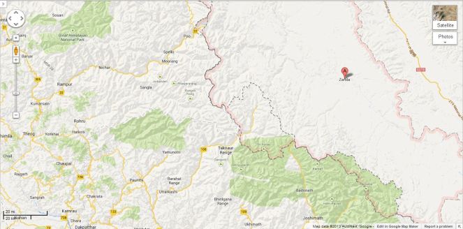
Tsada station on river Satluj (Shown as A in the Google Map)
This was read with first clause: “The two sides recognized that trans-border rivers and related natural resources and the environment are assets of immense value to the socio-economic development of all riparian countries.” Here “riparian countries” clearly includes lower riparian. But to suggest that this clause on its own or read with clause 5 mentioned above provides hope that China will include the concerns of the lower riparian in Chinese projects on shared rivers seems slightly stretched. The clause only recognises the asset value of rivers and related natural resources and environment for all basin countries and it is doubtful if it can be used to interpret that Chinese will or should take care of the concerns of lower riparian.
Thus the rather optimistic interpretation does not seem to emanate from the actual wording of the MoU, but the rather over optimistic interpretation by the Indian interlocutors, possibly including the Indian ambassador to China, who has been quoted on this aspect.
Real Achievement: GOI recognises value of Rivers! What is most interesting though is that Indian government has actually signed a Memorandum that recognises that “rivers and related natural resources and the environment are assets of immense value to the socio-economic development”. This is absolutely amazing and joyful development for rivers. Since there is nothing in the laws, policies, programs, projects and practices of Indian government that says that rivers are of any value. Now that Indian government has actually signed an MoU agreeing to such a value, there is sudden hope for rivers, it seems. Only lurking doubt, though is the word “trans-border” before rivers! We hope the Government of India applies this clause to all rivers, not just trans-border rivers, though we know from past that this hope is one a rather thin ice!!
SANDRP
Annexure:
1. Formation and Meetings of Expert Level Mechanism (ELM) on Trans-border Rivers
20-23 Nov, 2006
During the visit of the President of People’s Republic of China to India in November 20-23, 2006, it was agreed to set up an Expert-Level Mechanism to discuss interaction and cooperation on provision of flood season hydrological data, emergency management and other issues of trans-border rivers between the two countries. Accordingly, the two sides set up the Joint Expert Level Mechanism(ELM) on Trans-border Rivers. The Expert Group from Indian side is led by Joint Secretary level officers. Seven meetings of ELM have been held so far.
19-21 Sept, 2007
In the 1st meeting of ELM the issues related to bilateral cooperation for exchange of hydrological information were discussed.
10-12 April, 2008
In the 2nd meeting of ELM work regulations of the ELM were agreed upon and signed. It was agreed that the ELM shall meet once every year, alternatively in India and China.
21–25 April, 2009
The 3rd meeting was focused on helping in understanding of each other’s position for smooth transmission of flood season hydrological data.
26-29 April, 2010
In the 4th meeting the implementation plan on provision of hydrological information on Yaluzangbu/Brahmaputra River in flood season was signed.
19-22 April, 2011
In the 5th meeting the Implementation Plan in respect to the MoU on Sutlej was signed.
17-20 July, 2012
The 6th meeting of ELM was held at New Delhi where both the countries reached at several important understandings and a significant one of those understandings is – “The two sides recognized that trans-border rivers and related natural resources and the environment are assets of immense value to the socio-economic development of all riparian countries.”
14-18 May, 2013
In the 7th meeting held at Beijing, China where in the draft MoU and Implementation Plan on Brahmaputra river was finalized.
2. MoUs on Hydrological Data Sharing on River Brahmaputra / Yaluzangbu
2002
Government of India and China signed a MoU for provision of hydrological information on Yaluzangbu/Brahmaputra River in flood season by China to India. In accordance with the provisions contained in the MoU, the Chinese side provided hydrological information (Water Level, Discharge and Rainfall) in respect of three stations, namely, Nugesha, Yangcun and Nuxia located on river Yaluzangbu/Brahmaputra (see the map above) from 1st June to 15th October every year, which was utilized in the formulation of flood forecasts by the Central Water Commission. This MoU expired in 2007.
2008
On 5th June, India signed a new MoU with China on provision of hydrological information of the Brahmaputra /Yaluzangbu river in flood season by China to India with a validity of five years. This was done during the visit of the External Affairs Minister of India to Beijing from June 4-7. Under this China had provided the hydrological data of the three stations for the monsoon season from 2010 onward.
2013
During the visit of Chinese Premier Li Kegiang to India the MoU of 2008 has been extended till 5th June 2018.
3. MoUs on Hydrological Data Sharing on River Satluj / Langquin Zangbu
2005
A MoU was signed during the visit of the Chinese Premier to India in April for supply of hydrological information in respect of River Satluj (Langquin Zangbu) in flood season. Chinese side provided hydrological information in respect of their Tsada station on river Satluj (Langquin Zangbu in Chinese, see the map above).
Aug 2010
In order to supply flood season hydrological information on River Sutlej a new MoU was agreed in August 2010
Dec 2010
On 16 Dec 2010, during the visit of Prime Minister of China to India a new MoU was signed to provide hydrological information of Sutlej/Langquin Zangbo River in flood season by China to India with a validity of five years.
April 2011
During the 5th ELM meeting held in April, 2011 an MoU on Sutlej containing the Implementation Plan with technical details of provision of hydrological information, data transmission method and cost settlement etc. was signed in Beijing. The hydrological information during the flood season has been received in terms of the signed implementation plan.
Annexure compiled by Parag Jyoti Saikia
Post Script: Further reading: http://www.thethirdpole.net/2015/11/06/tibet-dams-hold-back-silt-not-water
Govt of India pushes unviable hydro projects in North East
Without due process
In a recently held meeting (see the latest updates on this issue from http://www.energylineindia.com/ on this below), the Committee of Secretaries have pushed for large hydro power projects in Arunachal Pradesh. As the agitation against the under construction 2000 MW Subansiri Lower HEP on Arunchal Pradesh border has shown any such move, without credible, independent and comprehensive options assessment, social and environmental impact assessment at project and basin level in a transparent and democratic way would prove to be disastrous not just from social and environment point of view, but also from economic aspects. Hurrying through such projects in the name of establishing prior use rights in the name of Chinese projects in Brahmaputra basin would not be helpful. The fact that the river and its ecology are in use by the people of Arunachal Pradesh, Assam, other North East and east India states, Bhutan and Bangladesh should be sufficient if prior use was indeed a tenable argument in international context.
Some new facts that have come to light from the CoS meet include:
According to the 9th report of the Inter-Ministerial Expert Group (IMEG), discussed during the course of the meeting, there has been an increase of three project sites on the mighty river since IMEG’s last report, prepared a few months earlier. A total of 39 Rune of the River projects/sites are now present on Brahmaputra and its tributaries.
Dam related peripheral infrastructural activity has gathered speed at Lengda, Zhongda and Langzhen, which are on the main course of Siang or Yarlung Tsangpo as it is called in Tibet. The Bome-Medog road which passes through the Great Bend Area is also being upgraded. The Joint Secretary, Ministry of External Affairs said that keeping in mind China’s bad track record to resolve water disputes, he was of the opinion that India should cooperate with other countries facing similar issues with China.
This report suggests that no instance of water diversion activities is discerned on the main course of the river and its tributaries.
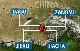
Jiacha could be the next hydroelectric project on the mainstream of Brahmaputra River. It may be followed by hydroelectric projects at Lengda, Zhongda, Langzhen, where dam related peripheral infrastructural activity (including 4 new bridges) has gathered speed.
Dagu and Jiexu projects, which are also on the main course of Brahmaputra River, along with Nangxian project may see considerable development activity in future.
The China is carrying out series of cascading ROR projects in the· middle reaches of Brahmaputra, the same may be replicated in the Great Bend Area as a viable alternative to a single mega project and this needs further monitoring.
The CoS has directed the Technical Expert Group (TEG) to submit its action plan for establishing India’s user right within a month’s time. Cabinet Secretary directed TEG to submit a blueprint for action with indicative time lines within a month. CoS has recommended Additional Secretary, Ministry of Power to chair the TEG. Notably, the TEG along with other standing groups like IMEG, will continue to submit their six monthly reports.
Unfortunately, none of the reports of the TEG or IMEG are in public domain, nor are they available under RTI Act. The people of north east are kept in complete darkness about the decisions these officials take.
About the projects in the NE India, the CoS meeting noted:
Special Secretary, Water Resources, stated that 92 HEPs (above 25 MW) with aggregate capacity of 36,272.5 MW have been allotted of which about 20 are at some progressive stage of development.
While for 11 HEPs, aggregate capacity of 8,510 MW, the detail project reports (DPRs) have been submitted to CEA for examination, 9 projects worth 10,570 MW have been concurred by CEA.
In the case of Pashighat (2700MW) project, Techno Economic Clearance has been received and public hearing is scheduled next month.
Indeed as SANDRP analysis of functioning of EAC shows, the Expert Approval Committee has said yes to the largest of projects from Arunachal Pradesh.
An important agenda of the CoS meeting was to assess the progress of the measures suggested by the committee in its 4th meeting held on April 26, 2011. The committee had directed a Joint Steering Committee consisting of representatives from NHPC and Assam government to end the long standing deadlock at the 2,000 MW Subansiri HEP. Notably, the Joint Steering Committee has submitted its report in July 2012. In response to the CoS decision that Ministry of External Affairs (MEA) should firm up views on the modalities of initiating a more informed public debate on the issue of the Brahmaputra water diversion, MEA and MoWR have formed a joint mechanism to pursue the same. An FAQ has also been prepared on the subject to disseminate awareness. Apart from this, MoWR has initiated action on the decision of the CoS to hold informal discussion between concerned ministries for constructing multipurpose projects in Arunachal Pradesh. An inter-ministerial informal discussion was held in October 2011. An outcome of the meeting was that discussion of rehabilitation, an issue hampering many projects, should be project specific. Further, the Planning Commission has formed an Expert Panel to take up the sub-basin wise Environmental Impact Assessment (EIA) study under the chair of Chairman CWC which will submit its report this month.
Many of these actions of CoS and other related bodies clearly lack credibility. The Central Water Commission itself largely acts like a lobby for big dams in India and it is never known to have taken any credible steps for environment or EIA. Under the circumstances, the sub basin wise study that is expected from CWC would not have any credibility.
South Asia Network on Dams, Rivers & People (www.sandrp.in)
In a significant move, India is pressing China to have either a water commission or an inter-governmental dialogue or an treaty to deal with water issues between the two countries.
This comes in the wake of Chinese move to approve construction of three more dams on Brahmaputra river in Tibet, in addition to the one being built without informing New Delhi.
Following the Chinese move, a high-level inter- ministerial committee, comprising officials from External Affairs Ministry, Defence Ministry, Department of Space among others met here to take stock of the situation and decided to take it up with China.
The issue was once again taken up when a senior Chinese embassy official met MEA officials to give details on the construction proposal.
“Though, the issue (of having a bilateral mechanism) has been part of our discussions earlier also, the recent move by Beijing has further pushed the matter. There is a need for some mechanism to deal with water issues between the two countries on the lines of what India has with other countries like Pakistan,” sources told PTI.
While India has an Indus Water Treaty with Pakistan under which the two countries share information and cooperate on the matter, a Ganges Treaty with Bangladesh establishes a 30-year water-sharing arrangement and recognises the neighbouring country’s rights as a lower-level riparian.
Recently, the Chinese cabinet had approved a document which mentions construction of three dams at Dagu, Jiacha and Jiexu on Brahmaputra.
Reacting to the Chinese move, the official spokesperson in MEA has said India carefully monitors all developments on the Brahmaputra river. “As a lower riparian state with considerable established user rights to the waters of the river, India has conveyed its views and concerns to the Chinese authorities, including at the highest levels.”
The official spokesperson also stressed the need for China to ensure that the interests of downstream states are not harmed by any activities in upstream areas.


![Three stations on Yarlung Zangbo - Nugesha, Yangcun and Nuxia (the green spots in the map represent these station)[iv]](https://sandrp.in/wp-content/uploads/2013/10/three-stations-on-on-yarlung-zangbo.jpg?w=663)