We would like to begin this long update on River Fish in India on Nov 21, World Fisheries 2018, on a positive note. What better way can there be then mention our own blog in this last year that portrays the fisherfolks as mascots of river conservation: https://sandrp.in/2017/12/15/riverine-fisherfolk-as-mascots-of-flowing-rivers-and-how-4-projects-treat-them-today/. Unfortunately, the struggle to get some place for the fisherfolks in the decision making continues. There are many positive developments here, though!
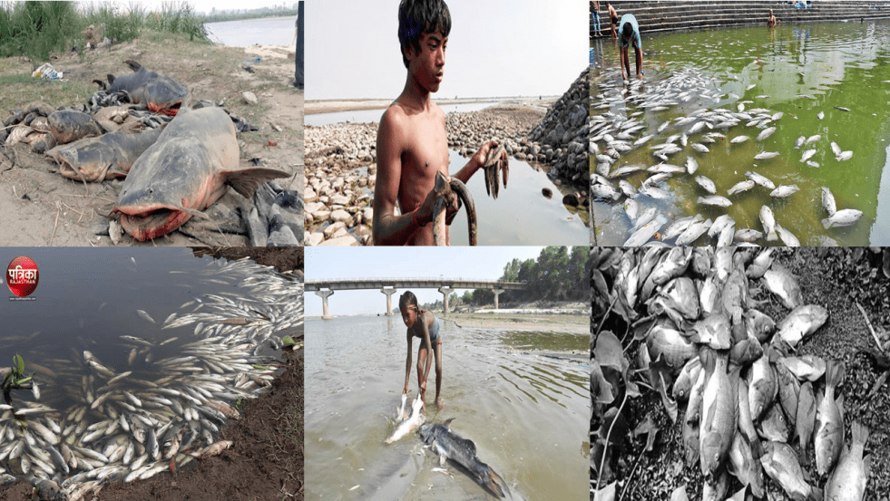
World Fisheries Day 2018: India’s Increasing Fish Kill Incidents
21 November is celebrated as world fisheries day across the world. Apart from crucial source of food and livelihood to lakhs of fisherfolks in India, fish diversity determines the health of the water body including lakes, ponds and rivers. However with growing threats and pollution mass fish mortality has been taking place in various rivers and lakes in the country every year. On World Fisheries Day 2018 SANDRP has put together known mass fish kill incidents that took place this past year to highlight the gravity of threat so that corrective measures can be taken by respective Governments and others concerned.
Continue reading “World Fisheries Day 2018: India’s Increasing Fish Kill Incidents”

DRP: 19 Nov 2018: India Rivers Week 2018 to focus on Ganga Rejuvenation
The India Rivers Week 2018, in fifth year, will be held at WWF, Delhi during Nov 24-26, 2018. The focus of the IRW this time is: “Can India Rejuvenate Ganga?“. Shri Rajiv Ranjan Mishra, Director General of the National Mission for Clean Ganga will address the inaugural session with Chief Guest Shri Jairam Ramesh, former Union Minister, in Chair. The meeting will see over 150 people from all over India participate to discuss state of India’s rivers at the only meeting in India focussing exclusively on rivers.
The Annual River Lecture will be given by Prof Rajiv Sinha of Indian Institute of Technology, Kanpur. The Bhagirath Prayas Samman award for the best work on River Conservation and the Anupam Mishra Medal for exemplary media work on River conservation will be given away by famous Chipco leader Shri Chandiprasad Bhatt.
Shri U P Singh, Secretary, Union Ministry of Water Resources has agreed to the chief guest at the concluding session on Nov 26, Monday. Started in 2014, the meeting is collectively organised by Yamuna Jiye Abhiyan, WWF-India, INTACH, Toxics Link, People’s Science Institute (Dehradun), Peace Institute and SANDRP.
For more information, please see: https://indiariversforum.org/2018/11/19/india-rivers-week-2018/. Follow IRW at: https://www.facebook.com/IndiaRiversWeek/ and https://twitter.com/IndiaRiversWeek
Continue reading “DRP: 19 Nov 2018: India Rivers Week 2018 to focus on Ganga Rejuvenation”
Namami Gange: Where is the intention?
There has been no lack of symbolism, funds, infrastructure, technology, promises, big statements and periodic announcements for Ganga by the Modi government. In fact, grand statements started even before the 2014 Parliamentary elections. But how do we gauge if there was an intention to rejuvenate the Ganga? May be if we could see a credible road map, a clear sense of purpose. If we could see signs of attempt to understand what the “development” plans are doing to the river. If we had a clear definition of what constitutes Ganga and what are the time bound goals of Nirmal and Aviral Ganga. Does the Namami Gange, the central program of Modi government on Ganga since May 2014 clear any of the tests? Even towards achieving Nirmal (clean) Ganga, if not Aviral (incessantly flowing) Ganga? Unfortunately, there is none.
As INDIA RIVERS WEEK 2018 gets underway in Delhi during Nov 24-26, 2018 with theme “Can India Rejuvenate Ganga“, let us try and see the state of Ganga and Namami Gange in the context of what is happening on this front in recent years. Continue reading “Namami Gange: Where is the intention?”

Dam Floods 2018: Assam, Himachal; Making Dam Operators Accountable
ASSAM: NEEPCO a repeat offender? On July 27, 2018 sudden release of water from NEEPCO’s Doyang Hydropower Electric Project (HEP), located in Wokha district, Nagaland led to flood disaster[1], submerging[2] about 36 villages in Golaghat a district in Upper Assam. According to Rony Rajkumar, project officer of the Golaghat district disaster management authority, around 5,575 people were affected by the deluge which damaged 887.9 ha of crop.
Earlier, on July 11, 2018, reviewing the severe flood situation Lakhimpur Assam, the Chief Minister (CM) Sarbananda Sonowal strongly warned[3] the state-owned power utility NEEPCO not to release water from its Ranganadi dam without warning like previous years.
Continue reading “Dam Floods 2018: Assam, Himachal; Making Dam Operators Accountable”
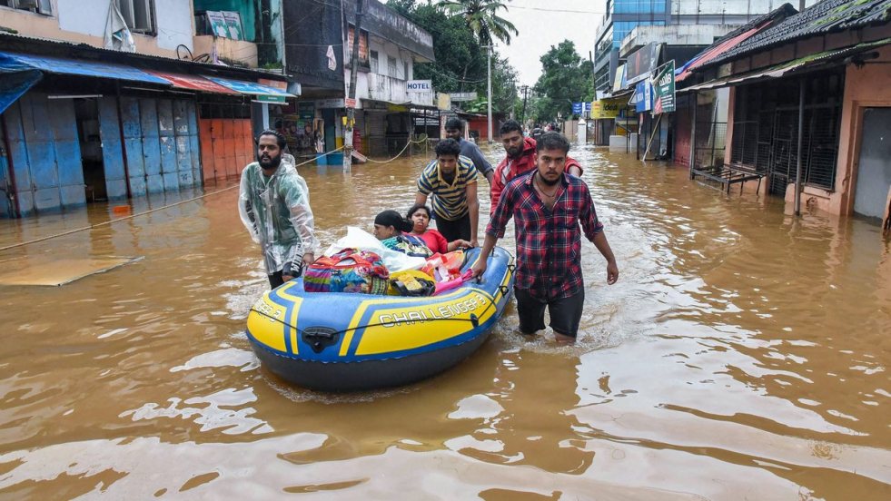
Kerala: Dams Floods 2018: Follow Rule Curves to Avoid Flood Disasters
Unprecedented Kerala deluge[1] that swept through the coastal state on the day of Independence day 2018 was most disastrous flood incident in the year. It has also been termed as one the worst flood in the state and reminded the people of July 1924 and July 1962 flood calamities. Many experts, several reports and studies have established the role of dams in worsening the deluge. According to reports, 35 out of the 46 dams within the state were opened for the first time in history[2]. All 5 overflow gates of the Idukki Dam were opened at the same time, for the first time in 26 years.
State Government Accepts Dams Role
Kerala is usually considered a flood-proofed[3] state with its undulating terrain. For a state that receives an annual average rainfall of nearly 3,000 mm, its natural landscape protects it from recurrent floods. Indeed, the Kerala flood has highlighted our poor dam management[4] system.
As per officials the crisis could have been contained[5] had the state “gradually released” water from at least 30 dams, in advance of high rainfall, adding that local authorities failed to foresee the imminent danger with high rain predictions. “Such floods have probably recurred after 100 years, exposing the State’s unprofessionally run reservoirs management system and unpreparedness on disaster mitigation and disaster resilience.
Continue reading “Kerala: Dams Floods 2018: Follow Rule Curves to Avoid Flood Disasters”
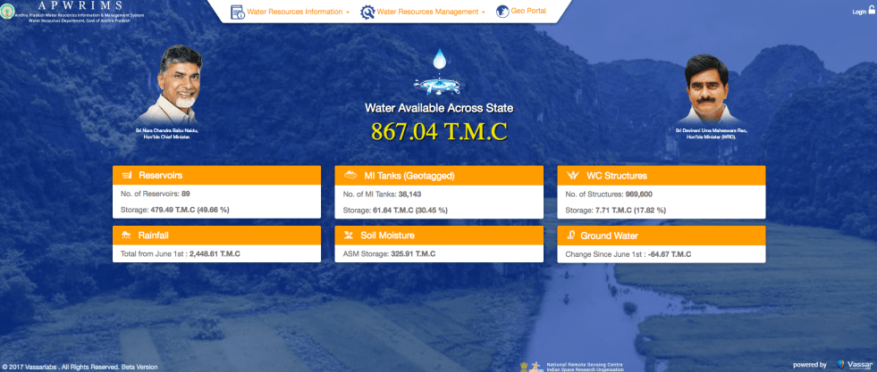
APWRIMS: Impressive Water Information System of Andhra Pradesh
Andhra Pradesh Water Resources Information and Management System[i] is truly impressive water information system, possibly not available in any other state or even at national level, at any time in India. The comprehensiveness of the water information system is striking, as it not only includes reservoir water storages of Major and Medium Projects, but also storages in minor projects, minor tanks, water conservation structures (check dams, percolation tanks) but also groundwater and most importantly, soil moisture. These are collected in real time from diverse information sources including on ground measurements, satellite based assessments and also sent via mobile apps from diverse sources. And the information is put out in real time, along with number of analysis. The data are collated and analysed using tools from Vassar Labs, like Machine learning, Artificial Intelligence and big data. Continue reading “APWRIMS: Impressive Water Information System of Andhra Pradesh”

DRP: 12 Nov 2018: Waterways Deteriorate Ganga, But Gadkari And Modi are Oblivious
PM Modi inaugurated the first multi-modal terminal on the Ganga river in Varanasi on Nov. 12 under a project aimed at promoting inland waterways as a cheaper and more environment-friendly means of transport. The multi-modal terminals are being built as part of the central government’s Jal Marg Vikas Project that aims to develop the stretch of the river Ganga between Varanasi and Haldia for navigation of large vessels weighing up to 1,500-2,000 tonnes. https://www.ndtv.com/india-news/pm-modi-to-inaugurate-1st-multi-modal-terminal-on-ganga-river-in-varanasi-1944924 (9 Nov. 2018)
Explaining the negative impact of waterways projects on Ganga River, Shripad Dharmadhikary in Hindi report titled जलमार्ग परियोजना बदहाल नदियों पर एक हमला writes that the projects lack public consultation “गंभीर बात है कि जलमार्ग विकास से सबसे ज्यादा प्रभावित होने की सम्भावना स्थानीय जनता को है। इसके बावजूद जलमार्ग के विकास से संबंधित ज्यादातर कामों के आयोजन और क्रियान्वयन के लिए न तो इनकी सलाह ली गई है, और न ही इनके बारे में जनता को जानकारी दी गई है। कुल मिलाकर इन जलमार्गों के सामाजिक और पर्यावरणीय प्रभावों का ठीक से आकलन नहीं हुआ है, ऊपर से इन्हें पर्यावरणीय मंजूरी के दायरे से बाहर रखा गया है और सारी प्रक्रिया में लोगों की सहभागिता का भी पूरा अभाव है। ऐसे में जलमार्गों के रूप में इतना बड़ा हस्तक्षेप हमारी नदियों पर एक और बड़ा हमला है जो पहले से बुरी हालत में हैं। https://www.downtoearth.org.in/hindistory/%E0%A4%A8%E0%A4%A6%E0%A5%80%E0%A4%B9%E0%A4%82%E0%A4%A4%E0%A4%BE-%E0%A4%AA%E0%A5%8D%E0%A4%B0%E0%A4%AF%E0%A4%BE%E0%A4%B8-62034 (5 Nov. 2018)
Continue reading “DRP: 12 Nov 2018: Waterways Deteriorate Ganga, But Gadkari And Modi are Oblivious”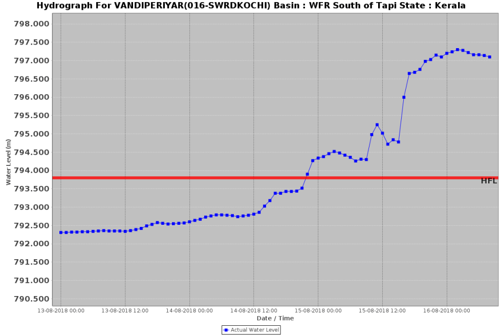
HFL crossing flood events during India SW Monsoon 2018
Even as the rainfall during South West Monsoon of India during June Sept 2018 was 9.4% below normal, a number of HFL (Highest Flood Level) crossing flood events were recorded on CWC’s (Central Water Commission) Flood Forecasting (FF) website[i]. Since CWC’s FF site does not provide archived information or comprehensive list of such events, we are here putting together a list of such events that we had noted during the SW monsoon, for future records and also understanding trends of high floods. Continue reading “HFL crossing flood events during India SW Monsoon 2018”
Ken River Yatra: Exploring A Threatened River And Knowing River People
Two environmentalists take a walk along a river and find that they should have brought along the policymakers, planners, engineers and politicians claiming to help it.
When heading out on an adventure, it is standard practice to look at satellite imagery of the area to chart an informed plan of action. However, when we were preparing for our walk along the Ken river, we couldn’t access a reliable map of the watercourse all the way from source to mouth.
We tried tracing the river on a map using satellite data for cues, moving upstream from an established point of identity: Chilla ghat, the confluence of the Ken with the Yamuna in Uttar Pradesh. However, this exercise proved difficult and led us astray multiple times, especially in the upper catchment area. It was only later, when walking along the river, did we realise that this was because almost all of Ken’s tributaries have a larger discharge than the Ken itself. Our virtual search for the Ken’s source kept taking us to the source of its tributaries in nearby hills. Thanks to the walk, we now have an actual and detailed map of the river that we intend to share soon.
Continue reading “Ken River Yatra: Exploring A Threatened River And Knowing River People”
