The National Green Tribunal, NGT marked its 4th Foundation Day on 18 October 2014, with an impressive fanfare. A full day function was organized at the Plenary hall of the capital’s iconic Vigyan Bhawan. NGT in this short span has acquired a formidable reputation as a unique, vibrant, active institute with independent & unbiased mind and forthright, quick redressal of petitions that come to it.
The function in two separate sessions, one in the forenoon and the other in the afternoon (a Seminar) was attended by large number of government officials, judicial officers, advocates, law school students, NGT petitioners and office bearers and members of the NGT Bar association.
NGT Foundation Function on Oct 18, 2014 (Source: FB page of Information and Broadcasting Ministry)
Invited dignitaries included Mr Justice Ranjan Gogoi (Judge, Supreme Court), Prakash Javadekar (Union Minister of State for Environment, Forests and Climate Change) and Ashok Lavasa (Secretary, MoEF&CC) in the forenoon session and Mr Justice Sudhanshu Jyoti Mukhopadhaya (Judge, Supreme Court) and Piyush Goyal (Union Minister of state for Power, Coal and new and renewable energy). Mr Justice Swatanter Kumar, the Chairperson of the NGT, Mr Justice Dr. P. Jyothimani, Judicial Member, Principal Bench, NGT, Prof. R. Nagendra, and Dr. D.K. Agarwal, Expert Members at the NGT also spoke and graced the dais.
The function included, in addition to the addresses by the invited dignitaries, the release of 2nd issue of NGT International Journal; the launch of new NGT Website (in the first session) and address by invitee experts (in the second session).
In the first session Mr Javadekar informed the gathering about his political beginnings from a water pollution struggle activist against factory pollution and Mr Lavasa categorically stated that the NGT is playing an extremely crucial role and that there is no move to dilute its powers in any manner. It was in the second session that very controversially one Mr M.K. Pandit was invited to speak as an invited expert.
The Minister of State for Environment, Forests and Climate Change (I/C), Shri Prakash Javadekar lighting the lamp at the 4th Foundation Day function of the National Green Tribunal, in New Delhi on October 18, 2014. The Secretary, Environment, Forests and Climate Change, Shri Ashok Lavasa and the Judge, Supreme Court of India, Mr. Justice Ranjan Gogoi are also seen (Source: FB page of I&B Ministry)
Mr Pandit began with highlighting how recent and how fragile the Himalayas were and that a 8+ richter scale earthquake in central Himalayas was round the corner that could flatten Dehradun. Very soon in his almost 25 minute speech changed track as if on a cue to how great the hydropower dam projects in the Himalayas were for the power security of the country. The Union Power Minister had by then just joined the function to nod in full agreement with all that the Mr Pandit was narrating. The audience on the other hand was left perplexed as to what was happening?
An invited speaker was eulogizing the great merits of high dams receiving approving glances from the power minister on an NGT seminar whose topic was “Natural Disasters, Environment & Role of NGT with special reference to Uttarakhand, J&K, Assam & Himachal Pradesh”. Clearly something was amiss, somewhere?
Secondly, Mr Pandit is not a neutral expert, but an interested party. As leader of scores of pro hydro Environmental Impact Assessments that he has led as part of the CISMHE[1] team (Center for Inter-disciplinary studies of Mountain and Hill Environment) has earned them millions as they also continue to mint more money. Typical of Indian EIAs, no EIA done by CISMHE has ever raised any difficult questions for the developers. It has also never concluded that any of the projects is unviable. CISMHE EIAs are as shoddy, incomplete and inadequate as any other[2]. For example on Luhri HEP, the CISMHE EIA was so problematic that even the Ministry of Environment, Forests and Climate Change’s Expert Appraisal Committee on River Valley Projects and the World Bank found it inadequate and unreliable.
Interestingly, CISMHE website says: “Ministry of Power, Government of India established CISMHE as an R&D Centre in power studies in environment in recognition of its excellent past performance”. This means that there is also conflict of interest here in CISMHE doing EIAs, since it has been set up as an R&D Centre by Ministry of Power, that is itself a promoter and developer of hydropower projects. No wonder, Mr Pandit said what the Power Minister wanted to hear and Power Minister made no efforts to hide his approval of what Mr Pandit was saying.
Very strangely, Mr Piyush Goyal claimed that Tehri dam was an example of good project in the Himalayas that saved Uttarakhand in the floods of June 2013. Mr Goyal should know that this claim had absolutely no basis and even an Expert Body appointed by the Supreme Court of India has shown, after listening to THDC, CWC and others that such a claim has no scientific foundation. Mr Pandit did try to support the unfounded contention of Mr Goyal, but the minister asked him to keep quite.
It became clearer, when a pointed question asked by Shri Manoj Misra of Yamuna Jiye Abhiyaan about what would have been the Tehri dam scenario if the Uttarakhand high rainfall event had occurred in the peak monsoon months of July, August or September and not on 16 June 2013 (as in fact happened in Sept 2010, when Tehri created a havoc in the downstream, damaging its own Koteshwar project[3]), when the dam was almost empty and only beginning to get filled, elicited an evasive response first by the Union Minister (we cannot have structures planned for every 365 days in a year). And later when Pandit ji tried to answer, he was asked to shut without him being able to even respond to the other two questions relating to how does he reconcile to the fact of a high intensity earthquake visiting a region where he had been advocating the dams; why was USA (as also some other countries), the mecca of large Dams bringing many of its dams down?
In any case, Mr Maharaj Pandit was contradicting himself, because he said something totally different in his article in The Hindu soon after the Uttarakhand disaster of June 2013: “Most downstream damage in otherwise flood-free areas is caused by dams and barrages, which release large volumes of water to safeguard engineering structures. Dam operators often release more water during rains than the carrying capacity of downstream areas, causing floods… Hydropower policy must consider building fewer dams and prioritise those that have the least environmental and social costs. Independent and serious monitoring of the catchment area treatment plans proposed by Forest Departments with funds from hydropower companies needs to be carried out and reported to the Green Tribunal.” In fact then in June 2013, he was on TV channels almost every night, talking about how Himalayas have the highest dam density in the world and that is such a big invitation to disaster! But he seems ready to change his stand to please the minister or the hydro project developers.
It seems as if Mr Pandit had been invited to justify the building of dams in the Himalayas in front of a large gathering of impressionable judicial officials and young student minds. It is possible that it was also intended to influence the minds of NGT members (judicial and experts) and other persons from judiciary in the face of a number of proposed dams being challenged before the various NGT benches and courts.
If a proper seminar was indeed planned on such an important matter, then there should have been several speakers on wide range of perspectives and topics and not just one speaker with conflict of interest and a clear agenda? The only other technical speaker, Dr R. Nagendran, an expert member with NGT southern bench spoke sensibly on how unscientific management of sanitary projects in hilly regions lead to parallel “Faeco-microbial disaster” which is difficult to tackle.
Mr Ritwick Dutta, secretary of NGT bar association said that the information about Mr Pandit speaking from NGT platform was not available in public domain and it is not clear how he was selected as a speaker.
Such blatant pro hydro bias in an NGT foundation day meeting is certainly unwarranted and out of place for an NGT function. An NGT platform should not have been allowed to be used for such biased presentation. We hope the bias apparent in this aberration is just that, an aberration and does not run deeper, considering that some hydropower professionals have been appointed on NGT benches.
We hope that at least in future the NGT, a statutory judicial body, otherwise doing a great job for the protection of environment, would be more careful in not letting its platform get used by the vested interests. The formidable reputation that NGT has acquired with a lot of remarkable orders should not be allowed to be affected by this one incident. NGT indeed needs to be strengthened in every way and not weakened in any manner.
It would also help if the NGT were to distance itself from this biased episode.
Pushp Jain, EIA Research and Response Centre (http://www.ercindia.org/, Pushp Jain pushp@ercindia.org) & SANDRP (based on interviews with those who were present at the NGT foundation day meeting)
Guest Blog by: Ritwick Dutta (ritwickdutta@gmail.com) Environmental Lawyer, Managing Trustee,
Legal Imitative for Forest and Environment, New Delhi
The review of Environmental Law is currently being undertaken by the High Level Committee (HLC) constituted by the Ministry of Environment, Forest and Climate Change. The task is huge and requires a much more detailed, comprehensive, real and effective consultative process than what is currently being done. The Committee is well within its right to say that such a task cannot be undertaken within such a limited and unrealistic time frame (2 months) and without the required expert composition.
The committee must give suggestions only on how to strengthen environmental law in India and not dilute environmental laws. Undermining environmental law is disastrous for the people, environment and even for economic development. It is pertinent to point out some events which have occurred in recent times which reflects on how the decisions on environment have had disastrous consequences both for the people and the economy.
Contrary to what is generally projected by the Industry Associations and a section of the press, environmental laws are not the cause of slow economic growth. Rather speedy and hasty approvals have been the cause of both environmental, social and economic loss and damage. It is imperative to focus on some facts which would be relevant.
The Ministry of Environment and Forest and its various expert committees never reject a project totally. Even if the approval is declined in one meeting it is presented in a subsequent meeting with minor modification. One can cite the recent case of Dibang Hydro Electric project in Arunachal Pradesh which was recommended for forest clearance despite being rejected twice by the Forest Advisory Committee.
An analysis of the approvals granted by the Regional Office of the MoEF based on recommendation of State Advisory group, the rate of approval is 78 Percent [See report of EIA Response Centre, study from January to April, 2014 at Annexure IIm, see the end of the blog]
The Expert Advisory Committee (EAC) constituted under the EIA Notification 2006 undertakes the task of appraisal at remarkable speed and hasty manner. It is worth quoting from the Judgments of Courts and Tribunals on the manner in which appraisal is done by the Expert Committees.
A. Samata Versus Union of India [National Green Tribunal , Appeal No 9 of 2011,] [Thermal Power Plant in Andhra Pradesh]
‘For a huge project as the one in the instant case, a thermal power plant with an estimated cost of Rs. 11,838 crore, covering a total area of 1675 acres of land, the consideration for approval has been done in such a cursory and arbitrary manner even without taking note of the implication and importance of environmental issues. On the same day the EAC took for appraisal not only the thermal power plant in question, but also other projects which would be indicative of the haste and speedy exercise of its function of appraisal of the project.
“As regards the functioning of the EAC, from the response of the MoEF to the RTI application referred to hereinbefore, it appears that the EAC granted as many as 410 mining approvals in the first six months of 2009. This is indeed a very large number of approvals in a fairly short time. We were informed that the EAC usually takes up the applications seeking environmental clearance in bulk and several projects are given clearance in one day. This comes across as an unsatisfactory state of affairs. The unseemly rush to grant environmental clearances for several mining projects in a single day should not be at the cost of environment itself. The spirit of the EAC has to be respected. We do not see how more than five applications for EIA clearance can be taken up for consideration at a single meeting of the EAC. This is another matter which deserves serious consideration at the hands of MoEF.”
C. Gauraxa Hitraxa Pauchav Trust Vs Union of India [Appeal No 47 of 2012 of NGT] [Pipava port, Gujarat]
“The relevant observations in the EAC meeting reveal that the presentation made by the Project Proponent was accepted as “gospel truth””
D. Sreeranganathan K.P and ors Vs Union of India : [Appeal No 172 -174 of 2013] [Aranmula Airport, Kerala]
“The Tribunal is able to notice a thorough failure on the part of the EAC in performing its duty of proper consideration and evaluation of the project by making a detailed scrutiny before approving the same……The EAC is constituted consisting of a Chairman and number of members who are experts from different fields only with the sole objective of national interest in order to ensure establishment of new projects or expansion of already existing activity without affecting the ecological and environmental conditions. Thus, a duty is cast upon the EAC or SEAC as the case may be to apply the cardinal and Principle of Sustainable Development and Principle of Precaution while screening, scoping and appraisal of the projects or activities. While so, it is evident in the instant case that the EAC has miserably failed in the performance of its duty not only as mandated by the EIA Notification, 2006, but has also disappointed the legal expectations from the same.
The above list is only illustrative and there are many other judgments reflecting the situation with respect to haste with which approvals are granted.
While undertaking any review the Committee must keep into account the following facts, issues and ground realities.
India’s Environmental law are a result of people’s struggle, international convention, commitments and judicial pronouncements and is aimed at ensuring sustainable development. Most provisions of the India’s environmental law have been an outcome of International Conventions pursuant to Article 253 of the Constitution eg, the Public Hearings and Environment Impact Assessment became part of India’s legal framework pursuant to the Rio Declaration of 1992 and the National Green Tribunal was set up pursuant to India’s committment to Principle 10 of the Rio Declaration.
‘Principle on Non-Regression’ has to be applied while undertaking review.
The principle of non-regression is understood as the requirement that norms which have already been adopted by states may not be revised in ways which would imply going backwards on the previous standard of protection.[2] This principle has been traditionally recognized in the area of human rights – that is, once a human right is recognised it cannot be restrained, destroyed or repealed. This theme is echoed in almost all the major international instruments on human rights, including the Universal Declaration of Human Rights. [3] Environmental rights are closely related to human rights as well, including cultural and social rights, and can be interpreted to apply in the context of environmental protection as well. In addition, the principle is increasingly being invoked in the context of environmental protection. The European Union has adopted this view through a resolution: [4]
97. Calls for the recognition of the principle of non-regression in the context of environmental protection as well as fundamental rights.
The Resolution of the UN General Assembly as the outcome document of the Rio+20 United Nations Conference on Sustainable Development reflects the acceptance of this principle as well:[5]
20. We acknowledge that since 1992 there have been areas of insufficient progress and setbacks in the integration of the three dimensions of sustainable development, aggravated by multiple financial, economic, food and energy crises, which have threatened the ability of all countries, in particular developing countries, to achieve sustainable development. In this regard, it is critical that we do not backtrack from our commitment to the outcome of the United Nations Conference on Environment and Development. We also recognize that one of the current major challenges for all countries, particularly for developing countries, is the impact from the multiple crises affecting the world today.
Therefore, the principle of non-regression applies as a human and fundamental right, as well as under the principles of environmental law – like “sustainable development” and precautionary principle”.
The concept of Sustainable Development has to be comprehensively understood and cannot be equated only with economic growth. The Rio Declaration of 1992 has to be comprehensively understood and read not in isolation but as a whole. Public hearings (Principle 10), EIA (Principle 17) Precautionary Principle (Principle 15), Compensation and liability regime (Principle 13) are the core of Sustainable Development and have been incorporated as part of national law. The aim should be to further include these in various laws in a comprehensive manner. Rule of law, the right to participate effectively in matters which concerns one’s life.
Expert Committees, Advisory Committees, Appellate Forums constituted of Bureaucrats do not inspire confidence. This Committee must recommend that any committee or appellate forums should not have any bureaucrats. The working of the National Environment Appellate Authority (NEAA) is a classic example of failure due to the fact that retired IAS and IFS officials were made vice chairman and member. The Delhi High Court in Vimal Bhai versus Union of India [CM No. 15895/2005 in W.P. (C) 17682/2005 has held:
“The list produced by the petitioners of appeals before the NEAA shows that most of the appeals disposed of thus far have in fact been dismissed, comprised as it is of retired bureaucrats, minus the Chairperson and Vice Chairperson. The NEAA is, therefore, at present neither an effective nor an independent mechanism for redressing the grievances of the public in relation to the environment clearances granted both either the State or the Central Government.”
Conclusion:
There is clearly a need to review environmental laws. Yet neither the objective and purpose is clear of the present exercise. The Environment (Protection) Act, 1986 has numerous notifications issued under it. It ranges from EIA Notification to rules regulating the use of Plastics and microorganisms. Will the present review cover all these? These are issues which needs clarity. In addition, the Committee has to genuinely interact with all concerned persons across the country. The present process cannot be called consultative at all.
India’s environment has already impacted negatively due to hasty decisions as evident from numerous decisions of the Courts, the least this HLC can do is not to prepare a hasty report based on limited one sided information and limited public interaction.
[Earlier Blog on HLC: https://sandrp.wordpress.com/2014/09/26/review-of-environment-laws-is-necessary-but-the-tsr-subramanian-hlc-lacks-credibility/]
Ritwick adds in post script: So far as ELMA is concerned, it is not even in a form that can be called as a Bill. The ELMA has many dangerous provisions and the sole aim is to manage the progressive provisions in all the other laws. ELMA gives overriding powers to the environmental authority to pass any direction. The thrust of ELMA is to ensure that those who approach the courts for redressal of their grievances face the threat of penalty. I feel that one of the most problematic provisions of ELMA is the fact that it combines all clearances (CRZ, EC and FC) into one (Single window) with very limited scope for appeal. The Appeal will have to be filed within 30 days of approval and before a Board constituting of two serving or retired secretaries to the Government! The process without doubt was a hurried one.
State Advisory Groups (SAGs): Recommendations for Forest Clearance during January-April 2014
The Forest (Conservation) Rules, 2003 under the Forest (Conservation) Act 1980, provide that proposal involving forest land of more than forty hectare shall be sent by the State Government to the Secretary to the Government of India, Ministry of Environment and Forests (MoEF) while proposals involving forest land up to forty hectare shall be sent to the Chief Conservator of Forests or Conservator of Forests of the concerned Regional Office (RO) of the MoEF.
RO is empowered to scrutinize and sanction the proposals involving diversion of forest area up to 5 hectare. In respect of proposals involving diversion of forest area above 5 hectare and up to 40 hectare and all proposals for regularization of encroachments and mining up to 40 hectare, the proposals are examined by the RO in consultation with State Advisory Group consisting the representatives of the State Government from the Revenue Department, Forest Department, Planning and /or Finance Department and concerned Department (User Agency).
State Advisory Groups (SAGs) are constituted by the Ministry of Environment & Forests, Government of India, under the Forest (Conservation) Act, 1980 for each State and Union Territory.
The view of the Advisory Group are recorded by the Head of the RO and along with the same, the proposals are sent to Ministry of Environment & Forests, Government of India, New Delhi for consideration and final decisions.
The meeting of the State Advisory Group (SAG) is normally held once in a month at concerned State Capital as per a pre-decided schedule for each State and Union Territory.
Agenda and minutes of SAG meetings are uploaded on the MoEF website.
In this report, we have analysed minutes of SAG meetings all over the country from January to April 2014. During the period, minutes of meetings in 10 states are available in public domain.
As per the information available on MoEF website, there were 16 meetings during this period of four months in which 541 ha area has been recommended for diversion. These meeting happened in Gujarat, Maharashtra, Madhya Pradesh, Uttarakhand, Andhra Pradesh, Karnataka, Kerala, Punjab, Tamil Nadu and Odisha. Gujarat leads with maximum diversion of 138 ha followed by Maharashtra with about 100 ha diversion.
It is interesting to note that Transmission Line is at top of the table taking maximum recommendation for diversion, 142 ha (26 %) closely followed by Roads with 138 ha (25 %). If we include Railways which takes 56 ha (11%), it is conspicuous that ‘linear intrusion projects’ are taking 62 per cent of the total recommended diversion.
The total number of projects considered by SAGs during the period was 41 of which 32 were recommended, i.e.78 per cent. It is alarming to note that not even one project was declined by SAG!
Every possible violation of norms, procedures, law and democratic governance is being committed in pushing clearances for the India’s largest capacity hydropower project, which involves India’s highest dam proposed so far & North East India’s Largest capacity reservoir: the 3000 MW Dibang Multi Purpose Project in Arunachal Pradesh. The players involved in these violations include the Union government of NDA led by BJP (UPA earlier), including its cabinet and Union Ministry of Environment, Forests and Climate Change (MEFCC), Ministry of Power, State government, the project developer company NHPC Ltd, the Expert Appraisal Committee (EAC) and Forest Advisory Committee (FAC).
The project will need more than 4700 hectares of biodiversity rich Forest area with several Schedule I species in Arunachal Pradesh. It will also have significant downstream impacts on the people & environment of Arunachal and Assam and Dibru Saikhowa National Park. Most of its impacts have not been either properly assessed or considered by the developer, EIA agency or the EAC & MEFCC.
Déjà vu: We did the same for Lower Subansiri HEP! It seems the government is indulging in the same blunders that the previous NDA government[1] indulged in over a decade ago while clearing the then-largest capacity hydropower project: the 2000 MW Lower Subansiri Hydropower Project (LSHP), also in Arunachal Pradesh. Environment clearance for LSHP came on July 16, 2003 and stage I forest clearance came on June 10, 2003. Exactly the same set of players were involved in manipulating LSHP clearances over a decade ago. The developer is also the same: NHPC. The government at centre is again led by NDA.
Aaranyak environmental group of Assam, in a letter dated May 16, 2002 to the then-Chief Justice of India had highlighted the violations involved at various stages in the decision making of LSHP including during public hearings, in conducting EIA, in giving environment, forests and wildlife clearances. Almost all the issues that Aranayak letter raised then are applicable in case of Dibang with even greater force. But it seems in the twelve years since 2002 when that letter was written, our environmental governance has only degenerated.
The fate of the LSHP is a lesson in itself. After spending over Rs 5000 crores (Rs 50 Billion), the work on the project came to a standstill in December 2011. It has remained stalled for 34 months since then, following India’s biggest Anti dam People’s movement so far. This is unprecedented in India’s hydropower history. NHPC Ltd has been trying every possible trick to resume the construction work on LSHP, without genuinely trying to address the issues people’s movement has been raising.
Dr Mite Linggi, Representative of Kere A Initiative for Cultural and Ecological Security said exactly that at the public hearing of Dibang Project on March 13, 2013: “It is evident that the 2000 MW Lower Subansiri Project is stalled since Dec 2011 because the technical, environmental and social concerns of the people of Assam were not considered earlier… Ignoring downstream concerns will only ensure that this project to will meet the same fate as Subansiri Lower Project (2000 MW and get stalled by people of Assam.”
It seems none of the players have learnt any lessons from the blunders committed in LSHP’s decision making. If this is how Dibang Project is being pushed down the throat of the people of Dibang Valley, Arunachal Pradesh and the North East India, they will have no option but to oppose the project and the Dibang Project may have the same fate as that of LSHP. Those who have been involved in the decision making now will then be held accountable for the wrong decisions and manipulations.
Dam site and the Dibang River Basin (Source – EMP)
THE DIBANG PROJECT
The foundation stone of 3000 MW Dibang Multipurpose Project on Dibang River was laid on 31st January 2008, by Prime Minister Manmohan Singh[2] when the project had no clearances, showing utter disregard the former PM had for statutory clearances or environment or affected people. The project affects Lower Dibang Valley and Dibang Valley districts of Arunachal Pradesh, and significantly, several districts in downstream Assam.
Considering the fact that Dibang has the largest installed capacity for a project in India, involving highest dam in India and biggest reservoir in North East India so far, one expected the EAC to be much more diligent while considering the project and even more so considering the experience of the LSHP. But that, it seems, was expecting too much.
The first thing that would strike any one who goes through the EAC and FAC documents is that the basic parameters of the project are yet unclear even as the EAC and FAC have recommended clearances, within the span of a week, under pressure from their political masters. Unbelievably, these two committees functioning under the same Ministry have recommended clearance for differing capacities, differing heights, differing submergence areas and so on!
This is because the NHPC knowingly misled the EAC in its meetings by presenting the 288 m height (above the deepest foundation level) dam with 545 m elevation at Full Reservoir Level (FRL) and 3.75 Billion Cubic Meters (BCM) of storage capacity at FRL. The same NHPC, in FAC meeting on Sept 22, 2014 provided sensitive analysis with dam height reduced upto 40 m, but this was not even mentioned before the EAC!
Let us review the how the EAC and FAC dealt with the project.
A. ENVIRONMENTAL CLEARNACE FOR THE DIBANG PROJECT:
The Expert Appraisal Committee (EAC) of the MoEF, which holds the distinction of having a zero rejection rate for the projects it appraises, recommended Environment Clearance to 3000 MW Dibang Multipurpose Project in its 77th meeting on 16th Sept, 2014.
The Project was given TOR (Terms of Refence) clearance on 17.8.2009. Public hearings in Lower Dibang and Dibang Valley districts were held on 11.3.2013 and 13.3.2013 respectively, with huge protests from affected people. The EAC earlier considered the project in 68th meeting in Sept 2013, in 73rd meeting in March 2014, in 74th meeting in May 2014 and now in 77th meeting in Sept 2014.
Some key questions that arise as to how the EAC arrived at the positive recommendation:
1. Was there any Public Hearing in downstream Assam? Was there proper public hearing in Aruunachal Pradesh?
Although Dibang Multipurpose project will have impacts in the downstream Assam, as accepted by NHPC Ltd, WAPCOS and recorded in EAC minutes, no public hearing has been conducted in Assam, in complete violation of the EIA notification which clearly states that in all affected districts public hearings must be held. The submissions from Assam were not discussed during EAC minutes. The people of Assam have been completely ignored in the decision-making about a project that will affect them. Several people who spoke at the Dibang Public Hearing in Arunachal Pradesh in March 2013 raised this issue, but MEFCC and EAC failed to do anything about this even after SANDRP submissions to EAC also raised this issue.
Even in Arunachal, the public hearing process has seen several violations, leading people to oppose the project and the public hearings, see the quotes from the public hearings given below. Consequently, the public hearings were disrupted by the local people and had to be cancelled several times. The MEFCC, unfortunately, has no concern for the quality of the whole consultation process and sees it as only a box to be tick marked. The EAC does not even look at issues related to public hearings.
View of One of the affected villages show the rich forest that the project will destroy (Source – EIA)
2. Were the issues raised at public hearing in March 2013 addressed?
No. As is clear from the report of the public hearing for the project held at Roing and New Anaya on March 11 and 13, 2014 respectively, the affected people raised a lot of critical issues about the project, EIA, EMP and Public hearing.
In the Minutes of the 68th meeting of EAC held in Sept 2013 and the 73rd EAC meeting held in March 2014, there is one paragraph (same para in both minutes) on public hearings: “Concerns Raised During Public Hearings It was explained that in general, the people were satisfied with the EIA and EMP reports and proposed R&R plan and community and social development plan. R&R plan has been formulated in line with the State R&R Policy, 2008. They took keen interest in knowing the R&R package and community and social development (CSD) plan. However, during public consultation prior to public hearing and during public hearings of Dibang Multipurpose Project, in addition to community and social development plan more infrastructural development in both Lower Dibang Valley and Dibang Valley Districts were sought viz., up gradation of District Hospitals in both districts, financial assistance for schools, colleges and polytechnic, and construction of cultural museum at Roing and ITI at Anini etc. Besides this for downstream people, the main concern was protection of downstream area in case of dam break / high flood. Keeping this in view, a lump sum provision of Rs. 17100 lakhs has been proposed for consideration of MoEF for mitigative measures at downstream and other infrastructural facilities as raised during public hearings in addition to R&R and CSD plan.”
The claim that “in general, the people were satisfied with the EIA and EMP reports and proposed R&R plan and community and social development plan” is a complete lie, as we see from the quotes from the official public hearing minutes below.
It seems the EAC members have not bothered to read the public hearing report, and they have willingly or unwillingly been misled by the NHPC and EIA agencies. To illustrate the critical issues raised at the public hearings, we are giving below some quotes from the official public hearing report. Most of these reports remain unaddressed in the EIA-EMP submitted to the MEFCC, but MEFCC and EAC has not bothered to check this.
Shri Lokha Elapra, President, All Idu Mshmi Students Union: “Poor planning of mitigation from impacts during construction phase. Mitigation measures fail to address issues of demographic impacts, socio-cultural concerns and preservation of traditional land and livelihood… EMP does not have any provision to address this. EIA and EMP does not have any mitigation measures to preserve nor compeansation for permanent loss of mithun grazing areas, fishing grounds and medicinal plants thus endangering the loss of Mishmi Takin (rare Animal), Mishmi Monal (rare Bird) and Mishmi Teeta (rare medicinal plant)… Flood control of Eze (Deopani River to protect Roing Township… A cumulative impact study in the Dibang river basin must be undertaken.”
Shri Raju Mimi, Member, Mishmi Scholar’s Association: “NHPC had undermined the seismic design parameters as recommended by the experts of IIT Guwahati, Guwahati University and Dibrugarh University in respect of the Subansiri Dam. In this regard can the community members of the affected areas be certain that such careless disregard for dam safety be not repeated by NHPC in this case? All the documents related to dam design and safety be made public. Also, the documents should be peer reviewed by independent group of scientists. Ecological concerns like extraction of boulders from ecologically sensitive Important Bird Area (IBA). No impact assessment made regarding this in the EIA report… Hence a cumulative impact study in the Dibang river basin must be commissioned. Socio-economic concerns like the catchment area treatment (CAT) plan will restrict land use resulting in loss of land and livelihood. NHPC must ascertain such losses and compensate the people affected by CAT… There is possibility of loss of land by destabilization of soil due to the huge reservoir. What mechanisms will be implemented to address these losses? ”
Shri Kelo Pulu, President IMCLS: “Environment Monitoring Cell to assess and review the various mitigation measures as mentioned in the EMP is not convincing. Therefore, the Government of Arunachal Pradesh should immediately notify the formation of an independent Committee consisting of less than 5 members of local Idu Mishmi people.”
Shri Moba Riba: “Conduct Public hearing at Dambuk Sub division.”
Shri Jibi Pulu: “Additional EIA-EMP must be undertaken to ensure the minimum impacts to the ecology of Dibang area. The Community people will lose an area of 10390 ha that will be required for CAT plan. This area being grazing area of Mithun will be lost. The EIA does not have any data or estimate/ valuation of this resource. Without any compensation the livelihood rights cannot be taken away from the community. EIA studies about wildlife conservation is inadequate. EIA studies carried out regarding assessment of economic and medicinal plants is not project specific nor community focused. It does not have any reference, assessment and compensation of economically valuable plants like Piper mellusa and Paris polyphylla. The impact of 1950 earthquake of 8.7 magnitude.. Is the dam axis and reservoir standing along the seismic fault line? The impoundment of the drainage system by building dam will have major effect.. Hence, EIA studies on downstream impact particularly study of Deopani drainage and its siltation status is absolutely necessary.”
Dr Mite Linggi: “As recommended by the Planning Commission Committee we demand for a Dam safety design panel for an independent assessment of safety of Dibang Dam. There are lacunae in EIA-EMP reports. This must be rectified.”
Shri MartinLego: “Resistance capacity of the mountains which fall in the reservoir is not studied. Dam should be able to withstand flashflood. Construction of flood protection works with RCC wall supported by vegetative cover on both banks of Dibang River… Our demands must be fulfilled then only we will support.”
Shri Mibom Pertin, President Adi Bane Kebang (ABK):“Till date no initiative has been taken by the State Government, the district administration or the NHPC to educate the people… the EIA EMP must be modified/ rectified wherein safety measures and actions to be taken in case of dam break… Until and unless the above points are fulfilled the holding of this public hearing is strongly opposed by ABK.”
Shri Jowar Moyang: “Demand to establish a family dossier of the entire downstream people… Downstream not reflected in the EIA/EMP and DRP therefore, a separate guideline be made to include the downstream within the defined local area. The demands placed above must be addressed to within three months of this hearing or else will protest against the construction of the project.”
Shri Nun Pertin, President, Dibang Adi Students’ Union (DASU): “Downstream people are unaware of the project benefits, impacts and other issues which are mandatory to be known before the commencement of the project. Therefore, public hearing in this regard must be conducted within blocks and subdivision of Lower Dibang Valley. This must be furnished in written assurance form within one week’s time. ”
Shri Anjite Menjo, Zilla Parishad Member, Iduli Anchal Block and Shri Chiliko Meto, ZillaParishad Chairperson: “Environment Monitoring Cell to assess and review the various mitigation measures as mentioned in the EMP is not convincing. Therefore, the Government of Arunachal Pradesh should immediately notify the formation of an independent Committee consisting of less than 5 members of local Idu Mishmi people… Hence a cumulative impact study in the Dibang river basin must be commissioned.”
Dr Mite Linggi, Representative of Kere A Initiative for Cultural and Ecological Security (KICES): “It is evident that the 2000 MW Lower Subansiri Project is stalled since Dec 2011 because the technical, environmental and social concerns of the people of Assam were not considered earlier. Report of the Planning Commission appointed Committee of Dr C D Thatte and M S Reddy has raised several serious concerns about the downstream impacts of the 2000 MW Subansiri Lower Project. Therefore, keeping this in mind, it is absolutely important that public consultation in Assam is carried out before the Dibang project gets environment clearance. Public consultation in Assam is not only necessary to address the concern of the people, but it is a pre-requisite for the people of Dibang Valley in the upstream… Ignoring downstream concerns will only ensure that this project to will meet the same fate as Subansiri Lower Project (2000 MW and get stalled by people of Assam. Rights of the people to use Catchment Area will be denied. Will compensation be included for them? Is it possible for NHPC Ltd to formulate new criteria for all those villages perched atop to include within affected families?”
Shri Lokha Elapra, President, All Idu Mishmi Students’ Union (AIMSU): Raises most of the critical issues raised above including need for Cumulative Impact Asessment, inadequate EIA-EMP, Impacts of demographic changes, lack of assessment of loss of grazing land, fishing right. “We do not want to be refugees in our land.. We the Idu Mishmi have a way of living where we live independently. Past history is proof of it. We had never been ruled and can never be ruled under any circumstance or vice versa. The plot which the NHPC Ltd claim giving free of cost is by virtue forcefully asking us to live in that piece of land where the PAFs are not satisfied.”
Shri Athupi Melo, Ex-ZPM, Anelih-Arju Block and Representing New Endoli village: “Public hearing on Dibang Multipurpose Project (3000 MW) was postponed 10-14 times earlier as the consent of the public was not taken before preparing EIA and EMP reports. The NHPC Ltd had cheated the entire affected people by concealing information and letting the awareness remain within the high reach people only. The NHPC Ltd as per their survey has shown 5 villages, 72 families, 243 persons, 938.8 ha of agriculture land as to be affected by the project. Do they know that the storage reservoir will submerge the land mass which belongs to another 34 villages of the valley?”
Shri Kupu Miku-ASM Arzoo and Representative of Apako village: “Had been resisting NHPC Ltd for the last ten years. Nothing was made known as to how much land would go and how much compensation would be provided.”
Shri Rezina Mihu, General Secretary, All Idu Mishmi Students Union (AIMSU): “It has been six yeas of resistance till this morning. The former President of AIMSU sacrificed his life fighting against the Dibang Project… the EIA-EMP is still not upto the mark.”
This selection of quotes from the Public hearing and reading of NHPC response, EIA-EMP and EAC minutes show that not only NHPC has failed to satisfactorily respond to most of these issues, the EAC and MEFCC has not even bothered to check the veracity of the claims of NHPC and uncritically accepted the NHPC claims. Inadequate response to the issues raised at the public hearing means that environmental clearance given to the project is legally untenable.
Anxious afffected people outside the public hearing Hall in March 2013 (Source – PH Report)
3. Has there been proper Environmental Impact Assessment of the project? Kalpavriksh, SANDRP, affected groups from Assam and Arunachal have made several independent submissions to EAC on the inadequacies of the EIA (Environmental Impact Assessment). SANDRP itself sent four different submissions (dated Sept 20, 2013, April 2014, May 2014 and Sept 12, 2014) highlighting various inadequacies of the EIA including:
Lack of compliance with the Terms of Reference of the EIA
Lack of basin wide cumulative impact assessment
Impact of mining of materials for the project not assessed
Lack of downstream impact assessment (more details below)
Lack of assessment of how climate change will affect the project and how the project will worsen the climate change impacts.
Lack of options assessment
Severe Impacts of Migration of Outsider on Local Tribal Community not assessed
Impact of the project on disaster potential in the project area as well in the downstream including Assam not assessed
Impact of changing silt flows downstream not assessed
As noted above, large number of speakers at the public hearing also pointed out the inadequacies of the EIA-EMP.
4. Are downstream impacts on Assam & Arunachal Pradesh Studied?
No credible study of the impact of the dam, dam break and peaking on Assam and Arunachal Pradesh in the downstream has been done.
Several speakers at the public hearing raised this issue of inadequate downstream impact assessment, as can be seen from the quotes from the public hearing listed above.
It may be mentioned here that the biggest issue plaguing the LSHP is lack of downstream impact assessment, and the EAC, MEFCC, NHPC or the EIA agencies (WAPCOS, which by now is notorious for doing substandard studies and National Productivity Council). Even Assam and Arunachal Pradesh state governments also seem least bothered. Also, it seems no lessons have been learnt after Larji mishap when 25 students were washed away due to demand-driven water releases by upstream hydropower project.
5. Has the impact of Peaking on Downstream Assam & Arunachal Pradesh studied?
NO
This is despite the fact that submissions were sent to the EAC from several organizations and individual also from Assam, drawing their attention to impact of peaking in downstream Assam, especially in lean season (winter) when flow fluctuations will range from 111 cumecs (Cubic meters per second) to about 13 time rise in volume at 1441 cumecs in a single day. Fluctuations can happen twice or thrice in a single day.
6. Has the impact on Dibru Saikhowa National Park in the downstream Assam studied?
NO
The EAC has shown zero application of mid in this respect. There are several hydropower projects being constructed on the three main tributaries of Brahmaputra upstream of Dibru Saikhowa National Park in Assam. All these hydropower projects will undertake peaking operations. EAC has considered these projects separately, as a part of basin studies and as a part of downstream impact studies on Dibru Saikhowa National Park.
In all these studies, the level fluctuation at the National Park when the three major projects in the upstream undertake peaking operations is different, as per the convenience of the project proponent! EAC has considered all these studies without raising any questions about this convenient difference in figures even when the contradictions were brought to EAC’s attention by SANDRP.
The EAC has recommended Clearance to Dibang Multipurpose Project accepting the contention of the NHPC that “water level fluctuation in Dibru Saikhowa National Park (DSNP) will be less than one meter.”
However, the same EAC has considered EIA of Lower Siang HEP (by WAPCOS) where the fluctuation at Dibru Saikhowa when all projects are peaking is said to be 8 feet (2.38 meters)
The Report on “Effect of Peaking power generation by Siang Lower HEP, Demwe Lower HEP and Dibang Multipurpose HEP on Dibru Saikhowa National Park” also by WAPCOS states that level difference when all three projects are peaking is estimated to be 34 mts i.e. 7.67 feet. (Page 26)
EAC did not question these glaring differences in these models even when a submission highlighting these points was sent to the EAC on 13.09.14, before the 77th EAC meeting. The submission is not mentioned in the minutes, neither discussed, also violating Hon. Delhi High Court Orders (Utkarsh Mandal Case).
7. EAC decision violates its mandate; MEFCC & NHPC guilty of misleading EAC.
During the entire appraisal process, the EAC has failed to pose any difficult questions to NHPC, has not taken a stand supporting Assam, has not even initiated discussion in that direction, has turned blind eye towards submissions it received raising critical concerns, has overlooked contradictions, has overlooked precautionary principle and welfare of people in the downstream Assam and has refused to learn any lessons from the LSHP experience or the Larji Mishap.
While discussion about height reduction of Dibang upto 40 meters were initiated in MEFCC/ NHPC since Feb 2014, the MEFCC or the NHPC has not brought this proposal to the attention of the EAC and the EAC has taken absolutely no notice of this and has not even asked for this 40 m height reduction. The only reference we can find to the height reduction proposal is in the minutes of the 73rd EAC meeting, where too there is reference to only 10 m ht reduction. And yet, there is no mention of this in the minutes of the 77th EAC meeting where the EAC recommended clearance to the project.
This alone is sufficient to make the EAC decision legally untenable and make both MEFCC and NHPC guilty of not informing the EAC about these developments more than six months after they were initiated.
The EAC on its part has not shown the will to ask for a realignment of the project to minimize its downstream impacts, peaking impacts and submergence impacts. Such biased conduct and the decisions of the EAC, sidelining genuine concerns are in complete violation of the mandate given to EAC and extremely damaging to environmental governance of the country and are a reason for increasing conflicts, delays, protests and strife underlining its callousness towards environmental impacts and local resistance.
The issues that FAC raised while rejecting the Forest clearance are the very issues that EAC should be concerned about since they are under their mandate. But not only EAC did not raise them on their own, but even after they were brought to the EAC’s attention by SANDRP, the EAC failed to even discuss those issues.
8. Issues on Dibang raised in earlier EAC meeting remains unanswered
The decision making paragraph of the minutes of the EAC meeting of Sept 16-17, 2014 on Dibang Project reads: “After critically examining the proposal and considering the response to various issues raised in the earlier EAC meetings, the project was recommended by EAC for accord of Environmental Clearance to Dibang Multipurpose Project. However, EAC suggested that 20 cumec flow may be released towards e-flow in the 1.2 km diverted stretch as 15 cumec gives just sufficient quantity. EAC noted that beyond this 1.2 km, adequate flow will be available from TRT which will be minimum in the order of 85 cumec at 80% rated discharge of one turbine.”
It is clear that this paragraph does not reflect any application of mind by EAC if the response provided by NHPC to the various issues raised by EAC and others’ submissions to EAC are adequate. Even in this paragraph, it is not clear what is the basis of EAC decision to recommend 20 cumecs flow downstream of the dam and not the norm that EAC is following for other projects (30% in monsoon, 20% in lean season and 20-25% in non monsoon non lean season). Nor is it clear what is the basis and impact of operation of one of the (there are 12 turbines, each of 250 MW installed capacity in this project) turbine at minimum 80% capacity round the clock. This non application of mind on the part of the EAC is the norm of EAC and not an isolated incident.
In fact, reading through the minutes of all the EAC meetings since Sept 2013 where Dibang EC (Environment Clearance) was discussed, it is clear that while EAC has raised a large no of questions and reported some of the information submitted by NHPC, no where can we find application of mind of the EAC where it is stated that the information/ responses provided by NHPC is adequate or not. The uncritical acceptance by the EAC about the information/ responses provided by the developer is another noteworthy feature of EAC decision.
Let us illustrate this. The minutes of the 73rd EAC meeting held in March 2014 says: “A detailed fisheries (also flora and fauna) survey was conducted by Centre for Inter-Disciplinary Studies for Mountain and Hill Environment (CISMHE), Delhi University in the month of December 2013.” Immediate question than arises is, why were the fisheries and other surveys done only in one month and not across the year as is the normal practice? What were the outcomes of the study? You will find neither critical questions, nor any answers in the EAC proceedings.
Here is another example. The minutes of the 74th EAC meeting held in May 2014 says: “It was informed that fluctuation in the water level at upstream of Dibang-Lohit confluence due to peaking operation will be about 17 cm which is almost negligible considering the size of the river.” Shockingly, the EAC does not even ask: A. If this estimate is sound and if it is consistent with conclusions of other studies; B. What will be the level fluctuation at different points along 60 km stretch of the river upstream from this point to the project site and what will be the impact there of. EAC’s such uncritical acceptance of apparently contradictory and inadequate responses from the developer is the norm and not an isolated incident. Considering that EAC was considering the largest installed capacity project of India, highest dam of India and biggest reservoir in North East India so far, one expected the EAC to be more diligent. This was even more so considering the experience of the LSHP.
To further illustrate, the minutes of the 74th EAC held in May 2014 says: “The point-wise reply to the two representations submitted by Kalpavriksh was submitted to MoEF and EAC members and the same was also presented before EAC during the meeting.” Similarly, the minutes of the 73rd EAC meeting held in March 2014 says: “point-wise replies to the issues raised by Shri Chow Rajib Gogoi, Secretary, All Tai Ahom Student Union, Jorhat and Shri Pushp Jain, Director, EIA Resource and Response Centre (ERC), New Delhi were also given”. But in both cases, there is not even a word as to whether EAC discussed the NHPC response and if they did what was their conclusion about adequacy or acceptability of the NHPC responses.
As far as four separate submissions sent by SANDRP to EAC on Dibang Project are concerned, EAC neither mentioned them, nor did it seek NHPC’s response on them.
Considering all this, the decision of the EAC to recommend EC to the Dibang Project is clearly wrong, based on inadequate appraisal, in the absence of application of mind and legally untenable.
Active Lanslide zone in submergence area of Dibang Project (Source – EIA)
B. FAC DECISIONS ON DIBANG PROECT
It has been reported[3] that the Forest Advisory Committee of the MoEF has recommended clearance to 3000 MW Dibang Multipurpose project in its meeting on Sept 22, 2014, though the minutes of the FAC meeting are as yet unavailable. This decision is reversal of FAC’s clear rejection to the project twice in past 2 years[4] in addition to MEFCC’s rejection letter to the project as late as on the 28th August 2014.
MEFCC was pressurized by the Cabinet Committee on Investment, Ministry of Power and even unrelated Ministries like Ministry of Mine, Ministry of Steel and Ministry of Coal into clearing the Dibang project. FAC itself was under pressure of the MEFCC minister and its highest officials to clear Dibang at any cost.
Relevant papers regarding height reduction proposal by NHPC were not uploaded on FAC Website in advance of the Sept 22, 2014 Meeting.
It is unclear if even the FAC Members had these documents, which form the basis of project consideration.
The height reduction proposal was not available to the EAC members a week earlier before EAC recommended clearance to the project.
FAC’s recommendation on Dibang project is clearly an undemocratic and illegal decision in the absence of prior information in public domain for all concerned, and when all the original objections raised by FAC while rejecting the project twice remain unaddressed.
Let us look at the timeline of FAC decision making on Dibang Project:
12.06.13: FAC rejects Dibang FC (Forest Clearance) Proposal. Reasons: “huge forest area with very good forest cover, irreparable and adverse impact on general eco-system of the area by felling of more than 3.5 lakhs of trees, several other HEP have been proposed in the same river valley apart from Dibang HEP, unavailability of study on cumulative impact of all the HEP, etc. The Committee is also of the opinion that ecological, environmental and social costs of diversion of such a vast track of forest land, which is a major source of livelihood of the tribal population of the State, will far outweigh the benefits likely to accrue from the project.”
13.08.2013: Meeting of Secretary, Ministry of Environment and Forests and the Secretary, Ministry of Power held and it was decided that proposal will be considered again after exploring the possibility to reduce the requirement of forest land for the project.
9.12.2013: Project discussed by the Cabinet Committee of Investment which nearly ordered fast clearance for Dibang Project. It stated: “Ministry of Environment and Forests may grant the requisite clearance for diversion of forest land expeditiously.” Such direction from CCI was clearly in violation of the Forest Conservation Act 1980 which clearly defines the process for forest clearance and where CCI has no role.
10.02.14: NHPC revises proposal and submits two alternatives, reducing height by 5 m and 10 meters respectively. Marginal decrease in submerge of forest land due to 10 meters reduction. NHPC Officials say any further reduction will not be possible.
Revised Diversion proposal with reduction of 10 mts height and 445 hectares forest area submitted to MoEF with new proposal for total diversion of 4577.84 hectares.
29th-30th April 2014: Revised proposal discussed in FAC with 10 meters reduction. The revised proposal was incomplete in many basic respects like absence of maps, CAT Pan, FRA compliance, identified land for Compensatory afforestation, etc. In addition, the FAC noted that the region is home to Schedule I species, the reduction in forest loss due to decrease in height in minimal and will not have substantial ameliorative impact, It said “Such a marginal reduction in requirement of the forest land for the project may not be able to reduce the adverse impact of project on such a biodiversity rich mature forest ecosystem to the extent which could make the project environmentally as well as socio-economically viable in forest dependent tribal society of Arunachal Pradesh”. FAC also noted that impact of reduction of dam height on its economic feasibility was not put before the committee.
16.06.2014: Secretary Power writes to Secretary, MEFCC on 16.06.2014 to review the decision of FAC and accord the Stage-I forest clearance. Such direction from letter was clearly in violation of the Forest Conservation Act 1980 which clearly defines the process for forest clearance and where Power Ministry secretary has no role.
19.06.2014: Joint meeting held between Ministry of Mine, Ministry of Steel, Ministry of Environment Forests and Climate Change and Ministry of Coal, attended by the Ministers and Secretaries of the respective Ministries, as well as Secy, Ministry of Power wherein it was decided that a report on sensitivity analysis of dam height reduction by 40 meters shall be submitted to MoEF and action will be taken only after that.
24.06.2014: Secy, Ministry of Power writes to MEFCC & submitted a report on the sensitivity analysis on the dam height reduction upto 20 meters. However, MEFCC maintained that that as decided in the meeting the sensitivity analysis report was not submitted by the project proponent.
28.08.14: MEFCC sends letter rejecting Forest Diversion Proposal of Dibang Multipurpose Project on the basis of 10 meters height reduction, rich forest, social impacts and also downstream impacts on Assam, including Dibru Saikhowa.
5.09.2014: MEFCC writes to (NHPC/ Min of Power) to submit sensitivity analysis of reduction by 40 meters.
08.09.14 (This letter of 08.09.14 was uploaded on MEFCC FAC website on the day of the FAC meeting, 22.09.14): NHPC submits letter to MEFCC about sensitivity analysis for height reduction from 5m-40 meters. While it highlights the loss in installed capacity (780 MW) and loss in revenue due to 40 m reduction, it downplays the fact that 40 mts reduction will bring down forest land requirement by 26%. It concludes, without substantiation that “Decrease in dam height and consequent sacrifice in power generation beyond 10 mts reduction is not commensurate with saving forest land” and further recommends only 10 mts height reduction, which proposal the MEFCC had rejected in its Apr 29-30, 2014 meeting.
21.09.14: No sensitivity Analysis uploaded on MoEF FAC Website. SANDRP sends a submission urging FAC not to consider the project in the absence of this analysis in public domain as it violates CIC orders. People affected by the project have no idea of this analysis which is the basis of decision making in the next day’s meeting.
22.09.14: Day of the Meeting: Suddenly Additional Information document accessed (and downloaded) on 21.09.14 changes, with two additional pages and letter from NHPC about sensitivity analysis is uploaded ON THE DAY OF THE MEETING.
23.09.14: News that FAC has recommended clearance to Dibang was already public.
CONCLUSION As noted earlier, the Dibang Project is the largest capacity hydropower project, the highest proposed dam and largest proposed reservoir of North East India. One expected all concerned to be diligent in taking decisions on such a project. However, it is clear from this narrative that the process of environment and forest clearance for the Dibang Project is fundamentally flawed, inadequate and in violation of all norms of democratic and informed governance. Significantly, it is also illegal and untenable. Such manipulative decision-making has led to flawed decisions of environmental and forest clearances in case of LSHP in 2003, with the project stalled by people’s agitation since 34 months now. If the Dibang Project, which is bigger than LSHP in every respect and with much greater impacts, is pushed in such a manner, it is likely to face the same fate as that of the LSHP. We hope that the final decisions related to Dibang Project will be more informed, diligent, democratic, unbiased and objective. Admittedly, such hope seems rather farfetched at this moment.
[1] This is not to state that the UPA government that ruled India during the 2004-2014 decade was in anyway more sensitive to environment or democratic concerns. In fact part of the EC and FC time line and some of the manipulations happened before May 2014 when the current government took over. However, it is apparent that the current government has indulged in much more violations and manipulations and pressurized the statutory bodies (including FAC & NBWL reconstitution).
[5] A video titled “Dibang Resistance (Arunachal Pradesh)” depicts the protest and blockade by local people against the Dibang dam. The video can be viewed here: https://www.youtube.com/watch?v=m8TCUKh2hQY
[6] Mimi, R., “The Dibang Multipurpose Project, Resistance of the Idu Mishmi” published in “Water Conflicts in Northeast India – A Compendium of Case Studies” edited by Das, Partha J. et. all, 2013
Guest Blog by: Sumit Mahar (sumitmahar.12@gmail.com), Him Dhara Environment Research and Action Collective, Himachal Pradesh [1]
Tunneling for hydropower project using the blasting technique can have massive impacts. It has a series of direct and indirect impacts which have already been documented. Among the most serious impacts is drying up of the natural drinking water springs and the reduction in sub-soil moisture. This directly impacts the drinking water availability for the local villagers as well as agriculture and horticultural productivity, which is critically dependent upon the presence of sub-soil moisture. Blasting for tunnels and other underground components of hydroelectricity projects creates vibrations that have resulted in cracks in houses situated near these components.
Importance of impacts of tunneling and blasting becomes very important since all run of the river (ROR) projects involve tunneling and blasting. Proponents claim that ROR hydropower projects are environment friendly, but most people do not know that the tunneling and blasting adds an additional dimension to the impacts due to ROR hydropower projects and these can be very serious. Most environmental and social impact assessments or cumulative impact assessments do not even assess these impacts. Many times the proponent get away claiming that the impacts are not due to the projects, when in reality all evidence shows that these are very much caused by the tunneling and blasting being done as part of the construction of these projects.
This photo essay documents the impacts of tunneling and blasting for hydropower projects mainly in Chamba (part II of photo essay does the same for projects in Kinnaur district) of Himachal Pradesh. In Chamba, the photo essay includes such impacts of Chamera III, Chanju, Ginni, A.T. hydropower projects.[2] It is noteworthy that impacts are not only limited to large hydropower projects, but also to what is defined as small hydropower projects (projects below 25 MW installed capacity). This should also help puncture the misconceived notion that small hydropower projects are environmental benign and they do not need environmental and social impact assessment, public consultations, appraisal, monitoring or compliance.
These photo essays are indicative of the kind of impacts tunneling and blasting can have in the process of building hydropower projects in the Himalayas. What they indicate is relevant not only for Himachal Pradesh, but entire Himalayas and all projects that involve such tunneling and blasting. We hope these photo essays open the eyes of state governments, Union Ministry of Environment, Forests & Climate Change, Union Ministry of Power, Union Ministry of Water Resources, Central Electricity Authority, state environment departments, hydropower developers, EIA consultants, chairman and members of Expert Appraisal Committee on River Valley Projects, media, judiciary, civil society and all others concerned.
Chamera III Hydro Electric Project, Chamba
Project
Chamera III
Capacity (MW)
231
Basin
Ravi
District
Chamba
Village
Mokhr
Pictures taken on
29/04/2014
In April 2012 there was a massive leakage in the 16km HRT of the 231 MW, Chamera III project just above the Mokhar village in Chamba district leading to severe threat to the village downhill so much so that the 40 families residing there had to be evacuated. This picture is of the Adit 6 of the tunnel. The leakage occurred during testing of the generating units.Leakages in the surge shaft of the 231 MW Chamera III tunnel just above the Mokhar village in ChambaVidya Devi’s house in Mokhar was completely damaged by the landslide caused due to the seepage from the surge shaft in April 2012Shri Jagdish Sharma standing in front of the debris of his leftover house after the leakage tragedyThe pastures of the village buried under the landslide caused by the seepages in Mokhar villageDamages caused by the leakage in the HRT to houses in Mokhar villageDamages caused by the leakage in the HRT to houses in Mokhar villageDamages caused by the leakage in the HRT to houses in Mokhar villageDamages caused by the leakage in the HRT to houses in Mokhar village
Cracks on the walls of Aaganbhadi Kendra of Dhalanjan village due to the tunnel construction of 36 MW, Chanju HEP in Chamba on Ravi basin’s Chanju nallahLilo Devi’s house was located just above the HRT of the Chanju project. 12 houses were completely damaged by the tunnel construction in this village in December 2013Power house site of Chanju HEP, where 1000s of trees were damaged by the blasting for the tunnel construction due to activation of a landslide
People of Dhalanjan village show their destroyed and dilapidated structures
People of Dhalanjan village show their destroyed and dilapidated structuresPeople of Dhalanjan village show their destroyed and dilapidated structuresPeople of Dhalanjan village are now residing in temporary shelters
A.T. Hydro Power Project, Chamba
Project
A.T. Hydro
Capacity (MW)
5
Basin
Ravi (Tarela Nallah)
District
Chamba
Village
Alwas
Pictures taken on
01/05/2014
Landslide at Alwas due to road and channel construction for 5 MW Tarela project in ChambaCracks in the house of Shri Baija Ram due to Tarela Project in Alwas villageLanslide close to Alwas village due to Tarela project
Ginni Hydro Power Project, Chamba
Project
Ginni Hydro
Capacity (MW)
5
Basin
Ravi (Tarela Nallah)
District
Chamba
Villages
Tarela, Junas
Picture was taken on
01/05/2014
Watermill rendered dysfunctional due to landslide cause by construction work for the 5MW Ginni Project in Tarela village in Chamba. The Project also diverted the water that was being used by the village for the watermill. Almost 15-20 watermills in this village have dried up due to the project’s construction activitiesThe location of the landslide which dried up the watermill
Landslide due to the construction activities and then subsequent destruction of the penstock of the Ginni project further led to soil erosion. The village above the slides, Junas has 20 houses and now stand threatened
For Part 2 of the photo essay related to tunneling impacts of hydropower projects in Kinnaur district, see: https://sandrp.wordpress.com/2014/10/02/photo-essay-on-the-impacts-of-blasting-and-tunneling-for-hydropower-projects-in-kinnaur-district-in-himachal-pradesh-2/
The Union Ministry of Environment, Forests and Climate Change (MEFCC) in the BJP led new government at the centre has, through Office Memorandum (OM no 22-15/2014-IA.III) dated Aug 29, 2014 constituted High Level Committee (HLC) under the chairpersonship of former cabinet secretary TSR Subramanian, “to review various acts administered by Ministry of Environment, Forests and Climate Change”. Let us try and look at this proposal on its merits.
Firstly, it should be noted that the HLC has a far-reaching mandate to review the core legislations that are supposed to protect India’s environment, including the Environment Protection Act (1986), the Forest Conservation Act (1980), the Wildlife Protection Act (1972), the Water (Prevention and Control of Pollution) Act (1974) and the Air (Prevention and Control of Pollution) Act (1981). Considering that these acts are the back bone of MEFCC’s environmental governance, the recommendations of this committee can have far reaching impact on India’s environmental governance.
Secondly, there are no doubts that India’s environmental laws and governance needs to be reviewed and strengthened. While the industry and vested interest lobbies have been claiming that MEFCC’s work is a hindrance to India’s development and growth, the reality is quite the opposite. MEFCC provides environment clearance (for projects covered under EIA notification of Sept 2006, which is the current notification and which excludes large number of projects from requirement of environment clearance), forest clearance, wildlife clearance, coastal zone clearance and also certifies if the projects applying for CDM (Clean Development Mechanism under the United National Frame Convention on Climate Change) are sustainable development projects.
The committee has been explicitly constituted for reviewing the five environmental laws. These laws need to be strengthened so that there is inclusive, democratic, bottom up process in which people have a decisive role. The governance related to the laws thus needs to be changed in this context so that there is greater transparency, accountability and participation and better compliance is achieved. This is what we mean when we say we need to improve the environmental governance.
MEFCC’s zero rejection rate With respect to giving any of these clearances, the MEFCC has almost zero rejection rate in most crucial sectors. For example a review[1] of the functioning of the Expert Appraisal Committee on River Valley and Hydropower project shows that the committee has not rejected almost any of the proposals that came its way in last seven years. The MEFCC has not rejected any of the proposals that applied for CDM status. Even in other sectors, the MEFCC has rejection rate below 3%, if at all and projects for which clearances have already been given like coal mining, are far from being implemented.
States already have enormous powers Some people have been claiming that states do not have sufficient powers in environmental decision making and hence the powers need to be delegated to the states. The fact is that the states already have enormous powers in environmental governance, including in all clearances. The pollution control regime is completely under the states. The states are empowered to clear several categories of projects in the context of all the clearances. The state pollution boards are supposed to give consent to establish and operate, before which no project can operate, they are also supposed to conduct public consultations even for projects requiring central clearances. Before National Wildlife Board clears a project, State Wildlife Boards need to clear the projects. Consent of Forest Officials from the states is mandatory before Forest Clearance application is processed to higher levels. Which state in India has shown exemplary conduct to inspire confidence that they are in a position to achieve necessary environmental governance? We do not know of any. Unless the capacity of states in this regard is increased, we cannot improve environmental governance in India only in the name of entrusting it in the hands of the states.
Is MEFCC responsible for delays? This is another bogey raised against the MEFCC. The fact is that the EIA notification has clearly defined timelines that says that if MEFCC fails to respond within the timeline, the project can be deemed to have secured the clearance. The fact of the matter is that no project has claimed or gotten such deemed clearance, since most project developers are uninterested in fulfilling even the minimalist demands of MEFCC. On the other hand, most dams and hydropower projects get delayed beyond the promised time frame even after getting the clearances! For any objective person, the claim that MEFCC is responsible for delays and lengthy procedures is clearly a bogey.
Do projects need too many clearances? Another argument made by some is that MEFCC needs too many separate clearances for the same project, which leads to delays. This is again not borne out by facts and clearances that are required now are bare minimum. Except environmental clearance, rest of the clearances do not need public consultation process. Even in case of environment clearance, except the projects covered under EIA notification, rest of them do not need public consultations. The five clearances that MEF gives as listed above are required under each specific law and it is completely justified that separate appraisal process is required for each of them as the issues considered and sectors affected are specific in each case, which cannot be clubbed. We need to strengthen each one of these appraisals, rather than weakening them or clubbing them together.
EAC lacks credible independent members or chairpersons It is public knowledge that most of the people who are appointed on the various committees that appraise the projects for clearances are those who are ready to toe the official line without raising too many uncomfortable questions. There are known cases when the chairman of the EAC or member of FAC were found to have direct conflict of interest with their involvement in companies whose projects they were to consider for clearance. Recently, NGT has ordered that the chairs of the EAC cannot be generalist administrators but must have domain knowledge and experience. The lack of credible independent members in these committees is a major reason why the Ministry manages to clear almost anything that comes its way.
Poor quality impact assessments It is also well documented how most of the environment & social impact assessments, environment management plans or the cumulative impact assessments are shoddy, inadequate, incomplete, cut paste or dishonest efforts. Even media has reported several cases, environment groups have repeatedly sent detailed analysis and critiques of these assessments, but the ministry and its committees have the distinction of not rejecting any of such assessments or recommending punitive action against the agencies that are submitting such dishonest or problematic reports.
Public consultations in name sake Under the EIA notification of Sept 2006, the projects are supposed to have public consultations which include public hearing at each of the affected project districts. Here again there have been several documented cases how the public hearings are hijacked by the project developers, they are conducted by partisan government officers and there is no application of mind from the MEFCC to ensure that the issues raised at the consultations are addressed. Several observers, including a former environment minister has accepted that these consultations are largely for namesake only, a box to be ticked. Even when all the people present at the public hearings have said that they do not want the project, it has no impact on the decision of giving clearance to the project.
Non-existent compliance All the clearances given are conditional, and the project developer is supposed to follow these conditions and implement environment management plan. However, how is compliance to these conditions and management plans, a very crucial aspect, to be achieved? The project developer is supposed to submit six monthly compliance reports, but there are no consequences if they do not do that for years! The officials at MEFCC or their regional offices do not have the time to go through these reports and check if these indicate adherence to the required measures and norms prescribed. Neither do these agencies take steps when the compliance reports do not follow the norms. They are never known to have taken any steps in this regard. The monitoring visits from regional offices of the MEFCC are always preplanned and the project developers get away with window dressing at best. There are no surprise visits. Even after monitoring visits, the MEFCC has never taken any steps when MEFCC finds lack of compliance.
We have narrated this list of known problems to show how lax is our environmental governance and how necessary it is to strengthen it rather weakening it. If the review is being done with a view to strengthen the environment governance, it would be welcome.
Review of functioning of institutional set up in environmental governance The review of functioning of institutional set up responsible for environmental governance also becomes imperative after such a long period since these institutions were set up. For example, state and central pollution control boards were set up under the Water Act of 1974, but we do not have experience of a single river or even a tributary of a river having been cleaned up because of the efforts of the pollution control institutions. This failure is a major reason for the state of our rivers today, including the Ganga.
New Issues In addition to the need for strengthening the environmental governance, the review of environmental laws and institutional architecture connecting with their implementation is also necessary in view of the emerging new issues. For example issues like climate change, need for cumulative impact assessments, need for environmental flows in the river, need to protect, preserve and rejuvenate rivers (a proclaimed priority of the current government) or assessment of impact of projects on disaster potential of the area were not as important and urgent as they were when these laws were formulated.
CURRENT REVIEW What I have written above provides sufficient ground for need for review of laws and institutional set up for environmental governance in India. For this we need a credible independent team with clearly defined terms of reference and transparent, participatory and confidence inspiring process. Let us see if the review set up under the HLC qualifies to achieve such a review.
Sinisterly ambiguous TOR Firstly, if we read the four Terms of Reference (TOR) given to this committee under the above mentioned OM, the first TOR says the review will assess status of implementation of the act vis a vis “the objectives”. But the TOR does not define what is meant by “the objectives”. The second TOR is not problematic as it says the review will “examine and take into account the various court orders and judicial pronouncements relating to these acts”. The Third TOR is the most sinister. It says the HLC will recommend specific amendments in the acts, “so as to bring them in line with current requirements and to meet objectives”. The trouble is, neither “current requirements” nor “objectives” have been defined. Without defining them, these are open to any interpretation that is suitable to the committee! Such ambiguous TORs which are open to manipulation are completely unacceptable and do not inspire any confidence in this exercise.
Constitution of HLC The committee chaired by former cabinet secretary T.S.R. Subramanian has four members (including the chair) and two secretaries (both government officials). The constitution of the committee and criteria for selection of the members has remained completely non transparent, which itself raises many questions.
Among the four members, two are former bureaucrats and two are with legal backgrounds. None of the members are either expert in environmental issues or environmental governance. None of the members (including the chair and the secretaries) are known to have fought for or campaigned for or worked for improving environmental governance in India. There are no credible, independent non-governmental members or independent experts here.
Viswanath Anand, one of the two former bureaucrat members of the HLC and former environment secretary, does not inspire confidence due to his track record either as environment secretary (1997-2000) or as Vice Chair of National Environment Appellate Authority (2002-2005). His tenure at NEAA was described by the Delhi High Court as “a one-man show” in the absence of a chairman and three technical members of the authority.[2] Media further reports: “Very few appeals were admitted by Anand during his three-and-a-half-year stint at NEAA. In the Loharinag Pala case, he drew sharp criticism from the Delhi High Court for “adopting a very hyper-technical approach in rejecting the petitions” and overlooking “that these petitioners deserve to be heard on merits”. The court quashed Anand’s order and reinstated the appeal.” That says a lot. There are several other narrations about the role played by Mr Anand at NEAA[3]. Mr Anand is also on Coca Cola India’s Advisory Council on Environment and Sustainability[4], which seems to be in conflict with his role in HLC.
Appointment of Mr Hardik Shah (one of the two secretaries) as the Member Secretary of Gujarat Pollution Control Board was challenged in Gujarat High Court by RTI activist Amit Jethwa before he was killed, as per Indian Express report, see link in End Note 2 bleow.
Considering the non-transparency in its appointment and known background of some of the members, the constitution of the committee too does not inspire any confidence that it will help improve environmental governance in India.
Process of participation The MEFCC has said that within a month, that is by Sept 27, 2014, people can send submission to the committee in less than 1000 characters (or an email)! This is completely ridiculous and shows how non-serious the government and the HLC is about the submissions. This article, with already more than 13000 characters would clearly disqualify for submission to the HLC! Besides the issue of length, there is not even a clearly defined process that tells the people what will happen to their submissions and how are they sure to know that their submissions will be even acknowledged and responded to or even read. The process of participation is completely unacceptable. The whole process limits the participation to only English speaking and writing people who have access to internet, leaving out vast majority of the people out of the review process.
Conclusion It is clear from all accounts that the HLC does not carry any credibility or inspire in any confidence for any objective person. The best course for the MEFCC is to dissolve the HLC and restart the process keeping in mind the comments from groups and individuals without vested interests. The government should in the first place institute a credible independent review of the experience with environment laws, institutions and governance in India. This has also been highlighted by organisations like ESG. The report of this exercise should then be made available to all the gram sabhas in local languages. It is only based on such a report that a review of the environmental laws, institutions and governance be taken up, in which then the people and groups on ground can participate. At least 50% members of the review process should be women, when today there are none.
We have looked at this process purely on its merit, without looking at what the new BJP led government at the centre has done over the last four months. The government has been very busy diluting and dismantling whatever little exists in terms of environmental governance in India. If we add that track record to this analysis, then the conclusion is loud and clear: The formulation of HLC is aimed at completely dismantling the laws and institutions related to environmental governance in India. This is not a good sign for the future of this country and her people.
Himanshu Thakkar, SANDRP
ht.sandrp@gmail.com
Another blog on this issue: https://sandrp.wordpress.com/2014/10/10/strengthen-and-not-dilute-environment-laws-submission-to-the-mefs-hlc-to-review-environment-laws/
POST SCRIPT 1:
Those who agree may send this to hlc.moef2014@gmail.com, Sept 27, 2014 is the last date for sending submissions, but we need to keep sending submissions on these lines even after that deadline.
Post Script 2: Press Release from Environment Support Group, Bangalore after the meeting with HLC in Bangalore on Sept 27, 2014:
Press Release : Bangalore : 27th September 2014
(Attached PDF with pictures)
High Level Committee of Ministry of Environment and Forests and Climate Change walks out of Public Consultation in Bangalore
The High Level Committee headed by Mr. T. S. R. Subramanian, former Union Cabinet Secretary, constituted by the Union Ministry of Environment and Forests and Climate Change to review environment, pollution control and forest conservation laws, invited the public at large for a consultation between 12 and 1.30 pm today (27th September) at Vikas Soudha, the high security office complex of the Government of Karnataka. Advertisements to this effect had been issued by the Karnataka Department of Forest, Ecology and Environment in various newspapers on 21st September 2014, followed up by various press releases inviting the public to interact with the Committee.
When various individuals and representatives of public interest environmental and social action groups turned up for the meeting, the police prevented their entry at the gates. It was only following a spot protest that the police consented to allow them to participate in the consultation. Despite this indignifying experience, all who gathered proceeded to the meeting hall with the intent of engaging with the High Level Committee.
The meeting commenced with introductory remarks by the Chairperson Mr. Subramanian. Broadly, he shared that the intent of the Committee was to hear views from across India on the type and nature of changes that were required in the environmental and forest protection laws. He stated that the Committee had the mandate of the Government to propose necessary changes that would help improve the quality of life and environment. But he said the need to ensure develop was primary, as the country was very poor (over 80% were poor he claimed) and thereby it is found essential to streamline environmental clearance processes that thwarted growth. Mr. Subramanian also shared that it was a matter of concern to the Government that several development projects were getting mired in litigation on environmental grounds, leading to needless delays. Concluding his introductory remarks he shared that the Committee is not in any manner guided by the Ministry and their recommendatory report would be submitted to the Union Government. The Committee’s proceeding, he clarified, were not open to the public, unless the committee decided to engage with the public. Responding to a question, Mr. Subramanian said that nothing that was submitted to the Committee would be shared with anybody, and that only the report would be submitted to the Government. Mr. Subramanian also said that the Ministry never proposed a public consultation exercise, but he had suggested this should take place.
Mr. K. N. Bhat, Senior Advocate and a member of the Committee, shared that there were a variety of submissions the Committee had received and each of this would be considered. He aired that environment and development should go side by side and the objectives of the laws if not found sufficient to address current needs, need for their review exists. The industry in particular, he said, had raised concerns over delays in environmental and forest clearances when the Committee met with them.
On these introductory notes Mr. Subramanian asked the members of the public to suggest changes to the existing environmental law framework. Officials assisting the Committee did not provide any rationale for the Ministry proposing changes to existing laws. The Committee also did not have any procedure, excepting online submissions of opinions on the Ministry’s website (limited to 1000 words).
When the turn of the public came, a submission was made by the Karnataka Planters Association about procedural difficulties in securing forest clearance and conforming with pollution control norms, and sought amendments for the benefit of plantations. Thereafter, Mr. A. C. F. Anand, an RTI Activist, suggested that all environmental laws must be translated so that it would be understood by all and thus the compliance rates improved.
Speaking next, Mr. Leo F. Saldanha of Environment Support Group requested the Committee to address the basis for its functioning, and whethere the TOR constituting the Committee was sufficient for such a massive and onerous task that involved fundamentally reviewing all environmental laws that were intricately linked to Right to Life, Clean Environment and Livelihoods. He sought to know what it meant, as is main TOR, ““(t)o recomment specific amendments needed in each of these Acts so as to bring them in line with current requirements to meet objectives”.
Mr. Subramanian responded that neither he nor any other members of the Committee were influenced by the TOR in any manner and that they worked per their own understanding of the mandate given to them by the Government. But when Saldanha pressed to know how a Committee consisting of high ranking former civil servants, a former Judge and a Senior Advocate could at all have agreed to such vague terms, Mr. Subramanian reacted dismissively. He claimed that this was a non-substantive issue and sought to move on to hear others. Saldanha argued that it is disturbing that Mr. Subramanian unilaterally rules a legitimate concern over vague and weak TORs as being of trivial concern, when, in fact, it would have been fit and proper for the Committee to have first explained in the interest of public accountability and transparency how they found the terms rationale and acceptable to them. And in case the terms were acceptable, then the High Level Committee, unshackled as it were by the bureaucratic norms of the Ministry, could have provided a clear note on the nature of the reforms being considered and also explicated on the procedure of consulting and receiving criticisms from various sectors, peoples, regions, geographies, etc.
Mr. Vinay Sreenivasa of Alternative Law Forum submitted that the process by which the Committee was conducting the consultation was rather opaque. The vague TOR and the fact that the Committee was constituted by a Government that sought to belittle the importance of the National Wildlife Board and rush pet projects through the clearance mechanism, seemed to suggest the entire exercise appeared to be merely ritualistic. Ms. Aruna Chandrasekhar of Amnesty International – India sought to know what specific amendments were being proposed or demanded by industry/corporate sectors, and requested the Committee put it all out. But Mr. Subramanian waved away this request too.
Prof. Puttuswamy wanted to know how a High Level Committee sought to improve environmental laws when notifications of Ministry were being issued to dilute the laws. To which Mr. Subramanian responded saying he is not a “Postman” for the Ministry. Ms. Priti Rao, meanwhile, asked for decentralised solid waste management. Mr. Vijayan Menon shared that even though he was not an official, he had walked into the Committee’s immediately preceding engagement with Government officials where a clear set of amendments were being proposed. He expressed surprise that this presentation was not being made for the benefit of the general public.
Ms. Bhargavi Rao of Environment Support Group wanted to know how law could be reformed when forest officials are unaware of biodiversity protection laws that had been passed over two decades ago and asserted that this rushed exercise in reviewing environmental laws had all the trappings of making light of people’s fundamental rights and concerns. Justice A. K. Srivatsav (Retd. Judge of the Delhi High Court) and a Member of the High Level Committee stated at this juncture that the public must have confidence in a Committee in which a senior retired Judge is a member. By which time Mr. Subramanian had remarked several times that the public was wasting the Committee’s time and there was no point continuing with this procedure. Several who had gathered protested such an assessment by the Chairman of the High Level Committee. Mr. Srinivas of Mavallipura sought to speak, saying he represents a community impacted by mal-development and waste dumping in his village, and he too was brushed aside.
At this point, Mr. Subramanian got up and said “We will end the joke here!” and walked out. He was followed by the rest of the Committee.
When Mr. Subramanian walked out, it was 1 pm. Members of the common public who had travelled great distances to engage with the Committee protested Mr. Subramanian taking them for granted and dismissing their views as of trivial concern. They demanded that the Committee return to hear the public and as advertised remained in the Hall till 1.30 pm. Neither did the High Level Committee return, nor did any official of the Ministry of Environment and Forests or Karnataka Environment Department come back to explain to the public why the High Level Committee had behaved in this manner. In fact, throughout the engagement with the public, not one Karnataka Government official was present in the Hall.
The undersigned are deeply disturbed by the manner in which the T. S. R. Subramanian headed High Level Committee has treated this public consultation process. The undersigned demand that the Ministry of Environment and Forests and Climate Change call off this exercise as it has all the markings of being a ritual exercise. In its place the undersigned demand that the Ministry must constitute a Committee that has a clear rationale for reform and Terms of Reference that are democratic, consultative and transparent. In particular, the following demands are made:
Environment Ministry must first come out with a White Paper discussing the nature of the reforms that it proposes in environmental, forest conservation and pollution control laws.
On the basis of such a Paper, an accessible Committee must be constituted that would hear peoples responses across the biologically, culturally and linguistically diverse country and also from various sectors equally.
The membership of the Committee should be so constituted that it would reflect diverse concerns and sectos, and in particular ensure that members conversant with tribal and human rights, environmental management, conservation biologists, biodiversity, risk assessment, planning, etc., and not merely ex-bureaucrats or members of the legal fraternity were included Particularly important is the need to ensure there is adequate representation of women on the High Level Committee, which presently is constituted only of men.
The process of the consultation to be followed has to be meaningful and conform with Principle of Prior and Informed Consent, even if this is not a consenting process.
The timeline for the Consultation mechanism for such a critical review has to be reasonable as laws sought to amended, or tweaked, fundamentally affect theRight to Life and Livelihoods, and Right to Clean Environment.
The entire process has to be transparent, all meetings must be recorded publicly, none of the deliberations must be in camera (as it appears to be the case now), and all proceedings, submissions, minutes and reports must be in the public domain.
Adequate facilities must be made to ensure that anyone interested can participated with dignity and without being inhibited by language or geographical location. To ensure this, the process must be devolved by enlisting the support of State and Local Governments.
Signatories:
Mr. Leo Saldanha; Environment Support Group, leo@esgindia.org. Cell: 9448377403
Mr. Vinay Sreenivasa; Alternative Law Forum. Cell: 9880595032
Ramaswmay Iyer, Former Secretary, Union Ministry of Water Resources wrote this email letter to Chairman of HLC Shri T S R Subramanian, we are publishing this here with his permission:
I hold you in high regard and was pleased when you were appointed Chairman of the High Level Committee to review the enviromental laws. I hoped that you would save the environmental laws from decimation. I am beginning to lose that hope.
It is amply clear why the HLC has been set up. This government and in particular Minister Javadekar (who is Minister not for environment butagainst environment) are firmly convinced that environmental laws are playing havoc with ‘development’. What is needed in their view is quick clearance. Both those words are important. The clearance must be quick in all cases, and it must be a clearance in all cases, not a rejection in any instance. In other words, the whole exercise should be reduced to a formality or a ritual. Of course a simpler way of achieveing the objective would be to scrap the clearance procedure altogether, and repeal all the environmental laws. However, that is not easy, and such a move may have a political cost. The next best thing to do is to extract all the teeth from the laws and weaken and dilute them to the point of virtual repeal. It is for such an exercise in emasculation that the MoEF has set up the HLC. I thought that you would not be a party to such an exercise in disingenuousness. I believed that you shared the environmental and ecological concerns of many of us to some extent, if not wholly, and that the environmental laws of the country were safe in your hands. I am not so sure now, after reading reports of what happened at the ‘Public Hearing’ at Bengaluru. It appears that your views on ‘Environment vs Development’ are the same as those of Minister Javadekar. I deeply fear that the report of your HLC will do immense harm to the country. Are you prepared to live with that possibility?
I can only hope that I am wrong. If I have misjudged your position, I am ready to aplogise without reservation.
I am copying this to a few friends.
Best Wishes.
Ramaswamy R Iyer
A-10 Sarita Vihar
New Delhi 110076
Tel: 91 11 26940708
41402709
E-Mail: ramaswamy.iyer@gmail.com
POST SCRIPT 4:
Source: The Times of India, Sept 29, 2014
Forum demands reconstitution MoEF’s committee
Correspondent : Vinobha KT
MANGALORE: Activists in Dakshina Kannada urged that the review of environmental laws must never be done in haste.
Activists expressed their views before the High Level Committee of Union ministry of environment and forests (MoEF) headed by former Union Cabinet Secretary TSR Subramanian during its meet to receive suggestions and objections at deputy commissioner’s office here on Sunday.
The Acts to be reviewed by the centre include Environment Protection Act, 1986, Forest Conservation Act, 1980, Wildlife (Protection) Act, 1972, Water (Prevention and Control of Pollution) Act, 1974 and Air (Prevention and Control of Pollution) Act, 1981.
Karavali Karnataka Janabhivriddi Vedike members said that they are deeply concerned about the haste with which the TSR Subramanian Committee has been set up by the Union Ministry to review five of India’s most important environmental laws.
In a memorandum, Vedike members urged the committee to undertake a study of the effectiveness of the existing laws and their proper implementation, not just from the perspective of obtaining speedy clearances for industrial projects, but from that of protecting the environment and the rights of the poor.
“As concerned citizens, we would like to assert that review of environmental laws must never be done in haste. Protection of the environment concerns is our very survival and must not be seen as an impediment in the drive for industrialisation. Any review must be done in a transparent manner, involving all the stakeholders. The MoEF has a duty to uphold the constitutional right of every individual to livelihood and a clean environment. Economic growth benefiting the rich at the cost of life-sustaining ecosystems must not be seen as development. In view of such concerns, we urge the Government to revamp the review process,” members stated in the memorandum.
Vedike coordinator Shreekumar said seeking to make changes in environmental laws, which are meant to protect important rights enshrined in the Constitution such as Right to Life, Clean Environment and Livelihoods in such haste under vague terms of reference is indeed disturbing. “Recent statements emanating from the Union Government as well as the MoEF have been displaying a dangerous haste with respect to granting environmental clearances for industrial projects with scant respect for environmental protection. Expediting clearances is serving only the interests of corporate powers. The haste and thoughtlessness with which the current review is being undertaken raises the apprehension that it is meant to facilitate such policies,” Shreekumar said urging reconstitution of the committee by including experts in the fields of environmental science, social sciences, natural sciences and environmental law, also giving adequate representation to various stakeholders such as farmers, fishers and tribals.
Even after multiple appeals by various experts, organizations and local people, Expert Appraisal Committee (EAC) set up by Ministry of Environment & Forest (MoEF) has once again chosen to ignore alarms of changing climate such as disaster of Uttarakhand in 2013 and has continued to consider Hydro Power Projects on Chenab Basin for Environmental Clearance (EC) before the Cumulative Impact Assessment of Chenab Basin has been accepted by MoEF. While on one hand the State Government of Himachal Pradesh has promptly appointed a committee headed by Chief Secretary to supervise and monitor all the progress and to “sort out” problems of getting various clearances “without delay in single window system”[i], on the other hand overall transparency of the Environmental Clearance Process has been steadily decreasing.
Sach Khas HEP (260 + 7 MW) (located in Chamba District of Himachal Pradesh) was considered by EAC in its 76th meeting held on August 11, 2014. Even though the project was considered for EC, no documents were uploaded on the website. Website does not even list the project under “Awaiting EC” category. This is in clear violation with MoEF norms, basic norms of transparency and Central Information Commission (CIC) orders. There are no fixed guidelines for documents to the uploaded, the time by when they should be uploaded and rules that project cannot be considered if the documents are not uploaded.
SANDRP recently sent a detailed submission to EAC pointing out several irregularities of the project. The comments were based on reading of the Environmental Impact Assessment (EIA) report available on the HP Pollution Control Board Website (which cannot be substitute for putting up the documents on EAC website). Environmental Management Plan (EMP) of the project is not accessible at all! Non availability of EMP on the HP Pollution Control Board website too is a violation of EIA notification 2006.
The EIA report which is prepared by WAPCOS is another example of a poorly conducted EIA with generic impact prediction and no detailed assessment or quantification of the impacts. Moreover since EMP is not available in the public domain, there is no way to assess how effectively the impacts have been translated into mitigation measures. Violations of Terms of Reference (TOR) issued by EAC at the time of scoping clearance is a serious concern.
Project Profile
Sach Khas HEP is a Dam-toe powerhouse scheme. The project has a Concrete Dam & Spillway with Gross storage of 25.24 MCM, Live Storage of 8.69 MCM and Reservoir Stretch at FRL of 8.2 km (approx.) Three intakes each leading to 5.8m diameter penstocks are planned to be located on three of the right bank non-overflow blocks. Three penstocks offtaking from the intakes are proposed to direct the flows to an underground powerhouse on the right bank of the Chenab river housing 3 units of 86.67 MW turbines with a total installed capacity of 260 MW. The project also proposes to construct 2 units of 7 MW each to be installed to utilize the mandatory environmental releases. The EIA mentions (p 2.19) that the HP government has allocated 3.5 MW Hydropower project on Chhou Nala in the project area to the project authority, so this is integral part of the project.
Sach Khas Hydro Electric Project was considered before completion of Cumulative Impact Assessment of Chenab Basin
Chenab basin may have one of the highest concentrations of hydropower projects among all basins in India[i]. The basin has over 60 HEPs under various stages of planning, construction and commissioning in states of Himachal Pradesh (HP) and Jammu and Kashmir (J&K). 49 of these projects are planned or under construction in Chenab in HP and of which 28 projects of combined generation capacity of 5,800 MW are at an advanced stage of obtaining (Environment Ministry) clearances[ii]. MoEF sanctioned TORs for Cumulative Impact Assessment (CIA) of the HEPs on Chenab in HP in February 2012 however the project specific ECs were delinked from the CIAs[iii].
MoEFs Office Memorandum dated May 28 2013 states, “While, first project in a basin could come up without insisting on cumulative impact study, for all subsequent hydro-power projects in the basin, it should be incumbent on the developer of second/ other project(s) to incorporate all possible and potential impacts of the other project (s) in the basin to get a cumulative impact assessment done.”
We had pointed out in our submission against Kiru & Kwar projects in Jammu & Kashmir that CIA of all the proposed, under construction and operational projects and carrying capacity assessment (CCA) of the Chenab River basin to see if it can support the massive number of HEPs in safe and sustainable way is one of the first steps before considering clearances to HEPs in this region. Looking at the fragility of the Himalayan ecosystem, considering any hydropower project in the basin without these studies will be an invitation to disaster[iv]. This fact has been repeatedly highlighted by multiple organizations and experts including SANDRP.
Sach Khas EIA Study: Gross violation of TOR
The EIA violates several stipulations of TOR issued on Feb 22, 2013, which also included the stipulations of EAC in Sept 2012 and Nov 2012 meetings where the project TOR was considered and also Annexure attached with the TOR. This has severely affected the overall quality of the EIA report.
About assessing the impacts of the project on wild life the TOR said: “Reaching conclusion about the absence of such (Rare, Endangered & Threatened) species in the study area, based on such (conventional sampling) methodology is misleading” as such “species are usually secretive in behavior”, “species specific methodologies should be adopted to ascertain their presence in the study area”, “If the need be, modern methods like camera trapping can be resorted to”. None of this is shown to be done in any credible way in EIA.
TOR also recommends intense study of available fish species in the river particularly during summer (lean) months with help of experimental fishing with the help of different types of cast and grill nets. There is no evidence in EIA of any such intensive efforts detailed here. In fact the field survey in summer moths was done in May June 2010, years before the EAC stipulation.
TOR (EAC minutes of Sept 2012) state “Chenab river in this stretch has good fish species diversity & their sustenance has to be studied by a reputed institute.” This is entirely missing. TOR (EAC minutes of Sept 2012) states “During the day, the adequacy of this discharge (12 cumecs) from aquatic biodiversity consideration needs to be substantiated”. This again is missing. TOR said 10 MW secondary station may be a more desirable option. This is not even assessed. TOR said Impacts of abrupt peaking need to be assessed. This is also not done. Site specific E-Flow studies and peaking studies stipulated by TOR are missing. TOR states that Public Hearing / consultations should be addressed & incorporated in the EIA-EMP. However there is no evidence of this in the report.
TOR also required following to be included in EIA, but many of them found to be missing: L section of ALL upstream, downstream projects; Project layout showing all components with A-3 scale of clarity and 1: 50000 scale; drainage pattern map of river upto project; critically degraded areas delineated; Demarcation of snowfed/ rainfed areas; different riverine habitats like rapids, pools, side pools, variations, etc;
Contradictions in basic project parameters
The EIA report provides contradictions in even in basic parameters of the project components: So section 2.1 on page 2.1 says, “The envisaged tail water level upstream of the Saichu Nala confluence is 2150 m.” This i s when the TWL is supposed to 2149 m as per diagram on next page from the EIA. Section 2.3 says: “River bed elevation at the proposed dam axis is 2145m.” At the same time, the tail water level is 2149 m. How can Tail water level of hydropower project be higher than the river bed level at the dam site? This means that the project is occupying the river elevation beyond what HPPCL has allocated to it. Page 23 of EIA says: “…the centerline of the machines in the powerhouse is proposed at 2138.00m…” So the Centre line o the power house is full 11 m BELOW the tail water level of 2149 m? How will the water from power house CLIMB 11 m to reach TWL level?
EIA report unacceptable on many fronts
Dam ht of 70 m was stated in TOR, however the report states it to be 74 from river bed. The submergence area, consequently has gone up from 70 ha at TOR stage to 82.16 ha, as mentioned in Table 2.2 of EIA. Total land requirement which was 102.48 ha as per TOR ha has now increased to 125.62 ha, with forest land requirement going up to 118.22 ha. This is a significant departure from TOR that should be requiring fresh scoping clearance. Part of the field study has been done for the project more than four years ago and rest too more than three years ago. There are not details as to exactly what was done in field study. EAC had noted in their meeting in Sept 2012, while considering fresh scoping clearance for the project, “EIA and EMP should be carried out afresh keeping in view the drastic changes in the features due to increase in installed capacity of the power house.” (Emphasis added.) The EIA report is thus unacceptable on multiple fronts.
No cognizance of Cumulative Impacts
CIA of the entire Chenab basin including HP and J&K is not being considered, which itself is violating MoEFs Office Memorandum dated May 28 2013. The OM states that all states were to initiate carrying capacity studies within three months from the date of the OM No. J-11013/I/2013-IA-I. Since this has not happened in case of Chanab basin in J&K, considering any more projects in the basin for Environmental clearance will be in violation of the MoEF OM.
On Cumulative Impact Assessment, the OM said, “While, first project in a basin could come up without insisting on cumulative impact study, for all subsequent hydro-power projects in the basin, it should be incumbent on the developer of second/ other project(s) to incorporate all possible and potential impacts of the other project (s) in the basin to get a cumulative impact assessment done.” The EIA of both the projects does not include the cumulative impacts.
The project is located between Purthi HEP upstream and Duggar HEP downstream. Elevation difference between TWL of Purthi (2220m) and FRL of Sach Khas (2219m) is barely 1 m. The horizontal distance between them is as less as 117m. This is clearly unacceptable and in violation of the minimalist EAC-MoEF norms.
Elevation difference between TWL of Sach Khas (2149m) and the FRL of Duggar (2105 m) is 44 m and the horizontal distance is 6 km. This is thus a cascade of three among many other projects in the basin.
Even so the report does not even mention the other two projects. EIA study is project specific and no cumulative impacts are assessed along with the other two projects. The EIA does not provide a list of all the HEP projects taken up in the Chenab basin in HP state[i]. The MoEF sanctioned TORs for conducting Cumulative Impact Assessment (CIA) of Chenab In February 2012. EAC considering any further project in Chenab basin before completion of the CIA study of the basin by a credible agency (not WAPCOS) and finalised in a participatory way will be in violation of the MoEF order of May 2013.
EIA report completely misses out on the detailed analysis of cumulative impacts in terms of disaster potential of the area and how the project will increase that; impacts on flora, fauna, carrying capacity, livelihoods; cumulative downstream impact, cumulative impact of hydro peaking. impacts on springs and drainage pattern; impacts of forest diversion on environment, hydrology and society and implementation of the Forest Rights Act; changing silt flow pattern in different phases, impacts of mining, tunneling, blasting etc. Impact of reduction in adaptive capacity of the people and area to disasters in normal circumstance AND with climate change has not been assessed. Project makes no assessment of impact of climate change on the project even when over 60% of the catchment area of the project is snow-fed and glacier fed. Options assessment in terms of non dam options as required under EIA manual and National Water Policy are missing.
Generic impact prediction
Impact prediction is too generic with no detailed assessment, which is what EIA is supposed to do. Impacts have not been quantified at all. The EIA report merely states the likely impacts in 2 or 3 sentences. Several important impacts have gone missing. None of the serious impacts have been quantified. For an informed decision making and effective mitigation and EMP quantification of impacts is essentially a pre requisite. Following are some such incidences:
Impacts of blasting & tunneling: TOR for the impacts on “Socio-economic aspects” says, “Impacts of Blasting activity during project construction which generally destabilize the land mass and leads to landslides, damage to properties and drying up of natural springs and cause noise pollution will be studied.”(p.196 of EIA Report). The total area required for Underground Works is 2.44 Ha. The project proposes underground power house with an installed capacity of (260+7). There are three TRTs proposed of length 99.75m, 113.13m, and 132.35m. Even so the impacts of blasting for such huge construction are simply disregarded in the EIA report by stating that “The overall impact due to blasting operations will be restricted well below the surface and no major impacts are envisaged at the ground level.” (p.165). While assessing the impacts of blasting on wild life the report states that direct sighting of the animals has not been found in the study area and the possible reason could be habitation of few villages. No attempt has been made to assess impacts of blasting like damage to properties, drying up of springs etc. This is a clear violation of TOR.
Impacts of Peaking & diurnal flow fluctuation: In the lean season during peaking power generation the reservoir will be filled up to FRL. As stated in report, this will result in drying of river stretch downstream of dam site of Sach Khas hydroelectric project for a stretch of 6.0 km, i.e. upto tail end of reservoir of Dugar hydroelectric project. The drying of river stretch to fill the reservoir upto FRL for peaking power will last even upto 23.5 hours, after which there will continuous flow equivalent to rated discharge of 428.1 cumec for 0.5 to 2 hours. Such significant diurnal fluctuation with no free flowing river stretch will have serious impacts on river eco system. There is no assessment of these impacts. Instead the report projects this as a positive impact stating “In such a scenario, significant re-aeration from natural atmosphere takes place, which maintains Dissolved Oxygen in the water body.” This is absurd, not substantiated and unscientific.
International experts have clearly concluded that: “If it is peaking it is not ROR”[ii]. In this case the EIA says the project will be peaking and yet ROR project, which is clear contradiction in terms.
Impacts on wild life: EIA report lists 18 faunal species found in the study area. Out of them 8 species are Schedule I species and 8 Schedule II species. Even so while assessing the impacts of increased accessibility, Chapter 9.6.2 b(I) of the report mentions “Since significant wildlife population is not found in the region, adverse impacts of such interferences are likely to be marginal.” If the project has so many schedule I and II species, the impact of the project on them must be assessed in the EIA. Moreover, massive construction activities, the impacts of long reservoir with fluctuating levels on daily basis, high diurnal fluctuation and dry river stretch of 6km on wild life could be serious. But the report fails to attempt any assessment of the same.
Impacts on geophysical environment are missing: The project involves Underground Works of 2.44 Ha. This involves construction of underground powerhouse, three headrace tunnels and several other structures. This will have serious impacts on the geophysical environment of the region and may activate old and new landslides in the vicinity of the project. The report makes no detailed assessment of this. Generic comments like “Removal of trees on slopes and re-working of the slopes in the immediate vicinity of roads can encourage landslides, erosion gullies, etc.” (p.176) have been made throughout the report. Such generic statements can be found in every WAPCOS report. Such statements render the whole EIA exercise as a farce. Project specific, site specific impact assessment has to be done by the EIA. Considering that the project is situated between Purthi HEP upstream and Duggar HEP downstream, a detailed assessment of the geophysical environment and impact of all the project activities is necessary. Further since the EMP is not at all available in public domain, it is difficult to assess what measures are suggested and how effective measures to arrest possible landslides have been suggested.
No assessment for Environmental Flow Releases
TOR states that the minimum environmental flow shall be 20% of the flow of four consecutive lean months of 90% dependable year, 30% of the average monsoon flow. The flow for remaining months shall be in between 20-30%, depending on the site specific requirements (p.192). Further the TOR specifically states that a site specific study shall be carried out by an expert organization (p.193).
The TOR also mandated, “A site specific study shall be carried out by an expert organisation.” However completely violating the TOR, the EIA report makes no attempt for the site specific study to establish environmental flows. Instead it proposes to construct 2 units of 7 MW each to be installed to utilize the mandatory environmental releases. This completely defeats the basic purpose of the environmental flow releases. Such flows will help neither the riverine biodiversity, nor fish migration nor provide upstream downstream connectivity.
Socio-economic profile of the study area and Rehabilitation & Resettlement Plan are missing
TOR specifies a detailed assessment of socio-economic profile within 10 km of the study area including demographic profile, economic structure, developmental profile, agricultural practices, ethnographic structure etc. It also specifies documentation sensitive habitats (in terms of historical, cultural, religious and economic importance) of dependence of the local people on minor forest produce and their cattle grazing rights in the forest land. As per the TOR the EIA report is required to list details of all the project affected families.
Report however excludes assessment of socio economic impact of the study area. The total land required for the project is 125.62 ha, of which about 118.22 ha is forest land and the balance land 7.4 ha is private land. There are cursory mentions of habitations in the study area. Chapter 8.7 ‘Economically Important plant species’ states that in study area the local people are dependent on the forest produce such as fruits, timber, fuel wood, dyes and fodder for their livelihood. However the EIA report does not even estimate the population displaced due to land acquisition and impact of the various components of the project on livelihood of the people. Further detailed study is then out of question. This is again gross violation of TOR.
The EIA says (p. 21 bottom), “Five low level sluices with crest at 2167m of size 7.5m width and 12.3m height are proposed for flood passage. Drawdown flushing of the reservoir shall be carried out through these sluices for flushing out of the sediment entrapped in the reservoir. Detailed studies on sedimentation and reservoir flushing can be taken up at detailed planning stage.” The MDDL of the project is 2209.3 m as mentioned in the same para. This means the project envisages sediment flushing by drawdown to 2167 m (sluice crest level, the sluice bottom level wll be 12.3 m below that), about 42.3 m below the MDDL. This is clearly not allowed under PCA order cited above on Indus Treaty.
Impact of 3.5 MW Chhou Nala HEP to be constructed for the project not assessed
The EIA mentions (p 2.19) that the HP government has allocated 3.5 MW Hydropower project on Chhou Nala in the project area to the project authority, so this is integral part of the project. But the EIA does not contain any impacts of the SHP. The stream on which this is planned is extremely important for the people as drinking water schemes, irrigation Kuhls and gharats of Rai, Chhou and Thandal villages are located on this stream in the proposed project area. Thus the project will have huge impacts, but there is no assessment of these impacts. This is another glaring omission of EIA. It was shocking to read that the resident commissioner said at the public hearing that this question is not part of Environmental Public hearing, when it is very much part of it.
Public hearing report
At several places either no information is given or misleading information has been presented. For example the project representatives mis-informed the people at PH that 15-20% water will be released, when minimum water they need to release is above 20%. DFO said that soil will be spread over the muck disposal site for tree planting over it, but there is no provision of this in EIA-EMP. Many questions were provided with vague answers or no answers at all. No clear answer was given when asked if the muck dumping sites have been decided in consultation with the local people, implied answer is clearly that local people have NOT be consulted. When asked about agreements to ensure that the company implements EMP and Social Management Plan as required, there was no promise that such an agreement will be signed with the village gram sabhas. The affected people raised the issue of erosion impact of diversion tunnel, but no specific response was provided in response to this issue. When a resident of Chhou village raised the issue of vulnerability of the village to the landslides, no clear answer was given by the project developer. When the same person asked that our cremation ground is going under submergence, what is the company planning about it, the project developer replied that IF the cremation ground goes under submergence, we will think about this. This only shows that the project developer and EIA consultant have not even done an assessment of such basic aspects. The PH report accepts that close to 100 workers are already working without even basic sanitation facilities, this is clear violation of EIA notification further the EIA Agency fails to mention this.
EIA is full of cut and paste, generic statements, no actual assessments
Out of nine chapters of EIA, only the last chapter is about impacts assessments! So out of 170 pages of nine chapters, only 31 pages of chapter 9 is supposedly about impact assessment and there too mostly there is no real impact assessment, mostly only generic statements that can be included in any EIA. There are several unnecessary sections in the EIA like chapter 3 on “Construction Methodology” which is unnecessary in EIA. In most other sections too, the information is just cut and paste from DPR. By way of impact prediction, the EIA report is only listing them doing absolutely NO ASSESSMENT and no quantification of impacts is attempted. Further since the EMP is not available in the public domain, it is impossible to assess if the measures provided in the EMP are effective. Such EIA is definitely not acceptable.
No proper referencing The EIA does not provide references to the specific information, without this it is difficult to cross check which information is from which secondary sources and how credible it is and which information is from primary survey.
Conclusion
This is another most shoddy piece of EIA by WAPCOS.
Moreover, as we can see the EIA has not done several impact assessments, has violated large no of TORs on several counts, the EIA-EMP are not available on EAC website, the project parameters have undergone changes necessitating fresh scoping clearance as mentioned in TOR but that has not happened, baseline study is 3-4 years old, EAC stipulation of fresh EIA-EMP has been violated, Project is using larger riverine stretch than given by HP govt, there is no proper referencing, hydrology is weak, EMP is not available on HPPCB website in violation of EIA notification, among several other issues listed above. Every conceivable serious problem can be found in this EIA of WAPCOS.
It is full of generic statements that can be pasted in any EIA without any attempt at project specific impact assessment. SANDRP has been pointing to EAC and MoEF about such unacceptable EIA by WAPCOS for several years, but neither EAC, nor MoEF has taken any action in this regard. SANDRP has once again urged to EAC and MoEF to reject this EIA and recommend blacklisting of WAPCOS and to issue fresh scoping clearance for the project as mentioned in the TOR since the project parameters (dam height, submergence area, land requirement, etc) have gone through significant changes.
We sincerely hope the EAC will not only take serious cognition of these and not recommend clearance to the project, but also direct the project proponent and EIA consultant to implement other recommendations made above.
“We enjoy Pushing Rivers Around” –An early Hydraulic engineer in California (from Patrick McCully’s Silenced Rivers, 1996)
“We can tame the mighty rivers. We are an example of human will and endeavor”
-Sutlej Jal Viduyt Nigam Limited, damming the entire Satluj Basin in India.
“A river flowing to the sea is a waste”- a view held by several water resource developers in India
Welcome to Anthropocene [1],says James Syvitski, a leading oceanographer, geologist and hydrologist from Colorado University who has been studying subsidence of deltas.
Some scientists are now placing Anthropocene, an era marked with human interference with natural systems, at par with geological epochs like Pleistocene and Holocene. It is manifested in many ways. Rivers and associated systems like deltas and floodplains possibly have had to face the maximum brunt of the Anthropocene.
Cutting edge scientists like Prof. Syvitski who study the changes in our deltaic systems seem to reach to a common conclusion: Delta subsidence is now the main driving force for effective sea level rise for many coastal environments. This subsidence is more influential than sea level rise related to global warming and any deltas are sinking much faster than the sea level is rising.
But why are deltas sinking? What is the main reason behind this subsidence which is eating away land and making millions of people more vulnerable?
It has been established that the main reason behind delta subsidence is drastically reducing sediments reaching the delta.Studies estimate that during the past century, there has been a 94% reduction in Krishna’s sediment reaching the delta, 95% reduction from historic load in Narmada, 80% reduction in Indus, 80% reduction in Cauvery, 96% reduction in Sabarmati, 74% reduction in Mahanadi, 74% reduction in Godavari, 50% reduction Brahmani, etc.[2],[3]
But why are sediments not reaching the delta?
Almost unanimous agreement between scientists indicates that the reason behind this drastic decline in sediments is sediment retention by dams and reservoirs in the upstream[4].(Walling and Fang (2003), Vörösmarty et al., 2003; Syvitski et al.,(2005), Erisson et al, (2005), Walling (2008), K Rao et al (2010), H Gupta et al (2012) ). This has been reiterated in IPCC WG II Report, April 2014.[5]
Bhola Island in Bangladesh, eroded by Meghana River. PhotoSrestha Banerjee, Green Clearance Watch
Prof. Syvitski wrote a few words on the issue for SANDRP. He says, “A delta can form only where the sediment volume supplied from a river can overwhelm the local ocean energy (waves, tides, currents). Ocean energy is ceaseless. Engineering of our river systems, largely through the construction of upstream dams and barrages, has reduced this sediment supply. Consequently ocean energy has begun to reduce the size of our deltas, and coastal retreat is presently widespread. Deltas, once the cradle of modern civilizations, are now under threat — some deltas are in peril of lasting only the next 100 years. Sea level is rising due to ocean warming and glacier melting. Incessant mining of groundwater from below a delta’s surface, along with oil and gas extraction, further contribute to our disappearing deltas. At risk are the residences of more than 500 million people, the loss of biodiversity hotspots, major infrastructure (e.g. megacities, ports), and the rice and protein bowls of the world. Every year thousands of people drown due to storm surges and other coastal flooding. Sinking deltas are evidence of the magnitude of the human footprint on our planetary environment. We must learn to do better.” Professor J P Syvitski (U Colorado, Boulder, USA), Chair — International Geosphere-Biosphere Programme (ICSU), Executive Director, the Community Surface Dynamics Modeling System
Large reservoirs trap as much as 80% of the upstream silt. As a result, most rivers are carrying much less sediment, and some rivers (like Krishna, Indus, Nile, and Colorado) transport virtually no sediment! In the last 50 years, the combined annual sediment flux of the large Chinese rivers has been reduced from 1800 million tons (Mt) to about 370 Mt[6]mainly due to frenzied dam building. The impact of dams and reservoirs on sediment retention has been so significant that the resultant reduced sediment load represents a volume of about 730 km3, equivalent to an area of 7300 km2 assuming a 10 m thick bed[7]. Waling (2008) states that about 25 Gt/year of sediment are trapped by large dams each year. IPCC Report (Assessment Report 5, 2014) refers that 34 rivers with drainage basins of 19 million km2 in total show a 75% reduction in sediment discharge over the past 50 years due to reservoir trapping.
Delta Subsidence and Effective Sea Level Rise (ESLR)
While this delta subsidence and sediment retention has several impacts on dense delta population and coastal ecosystems which offer important services, one of the most serious impacts is its direct role in Effective Sea Level Rise. Ericsson and Vorosmarty et al, 2012[8], concluded that decreased accretion of fluvial sediment resulting from sediment retention and consumptive losses of runoff from irrigation (also due to dams) are the primary determinants of ESLR in nearly 70% of studied deltas.
More and more scientists are concluding that climate related sea level rise has a ‘relatively minor influence on delta conditions’, as compared to anthropogenic reasons. As seen above, there is an almost unanimous agreement that dams are the most important factor influencing contemporary land-ocean sediment fluxes.[9] Globally, greater than 50% of basin-scale sediment flux in regulated basins is potentially trapped in artificial impoundments of approximately 45,000 reservoirs (with dams 15 m high) (Vörösmarty et al., 2003; Syvitski etal., 2005) and sediment delivery to deltas has been reduced or eliminated at all scales.[10]Other reasons for delta subsidence include flow diversion by dams, sediment compaction due to groundwater abstraction, oil and gas exploration and mining, etc,.[11]
Deltas, formed by centuries of accretion of rich sediment, are one of the most fertile and densest populated regions across the world. It is estimated that close to half a billion people live on or near deltas, often in megacities.[12] Although constituting a mere 5% of the total landmass, coastal regions sustain almost three-quarters of the world’s population and yield more than half of global gross domestic product (Vorosmarty et al.,2009).
The direct impacts of ESLR and delta subsidence include inundation of coastal areas, saltwater intrusion into coastal aquifers, increased rates of coastal erosion, an increased exposure to storm surges, etc. These threats have implications for hundreds of millions of people who inhabit the deltaic as well as the ecologically sensitive and important coastal wetland and mangrove forests.
Already, some studies are ringing alarm bells. It is estimated that if no mitigation measures are undertaken and sediment retention continues, then by 2050, more than 8.7 million people and 28,000 km2 of deltaic area in 33 deltas studied including Ganga-Brahmaputra, Indus, Krishna and Godavari could suffer from enhanced inundation and increased coastal erosion. In addition, a larger population and area will be affected due to increased flood risk due to storm surges[13]. Conservative estimates state that delta area vulnerable to flooding could increase by 50% under the current projected values for sea-level rise in the 21st century and this could increase if the capture of sediment upstream persists and continues to prevent the growth of the deltas.[14]
The Intergovernmental Panel on Climate Change (IPCC) projects that sea level will rise by another 21 to 71 cm by 2070, with a best estimate of 44 cm averaged globally. This will further compound impacts of delta subsidence and sediment trapping.
It has been estimated that even in the case of debilitating floods, sediment has not reached rivers in the deltas.[15]In 2007–08 alone Ganges, Mekong, Irrawaddy, Chao Phraya, Brahmani, Mahanadi, Krishna and Godavari flooded with more than 100,000 lives lost and more than a million habitants displaced. Most of the deltas that suffered from floods did not receive a significant input of sediment, and this lack of sediment can be attributed to upstream damming.[16] Some studies demonstrate that storage of sediment-laden water of major flood events leads to huge sediment trapping behind mega dams.[17]
Above: Global distribution of ESLR under baseline for each of the 40 deltas studied by Ericsson et al, 2006.From Ericsson et al, 2006
Fluvial Sediments and Deltas in India
Rivers are not only conduits of water. They are a complex, moving systems carrying sediment, nutrients, organisms, ecosystems, energy, material and cultures in their wake.
There are three kinds of sediments: suspended, bed load and wash load. Here we are referring to mainly the suspended sediments in the rivers. Sediments play a significant role in the river geomorphology, defining the river channel, its shape and structure. Sediment deposits form alluvial floodplains, deltas, levees, beaches, ox bow lakes and lagoons and creeks. The sediment load and composition changes according to the river, the geological landscape it flows in, its length, flow, structure, etc. While much of the sediment is deposited by the river on its banks, the delta of the river is primarily formed of rich sediments. Through this deposition, the river may form distributaries at its mouth, like in case of Ganga, Brahmaputra or Mahanadi systems. Ganga-Brahmaputra Delta, shared by India and Bangladesh is one of the largest delta systems in the world, spanning more than 100,000 km2[18]carrying more than one billion tonnes of sediments annually.[19]
Deltaic populations in shared rivers of India, Bangladesh and Pakistan: Population of Ganga-Brahmaputra-Meghana Delta is more than 147 million people with a population density of more than 200 people per km2 (520 people per square mile), making it one of the most densely populated regions in the world . The Krishna Godavari twin deltas supports 9·26 million people inhabiting the 12,700 km2 area at 729 persons per km2, which is more than double the country’s average.[20] Cauvery delta supports 4.4 million people[21] while the Mahanadi Delta too supports millions. Only two districts of Cuttack and Jagatsinghpur have a population more than 3.7 million. (Census 2011) in addition, the contribution of deltas to economics, food production, transport, ecosystem services etc., is immense, making it a very valuable ecosystem which deserves protection. Indus Delta in Pakistan supports more than 900,000 people.
Deltas in Peril: Impact of damming on deltas in India
1. Krishna-Godavari Delta: In 2010, a team led by K Nageswar Rao of Dept of Geo Engineering, Andhra University, carried out an assessment of the impacts of impoundments on delta shoreline recession in Krishna and Godavari Delta.[22] The study revealed a net erosion of 76 km2 of area along the entire 336-km-long twin delta coast during the 43 years between 1965–2008 with a progressively increasing rate from 1·39 km2 per year 1965 and 1990, to 2·32 km2 per year during 1990–2000 and more or less sustained at 2·25 km2 per year during 2000–2008.
For Krishna, flows as well as suspended sediments in the delta have nearly reached zero. Suspended sediment loads decreased from 9 million tons during 1966–1969 to negligible 0·4 million tons by 2000–2005. Syvitski et al in their 2009 assessment place Krishna in the category of “Deltas in Greater Peril: Virtually no aggradation and/or very high accelerated compaction.”
In the case of the Godavari delta, there has been almost a three-fold reduction in suspended sediment loads from 150·2 million tons during 1970–1979 to 57·2 million tons by 2000–2006. Syvistki et al classify Godavari delta as “Deltas in greater risk: reduction in aggradation where rates no longer exceed relative sea-level rise”. H Gupta et al (2012) suggest that decline in historic sediments of Godavari post damming has been as high as 74%.
Above: Graph indicating decadal sediment and water flow trends at Prakassam Barrage, across Krishna. Dam building also marked. From Rao et al, 2010
According to Dr. Rao, a comparison of data on annual sediment loads recorded along the Krishna and Godavari Rivers shows consistently lower sediment quantities at the locations downstream of dams than at their upstream counterparts, holding dams responsible for sediment retention. Reports based on bathymetric surveys reveal considerable reduction in the storage capacities of reservoirs behind such dams. Authors say: “Sediment retention at the dams is the main reason for the pronounced coastal erosion along the Krishna and Godavari deltas during the past four decades, which is coeval[23] to the hectic dam construction activity in these river basins.”
Impacts of this can be seen in destroyed villages like Uppada in Godavari delta, destruction of Mangrove forests and shoreline. Similarly Krishna delta is losing land at the rate of 82·5 ha per year, leading to destruction of mangrove forests and loss of land.
The study concludes: “If the situation continues, these deltaic regions, which presently sustain large populations might turn out to be even uninhabitable in future, considering conditions elsewhere, such as in southern Iraq, where the farmers downstream of dams across Tigris River in Iraq, Syria and Turkey are being forced to migrate to urban centres as the reduced river flows become overwhelmed by seawater.”
I talked with Dr. Rao and asked him, if his disturbing study had any impacts. He said, no one from the administration has contacted him ever about this issue.
Above: Sediments measured at Sir. Arthur Cotton Barrage across Godavari near the Delta from Rao et al, 2010
A similar study by IWMI[24] concludes: “Coastal erosion in the Krishna Delta progressed over the last 25 years (is) at the average rate of 77.6 ha/ yr, dominating the entire delta coastline and exceeding the deposition rate threefold. The retreat of the Krishna Delta may be explained primarily by the reduced river inflow to the delta (which is three times less at present than 50 years ago) and the associated reduction of sediment load. Both are invariably related to upstream reservoir storage development.”
Krishna Basin Water Disputes Tribunal Award, though mentions dam siltation (it mentions that in 5 decades, Tungabhadra Dam has silted up to 22% of its capacity), does not say anything about flow for flushing sediments or its importance to the delta in Andhra Pradesh, or if the “minimum instream flow” recommended by the Tribunal will address this issue. This is a major limitation of the tribunal, when advanced studies have been conducted on the Krishna River delta condition and its relation to upstream dams has been established beyond doubt. Only at one place does it mention that to reduce siltation of the Almatti Dam, sluice gates should be opened when water is flowing above the crest.
However, the Award states that issues like minimum in stream flows are not decided once for all and it is an evolving process. Let us hope that there is some space to address the issue of shrinking deltas through this.
Above:Decreasing Sediments of Krishna down the years from K Rao et al, 2010
In the upstream Maharashtra, more and more dams are under construction in the Krishna Godavari Basin. One of the proposed dams called Kikvi, at the headwaters of Godavari in Trimbakeshwar was cleared by the Forest Advisory Committee recently. Ironically, the proponent (Water Resources Department, Maharashtra and Nashik Municipal Corporation) justified this dam which will submerge more than 1000 hectares of land, by stating that one more large dam close to Kikvi: Gangapur Dam is heavily silted up. [25]Rather than desilting Gangapur Dam, the administration wants to build one more dam.
Above: Trends in Sediments in Godavari and dam building activity. From K Rao et al
Many dams in Krishna Godavari Basin in Maharashtra have been criticised for not contributing to increasing irrigation.[26]These dams are not only obstructing river flow, but are also acting as sediment traps. Unfortunately, the MoEF is not even considering impacts of sediments while appraising dams. In Karnataka, major projects are being undertaken by fraud, without environmental appraisal, violating Environment laws, [27]similarly in Andhra Pradesh, many projects are being pushed illegally without environmental appraisal and which involve huge corruption[28].
2. Cauvery Delta: Although detailed studies have not been carried out, there is a clear indication of salt water intrusion and delta erosion in this over developed basin, due to upstream dams. The saline-freshwater boundary map indicates a steady migration inland.
A study by Gupta et al, 2012, indicates that historical sediment flux of Cauvery was 1.59 million tonnes, which is now 0.32 million tonnes (average of 10 years) and hence, there is a whopping 80% reduction in sediment flux of the river.
Unfortunately, the Cauvery Water Disputes Award Tribunal between Karnataka and Tamilnadu does not even mention the word ‘sediment’ in its award. There has been no justification for 10 TMC feet (Thousand Million Cubic feet) water recommended by the Tribunal for Environmental purposes and its possible impact on sediment carrying (or even environment for that matter).
Pennar showed 77% reduction and Mahanadi showed 67% reduction in amount of silt reaching the delta in recent years. (Gupta et al, 2012)
3. Narmada Delta: The west flowing rivers like Narmada and Tapi do not form extensive deltas like the east flowing rivers. Nonetheless, sediments from a huge river like Narmada play an important part in the stability of Narmada delta and villages and ecosystems around it.
Above: From: H. Gupta et al, 2007 and 2012
Gupta et al (2012 and 2007) assessed daily water discharge and suspended sediment load data measured by CWC at two gauging stations, one upstream of the Sardar Sarovar dam (Rajghat), and another downstream of the dam (Garudeshwar).
Historical sediment discharge of Narmada was found to be 61 million tonnes and the current sediment discharge (average of last ten years of the study) was found to be 3.23 million tonnes, indicating a reduction of 95% sediment discharge.[29] The presence of dam reduces 70–90% of coarse and approximately 50% of medium-sized particles on their way downstream, allowing them to settle in the reservoir Comparative studies of average suspended sediment load at various locations on the Narmada River for more than two decades, show overall reduction in suspended sediment load in the river.
The study indicated 96% reduction in suspended silt flux in Sabarmati, 41% reduction in Tapi and 68% in Mahi.
4. Ganga- Brahmaputra Delta: Different studies put different values for individual and combined sediment load of the Ganga Brahmaputra system, which carries one of the highest sediment loads in the world. According to Islam (1999)[30] Ganges and Brahmaputra rivers in Bangladesh transport 316 and 721 million tonnes of sediment annually. Of the total suspended sediment load (i.e. 1037 million tonnes) transported by these rivers, only 525 million tonnes (c. 51% of the total load) is delivered to the coastal area of Bangladesh and the remaining 512 million tonnes are deposited within the lower basin, offsetting the subsidence. Of the deposited load, about 289 million tonnes (about 28% of the total load) is deposited on the floodplains of these rivers. The remaining 223 million tonnes (about 21% of the total load) is deposited within the river channels, resulting in aggradation of the channel bed at an average rate of about 3.9 cm/yr sediment.
Across the 20th Century, Syvitski et al suggest about 30% reduction of silt load in the river system. Gupta et al [31] suggest that the observed decrease in sediment load could be due to construction of several mega dams in the Ganga basin, closure of Farakka barrage (1974) and diversion of sediments laden water into the Hooghly distributary. They also caution that dams in Ganga and Brahmaputra can worsen the situation.
5. Indus Delta: Inam et al (2007) assessed annual sediment loads of the Indus river at Kotri Barrage (270 km upstream from river mouth) during the last 73 years. The study indicates that annual sediment load of the Indus river has reduced drastically from 193 Mt (between 1931 and 1954) to 13 Mt (between 1993 and 2003). According to them, construction of three large dams on the Indus river, namely Kotri Barrage, Mangla and Terbela led to this situation causing annual water discharge to reduce from 110 km3 to 37 km3, with disastrous impacts on the delta ecosystem and population.
Above: Variation of water and sediment discharge below Kotri Barrage in Indus basin: Inam et al
Dying mangroves in Indus Delta Photo: The Nation
Inam states : “Currently the Indus river hardly contributes any sediment to the delta or Arabian Sea.The active delta is reduced from 6200 km2 before construction of dams to 1200 km2. The sea water has travelled upstream upto 75 kms, combined loss of freshwater and sediment has resulted in loss of large areas of prime delta agricultural land and submergence of several villages in the coast. This has caused desertification and displacement of several hundred of thousands of local residents. Study of records and bathymetric maps from 1950 indicate widespread coastal retreat…The life on the delta is dependent on availability of freshwater and sediment. Severe reduction of both as a result of dams and barrages and associated structures in the upstream has resulted in pronounced erosion in parts of the delta and reduction in mangroves. Environmental studies to be extended to the entire Indus ecosystem from the mountains to the Arabian sea.”
Conclusions
It is clear that deltas and dependent populations and ecosystems have suffered due to near total ignorance about the impact of dams on sediment and deltas and if immediate action is not taken then, this will impact a huge population and a large eco-region in Indian subcontinent, as elsewhere.
The impacts of nutrient rich sediment retention and flow reduction is not limited to teh delta, but has also affected marine fish production[32]
The issue of impact of a dam on the sediment regime of the river is not being studied or considered at all while conducting Environmental Impact Assessments of projects, appraising the project for options assessment, environmental clearance, cost benefit analysis or through post clearance monitoring and compliance.
Sediment release and sediment transport through rivers is not being raised in trans-boundary river negotiations.
Looking at the severity of the issue and its far reaching impacts on millions of people in India and across the world, there is a need for adopting urgent and strong mitigation measures against sediment trapping in dams.
It has to be remembered that for older dams, older hydropower projects and most irrigation projects, there is no mechanism available to flush the accumulated silt.
Sediment retention also reduces the life of the dam, while starving the river and delta in the downstream of sediment. As per a study by SANDRP in 2006, India may be losing 1.95 Billion Cubic Meters of Storage capacity of its reservoirs annually.[33] This implies that the rivers are losing at least that quantity of sediment annually.
The frantic dam activity in Indian Himalayas at this moment will have a serious impact on Ganga Brahmaputra Delta in India and Bangladesh and Indus Delta in Pakistan. There is an urgent need to, firstly, acknowledge these links, assess the impacts, include them in cost benefit and options assessment, address the issues and implement mitigation measures, where relevant, abandon the projects where impacts are unacceptable projects unviable.
In case of the Ganga Brahmaputra delta, recent studies have indicated that the main source of sediment in the river is the Himalayas[34]. Of the entire sediment load of Ganga catchment (This study assumed it to be 794 million tonnes/year), 80+/-10 % comes from High Himalayas and 20+/-10 % comes from Lesser Himalayas.
Bumper to bumper dam/ hydropower project building is occurring in almost all of the Himalayan states in India, which is poised to make Indian Himalayas most densely dammed region in the world. All of these dams are located in the downstream of the Greater and straddling Lesser Himalayas and can together have a tremendous impact on Ganga’s sediment load. Uttarakhand is planning and building nearly 336 Hydroelectric projects,[35]while Sikkim and Himachal Pradesh too are building hundreds of hydro projects. Arunachal Pradesh intends to dam most of its rives to produce hydropower.
No studies on impact of these projects on sediment regime of the rivers are being carried out for; neither does the MoEF insist that projects will not be cleared unless such studies are carried out. Even Cumulative impact assessments are not assessing this aspect.
Some stark examples:
The Cumulative Impact Assessment Report of the Upper Ganga Basin in Uttarakhand [36](where more than one hundred dams are planned and under construction back to back) was doen by IIT Roorkee. This cumulative impact assessment did not study any cumulative impacts due to reduced silt load of the river following major dam push.
The Lohit Basin Study done by WAPCOS[37]which involves more than 12 dams across the Lohit River, one of the three main segments that form Brahmaputra, does not mention anything about impacts of dams on sediments. The only thing it states is very worrying : “Due to substantial storage capacity, the Demwe Upper reservoir will have high sediment retention capacity and a large proportion of sediments carried by the Lohit River will get settled in the reservoir.”
Siang Basin Study [38](by RS Envirolinks Pvt Limited), which involves three mega dams across the main stem Siang, completely obliterating free flowing stretches in the river,in addition to 42 hydropower dams, does not mention anything about sediment regime, although being specifically asked to address this issue by the Expert Appraisal Committee, Union Ministry of Environment & Forests (MoEF).
1500 MW Tipaimukh Mega Dam near Bangladesh Border, which has received Environmental Clearance from MoEF does not study the impacts of sediment retention on downstream Bangladesh, and this concern has been raised by the groups in that country. The Environment Management Plan of this project which can submerge 25000 hectares of forests does not even mention the word “sediment”.
The bumper to bumper dam building activity in Himachal Pradesh in Satluj, Beas, Chenab and Ravi [39]rivers will have a major impact on silt load reaching the Indus river Basin and the Indus Delta in Pakistan. However, none of the EIAs or EMPs mention any impact of the dams on the sediment regime of the river.
In conclusion, although the risks of delta subsidence, effective sea level rise and its impact on a huge population and ecosystems has been established, these risks are being entirely ignored in the current governance surrounding rivers and deltas.
National Centre for Sustainable Coastal Management It is unfortunate to see that MoEF’s National Centre for Sustainable Coastal Management, supported by MoEF and World Bank does not allude to this issue or raise it through any publications.[40] In conversation with SANDRP, Director R. Ramesh said that the center may look at these issues in the future. However, its publications on National Assessment of Shoreline Changes on Tamilnadu and Odisha[41] do not mention upstream dams, although robust evidence exist that Cauvery delta and Mahanadi, Brahmani and Baitarni deltas are eroding due to sediment retention. Let us hope this institute will try to highlight the impact of dams on deltas with the seriousness it deserves.
Recommendations
1. Urgently study impacts of sediment retention by dams on delta population and ecosystems: MoEF, Ministry of Rural Development and Urban Development should conduct an in-depth study to understand the scale of the problems and the extent of affected people and ecosystems due to sediment impoundment by upstream dams.
2.Urgently study the optimal level of sediments (and water regime) needed for stabilising deltas and reducing subsidence.
3. Urgently institute a study to assess the extent of sediment and flows needed to be released from upstream dams and feasibility of such releases on regular basis, mimicking the river’s hydrograph. Where dams have sluice gates, these should be opened in monsoons where feasible, to allow sediment flushing. Even in dry and stressed river basins like Colorado in the United States, such high releases for redistributing sediments have been conducted in the 1990s and again in 2013 with proper planning and impact assessment.[42]
4. In Krishna and such other basins, where delta subsidence, coastal erosion and related impacts like salinity intrusion and storm surges has reached serious proportions, specifically problematic dams should be considered for decommissioning.
Environmental Appraisal Process
Study of impact on sedimentation and siltation should be a part of the environmental impact assessment, environmental appraisal and clearance process.
There should be a separate section in EIA for e-flows and sedimentation studies. Similarly such studies should be mandatory part of cumulative impacts, carrying capacity and basin studies.
More dams in basins which support large deltaic populations and those having significant impacts of sediment retention by reservoirs should not be cleared.Let us hope that this chronically neglected issue receives the attention it deserves. Delta subsidence and ESLR due to upstream damming again highlights the complex and interconnected nature of the riverine ecosystem. The environmental governance in India ( as also South Asia) surrounding rivers has been treating rivers with an extremely piecemeal approach. It is clear that with the herculean challeneges we face now, such an approach is no longer affordable.
~~~~
…especially in the part called Delta, it seems to me that if the Nile no longer floods it, then, for all time to come, the Egyptians will suffer – Herodotus, History, c 442 BC (stated in Patrick McCully’s Silenced Rivers)
For PDF file of this blog, see: https://sandrp.in/Shrinking_and_sinking_delta_major_role_of_Dams_May_2014.pdf
Above: Sediment laden waters of River Elwha reaching the coastal waters after Elwha Dam Removal. From: gallery.usgs.gov
Bibliography
Patrick McCully, Silenced Rivers: The Ecology and Politics of Large Dams, Zed Books, 1996
Islam et al, The Ganges and Brahmaputra rivers in Bangladesh: basin denudation and sedimentation, Hydrological processes, 1999
R.J. Wasson, A sediment budget for the Ganga–Brahmaputra catchment, Current Science, 2003
B Hema Mali et al, Coastal erosion and habitat loss along the Godavari Delta Front: a fallout of dam construction (?), Current Science, 2004
Syvitski et al, Impact of Humans on the Flux of Terrestrial Sediment to the Global Coastal Ocean, 2004
Jason P. Ericsson, Charles J. Vörösmarty S. Lawrence Dingmanb,2Larry G. Ward Effective sea-level rise and deltas: Causes of change and human dimension implications, 2006
Michel Meybeckve et al Sea-level rise and deltas: Causes of change and human dimension implications
Inam et al The Geographic, Geological and Oceanographic Setting of the Indus River, Wiley and Sons, 2007
Walling et al, The Changing sediment loads of world’s rivers, Annals of Warsaw University of Life Sciences, 2008
Syvitski et al, Sinking deltas due to human activities, Nature Geoscience, 2009
Gamage et al. Do river deltas in east India retreat? A case of the Krishna Delta, Geomorphology, Volume 103, Issue 4, 15 February 2009
K Nageswar Rao et al Impacts of sediment retention by dams on delta shoreline recession: evidences from the Krishna and Godavari deltas, India, Earth surface processes and landforms, 2010
James Syvitski et al, Sediment flux and the Anthropocene published 31 , doi: 10.1098/rsta.2010.0329 369 2011 Phil. Trans. R. Soc. A, January 2011
H Gupta et al , The role of mega dams in reducing sediment fluxes: A case study of large Asian rivers, Journal of Hydrology, 2012
[6] The role of mega dams in reducing sediment fluxes: A case study of largeAsian riversHarish Guptaa,⇑, Shuh-Ji Kaoa,b, Minhan Daia
[7] Sediment flux and the Anthropocene James P. M. Syvitski and Albert Kettner January 2011, published 31 , doi: 10.1098/rsta.2010.0329 369 2011 Phil. Trans. R. Soc. A
[8] Effective sea-level rise and deltas: Causes of change and human dimension implications
Jason P. Ericsona, Charles J. Vörösmartya,b,1, S. Lawrence Dingmanb,2Larry G. Ward
b, Michel Meybeckve Sea-level rise and deltas: Causes of change and human dimension implications Jason P. Ericson a,⁎, Charles J. Vörösmartya,b,1, S. Lawrence Dingmanb,2Larry G. Ward b, Michel Meybeck
[9] Walling and Fang (2003), Vörösmarty et al., 2003; Syvitski et al.,(2005), Erisson et al, (2005), Walling (2008)
[10] Syvitski et all 2009
[11] Sinking deltas due to human activities, Syvitski et al, 2009, Nature Geoscience
[12] Sinking deltas due to human activities, Syvitski et al, 2009, Nature Geoscience
[13] Ericsson et all, 2006, Effective sea-level rise and deltas: Causes of change and human dimension implications
[14] Sinking deltas due to human activities, Syvitski et al, 2009, Nature Geoscience
[15]Syvitski et al 2009
[16]Syvitski et all 2009
[17] Harish Guptaa, et al The role of mega dams in reducing sediment fluxes: A case study of large Asian rivers
[20] K Nageshwar Rao et al, 2010, Impacts of sediment retention by dams on delta shoreline recession: evidences from the Krishna and Godavari deltas, India Earth surface processes and landforms
[22] K Nageshwar Rao et al, 2010, Impacts of sediment retention by dams on delta shoreline recession: evidences from the Krishna and Godavari deltas, India Earth surface processes and landforms
[23] Time period or age
[24] Do river deltas in east India retreat? A case of the Krishna Delta Nilantha Gamage Geomorphology, Volume 103, Issue 4, 15 February 2009, Pages 533–540
The Mohanpura Project The proposed Mohanpura dam is to be constructed by the Madhya Pradesh Water Resources Deparment near the village Banskhedi of District Rajgarh, Madhya Pradesh on river Newaj in ChambalRiver Basin. The earthen dam project envisages irrigation of 97,750 ha, including the irrigable area of 62250 ha in Rabi and 35500 ha in Kharif in Rajgarh and Khilchipur Tehsils of Rajgarh district. The Environmental Impact Assessment (EIA) dated May 2013 has been done by WAPCOS, an agency under Union Water Resources Ministry.
Site of the proposed Mohanpura Dam (Source: EIA)
The EIA and the EAC We have provided below some critical comments on the EIA, these are only indicative in nature and not comprehensive. These comments were sent to the Ministry of Environment and Forests’ Expert Appraisal Committee (EAC) on River Valley Projects for its meeting in June 2013 and further comments for Sept 2013 and Nov 2013 EAC meetings. We were glad that EAC asked the project proponent to reply to our submission in detail. But we did not get any reply directly either from the project proponent or MoEF. We several times checked the relevant section of MoEF website before the Nov 11-12, 2013 EAC meeting and did not find any additional submission from the project proponent or EIA consultant except the EIA and earlier submissions. We also wrote to the EAC and MoEF officials about this absence of any response from the proponent or the EIA consultant and they did not respond to our emails.
However, while looking for something else, on Nov 13, 2013, on clicking the EIA (which we assumed was the old EIA), what we got was the Oct 2013 response from the project proponent that supposedly included the response from WAPCOS to our submission. This seems like an attempt on the part of MoEF officials to camouflage/ hide the reply so that the reply is put up, but we do no get a chance to review and respond to it. This is clearly wrong and we have written on Nov 13, 2013 to that effect to the MoEF director Mr B B Barman who is also member secretary of the EAC.
Location map of the Mohanpura Project (Source: EIA)
In any case, the WAPCOS reply of Oct 2013 does not really provide adequate response to any of the points we raised as we have discussed in the following sections. If the EAC had applied its mind, EAC too would have come to the same conclusion. However, if EAC decides to recommend clearance to the project based on this reply by WAPCOS, it will not only show lack of application of mind and bias on the part of the EAC, the project clearance would also be open to legal challenge.
In what follows we have provided main critiques of the EIA and the project.
EIA does not mention that the project is part of Inter-Linking of Rivers The Mohanpura dam is part of the Government of India’s Interlinking of Rivers scheme, specifically part of the Parbati-Kalisindh-Chambal (PKC) scheme, see for example the mention of Mohanpura dam on Newaj river in salient features of the PKC scheme at: http://nwda.gov.in/writereaddata/linkimages/7740745524.PDF, the full feasibility report of the PKC scheme can be seen at: http://nwda.gov.in/index4.asp?ssslid=36&subsubsublinkid=24&langid=1. This hiding of this crucial information by the Project Proponent is tantamount to misleading the EAC and MoEF and should invite action under EIA notification. The claim by WAPCOS (through their response in Oct 2013) that this was mentioned in DPR is clearly not tenable since this should have been mentioned in the EIA.
Much bigger Mohanpura Reservoir proposed compared to the PKC proposal It is clear from the perusal of the Feasibility of the PKC link given on the NWDA link that the project now proposed by the Govt of Madhya Pradesh is much bigger and actually an unviable scheme. The Gross and live storage of the NWDA scheme is 140 MCM and 52.5 MCM, where as the proposal now before the EAC has gross storage of 616.27 MCM and live storage of 539.42 MCM (page 1-328 mentions Live storage as 616 MCM, showing another instance of shoddy work of WAPCOS), which means the live storage proposed now is more than ten times the live storage proposed in NWDA scheme. It may be noted that there is less than 4% difference in catchment area of the two schemes, the NWDA site was slightly upstream with the catchment area of 3594 sq km, compared to catchment area of now proposed scheme being 3726 sq km, the difference between the two is only 132 sq km.
This does not warrant or justify more than ten time higher live storage. In fact the NWDA scheme had the proposal to transfer 464 MCM from the Patanpur Dam to the Mohanpura dam and yet, under the Mohanpura live storage capacity proposed under NWDA scheme was much smaller. It is clear that the proposal before NWDA is completely unviable proposal and should be rejected.
No justification for increasing the live storage capacity OVER TEN TIMES This is a very serious issue and unless this is satisfactorily resolved, EAC should not consider the proposal.
Here it should be point out that the following discussion in the 67th EAC meeting regarding the SANDRP letter is misleading: “The developers were asked to clarify doubts raised in the above letters relating to the project features that contradict with the assumptions made in the NWDA study of Parbati – Kalisindh – Chambal Scheme, a major issue is that the NWDA scheme envisaged a gross and live storage provision of 140 and 52.5 MCM respectively against the present proposal 616.27 and 539.42 MCM respectively because the NWDA proposed transferring 464 MCM from Patanpur dam to Mohanpura Reservoir to reduce the large submergence of Mohanpura Reservoir. The developers clarified that the NWDA scheme has not been accepted by the M.P. Government and is not likely to be implemented in the near future. The M. P. Government wants immediate implementation of Mohanpura Project for poverty alleviation of the backward Rajgarh District.”
The issue is not only about how NWDA plans differed from the current proposal in terms of transferring 464 MCM water to Mohanpura dam from Patanpur dam and transferring 403 MCM from Mohanpura dam to Kundaliya dam. Net effect of these two transfers is addition of less than about 61 MCM water to Mohanpura dam in NWDA proposal from outside the Newaj basin. In spite of this addition, the storage capacity of the Mohanpura dam in NWDA proposal is HUGELY LOWER than in the current GOMP proposal. There is clearly no justification for such huge storage capacity from any angle. Even the water use plan has exaggerated figures and does not change even with changed cropping pattern. The issue is the viability, desirability, need and optimality of the ten times larger reservoir than was NWDA proposed earlier.
Unfounded assumption about water availability The project assumes huge yield of 745.2 MCM, much higher than that assessed by the Chambal Master Plan, without assigning any reason. This seems to be a ploy to push for unjustifiably huge reservoir. This is clearly wrong and the proposal should be rejected. The reply by WAPCOS that “The calculated yield of dam is approved by Bureau of Design of Hydel & Irrigation Project (BODHI), M.P.” is not convincing since BODHI is government of Madhya Pradesh organisation and in any case, their approval letter and methodology details have not been attached. In any case, Newaj being in interstate Chambal river basin, it will need vetting by the interstate Chambal River Board or credible independent body.
Inadequate assessment of upstream water requirement The EIA does not do proper or adequate assessment of current and future water requirements of upstream areas and allocates almost all available water in the catchment to the project in a bid to justify unjustifiable project. The figures given in table 10.9 are not even substantiated with any basis and hence are far from adequate in the context. The PP has also not responded to the EAC query about the upstream water demand.
Unjustifiable submergence The proposal entails submergence of 7051 Ha, almost three times the submergence as per NWDA scheme of 2510 ha. The project proponent has hugely underestimated the number of affected families to 1800 against private land acquisition of 5163 ha. They have amazingly, allotted just 132 ha of land for R&R, when land for land provisions under the MP R&R policy will require much more than 5000 ha just for R&R. The social impact assessment has not been done at all. In fact the phrase Social Impact Assessment or Social Impact does not figure in the entire EIA, when the National Green Tribunal has been laying such a stress on SIA.
The whole social impact assessment of the proposal now submitted is shoddy. It is clear the huge displacement is unjustified, and the project proponent has no interest in even doing any just rehabilitation. The PP has not explained the justification for three times increasing the submergence area compared to the NWDA proposal.
Interstate aspects ignored The project is coming up on an interstate river basin and will have clear implications for the downstream state of Rajasthan, but there is no mention of this in the EIA. Several meetings have also happened between Madhya Pradesh and Rajasthan about the PKC link mentioned above. The Government of India has prioritized this link, but by taking up this project unilaterally without consent of Rajasthan or Centre (Ministry of Water Resources) the Madhya Pradesh government is violating the interstate and federal norms. The EIA does not even mention any of these issues.
Underestimation of Land required for Canal The project has command area of 97750 ha and claims that it will require just 152 ha of land for canals (table 2.6 of EIA), which is clearly a huge under estimate and is not based on any real assessment. The project will require several times more land for the canals and will have related social and environmental impacts which have not even been assessed. The response from WAPCOS that this is because most of the water conveyance system is underground is far from adequate since an assessment of land requirement should still have been done and a lot of land would still be required at the end of water conveyance system.
No Command Area Development Plan The EIA report (May 2013) mentions CAD in two sections: Section 2.8 and 10.9. However, perusal of both sections show that neither have full description of Command Area Development Plan or adverse Impacts of the project in the Command Area including drainage, health, biodiversity and other issues.
Shocking statements in Command Area Development Plan The CAD now annexed in the Additional information (dated Aug 2013) makes some shocking statements. e.g. It says: “GCA of the project is 928680 ha…” with an extra “0”. This seems to suggest that the EIA consultant is callous.
The CAD further says: “Maximum height of the spillway above the ground will be 47.90 m (measured from river bed level to top of the spillway bridge). Maximum height of spillway from expected foundation level will be 47.90 m.” So the height of the spillway above the riverbed and above the foundation is same! This means that there is no foundation of the dam below the riverbed level! This again shows the callousness and lack of understanding of basic concepts by WAPCOS.
Section 2.9 of CAD says: “The groundwater development is of the order of 6.9% to 8.7% in the command area blocks.” In reality, as the table 2-3 just below this statement shows, the groundwater draft is 69 to 89%.
Section 3.1 of CAD says: “…the catchment area intercepted upto Mohanpura dam site is 3825 sq.km.” The last sentence in the same para says: “The catchment area intercepted at the dam site is 3726 sq.km.” Such figures for the catchment area upto Mohanpura dam keeps appearing in the documents.
The CAD should start with clear statement of HOW MUCH OF THE PROPOSED COMMAND AREA IS ALREADY IRRIGATED. This is not even mentioned.
No Downstream Impact Assessment The EIA report has not done any downstream impact assessment, including the impact on biodiversity, livelihoods, draw down agriculture, water security, groundwater recharge, geo-morphological impacts, among others. The response of WAPCOS in Oct 2013 that Newaj is a monsoon fed river and hence there are no downstream impacts is completely inadequate and shows the lack of understanding of functions of the river on the part of WAPCOS.
Impact of project on National Chambal Sanctuary It may be noted that the project is to be constructed on Newaj river, a tributary of the Chambal river. The project will have significant impact of water, silt and nutrient flow pattern into the ChambalRiver, the approximate 600 km of which has been declared as National Chambal Sanctuary between 1979-1983 across three states of Madhya Pradesh, Rajasthan and Uttar Pradesh. However, the EIA does not even mention that the National Chambal Sanctuary exists down stream of the proposed project and will be impacted by the project. According to section 29 of the Wildlife Protection Act of 1972, any project that affects flow of water into or out of the protected area should be assessed for its impact on such sanctuary and necessary clearances be taken from the designated authorities including Chief Wildlife Wardens and National Wild Life Board. However, WAPCOS does not even seem aware of the existence of the sanctuary.
Another point to note is that the entire water availability in the NCS is dependent on the KaliSindh and Parbati since there is no discharge below the Kota Barrage. The response from WAPCOS (Oct 2013) that the Mohanpura catchment is about 200 km from the river and that it is just 2.5% of the Chambal catchment and hence will not have any impact is clearly untenable. Firstly, the EIA does not even mention the existence of National Chambal Sanctuary. Secondly, it is not the distance of % catchment, but the impact of the abstraction that is important and the EIA has clearly not done that.
Impact of mining of materials for the project not mentioned The EIA has some assessment of material required to be mined for the project at Table 2.7, but where will these materials come from and what will be the impacts of this is not even mentioned.
No proper Options Assessment The EIA does not do proper options assessment to arrive at the conclusion that the proposed project is the most optimum proposal. It may be noted that the area has rainfall of 972 mm (see Chapter 2 in Command Area Dev Plan in Additional Information dated Aug 2013) and there are a lot of options for local water systems. As is clear from the public hearing report, several farmers suggested that in stead of one big dam a series of smaller dams should be built and that farmers will have to commit suicide if the dam is built. The response in the EIA is most callous that this is not technically feasible is not even backed by any evidence, which again shows the shoddy nature of the EIA.
The response of WAPCOS (Oct 2013) that the project is justified for fluoride affected area is completely misleading since if that was the concern than much smaller dam and large number of rain water harvesting structures would better serve the purpose. This again shows that WAPCOS has not done any options assessment.
Public hearing in the office of the DM? Chapter 17 of the EIA says, “Public Hearing for Mohanpura Multipurpose Major Project was conducted by Madhya Pradesh State Pollution Control Board (MPPCB) on 11th March 2013 in the premises of the office of the District Magistrate, Rajgarh”. This is most shocking state of affairs. The Public hearing as per the EIA notification is supposed to be conducted at the project site and cannot be conducted in the office of the District Magistrate. The MoEF should have applied its mind on just this aspect and rejected the proposal and asked them to get the public hearing done in legal way. The public hearing report is also incomplete with several sentences not being complete. This again shows lack of application of mind on the part of the MoEF and WAPCOS. The response from WAPCOS in Oct 2013 that the DM office is just 9 km from the dam site and is convenient to all concerned is clearly wrong, the public hearing should have been conducted in the affected area and public hearing report should be full and cannot be accepted with half sentences. This public hearing will also not pass the legal scrutiny.
CUMULATIVE IMPACT ASSESSMENT FOR CHAMBAL BASIN A very large number of dams and other water use projects have been constructed, are under construction and under sanction in the ChambalRiver Basin. It is high time that a Cumulative Impact Assessment (CIA) and carrying capacity study for the ChambalBasin be done before any more projects are considered in the basin. This is also required as per the MoEF Office Memorandum (J-11013/1/2013-IA-1 dated May 28, 2013) that required states to initiate CIA in all basins within three months, that is by Aug 28, 2013.
Unacceptable EIA The whole EIA is done in most shoddy way and should be rejected for this reason and EAC should make recommendation for black listing of WAPCOS as EIA agency. Just to illustrate, the EIA says MDDL stands for Maximum Draw Down level (page 1-14), has not even mentioned the project impact on the National Chambal Sanctuary (one of the only two river sanctuaries of India also proposed as Ramsar site), for hugely inadequate R&R land and canal land requirements, for not doing impact of mining of materials for the project, for not assessing the hydrological viability of the project, for making unfounded assumptions, among other reasons mentioned above.
Issue of Conflict of Interest for WAPCOS It may be noted that WAPCOS is a Ministry of Water Resources organization, and has been in the business of doing pre-feasibility, feasibility reports and Detailed Project Reports, which are necessary for the justification of the projects. This is part of the business of the organization. Such an organization has clear conflict of interest in doing an honest EIA since an honest EIA can lead to a possible answer that the project is not viable. Hence EAC should recommend that the WAPCOS should be debarred from doing any EIAs or CIAs (Cumulative Impact Assessments).
Other Issues Besides the above, a large number of issues raised by EAC in 67th meeting remain unresolved.
Þ For example, the area to be inundated by dam break needs to be listed and shown on map, which has not been done.
Þ EAC had asked: “Details of drainage network planning be included in the report.” In response, PP has attached Annex III which is just a map!
Þ EAC had asked: “75%flow series gives a total yield of catchment as 25.77 cumec-10 days in 75% dependable year. Whereas in table-5.2 the 75% dependable yield is given as 749.71 Mcm. The same needs to be corrected. Corresponding corrections at relevant sections in Volume-II, EMP report also be done”. This has not been done except an amended table
Þ Annex XIV in Additional Info on “INCOME – EXPENDITURE DETAILS OF PAFs” leaves a lot to be desired. Here, what does the figures represent in Table 1 is also not clear.
Þ Annex XV in Additional Info volume is basically a reproduction of 10.11.6 from the EIA. Incidentally, it ends by saying: “Project planner need to understand the negative impacts with sensitivity, and formulate mitigation measures appropriately; such mitigations measures that would be acceptable to the concerned population groups and that are sustainable.” The proposed project or the R&R plan are neither acceptable to the concerned population groups, nor sustainable, in any case, there is no process to achieve this.
Þ EAC had asked for more no of villages in the sample compared to 9, but the EIA consultant has refused to do this (Annex XVI and XVII in additional Info) without any convincing reason.
CONCLUSION In view of the above, we urge EAC to:
1. Reject the proposal for environmental clearance. It will be most shocking if the project gets cleared with this kind of EIA.
2. Reject the EIA, as explained above this is most shoddy EIA.
3. Reject the Public hearing; as explained above, the public hearing has not been conducted as legally required. The public hearing also need to be conducted again since the EIA is found to be so seriously inadequate and needs to be redone. In any case, with so many additions and changes to the EIA, the public hearing clearly needs to be redone.
4. Suggest black listing of WAPCOS as EIA and CIA agency. It is high time for EAC to send a signal that such shoddy EIA would not be accepted and is in violation of law.
Submission showing how the WAPCOS EIA of Mohanpura Project is Inadequate and Plagiarised
Sep 23, 2013
To,
Chairman and members,
Expert Appraisal Committee on RiverValley Projects,
Ministry of Environment and Forests,
New Delhi Subject: Serious concerns on the Mohanpura Irrigation Project on agenda for the 68th meeting of EAC of RVP
Dear Chairman and Members of the EAC-RVP,
With reference to the Mohanpura Irrigation Project on agenda for the 68th meeting of the Expert Appraisal Committee on River Valley Projects, and WAPCOS response to EAC comments (August 2013), I believe that the concerns raised by the New Delhi based SANDRP has not been addressed. The Project Proponent has also not responded satisfactorily to the queries raised by the EAC, and I outline a few of their (WAPCOS) responses below –
EAC Comment No. 16: The source of data for faunal population is to be provided. The source of secondary information may be provided if used.
EAC Comment No. 17: The avifaunal list is good but requires a lot of typographical corrections. Also some of the species such as Golden Plover and Redshank have been shown as resident although they are migratory.
EAC Comment No. 18: The list of reptiles appears deficient for this hot and dry area of central India. This needs to be updated. The information provided by WAPCOS under-represents the faunal richness of the region and is an attempt to deceive the Expert Appraisal Committee on River Valley Projects. The sources used in the EIA are old and I would like to draw you attention to more recent work from the region (attached below).
Nair, T. & Krishna, Y. C. (2013). Vertebrate fauna of the ChambalRiver Basin, with emphasis on the National Chambal Sanctuary. Journal of Threatened Taxa, 5(2): 3620–3641; doi:10.11609/JoTT.o3238.3620-41
EAC Comment No. 19: The methodology for faunal surveys has not been provided properly. The faunal part in section 4.2.2 is too brief and fails to provide any idea about the primary effort. The source of secondary information may be provided if used. The methodology outlined in Annexure-XII by WAPCOS has simply been copied from other survey reports / studies without actually conducting them. This amounts to professional dishonesty and fraud, and is another attempt to deceive the EAC-RVP.
Eg: “Direct Count: Both terrestrial and arboreal (small and large) mammals were counted during monitoring of line transect (Burnham et al. 1980) that were walked in the early and late hours of the day, and during the night using spotlight or headlights (Duckworth 1992).” is plagiarised fromhttp://fes.org.in/studies/sitamata-report-final-july.pdf?file=ZG93bmxvYWQvd3AxOS5wZGY=
“Indirect Count: Presence and relative abundance of most of the small and large mammals was evaluated using methods that rely on indirect evidence such as animal burrows/holes, dung, pellets, scats, feeding signs, tracks, nests, digging and antler thrashing.” is also plagiarised fromhttp://fes.org.in/studies/sitamata-report-final-july.pdf?file=ZG93bmxvYWQvd3AxOS5wZGY=
“Line Transect useful in determining variation in herpetofaunal populations across continuously changing environmental gradients (Jaeger, 1994). Thus, systematic searches can be used to provide data for distribution, inventory, relative abundance, density estimates, population trends, site occupancy and territory mapping.” is plagiarised fromhttp://www.outdooralabama.com/research-mgmt/State%20Wildlife%20Grants/AL_AM_Final_Report.pdf
EAC Comment No. 20: The presence/absence of Blackbuck, a Schedule-I species, may be commented upon since it is expected in the area. WAPCOS response that ‘Blackbuck is not reported in the area’ is again not true. Please refer to the press report and scientific study which show the presence of black buck from the area. Press report: http://articles.timesofindia.indiatimes.com/2013-01-05/flora-fauna/36162066_1_blackbuck-population-stray-dogs-habitat Scientific publication: Karanth, K. K., Nichols, J. D., Hines, J. E., Karanth, K. U. and Christensen, N. L. (2009), Patterns and determinants of mammal species occurrence in India. Journal of Applied Ecology, 46: 1189–1200. doi: 10.1111/j.1365-2664.2009.01710.x I believe that such a manner of plagiarism and false claims of having used scientific methods during the Environmental Impact Assessment is reason enough to reject the project and to blacklist WAPCOS. Further, the Government must initiate civil and criminal proceedings against WAPCOS for fraud, suppressing facts and providing misleading information on an issue that has serious and negative ecological and social consequences.
The EIA of the Bansujara Multipurpose Project (BMP) dated May 2013 by WAPCOS has been submitted for Environment Clearance of the project before the Expert Appraisal Committee on River Valley Projects, in Nov 2013. WAPCOS is known to do very shoddy job of Environment Impact Assessments, this one is no different. In what follows I have given a few instances of wrong facts, contradictory facts, wrong calculations or assumptions, incomplete assessments, instances that shows it is cut and paste job and lack of options assessment by the 564 page EIA document. The conclusion is inescapable that the EAC and MoEF must reject this EIA and recommend black listing and other measures against WAPCOS. The project should be asked to get a fresh EIA done by a credible agency.
Location Map of Bansujara Irrigation Project
WRONG FACTS The EIA provides several completely wrong facts, here are a few instances:
1. River description On p 1-1 the EIA says: “The Bansujara Dam Project lies in Dhasan sub-basin of Betwa basin, River Betwa is a tributary of Yamuna river, rises in district Bhopal district at an elevation of 472 m. After traversing a length of 365 km, it joins Yamuna river in Uttar Pradesh. The river runs for nearly 240 km in Madhya Pradesh, 54 km along common border of Madhya Pradesh and Uttar Pradesh and 71 Km in Uttar Pradesh state before its confluence with Yamuna river near Hamirpur town in Hamirpur district of Uttar Pradesh.” This is actually the description of River Dhasan and not Betwa! It is exactly same as the description of river Dhasan given on the next page and several other places subsequently.
2. Land required for Canals In Table 2.3 it is stated that canals will require 44 ha land, this is clearly gross under-estimate considering even 49.9 km of main canal.
3.Private land under required for project The SIA says on page 1-2, “About 935.11 ha of culturable area, 57.49 ha of forest land and 4209.118 ha of other land including road, nallah, river, etc. will be affected.” This is blatantly wrong figure. On page 1-3/4 of SIA it is stated: “About 2935.11 ha of revenue/government land and 2894.37 ha of private land is to be acquired.” This again is wrong.
As the MoEF factsheet for the Forest clearance for the project says, “Apart from the 57.495 hectares of forest land proposed to be diverted, the project involves submergence of 287.951 hectares of government land and 4,856.276 hectares of private land.” Thus the suggestion by the SIA that only 935.11 ha of culturable land is going under submergence is clearly wrong since most of the private land is under cultivation in these villages.
4.How many families will be affected The MoEF Factsheet for the project says: “The project involves submergence of 21 villages. 2628 houses, 773 wells, 5082 trees, and 2628 families with population of 13,142 are getting affected due to submergence.” These figures are at variance with the figures mentioned in the EIA. For example, the SIA (p 1-4, repeated on page 4-1) says: “Over all 748 families of 9 Abadi Villages will be affected”. This when the project will be taking away 2628 houses as per the Fact sheet, is clearly gross wrong reporting of figures. Because of use of wrong figures, their R&R plan and R&R costs are also all wrong and gross under estimates. Moreover, now the R&R plan and costs should be as per the new Land Acquisition Act Passed by the Parliament, which has not been done in the EIA-SIA. As per the new Act, land has to be provided to each losing farmer, and this must be followed.
5. Completely impossible figures of crop yields A look at table 4.3 of SIA (repeated in table 7.1 of CADP) shows that the consultants have given crop yields before project (e.g. paddy 7 t/ha, wheat 18 t/ha, groundnut 10 t/ha and gram 10 t/ha) which are much higher than the average of even Punjab crop yields and they are expecting to double that post project! These are clearly impossible figures. This shows that the consultants are plain bluffing and seem to have no clue about possible crop yields and in any case do not seem to have done any surveys, but are only cooking up data. Amazingly, they are claiming that with 211% increase in crop yield, the profits from crops will go up by 318%! All this simply shows the manipulations they are indulging in to show the project is economically viable.
CONTRADICTORY FACTS 1.Main canal length Page 2-2 says main canal length is 90 km, the salient features on next page says Main canal length is 49.9 km.
2.Command area Tehsils and villages Section 10.2 of EIA (and again section 2.7 of the CADP) says: “The Command area of the proposed Bansujara Major Irrigation project lies within the district Tikamgarh in jatur and Baldeogarh tehsil” and than goes on to give details of these tehsils, but the rest of the document (e.g. section 6.1) says: “A total of 124 villages are likely to be benefitted by the project. 80 villages are located in Tehsil Khargapur of district Tikamgarh. About 13 villages are located in tehsil Jatara of district Tikamgarh. The remaining (31) villages are located in tehsil Palera of Chattarpur district.” Chapter 6 in fact provides full list of 124 villages in the command area. The subsequent details of the command area given in chapter 10 thus does not match with what is given say in chapter 6.
Contradicting this, page 1-4 of SIA says: “The Bansujara Multipurpose Project will benefit almost 132 villages in districts Tikamgarh and Chattarpur.” Amazingly, the SIA says Palera tehsil is in Tikamgarh district and not in Chattarpur district and that additional ten villages of Badamalhera tehsil of Chattarpur district will also be in command area!
Number of beneficiary villages in Palera tehsil are given as 31 in page 44 (chapter 6) and 30 on page 141 (chapter 11), with even names differing, e.g. Banne Khurd and Bastaguwan mentioned in chapter 6 are missing in chapter 11, village Bargram mentioned in chapter 11 is missing from the list in chapter 6.
All this is most callous and shocking. This fact alone should be sufficient to REJECT this callous EIA and recommend blacklisting and other punitive measures for WAPCOS as consultant.
3.Command area population Section 10.2.1 of EIA says: “As per 2001 Census the total population of the command area is about 38,000. The male and female population is 20,181 and 17,828”. However a look at the 10.2 that follows this sentence shows that these figures are for Jatara tehsil and not command area. Another sign of callousness.
4.Submergence villages Table 11.3 of EIA gives list of Project affected families, which is at variance with the list given in tables 10.8-10.14. Firstly, chapter 10 tables say that 14 villages of Tikamgarh Tehsil are affected, but table 11.3 lists only 13 villages. More shockingly, tables in chapter 10 say 6 villages of Bada Malhera tehsil of Chhatarpur district are affected, whereas the name of this tehsil given in chapter 11 is Bijawar. All this shows shocking callousness of WAPCOS.
5.Storage Capacity Page 11-10 says: “The storage capacity of Bansujara Reservoir is 539.42 Mm3.” This is clearly wrong, the figures for gross and live storage capacity given in salient features and elsewhere are: 313.1 MCM and 272.789 MCM respectively.
6.Water Availability As per Table 5.8, water availability at the project site from MP catchment (2788 sq km) alone is 843 MCM. Strangely, this reduces to 588.68 MCM in table 11.6 for whole of catchment (3331.776 sq km) at dam site. No explanation is given for these figures.
7.Submergence area While most of the document gives submergence area as 5201.71 ha. However, in section 2.7 of EMP, it says, “The submergence area of Bansujara Irrigation Project is 7476 ha.” This is amazing kind of contradiction.
WRONG CALCULATIONS/ ASSUMPTIONS 1.Field channel length grossly underestimated The p 6-6 of EIA says: “The Bansujara Dam Project envisages irrigation over a CCA of 54000 ha. In the areas where irrigation is proposed no field drainage, land shaping of field channels exist and used to be constructed. From general experience and existing practice, it is assessed that a length of 1600 m of field channels will be required to serve a chak of 40 ha of CCA. On this basis, an approximate network of total length of 180 km of field channels will be required for 50% of CCA proposed for irrigation.” Simple calculation suggests that the field channel length for 50% of CCA would be 1080 km (54000 ha / 40 ha per 1.6 km divided by 2 for 50% CCA).
2.Drainage requirement under estimated Section 6.9 (p 6-7) of EIA says, “The command area is being traversed by a large number of nallahs and drains, therefore field drainage should not pose any problem.” This is clearly wrong assumption since additional irrigation will certainly require additional drainage and cost calculations based on such flawed assumptions are bound to be wrong.
3.Baseless assumption about waterlogging Similarly about the assumption in section 6.13 (p 6-8): “Even after construction of Bansujara Dam Project the area will not face any waterlogging problem.”
4. Wrong claims about no floods The conclusion about flood and back water impacts is completely unfounded in section 6.14 (p 6-8): “As per information gathered from the Collectorate Tikamgarh there is no village affected due to back-water of Dhasan and Ur rivers. The existing drainage system in the command is adequate. The statistics gathered from collectorate Tikamgarh show that there is no flood affected area. The command has fairly good flood disposal capacity and not special measures are called for.” This when the Maximum water level of the dam is full 1.4 m above the FRL, the back water level is found to be high. This is also particularly relevant in flood prone basin like Betwa-Dhasan.
5.Drainage characteristics of clayey soils ignored The assumption in section 7.1 (p 7-1) shows complete lack of understanding on the part of EIA consultants: “The area is sloping gently and near its outfall into Betwa river, the slope is of the order of 0% to 3%. It is traversed by small drainage channels at short distances and they help in draining excess water efficiently. Hence, no provision for drainage has been made. The soil is generally clayey.” It is well known that clayey soils are inefficiently draining soils and to make such assumption for clayey soils is clearly wrong.
6.Unrealistic assumption of irrigation efficiency System irrigation efficiency of 54% assumed in Table 11.10 is clearly wrong, no project in India has achieved such high efficiency. The water loss will surely be much higher than the assumption of 105 MCM on page 11-14. The conclusion on that page that: “The quantum of water not being utilized is quite small and is not expected to cause any significant problem of waterlogging” is clearly wrong and baseless, since water logging also depends on many other factors including drainage, soil structure, underground geology, among other factors.
7.No industries, but 19.4 MCM for industries! The CADP (page 5-7) clearly states: “At present there is no industrial requirement in the area.” And yet the project allocates 19.4 MCM water for industries. This again shows that the project is being pushed even though there is no need for it.
INCOMPLETE ASSESSMENT 1. Dependence on fisheries incomplete It is not clear what is the area from which fisheries assessment done as reported in section 9.11.6. How many people depend on fish, what is the production market and economy of the same is also not reported.
2. Hydrology figures without basis Chapter 11 (Table 11.6) assumes that “For use on u/s of Bansujara dam for environmental and ecological balance and Misc. uses by surface water” is 10 MCM and “Quantity of water reserve for d/s release for environmental and ecological balance” is 15.18 MCM and that groundwater available upstream of dam site will be 58.86 MCM (10% of surface water). No basis is given for any of these and all these (and many other) figures given in the water balance are clearly ad hoc, unfounded assumptions. The groundwater availability is typically 40% of total water availability, so around 67% of surface water availability. Why should it be 10% in case of the Dhasan basin is not explained and in any case does not seem plausible.
However, in Table 2.2 of EMP, the environment flow suggested in monsoon months is 12.8 cumecs. This would mean that the project would need to release 132 MCM of water in four monsoon months as environment flows, when they have assumed in hydrology that only 15.18 MCM water is required for this!
3.Incomplete SIA SIA says (SIA page 1-7) that it has selected certain of the 21 villages facing submergence due to the project. Actually the SIA should have done full survey of all the villages not a sample of villages.
4.Impact of loss of river not assessed It is expected that the SIA will assess the impact of loss of river for the people in submergence and downstream zone, but no such assessment has been done. Even in section 4.4 of SIA on “Impacts of Socio-Cultural Environment”, there is no mention of impact of river (or forest or other natural resources) on the people.
5.Full Canal details not given The EIA or CADP report does not provide the full lengths of main canals, distributaries, minors, field channels and field drains, including their width, land requirements, protection measures like canal like plantations etc. Without these basic details, the EIA or the CADP cannot be considered complete.
6.Command area coinciding with command area of Ken Betwa Link canal and other such projects? A perusal of the Command area of the Ken Betwa River Link Project (TOR approved by EAC in its 45th meeting in Dec 2010) shows that all the three Tehsils (namely Baldeogarh or Khargapur in Tikamgarh district, Jatara Tehsil in Tikamgarh district and Palera Tehsil in Chhattapur district) are also benefiting from Ken Betwa Link Canal. A look at the map of the command area of Ken Betwa link canal and that of the Bansujara shows that some area are certainly common. The EIA of Bansujara should have pointed this out and also if the proposed command area is to benefit from any other such projects, but it has not done that.
CUT AND PASTE JOB? Several parts of EIA raises the suspicion that they are cut and paste from other documents. This suspicion is proved correct when we see this sentence in Table 12.2 in Disaster Management Plan (Chapter 12 of EMP): “All staff from dam site, power house & TRC outlets alerted to move to safer places”, since the Bansujara project has no power house or TRC (Tail Race Channel). The consultants forgot to remove these irrelevant aspects while doing the cut and past job[1], it seems. This is just by way of illustration.
Similarly, the title of the section 2.6 of the Command Area Development Plan says it all: “2.6 FOREST TYPES IN THE MOHANPURA PROJECT AREA”. Here again it is clear that while doing cut and paste from another EIA, the consultants forgot to change the details! There is also the sentence “Tehsil Shajapur has maximum population density of 238 persons per sq.km. (2001 Census data)” on page 2-6 of CADP, but there is no mention of any such Tehsil in the area!
NO OPTIONS ASSESSMENT The EIA does not contain any options assessment. In fact section 10.2.4 shows that 19174 ha of the 48157 ha of cropped area in the command is already irrigated. This means a substantial 40% of the command area is already irrigated.
On page 3-5 of SIA it is mentioned that out of 318 land holding respondents in the SIA survey (in submergence villages), only 4 had unirrigated land. This shows that land of over 99% of respondents is already irrigated.
Very shockingly, the report does not mention what are the levels and trends of groundwater in the catchment and command of the project. When Groundwater is India’s mainstay for all water requirements, not give this full picture of groundwater makes the report fundamentally incomplete.
The area has average rainfall of around 1100 mm and thus more area can get irrigated with better use of this rainfall and such a huge dam with such huge submergence (5202 ha) and land requirement (5887 ha, gross underestimate considering that land for canals are not properly assessed), over 25000 people displacement (at least and that too only from submergence area) and other impacts is not the best option.
CONCLUSION What is listed above is not an exhaustive list. Nor are these some typographical errors, but these show serious incompetence, callousness and worse. The conclusion is inescapable that the EAC and MoEF must reject this EIA and recommend black listing and other measures against WAPCOS. The project should be asked to get a fresh EIA done by a credible agency. The EAC in the past have failed to apply its mind about such shoddy EIAs even when this was shown to EAC through such submissions. Most recent such case is that of the Mohanpura Irrigation Project in MP, in which case too the EIA was done by WAPCOS. It is hoped that EAC will apply its mind to this issue and make appropriate recommendations.
The Simang River is a tributary of the Siang River which originates at an elevation of 2950 m. The river is 44 km long (as mentioned in the EIA/EMP reports done by consultant R S Environ Link). Total catchment area of Simang River is 554 sq km. There are two projects proposed on the Simang River. The first one is Simang I with an installed capacity of 67 MW (3 x 22.33 MW) and catchment area of 494 sq km. The second one is the upstream project Simang II with an installed capacity of 66 MW (3 x 22 MW) and catchment area of 422 sq km. These two projects were jointly discussed in the 19th meeting of EAC in October 2008 for the first time. Then these projects were subsequently discussed in the 21st, 36th, 66th and 67th meeting of EAC. A diagram of the two projects on the Simang River is given below.
Diagram of Simang I & II projects on Simang River
Troubled Figures of EIA/EMP
In order to prepare the above diagram EIA/EMP reports of both Simang I and Simang II has been consulted. A detailed analysis of the numbers and figures mentioned in the EIA/EMPs for the river shows serious inadequacies in both the EIAs and raises questions on the authenticity of the EIA studies being done on the river.
1. EIA Wrong about Length of Simang River: It is surprising to find that the EIA studies for the two projects cannot give the correct the length of Simang River and contradicts each other (e.g. paragrapgh 4 page 1.14 of EIA of Simang I). Even though the total length of the river has been mentioned as 44 km in EIA studies of both the projects, lengths of the river over different parts do not add upto that.
The EIA report of Simang I in map of ‘Figure 1.3: Project in Simang Basin’ of page 1.16 shows that the distance between the origin of the river and reservoir of Simang II HEP is 22.27 km. The EIA report of Simang II states that the distance between barrage axis of Simang II and Simang-Siang confluence is 19.66 km (paragraph 1 page 5.2). The stretch of the Simang River used by Simang II barrage is 1.05km (from page 4.6 paragraph 1 & 2 of Simang II EIA report). If we take the total of these three parts of the Simang River, the total length of the river will be 42.98km and not 44 km.
On the other hand if we take some other figures given for different parts of the river, then we get another length for the Simang River. The Simang I EIA shows that the distance between the barrage axis of Simang II and TWL of Simang I is 15.75 km (Figure 1.3). The distance between the TWL of Simang I and it’s confluence with Siang river is given as 3.29 km. From this the total length of the river comes out as 41.31 km excluding the Simang II reservoir area. The stretch of the Simang River used by Simang II reservoir is 1.05 km. So including this total length of the Simang River is 42.36 km, not 44 km.
This is a serious inadequacy on the part of the EIA studies since the studies are not clear even about the river length across different parts of the projects. Either the EIA consultants do not know the rivers or they are fudging figures. In either case, these EIA reports should not be accepted.
2. Incorrect Assessment of River Use for the Projects The EIA reports of both Simang I and II projects gives incorrect figures for stretch of river used for the projects. The stretch of the Simang River submerged by Simang II barrage is 1.05 km (from page 4.6 paragraph 1 & 2 of Simang II EIA report), stretch of river bypassed between Simang II barrage and TWL is 7.75 km. The EIA report of Simang I states that the stretch of river submerged by Simang I barrage is 1.48 km and stretch of river bypassed between Simang I barrage and TWL is 7 km. This concludes that the total length of the river used by the two projects is 17.28 km and not 15.75 km as claimed in the EIA reports. Not giving the correct information about the stretch of the river used for projects is a major lacunae on the part of the EIAs and hence these EIA should be rejected.
3. Incorrect Assessment Distance between Simang-Siang Confluence and Power House of Simang I: It seems the EIA/EMP consultant has no knowledge of the area since the distance stated between the Simang-Siang confluence and Power House also seems to be incorrect. The Simang I EIA in states that distance between barrage axis of dam and Simang-Siang confluence is 9.34 km. It also stated that the distance between barrage axis and power house is 7 km. This leaves the distance between the Simang-Siang confluence and Simang I power house as 2.34 and not 3.29 as shown in Figure 1.3 in page 1.16 of the EIA. This again proves that the EIA report prepared by the consultant is inadequate and it should not be accepted.
4. Assessment of river length for diversion is doubtful The diverted river length for Simang II HEP given as 7.75 km in the EIA seems to be doubtful. But tunnel lengths mentioned in the same document for Simang II are as follows:
Tunnel
Length (km)
HRT
7.4
Surge Shaft
0.017
Pressure Shaft
0.225
Penstock
0.056
TRC
0.202
Total
7.9
In fact the bypassed length of the river is likely to be longer than this length of the various tunnel components since rivers do not flow in straight lines, unlike the tunnels.
Critical Issues Not Addressed by EIA/EMP The projects on the Simang River were first considered for TOR in 2008 in the 19th EAC meeting. The proposal that time was to construct three hydro electric projects (HEPs) on the river. In reply to this the EAC had asked, “Secretary (Power) and Secretary (Environment) of Government of Arunachal Pradesh should attend the next meeting to clarify the reason for allotting a series of hydroelectric projects on a river which subsequently flows only through tunnels and damage the aquatic ecology.” The Power secretary and Environment secretary attended the 21st meeting of EAC. Going through the minutes of that meeting, it becomes very obvious that Arunachal with its aim to generate more revenue was ready to dam every river or stream in the state. This strengthens the impression that the Simang I or Simang II HEPs are not going to be much beneficial for the local people, environment or the state.
After going through the EIA/EMP of both the projects we have found that there are several critical issues with these studies. There are several issues which are common in both the studies and several others which are particular to each project. Reading these documents thoroughly gives a feeling that the documents don’t have much of a difference from each other and lot of ‘copy-pasting’ has been done. Some of them are also mere replications (e.g. section 4.2 page 4.7 of Simang I EIA and section 4.1.8 in page 4.6 Simang II EIA). There are also many instances where names and words have been confused, e.g. in page 1.15 of Simang II EIA, in the title of the Table 1.1 “Simang I” has been mentioned instead of “Simang II’. This kind of issues raises question on the validity and authenticity of the EIA/EMP studies done. Some of the critical issues are listed below as an example, this is not exhaustive list.
1. EAC Recommendations not Followed: The EIA/EMP studies of these projects have not followed several of the EAC recommendations. EAC in its meetings had recommended the project proponent to address several important concerns but those were no followed.
“To maintain the aquatic life, a study to be conducted by National Institute of Hydrology, Roorkee. Methodology followed for measurement of water flow to be given.” (19th EAC Meeting) – There is no mention of any study done on environment flows. The EIA/EMP report of both the projects does not give any details of how the environment flow was measured except mentioning what will be the environmental flow.
Between dam and power house how many streams/ tributaries join and what is their contribution in turn of water in the lean season and monsoon? (19th EAC meeting) – The EIA/EMP of none of the two projects responded to this. There are no accurate details about number the flow contribution of different streams or river joining Simang.
Seismic Studies, Slope Stabilization measures, Reservoir Rim Treatment should be included in the EIA/EMP studies. (36th EAC meeting) – The EIA/EMP studies of the two projects do not have any details ofseismic studies done in the project area.
Disaster Management Plan should be included in the EIA/EMP studies. (36th EAC meeting) – This is very surprising because none of the two projects in Simang River has any disaster management plan in their respective EIA/EMP documents.
Pareng Village located in the upstream of Simang I barrage Siteand near the power house of power house site Simang II HEP. Source: EIA/EMP report of Simang I & II
2.Impact of Migration of Outside Workers on Local Communities not Assessed The EIA/EMP reports estimates that there will be migration of nearly 1000 persons for each project during the peak construction period to this very sparsely populated area. People who live in this area belong to several ethnic tribal groups with unique social, economic, political and cultural values. The EIA/EMP reports do not discuss what will be the impact of such migration on the social, political, economic and cultural lives of the people. Influx of such migration will also have impacts on their human rights as well on women. The EIA/EMPs make no mention of these impacts of migration and that is why the EIA/EMP report is incomplete. Besides, even though the projects had been considered together by EAC, no cumulative impact assessment of migration was done.
3. Shoddy Socio-economic Impact Study: The property surveys which the consultant claim to have done for both these projects are inadequate and shoddy socio-economic impact assessment studies. For Simang I a property survey of project affected families in 5 villages was done but it was found incomplete since it does not take into account two of the project affected villages. On page 6A-10 of the EIA report, these 5 villages are stated as Dosing, Lileng, Pareng, Rengo and Boleng. But out of these villages, there are only three villages mentioned in the property survey – Pareng, Rengo and Boleng. The two villages Dosing and Lileng were not found in the list and instead there were two different villages mentioned in the list – Yingku and Sine.
But after reading through the EIA study of Simang II, it becomes clear that project consultant had done only one survey for both the projects. The two villages Yingku and Sine are also found in the property survey list for Simang II EIA with the same number of affected families (page 6A-16).
It is also surprising to see how the opinions can be exactly similar for both the projects when the affected families are different for each project (See page 16A-15 of Simang I HEP EIA and page 16A-17 of Simang II HEP EIA). Besides, in the list mentioned in page 6A-17 of Simang II EIA, village named Yingku is mentioned twice but there is no justification provided for that.
This brings to light how recklessly these EIAs had been prepared. In fact, the whole concept of property survey is questionable. It takes into account very limited concerns related with the projects ignoring many serious issues. One important aspect of what is the value of the river and other common property resources for the people of the area finds no mention in the property survey. Such property survey cannot be taken as a full proof socio-economic impact assessment and hence EIA/EMP is incomplete and cannot be accepted.
4. Options Assessment not Done The EIA/EMPs of the proposed projects have not done any options assessment study. For example, the option of sub megawatt micro hydro project for a sparsely populated and pristine area like this has not been assessed. For ethnic tribal communities with small population micro hydro project is a better option. The option of solar power generation has also not been assessed by the EIA/EMPs of the projects. Options assessment is an important part of the EIA/EMP document and since this is not done the EIA/EMP reports are incomplete and cannot be accepted.
Intermediate zone near Sine Village between barrage and power house of Simang II Source: EIA report Simang II
5. Environmental Flows Assessment not Done: The EIA/EMP reports of the two projects do not give any detail of how environment flow was calculated and how environment flow will be released. We have already mentioned that in the 19th EAC meeting, EAC had suggested that in order to maintain the aquatic life, a study should be conducted by National Institute of Hydrology, Roorkee and the methodology followed for measurement of water flow should be made available in the EIA. But there is no mention about any such study in any of the documents.
EIA reports of both projects mentioned about the environment flow release exercise but that should have been done already and should have been a part of the EIA. Since the EIA reports do not mention about any study done on environment flow as asked by the EAC this EIAs cannot be taken as a complete impact assessment.
6. Socio-Economic Impacts of Reduced Flow Ignored: None of EIA/EMP reports mention about the socio economic impacts of reduced flow in the intermediate stretch between the barrage axis and power house. Besides, in questionnaire of the primary survey/property survey which the EIA consultants claim to have done, there is no question on impacts of the reduce flow of water in the river. Besides, the EIA/EMP studies do not discuss the importance of the river for the local people. This proves that EIA report is inadequate and cannot be accepted.
Power house site of Simang II HEP Source: EIA report of Simang II
7.Impacts of Non-monsoon Peaking Power Generation not Assessed: EIA/EMP reports of the two projects do not assess how peaking power generation during non-monsoon period will impact the flow in the river downstream from power house. Peaking power generation will have significant impact in the downstream since there will be sudden flow of water in the river for a short period of the day and rest of times it will remain almost dry. This sudden release of water holds threat for the people living downstream as well as their livestock. There are many instances where large number of people and livestock dying due to sudden release of water from upstream dam. Most recently, on Oct 7, 2013, one person was washed away in Arunachal Pradesh due to sudden release of water from the Ranganadi HEP.[1] Besides, this fluctuation in river water on everyday basis will have severe impacts on aquatic bio diversity of the river and use of the river by the people. EIA study ignores all these issues and that is why this study cannot be accepted as a complete study.
8. Impact Assessment of changing sediment releases not Done The EIA/EMP reports do not talk about how sedimentation will impact the reservoir. The EIAs should have included detail analysis of two main impacts – 1.Impact of changing silt flows downstream from desilting chamber and 2. Impacts of silt flushing in monsoon season on the downstream areas. The EIA/EMP report should also do a cumulative study of reservoir sedimentation because the sediment released from the upstream reservoir will affect the reservoir downstream.
9. Socio-economic Impact Assessment of Quarrying not Done: EIA/EMP of any of the two projects on Simang does not talk about the socio economic impact of quarrying on the local people and environment. EIA/EMP reports also have not assessed how the quarrying in a fragile hill range like Eastern Himalayas will increase the risk of landslide and disaster. Ignoring the disaster risk of quarrying in the hills can have disastrous impacts and the recent Uttarakhand disaster is a proof of that. Since EIA/EMP studies ignore all these issues, they cannot be accepted as complete and that is why EIA/EMPs of Simang I and II should be rejected.
10. False Claim about Height of the Dam: The claim made by the EIA/EMP of both the projects that 18 m high dam reservoir is “very low height” is misleading and false. In the 2nd paragraph of page 10.2, the EMP report of Simang I states “Because it is a run of the river hydro project with a small barrage with very low height (18 m), the inundation will be minimized during reservoir filling.” The same claim has been made in the same page of Simang II EMP. This claim is baseless because according to international standards any dam with a wall height of 15 m or above is a big dam.
11. Climate Change Assessment Not Done EIA/EMP studies of both the projects have not done any climate change impact assessment for the proposed projects. Today when climate change impact risks are increasing day by day, it is very essential for studies like these to do an assessment of possible climate change impacts on the project as well as impacts of the projects on local climate. In fact the word “climate change” is nowhere to be found in the EIA or EMP of the two projects. Without climate change risk assessment, an environment impact assessment cannot complete and that is why this report is unacceptable.
The EIA/EMP studies should also have done an assessment of methane release from the reservoir of the project. Since these important issues are not addressed by the impact assessment study, it cannot be accepted as a complete study.
12. False Claims about Flora and Fauna The EIA/EMP of the two projects makes a completely baseless claim that “There will be no negative impact on flora of region during the operation phase.” This cannot be accepted as truth since during the construction phase of Simang I and II, the forest area diverted will be 29.86 ha and 22.02 ha respectively. After such a diversion forest, the impact on flora and fauna is inevitable because the area is covered by dense forest. The EIA report of Simang I states that forests constitute the predominant land use in the 10 km area which was studied for this project and 67.66% of this area is covered by dense forests. Besides, none of the two EIA studies provide any data on how many trees will be cut down for the project. These are serious lacunas on the part of EIA/EMP of these two projects and that is why this report cannot be accepted as a comprehensive study.
14. Barrage Location not Clearly Stated for Simang I The EIA report of Simang I is not clear about where the barrage of proposed Simang I HEP will be located. In page 1.5 the EIA report states “The reservoir created by the barrage located near Boleng town will operate between FRL 339 m and MDDL 334 m.” But the same report in page 5.2 says “The proposed Barrage axis is situated about 9.34 Km upstream of confluence of Simang river with Siang river. The river Simang joins the SiangRiver near Boleng township.” Besides, the maps show that Boleng area is located near the confluence of two rivers not near the barrage site. This is a significant error of the EIA study and hence this study is inadequate and cannot be accepted.
Barrage site Simang I HEP Source: EIA report of the Project
15. Simang II does not assess the project impact on Protected Area EIA states that the distance between Mouling National Park and the reservoir tail at Subbung Nala and Simang River are 5.6 and 5.7 km respectively (page 1.2, paragraph 2). Being in so close proximity of a protected area there should have been impact assessment of the project on the protected area but the EIA/EMP does not mention any such assessment.
16. Threat to Nearly Threatened Mammals The Simang II HEP is a threat to some of the endangered mammal species listed in IUCN Red List. Common leopard (Panthera pardus) and Assamese macaque (Macaca assamensis) which falls in the “Near Threatened” and Gaur (Bos frontalis) falling in “Vulnerable” category of IUCN Red List are found in the project area of Simang II. There are 13 more species of mammals falling under the “Least concern” category of IUCN which are also found in the area. This has been stated in the EIA study of Simang II.
On the other hand, the EIA study of Simang I ignores some the species falling under IUCN Red List. Rhesus macaque, Indian Porcupine and Asiatic Brush Tailed Porcupine which are found in the area fall under the “Least concern” category of IUCN Red List but the EIA report completely ignores this.
The EIA/EMP reports of the two proposed HEP projects on Simang River have significant lacunas and those cannot be ignored. The EIA consultant also had not consulted the local people in preparing the EIA report. This is another significant lacuna on the part of the EIA because it is the local people who are more aware of the local environment and river as they have lived in that place for generations. It is shameful that on the basis of such studies and reports, public hearing for the two HEPs was held without even announcing the Public hearing dates on the AP Pollution Control Board website. If these dams are constructed on the basis of such shoddy reports and flawed public hearings then it will invite an uncertain future for the people of the area and people have to live at the risk of disaster. The EAC should consider these issues seriously and must not accept these reports. The EAC should also consider recommending the black list of the consultants for the serious lacunae in the reports.


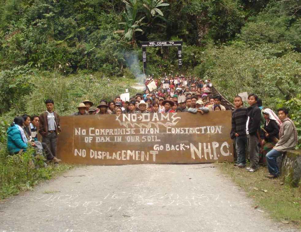


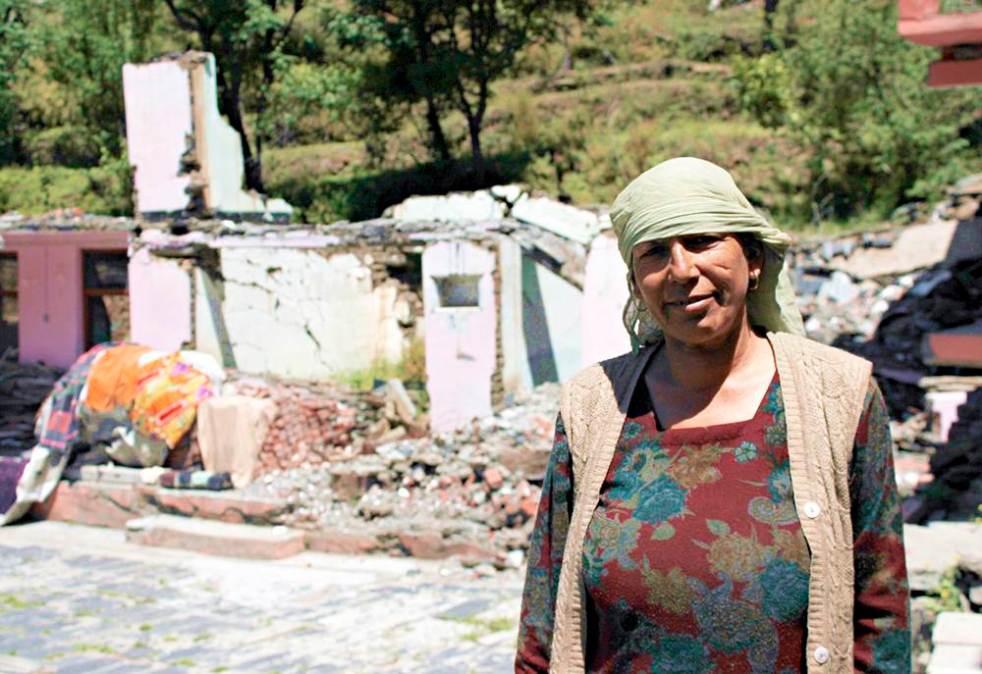


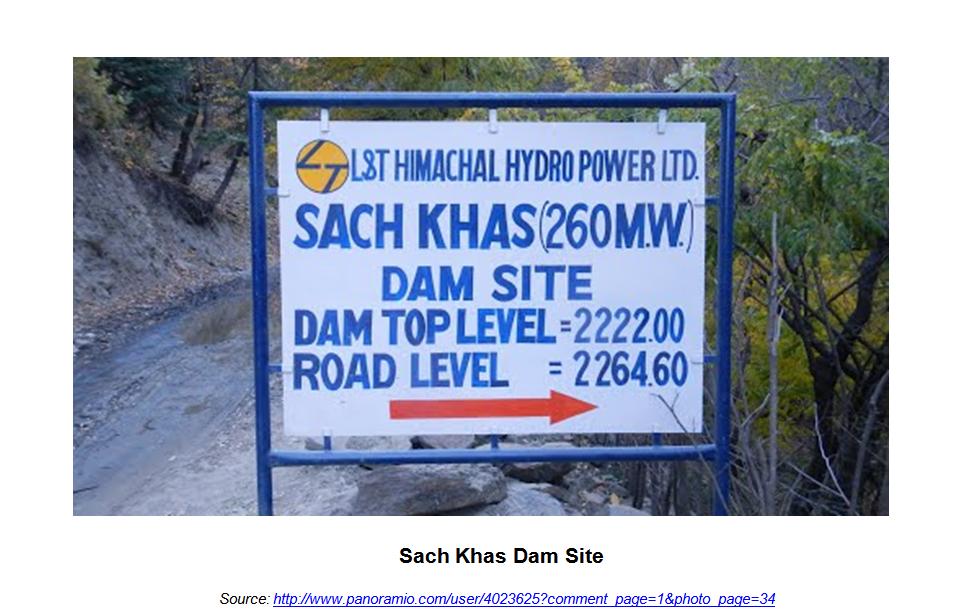


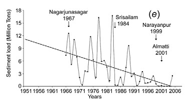
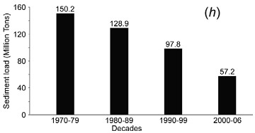
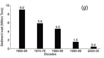
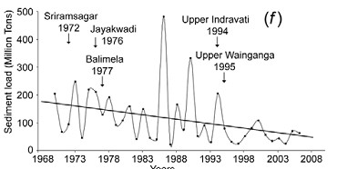

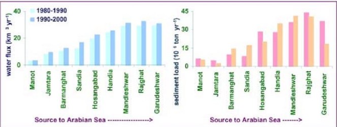
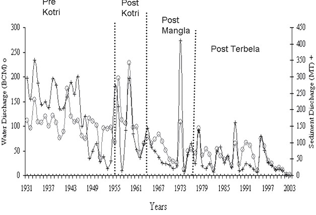

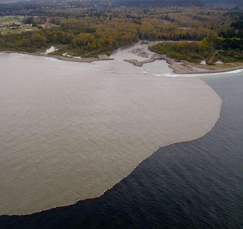

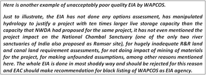


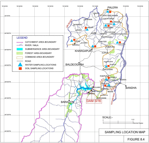


 The Simang River is a tributary of the Siang River which originates at an elevation of 2950 m. The river is 44 km long (as mentioned in the EIA/EMP reports done by consultant R S Environ Link). Total catchment area of Simang River is 554 sq km. There are two projects proposed on the Simang River. The first one is Simang I with an installed capacity of 67 MW (3 x 22.33 MW) and catchment area of 494 sq km. The second one is the upstream project Simang II with an installed capacity of 66 MW (3 x 22 MW) and catchment area of 422 sq km. These two projects were jointly discussed in the 19th meeting of EAC in October 2008 for the first time. Then these projects were subsequently discussed in the 21st, 36th, 66th and 67th meeting of EAC. A diagram of the two projects on the Simang River is given below.