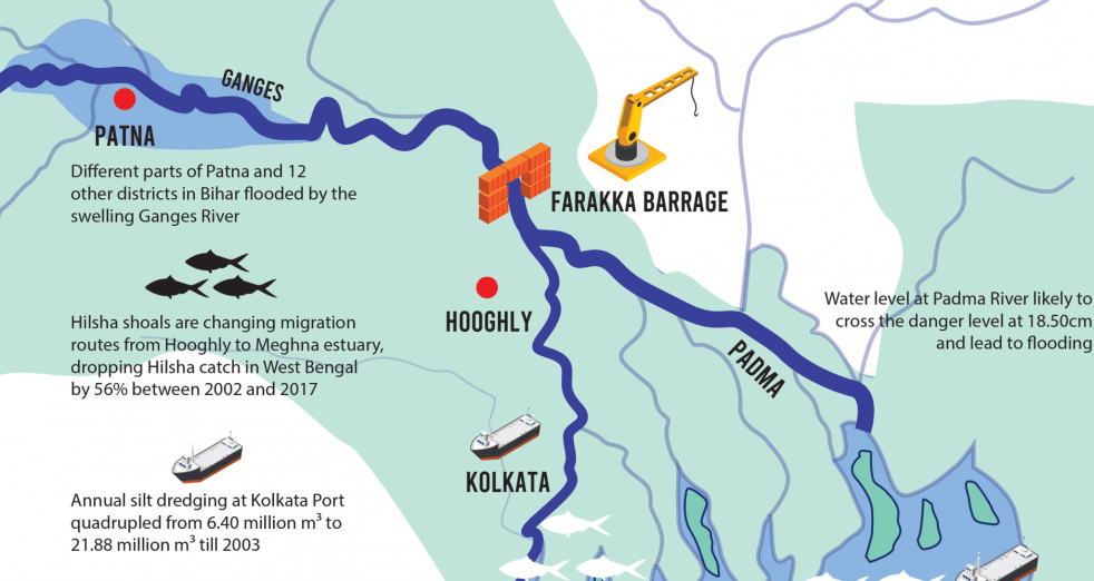
(Feature Image: Infographic taken from Farakka now boomerangs on India: Source: TBS News, Oct. 2019)
The 2304 m long Farakka dam on Ganga in Murshidabad district in W Bengal was commissioned on Apr 21 1975 and completes 50 years today. The dam needs an independent review to assess the costs, benefits and impacts of the dam, both projected and actual and to decide about the need and form of its continued existence.
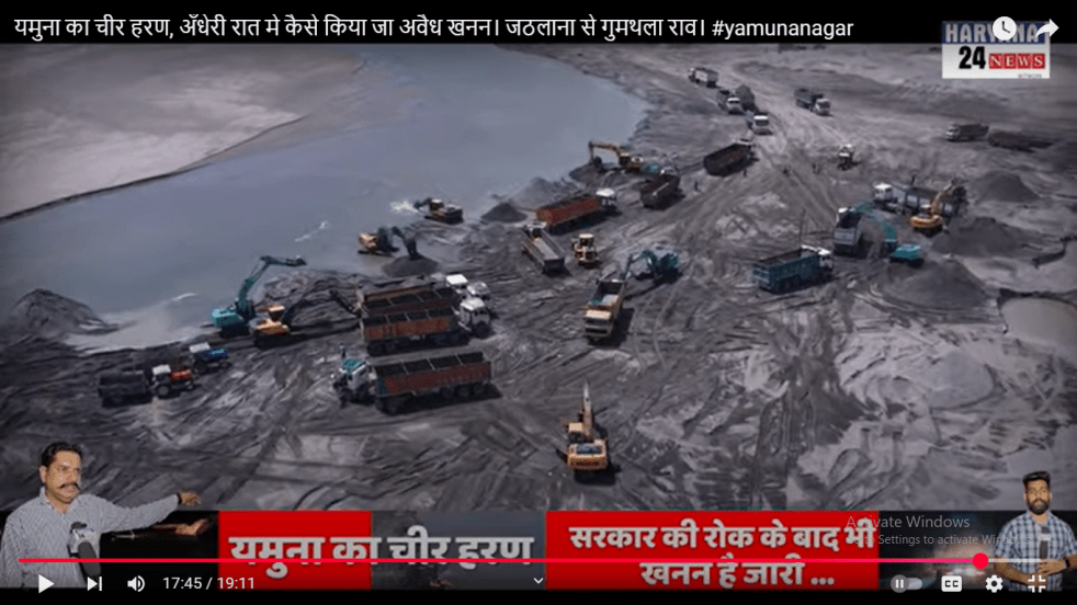
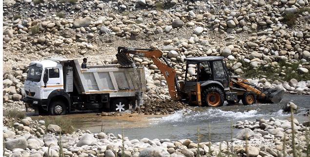
(Feature Image: Screnshot of Haryana 24 News exclusive report on illegal mechanized sand mining in Yamuna river at Gumthala ghat near Yamuna Nagar-Karnal border of Haryana in May. 2024.)
हरियाणा राज्य के करनाल और यमुनानगर जिलों में वरयाम सिंह एक जाना-माना नाम है। आप पेशे से जिला न्यायालय और पंजाब एवं हरियाणा उच्च न्यायालय में अधिवक्ता हैं। आप यमुना नदी के किनारे स्थित गुमथला गांव में रहते हैं जहाँ आपके प्रयासों से इंक़लाब मंदिर स्थापित है जो देश के स्वतंत्रता सेनानियों को समर्पित है और राज्यस्तर पर प्रसिद्ध है। क्षेत्र में विकास कार्यों में पारदर्शिता एवं सरकारी विभागों के कार्यों में सुधार लाने के लिए आपने हरियाणा एंटी करप्शन सोसाइटी की स्थापना भी की है और आप इन उद्देश्यों के लिए जन सूचना अधिकार कानून का बखूबी इस्तेमाल करते हैं।
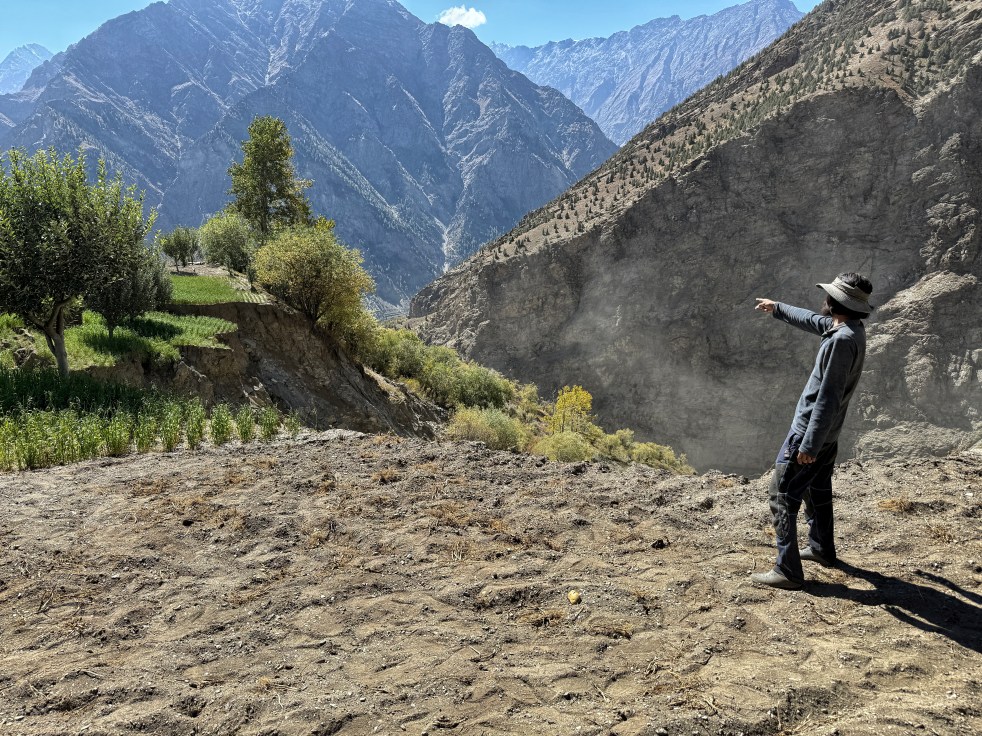
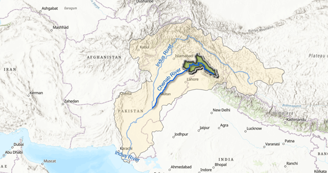
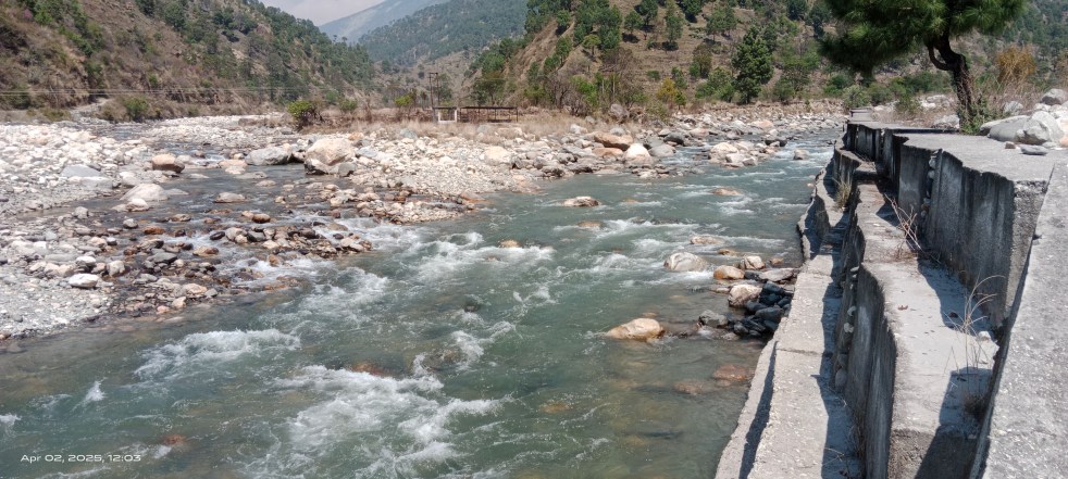
At the village of Jasrath in Lahaul and Spiti, the River Chandrabhaga’s current is swift and strong like a rambunctious toddler. The river is new here, birthed just 16 kms upstream at the confluence of the Rivers Chandra and Bhaga. Chandrabhaga will be named as Chenab only after a journey of about 400 kms downstream. Chenab is one of the largest tributaries of the River Indus whose expansive basin feeds over 250 million people in the heart of Asia.
Lahaul and Spiti district in Himachal Pradesh is a cold desert with very little rain, but the narrow ribbons of land along the Chandrabhaga are emerald with willows, apple orchards and cultivated farms. This is precious land.
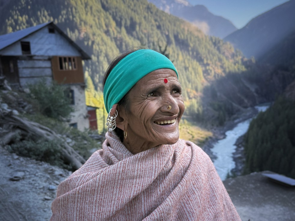
Chenab, which translates as the Moon River is the largest of the five tributaries of River Indus. It flows for about 974 kilometers from the High Himalayas of Lahaul to the forests of Jammu and Kashmir and onto the plains of Pakistan. Its main tributaries in India include Miyar, Marusudhar and Tawi. In the vast plains of Punjab in Pakistan, it is met by Jhelum, Ravi and Sutlej to form the mighty Panjnad before it meets the Indus. Its catchment, spread across 67,430 km2, is shared between the two countries.
Chenab is Chandrabhaga (Crescent Moon) in its headwaters. It was the River Asikni in Rigveda, and the Acesines for the ancient Greek. From sparse mountain settlements of Lahaul to the bustling urban centers of Sialkot, more than 10 million people live and prosper along the Chenab. Hydropower projects operational and under constructions on the river have an installed capacity of more than 5000 MW (Central Electricity Authority 2024), and its canals irrigate hundreds of thousands of acres in Pakistan and India (Shakir et al).
(Feature Image: Skymet predicts normal monsoon with 103% rainfall of the long-period average. Source: Business Today)
The private forecasting agency Skymet has forecast Normal SW Monsoon rainfall across India on Apr 8, 2025, a week before IMD comes out with its forecast. This advance forecast by private agency, compared to IMD raises question as to how come the private agency with much more limited resources is able to achieve this.
In any case, the forecast of about 3% above normal rainfall in June Sept 2025 is welcome. The rainfall distribution forecast, both across the four months and across the four regions is also good if it comes true.
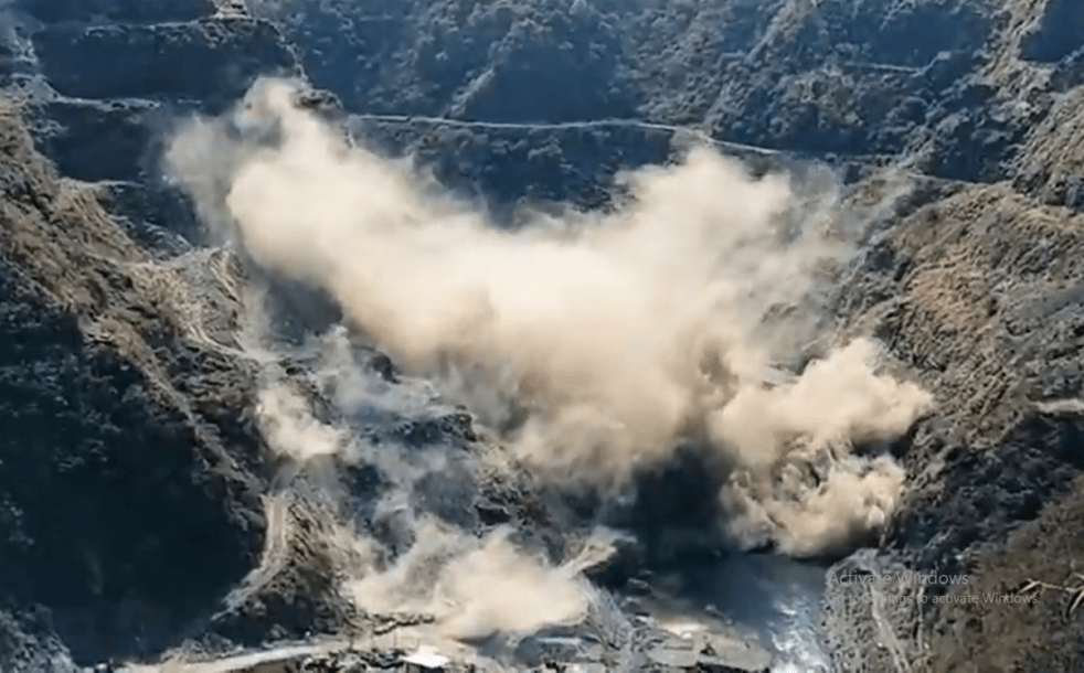
Feature Image: Screen grab of social media video shows scale of impact of heavy blasting work at Lakhwar dam on 07 April 2025)
A viral social media video media shows the frightened impact of a huge scale blasting work done for building the main structure of controversial Lakhawar dam on Yamuna river in Dehradun district, Uttarakhand. As per the locals, the blast took place in the morning hours of April 07, 2025, and caused shaking of hills to a large extent apart from blocking the flowing course of river with enormous debris for several hours forcing the project authority to employ heavy machines to clear the blockage.
The social media post shared with the video mentioned that the heavy blast scared the birds in the area and questioned how the company was allowed to destroy the entire hill environment. The heavy blast has indeed created havoc for the aquatic life in the river and downstream projects.
Increasing incidences of Glacial Lake Outburst Floods (GLOFs) are being experienced in the Indian Himalayas. One of the most notable examples of GLOF was the Chorabari Lake GLOF that occurred on 16th June 2013 in Kedarnath, Uttarakhand[1] which was triggered by heavy rainfall induced mass movements into the lake. The GLOF devastated villages of Kedarnath, Rambara, and Gaurikund. Around 6,000 people were officially killed, and a significant number of the deaths were linked to the GLOF. Countless bridges and roads were washed away, and about thirty hydropower plants were affected or completely devastated. Several Hydropower projects resulted in exponential losses to life and livelihoods. Whole of Uttarakhand was affected in the disaster, and a significant proportion of it was related with GLOF.
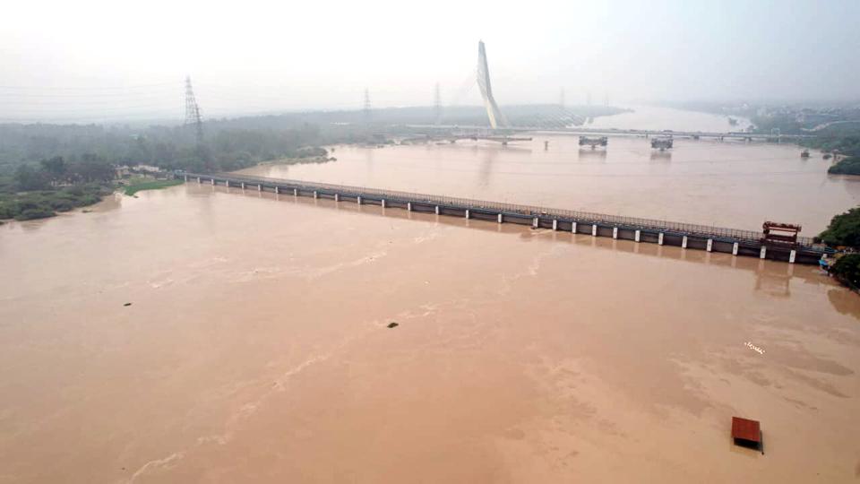
(Feature Image: A view of overflowing Yamuna river at Wazirabad in New Delhi on 13 July 2023. Credit: HT_PRINT/Source: Live Mint)
Post July 2023 unusual flood spell in Yamuna river reaching unprecedented levels in Delhi, the Ministry of Jal Shakti (MoJS) on August 06, 2023, constituted a committee for conducting a “Joint flood management study of river Yamuna for its reach between Hathnikund and Okhla Barrage”. The Committee headed by Chairman, Central Water Commission (CWC) & Ex-Officio Secretary to Govt of India with members from Haryana, Uttar Pradesh, NCT of Delhi and expert Organizations was mandated to examine the meteorological aspects, return period of floods, discharging capacity of barrages, functional requirement of ITO barrage, etc.
(Feature Image: Merging point of of Badiyar gaad (left) and Yamuna river (right) at Gangani in Badkot, Uttarakhand. BS Rawat/SANDRP)
New research published this week reveals a startling change: the oxygen levels in inland waters has been dramatically reducing since 1900, due to human activities including big dams and pollution. This condition leads to dead fish, collapsing food chains and reducing water quality, among other impacts.
There are simultaneous processes ongoing in inland waters leading to production and consumption of oxygen. The location and processes for both the production and consumption of oxygen has been changing during 1900 to 2010. The Global oxygen consumption in inland waters, net of production has gone up by over 100% from 0.26 Pg/year in 1900 to 0.53 Pg/ year in 2010. While earlier climate change was considered major contributor to this reduction, new research shows it is big dams and pollution that are much bigger contributors. Inland waters now pull nearly 1 billion tons of oxygen from the atmosphere every year — half as much as the entire ocean emits back.
(Feature Image: Taken from a report titled “Mining in Nallah Romeshi: DMO Pulwama submits report” by Rising Kashmir, 04 Dec. 2024)
When it comes to environmental issues in Kashmir, the Srinagar based Dr. Raja Muzaffar Bhat dons many hats. He is an independent researcher, often tracking river courses, glacier zones and forest lands to gain firsthand insight into the unfolding impact of changing climate, land use on water sources, rivers and people. He is a writer with clear thoughts articulating concerns over ongoing environmental degradation in the region.