(Feature Image: Mud, debris following flashfloods at Dharali)
The following Indian Express report highlights some key aspects of the Oct 2020 guidelines from the National Disaster Management Authority related to disasters caused by Glacial Lake Outburst Floods (GLOF). Unfortunately, as is clear from the recent Dharali disaster most key aspects of the guidelines remain unimplemented almost five years after the Guidelines were published. Had they been implemented with any seriousness, the proportions of the Dharali disaster would have been significantly reduced.
What is the use of such guidelines if there is no seriousness in ensuring their implementation? Who is responsible for its implementation? What has NDMA, CWC and the concerned governments of Himalayan states done to implement these guidelines with any seriousness? Who is to be held accountable for their non-implementation?
Will NDMA at least NOW come out with a time bound action plan for their implementation and also create mechanism for accountability for non-implementation?
NDMA Guidelines on GLOFS In October 2020, the NDMA had issued detailed guidelines on ways to deal with disasters caused by Glacial Lake Outburst Flood (GLOF). The National Remote Sensing Centre (NRSC) had completed a project during 2011-15 on “Inventory and Monitoring of Glacial Lakes/ Water Bodies in the Himalayan Region of Indian River Basins”, sponsored by the Climate Change Directorate of the Central Water Commission (CWC). It was observed at the time that there were 352, 283, and 1,393 glacial lakes and water bodies in the river basins of the Indus, Ganga, and Brahmaputra respectively.
The NDMA guidelines say that risk reduction has to begin with identifying and mapping such lakes, taking structural measures to prevent their sudden breaches, and establishing mechanisms to save lives and property in times of a breach.
One such landslide that occurred along the Phuktal river, a tributary of the Zanskar river, on December 31, 2014 about 90 km from Padum in Kargil district of Ladakh, led to the blockage of the river and eventually a potential flood situation on May 7, 2015. The NDMA created an Expert Task Force drawn from various organisations, which, along with the Indian Army, used controlled blasting and manual excavation to clear the landslide debris and channel the water from the dammed river.
According to NDMA, work on building a robust early warning system (EWS) and a broad framework for infrastructure development, construction, and excavation in vulnerable zones is still continuing. “In contrast to other countries, there are no uniform codes for excavation, construction, and grading codes in India. Restricting constructions and development in GLOF/ LLOF prone areas is a very efficient means to reduce risks at no cost,” the NDMA guidelines said.
According to the NDMA, no construction of habitation should be allowed in the high-hazard zone. “Existing buildings are to be relocated to a safer nearby region and all the resources for the relocation have to be managed by Central/ State governments. New infrastructure in the medium hazard zone have to be accompanied by specific protection measures,” it said.
NDMA has also emphasized that land use planning which avoids the hazards and minimizes the risks is the most effective and economical way to reduce losses caused due to landslides. “There are no widely accepted procedures or regulation in India for land use planning in the GLOF/ LLOF prone areas. Such regulations need to be developed concerning the increased risk of future GLOF/LLOF events. …There should be monitoring systems prior to, during, and after construction of infrastructure and settlements in the downstream area,” it has said.
“Experience has shown that over 80 per cent of search and rescue is carried out by the local community before the intervention of the state machinery and specialised search and rescue teams. Thus, trained and equipped teams consisting of local people must be set up in GLOF and LLOF prone areas,” the NDMA has said. These local teams, it has said, will assist in planning and setting up emergency shelters, distributing relief packages, identifying missing people, and addressing the needs for food, health care, water supply and sanitation, education, etc. They will also be useful in identifying the most vulnerable people who may need special assistance following the disaster.
The NDMA has also called for comprehensive alarm systems. “Since GLOFs are very fast processes, an evacuation must be executed within a very short time, [which] requires an alarm infrastructure, clear protocols for all involved actors, and capacitation of the involved population and authorities. Besides classical infrastructure [such as] acoustic alarms by sirens, modern communication technology using cell phones can [be used],” the NDMA has said.
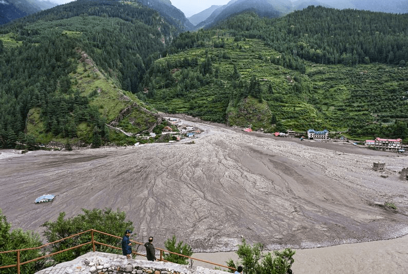
Dharali Disaster in Uttarakhand: Yet another wake-up call The Dharali tragedy has yet again brought to the spotlight the perils of unplanned construction in the ecologically sensitive Himalayan region. The trigger for the burst of glacial pond or lake upstream of Dharali was possibly a combination of snowmelt and rainfall. But the fact is this waiting-to-explode disaster situation prevailed for long, but was not even under our monitoring radar.
Kheer Gad River’s occupation of the old course during the disaster should remind us that we can and must change the course of so called ‘development’ along rivers. We have highlighted several such disaster-prone sites in the Chenab Basin recently. The fact that army jawans are also missing in this disaster should remind army that it too needs to be careful about encroachments and constructions in the path of the river. Let us hope our governance wakes up sooner rather than later. And that an independent assessment of this disaster is instituted soon once the rescue and relief phase is over.
SANDRP has described the debris-laden flash flood that struck Dharali on August 5 as a catastrophe whose scale was amplified by human actions and governance failures. It has urged an independent assessment once rescue and relief work is over.
Himanshu Thakkar of the South Asia Network on Dams, Rivers & People, (SANDRP) echoed the need for technological advancements but stressed the importance of effective disaster management systems to act on early warnings. “This will be a combination of Doppler radars, satellite monitoring, river-based ground monitoring, and more intense monitoring in identified vulnerable locations,” he said. “More importantly, we need a disaster management system that can use such advance information to remove people in time from vulnerable locations. We have a long way to go on this,” he added. Mr Thakkar also called for robust governance mechanisms, including “honest, credible environment and social impact assessments of all major interventions, independent appraisals, confidence-inspiring monitoring, and compliance systems” to ensure accountability. “We are pretty poor in all these aspects,” he noted.
Unplanned Development Amplifies Disaster Impact The flash floods in Uttarkashi, particularly in areas like Dharali, were exacerbated by unplanned development, including the proliferation of hotels and homestays encroaching on river paths. Mr Thakkar highlighted the absence of policies to regulate such constructions.
“We have no system to ensure that hotels, homestays, and other civil constructions are not encroaching on the path of rivers and streams. There is no system to remove such encroachments, and no assessment of the amount of space a river needs considering the current rainfall pattern and catchment health,” he said.
He pointed out that major projects like dams, hydropower plants, highways, railways, and urban centers contribute to environmental degradation by dumping muck into rivers, while schemes like riverfront developments and floodplain encroachments further constrict waterways. “The health of our catchments is degrading, which means rainfall is quickly converting into flow. That, combined with intensification of rainfall, means rivers need greater waterway, not smaller,” Mr Thakkar explained.
Dr Rajeevan also stressed the need for regulatory reforms, urging stricter controls on construction and tourism. “They are really spoiling the environment and river flow,” he said, advocating terrain-specific hazard zoning and land-use policies to balance tourism with ecological safety.
Integrated Flood Management for Resilience With cloudbursts becoming more frequent in Uttarakhand, potentially linked to climate change, experts underscore the need for integrated flood management strategies to enhance resilience, especially in high-altitude villages like Dharali. Mr Thakkar emphasized a combination of early warning systems, policies ensuring sufficient river waterways based on current and projected rainfall patterns, and robust monitoring and disaster management systems. “Most importantly, we need independent assessments that will provide information for accountability mechanisms,” he said, advocating for post-disaster independent reviews to learn lessons and fix accountability.
While acknowledging the role of climate change, Thakkar cautioned against using it as an excuse for poor governance. “The science of attribution is still being developed and today is not good enough to provide direct attribution. But climate change science tells us that in every such event of intensification of rainfall, there is a footprint of climate change,” he said.
“However, climate change should not be used as a carpet under which we can push all kinds of accountability and misgovernance. We know these events are increasingly likely, and we better be prepared for them rather than blaming it on climate change.”
Young mountains, seismic activity, pronounced slopes, fragile geology, abundant rainfall, monsoon climate, glaciers (…) all this is part of the reality of the Himalayas. This fragile geology requires comprehensive studies to closely identify and monitor vulnerable areas, explains the coordinator of the South Asian Network on Dams, Rivers and People, Himanshu Thakkar, to EFE. The glaciers are melting, the glacial lakes form and are fragile. When they collapse, they can create massive flooding downstream in a very short time, Thakkar explains.
Thakkar denounces that there are no effective mechanisms to prevent hotels and other settlements from invading natural channels. Expansion, rather than adapting to the terrain, occupies and conditions it, exposing millions of people. That, coupled with the intensification of the rains, implies that rivers need more space, not less, which is what we are trying to give them, he adds. Beyond the climate: is it possible to prevent collapse?
For Thakkar, it’s not enough to blame climate change. The authorities, he points out, have been aware of the risk for years, but have not taken proportional measures. Knowing that disasters will be more frequent, the least we should do is prepare for them. Among the priorities, the expert mentions early warning systems that integrate meteorological and glacial data, independent environmental impact studies and, above all, accountability mechanisms – that allow you to learn from each disaster and assume responsibilities. Every tragedy, he concludes, is a failure of the system, not just an act of nature.
“The force of the flood caused the river to burst its banks, but it also flowed back into its old channel and into the plain between the two channels. Several buildings were erected in these areas, which should never have been allowed, as rivers often change their course in the Himalayas. These kinds of floods are increasingly likely today, but they turn into disasters because of these human errors,” explains Himanshu Thakkar, engineer and coordinator of the SANDRP.
This report also referred to Himashu Thakkar comments shared in NDTV report. Uttarkashi flash floods in Dharali village: The recent devastation has been compounded by unregulated development, particularly the proliferation of hotels and homestays encroaching on river channels. The cause of the flash flood is still unclear, though experts have proposed several possible triggers. (Kavita Upadhyay) Himalayan disasters result of large-scale ecological ruin justified as essential for progress. (Bharat Dogra)
The govt has not yet confirmed whether the incident was caused by a cloudburst, a glacial lake outburst flood (GLOF), or a combination of several factors such as avalanche, landslides, heavy rainfall or cloudbursts. This situation mirrors the devastating Kedarnath disaster of 2013, one of the worst natural disasters in recent Indian history. ISRO’s analysis indicated that the 2013 disaster was caused by a combination of heavy rainfall, glacial lake outburst floods and landslides, all exacerbated by unplanned infrastructure development.
Experts from the National Disaster Management Authority (NDMA) have said they were examining the possibility that a glacier collapse upstream of the channel feeding the Kheer Ganga triggered the floods. Satellite images confirmed the presence of significant glaciers and at least two glacial lakes situated directly above the affected site.
HYDRO POWER PROJECTS
CEA: SLHEP is vulnerable, needs EWS The Central Electricity Authority (CEA) has identified the 2,000 MW Subansiri Lower Hydroelectric Project (SLHEP) as ‘vulnerable’, and issued an advisory to the NHPC for implementing an Early Warning System (EWS) in the project. “Hydroelectric power projects located generally above elevation of 1,500 metres and which are first in the basin in the upper reaches of the Himalayan region” have been identified as vulnerable by the CEA. “For such hydroelectric power projects, it is mandatory to implement an EWS. An advisory has also been issued by the CEA to all the developers of identified vulnerable projects for implementing EWS in these projects,” Minister of State for Power Shripad Naik said in the Lok Sabha on Aug. 7.
The minister said that Rangit (60 MW) HEP in Sikkim, Panyor Lower (405 MW) HEP and Kameng (600 MW) HEP in Arunachal Pradesh, Chuzachen (110 MW) HEP, Tashiding (97 MW) HEP, Rongnichu (113 MW) HEP, Dikchu (96 MW) HEP and Teesta III (1,200 MW) HEP in Sikkim have also been identified as sensitive.
LOP Saikia asks centre to address Assam’s concerns on Dibang Project The Leader of the Opposition in the Assam Legislative Assembly, Debabrata Saikia, has urged Union Power Minister Manohar Lal to halt further progress on the Dibang Valley Hydro-Electric Project in Arunachal Pradesh until all downstream concerns of Assam are thoroughly addressed. In a letter to the Union Minister, Saikia highlighted the negative experience with the Lower Subansiri Hydro-Electric Project, which faced years of mass protests in Assam due to unaddressed safety, environmental, and livelihood concerns. He warned that overlooking similar issues in the much larger and ecologically sensitive Dibang project could trigger widespread public opposition and erode trust in the government. “If past mistakes are repeated, the project may again face prolonged opposition and risk losing public trust,” he stated.
Saikia pointed out that the districts of Dhemaji, Tinsukia, and Dibrugarh are particularly vulnerable to the impacts of upstream hydropower development. He presented a five-point demand to the Union Government: (1) Inclusive Public Consultations in all affected districts, conducted in local languages and involving grassroots stakeholders; (2) Independent Cumulative Impact Assessment of the Dibang and other upstream hydropower projects; (3) Formal Consent from the Assam state government and involvement of downstream district administrations in project planning; (4) Structural Safety Reviews that account for seismic risks, dam-break scenarios, and climate impacts and (5) Advance Mitigation Measures, including early warning systems, flood management strategies, disaster compensation plans, and continuous ecological monitoring. Saikia also cited the Assam Assembly’s 2010 House Committee recommendations and the report of the Technical Expert Committee led by Dr. C.D. Thatte and Dr. M.S. Reddy as key references for making informed and responsible decisions regarding the project.
He added, “Learning from the Lower Subansiri experience is critical for establishing a transparent, cooperative, and scientifically informed approach to hydropower development in the North East. The aspirations and anxieties of the people of Assam must be respected in letter and spirit. A just, inclusive, and ecologically balanced decision will go a long way in reinforcing cooperative federalism and environmental justice.”
Arunachal can learn from Himachal’s disastrous path Arunachal and Himachal stand at a critical juncture. Arunachal’s hydropower ambitions, articulated by Chief Minister Khandu, risk replicating Himachal’s ecological collapse, where 94 deaths and billions in losses exposed the consequences of unsustainable development. The Supreme Court’s warning of Himachal’s potential “disappearance” serves as an urgent call for Arunachal to embrace sustainable practices. By prioritizing demanding assessments, forest conservation, community engagement, and healthy oversight, both states can safeguard their Himalayan heritage and ensure a resilient future. (KK Chatradhara)
Siang river, people at crossroad Caught between two powerful nations and their geopolitical moves for dominance, the people of the Siang valley and their river are now at a crossroads. (Tongam Rina)
Corruption in Himachal Hydro Former Managing Director ((HPSLDC)) and patron of the All-India Power Engineers Federation, Er. Suneel Grover, has levelled serious allegations of corruption and abuse of authority against the current Chairman of Himachal Pradesh State Electricity Board Ltd, Sanjay Gupta. In a letter addressed to Chief Minister Sukhvinder Singh Sukhu, Grover has sought a high-level vigilance inquiry and demanded Gupta’s immediate removal, accusing him of misusing his post for personal vendetta and financial irregularities. The letter goes on to highlight past criminal cases involving Gupta, citing “three FIRs in his name, one in 1996 and two in 2009.” It refers to an incident where “in one case Rs 3.00 lakh was recovered from his vehicle and he was arrested.”
Himdhara’s multimedia compilation Himachal Pradesh’s monsoon disasters. While the hazard prone nature of the Himalayan region and the climate crisis are undeniably important factors, the overwhelming focus on them conceals critical issues.
This interrogates how infrastructural expansion, socio-ecological degradation, regulatory failure and technocratic ‘solutions’ have created compounded vulnerabilities and disaster risk in the state in recent years. It spotlights the Kullu Valley: home to the headwaters of the Beas River, and one of the most severely affected regions for three consecutive years.
At the end of the 4 section blog is the link to a video documentary that brings forth local voices: https://youtu.be/KCLrdWweQSA?si=AoRb8OhssFD5yAtd
The documentation, analysis and editing is based on site investigations, interviews, RTI applications and intensive desk research carried out over the period of over a year done with scarce resources and a highly committed team comprising – Sumit, Prateek, Upkar and Manshi Asher.
Disaster in making in Sainj Valley Kala cho hills in Bhupan village under Raila Panchayat in Sainj valley of Kullu district has faced cracks and landslides. Shooting stones from the hills are falling in the village stream. In 2023, the hill witnessed landslide without rain. The villagers allege that the NHPC’s Parbati HEP tunnel construction has already dumped huge amount of muck in village stream. They also blame NHPC for negligence in muck dumping and its blasting work for weakening the hills. Villagers fear that this could become a recipe for disaster in coming days.
Karnataka Sharavathi PSP moves forward inside a wildlife sanctuary, despite environmental red flags and pending clearances.
DAMS
Kaleshwaram Project Ghose Panel Key findings Stating that cabinet approvals were not taken for the three critical barrages — Medigadda, Annaram and Sundilla — Justice (retd) PC Ghose’s one-man commission has come down heavily on the procedural violations, faulty planning, inflated estimates and irregular approvals that dogged the Kaleshwaram project.In its scathing 650-page report, the panel found fault with virtually every aspect of the barrages, including site selection, execution, quality control, financial sanctions, operation and maintenance.
Calling the project a case of “rampant and brazen procedural and financial irregularities,” the commission concluded that what was touted as Telangana’s lifeline had turned into a colossal waste of public money due to a complete breakdown of governance, planning, technical oversight and financial prudence, driven largely by individual discretion and political interference.
The panel noted that the administrative approvals granted on March 1, 2016 (GO Nos. 231, 232 and 233) were neither placed before nor ratified by the state cabinet. Instead, they were unilaterally approved by the irrigation minister and the chief minister, in clear violation of government business rules. The commission flagged further irregularities: KCR wrote to Prime Minister Narendra Modi pegging the project cost at ₹71,436 crore without a finalised detailed project report from WAPCOS. The specially created SPV, Kaleshwaram Irrigation Project Corporation Limited, meant to oversee implementation and financial oversight, merely acted as a loan-raising entity, it said.
Design-wise too, the barrages were flawed — built on permeable foundations and used as storage structures against best engineering practices. Critical studies like backwater, tailwater and geophysical surveys were not conducted at Annaram and Sundilla, and designs were made “without proper studies and inexplicable delay,” the commission found.
The report also found design deficiencies in that the barrages that were designed as permeable foundations were “utilised as storage structures”, which is against standard practice. The barrages were also kept at full capacity throughout to lift water through pumps, even as the barrages “were diversion structures and not storage structures”. Running the barrages at full capacity seemed to have caused the distress, the commission noted.
Rs 612 Cr excess payments made to L&T, others “Post-tender inclusion of price adjustment clauses in five agreements led to an avoidable payment of price escalation of Rs. 1,342.48 crore. Other inflated rates, undue benefits/excess payments to contractors, including L&T company, amounted to Rs. 612.51 crore”, the Ghose Commission report said. The panel has asked the govt to investigate this.
The Ghose Commission report included an analysis of the escalation of the project cost from Rs 38,500 crore to Rs 71,436 crore for Kaleshwaram (as per CM’s letter in 2016), and later saw revised administrative approvals totalling over Rs.1,10,248.48 crore by March 2022. The Commission also pointed to the Expert Committee’s view that shifting of the project from Tummidihetti to Medigadda would render “approximately Rs. 6,000 crore” of work already done as “infructuous”, plus an additional Rs. 1,500 crore for tunnel lining/filling, and extra land acquisition cost.
Is it curtains for Kaleshwaram? The Justice PC Ghose Commission which investigated into the irregularities in the construction of the Kaleshwaram project and misuse of public funds, found fault with the shifting of the location in the first place! This clearly shows that the fate of one of the biggest lift irrigation schemes in India is hanging in the balance now. Under these circumstances, the recommendation of the National Dam Safety Authority (NDSA) to the state government that it should go for repair of the sunken piers of Medigadda, and cracks developed in Sundilla and Annaram barrages will remain non-starter. The state government has also reportedly concluded that the project has turned into a non-performing asset and a white elephant for the state exchequer.
The question of the existence of the Medigadda barrage is also crucial in the wake of the Congress government’s proposal to construct a barrage at Tummidihetti by redesigning the project as per the earlier proposal of Pranahita Chevella Lift Irrigation Project, which will require Maharashtra’s agreement due to submergence in that state. Some experts see the Ghosh commission report as political rather than technical.
Cabinet clears probe report: CM A. Revanth Reddy on Aug 05 said that the Cabinet has approved the Justice P.C. Ghose Commission report on the Rs 1.1 lakh-crore Kaleshwaram Lift Irrigation Scheme. The report will be tabled in the Assembly and the Council for a thorough debate, allowing all political parties to provide their inputs on it. The CM said that action against those held accountable by the Commission for irregularities in the project will be taken after deliberations in the Legislature. The Irrigation Minister Uttam Kumar Reddy said the Ghose commission “clearly says KCR acted not as CM but as an administrative head issuing direct orders that went against institutional processes.”
The commission, apart from pointing out lapses and negligence in the construction of three barrages, came to a conclusion that “the contracts were awarded illegally, estimates were revised maliciously by making undue favours to the agencies and extension of time was given collusively”. L&T constructed the Medigadda barrage, while Afcons built Annaram and Navayuga Sundilla. The commission named 19 officers and engineers, including former chief secretary SK Joshi and Smita Sabharwal, and said they were “liable for action”.
Did Sardar Patel really envision the Narmada Dam? It is clear from this article by a senior Gujarat Journalist that Sardar Patel never suggested or proposed building a big dam on Narmada in Gujarat. Great to see this.
DAM SAFETY
Singur Dam at risk of collapse The Singur dam may collapse “anytime” with a very real and serious threats of its embankments getting breached, resulting in huge loss of life, a state dam safety review panel (DSRP) report on the conditions at the M. Baga Reddy Singur Project has warned. It said urgent repairs are necessary. The Singur dam, designed to hold 29.91 tmc ft of water, and located upstream of Manjira reservoir, supplies around 6.96 tmc ft to Hyderabad. The breach would also have severely adverse impacts on the downstream Manjira Dam.
An inspection by members of the specially constituted DSRP in June found, among other serious issues, that the entire earthen bund had developed several vertical cracks which must be repaired immediately. One of the reasons for the current state of the dam, the DSRP indicated, was the excessive storage of water at the dam beyond its rated capacity in 2017 to provide water supply to the Mission Bhagiratha scheme. The report said “due to excessive storage, major areas like upstream revetment could not be repaired and maintained to the original designed slopes… If the disturbed upstream revetment is not rehabilitated urgently, a breach in the earthen embankment may happen anytime.”
Though the report was polite in stating “the downstream apron portion of the spillway needs some attention,” it pointed out that the apron portion, where the water leaving the ski jump can have a negative impact, “possibly got damaged” and that a “huge amount of dislodged and fragmented rocky blocks are found dumped in the river bed, just downstream of the spillway.” The report said during their inspection, the DSRP members “learnt that the designed apron was not provided at the immediate downstream of the spillway and the foundation rock was left exposed. As a result, it is possible that the bedrock in the apron portion of the spillway is getting affected and may pose a risk to the dam” and its related structures.
PAC warns about release of water from Bhakra-Pong dams The Public Accounts Committee (PAC) of Punjab citizens have asked the authorities to remain alert in the discharge of water to avoid a repeat of the Aug 2023 events. At that time, a large quantity of water was discharged from the Bhakra and Pong dams without any warning, leading to floods in various parts of Punjab. Recalling the events of 2023, PAC member Jaskirant Singh said that on Aug 16 that year, 84,000 cusecs of water was suddenly released in the Satluj from Bhakra and 142,000 cusecs in the Beas from Pong, due to which Punjab faced floods.
INTERLINKING OF RIVERS
Gujarat Tribals to again protest Par Tapi Narmada Proposal Reviving protests against Par-Tapi-Narmada river-linking project in South Gujarat after a gap of three years, a rally has been announced in the Dharampur area of Valsad on Aug 14. Over 5,000 people of tribal communities from affected regions are expected to take part. The protest was revived after a detailed project report (DPR) was mentioned in Parliament. “Ahead of the 2022 assembly election, chief minister Bhupendra Patel declared the project scrapped during his visit to Surat in May. However, now a DPR has been mentioned in the Lok Sabha and thousands of tribals have been forced to restart the protest for survival,” said Anant Patel, Congress MLA from Vansda. In South Gujarat, a large part of Dang and Valsad will be impacted due to the network of dams and canals. “Earlier, seven dams were planned, but now two more dams have been added in the DPR details. Nearly 30,000 families will be affected. Their villages, farmland, and livelihood will be submerged in dam water,” added Patel.
INTERSTATE WATER DISPUTES
Mahadayi water tribunal gets year’s extension After giving back-to-back extension to two water disputes tribunals, Centre has extended the tenure of a third one, the Mahadayi Water Disputes Tribunal, as well for a period of one year with effect from Aug 16. Constituted in Nov 2010 for adjudicating the dispute over river water sharing among Goa, Maharashtra and Karnataka, the tribunal has had the third longest tenure among the four active water disputes tribunals in the country, which continue to get extensions year after year, as they have not been able to resolve the long-pending disputes. The last extension to the Mahadayi tribunal was granted in Feb for a period of six months but, ahead of expiry of its term, it requested Centre to extend the timeline for submission of its further report by one year.
URBAN RIVERS
Ganga Drowns the concrete dreams of Varanasi Prime Minister Narendra Modi’s parliamentary constituency, Varanasi, was envisioned by the Central government as a model Smart City, with majestic ghats, gleaming alleys, and modern development. But the city could be engulfed in terrifying floods with just a modest spell of rain. Years of construction aimed at developing the Vishwanath Corridor and the Namo Ghat have choked the river and left no place for the floodwaters to go except through Varanasi’s streets and ghats.
Many areas of the city are inundated. Some residents have left their homes to go stay with relatives, while others have taken shelter on their own rooftops—refugees in their own homes. Boats have replaced vehicles in several lanes. The cremation ghats, Manikarnika and Harishchandra, are now under water. Hundreds of temples have shut their doors. Where once the sacred aarti echoed, now there is only silence. The new ramp and sewage pumping plant being built at Manikarnika are now submerged beneath the floodwaters.
The floodwaters have now reached Ramnagar Fort, Sujabad, Domari, the Maharshi Vedvyas Temple, and the surrounding areas of Varanasi. Temples are closed. Rituals have ceased. Faith is sinking. A tragic outcome of reckless development. Varanasi Municipal Corporation officials quietly admit that while the banks used to flood even before, the mushrooming of concrete structures along them has worsened the situation exponentially. An open stage of the corridor was also built near Jalasen Ghat, along with two parallel walls constructed within the riverbed itself. It was at this very spot that Prime Minister Narendra Modi took a ceremonial dip in the Ganga during the inauguration of the corridor. The Jalasen Path is now completely submerged.
Pune citizens take on PCMC A heated public hearing over the Pimpri Chinchwad Municipal Corporation’s (PCMC) plan to fell thousands of trees along a nearly nine km stretch, from Wakad to Sangavi, for the Riverfront Development (RFD) project took place at the PCMC Garden Department in Bhosari on Aug 04. More than 100 citizens confronted Mahesh Gargote, garden superintendent of the PCMC and member-secretary, Tree Authority, and his team over the plan that they described as environmentally detrimental and full of legal violations. he public hearing comes after the PCMC issued a public notice on July 24, 2025, announcing the plan. In the days that followed, almost a thousand citizens mobilised to email their objections to the PCMC. They pointed out that “This section of the Mula Riverbank is an ecological hot-spot, home to mature, native trees that form an integral part of the riparian ecosystem.
RIVERS
Krishna Basin in Mah to be mapped to understand causes of flood The cross-sectional mapping of the rivers in the Krishna basin in Maharashtra, upto Hippargi barrage on Mah-Karnataka border have been started to understand the reasons for the flooding of these rivers. Irrigation officials said a Pune-based technical expert firm has been engaged for the survey. They said the depth and width of the river streams are being measured. An arithmetic model is being prepared to study the causes of the floods. The survey is scheduled to end in Sept. Based on the findings, a draft report to take measures to prevent the rivers from flooding would be prepared by Feb 2026 end and submitted to state govt and then to the World Bank.
The mapping will help understand why floods occur, the frequency of the occurrence, and ultimately the measures to stop the floods. The key rivers include Panchaganga, Warna, Koyna, and the Krishna river stretch from Karad to the Hippargi barrage. Information about the flow rate, depth, and width is being gathered mainly from the locations of bridges along the rivers.
State govt’s Maharashtra Institute for Transformation and the World Bank have entered into an agreement. The WB would fund Rs 2,300 crore, and state govt would allocate nearly Rs 8,000 crore for various components of the project. The first component is to get stormwater drainage properly built in Kolhapur, Sangli, and Ichalkaranji cities to avoid urban flooding, with funds of Rs 900 crore allocated for that. Another component of the project is to divert floodwaters to the water-scarce regions of Maharashtra, mainly Marathwada.
Hydrological Dynamics in Giant Tropical Rivers: A Case Study of the Ganga River: This paper discusses the summer water dynamics of the Ganga throughout its course. The study includes estimation of evaporative loss from river channels, groundwater interaction, and the role of aquifer water levels in sustaining river flow. In the middle plain segment of the river (~1200 km), a crucial region for agriculture and industry, evaporative loss is estimated to be approximately 58% of the river’s initial water volume at the segment’s start. Additionally, this segment exhibits the most significant river–groundwater interaction, with groundwater discharge increasing the river’s volume by roughly 120% compared to its initial volume at the segment’s beginning. Two decades of in situ data show stable groundwater levels across most of the central Ganga Plain, suggesting that reduced summer flow is driven by other factors such as increased human activities rather than groundwater depletion.
Nagaland Waste engulfs Doyang reservoir Barely a year after the Clean Doyang Mission cleared tons of garbage and waste materials from the Doyang reservoir, the dam is once again overwhelmed with floating debris. Earlier, the cleanup in 2024, carried out with extensive manpower and coordination, had restored the reservoir to a cleaner state. However, with the this year’s monsoon, that achievement has been nullified.
Jammu & Kashmir Deadly chemicals flowing in streams A study analysed 23 water sources in south Kashmir, including Jhelum and found how heavy pesticide use in horticulture is polluting vital drinking water sources. The study, ‘Health Risk Assessment of Pesticide Residues in Drinking Water of Upper Jhelum Region in Kashmir Valley-India’, published in the International Journal of Analytical Chemistry, 2023, found that 10 out of 26 commonly used pesticides could be traced in water sources, including snow-fed springs, Jhelum, and freshwater lakes. The researchers said that the pesticides leach off and seep into “nearby surface and groundwater, agricultural runoff, and spray drifts from indiscriminate pesticide application”. The Drug and Food Control Organisation (DFCO) has not yet detected any such contamination in water or aquatic food sources, none worth telling the public.
YAMUNA Delhi Fear of eviction grips Residents living along the 31 ghats at Yamuna bazar allege selective targeting and say demolition will impede centuries-old rituals, while ignoring real causes of pollution in the river. They remain steadfast in their refusal to relocate. For them, the river is not merely a waterbody but a living symbol of heritage, culture, tradition and faith.
SAND MINING
Punjab Farmers battle illegal mining In Mukerian subdivision of Hoshiarpur district, years of rampant mining in fertile agricultural land has left behind pits and barren fields — and the damage isn’t over. Not only has mining carved 40 to 70 feet deep craters in farmlands across villages, but the adjoining fields are now also under threat. With no end to the destruction in sight, the government has instead ordered fresh physical verification at 17 more proposed mining sites. The recent heavy rains have also added to the crisis, as collapsing edges of previously mined fields are steadily eroding nearby cultivable land, forcing farmers to watch helplessly as their fields vanish, inch by inch.
Uttarakhand Bageshwar mining poses grave danger Unregulated mining in Bageshwar has triggered slope instability, spring depletion and land subsidence, creating conditions that mirror those seen in Jyotirmath (earlier named Joshimath) before its collapse, a technical committee told NGT on July 30 in an alarming report. The expert panel, constituted by the govt, warned that the region faced an impending disaster unless immediate corrective measures were taken to prevent further ecological and geological damage.
WATER OPTIONS
Jangaon’s low cost RWH pits To conserve water, govt employees in Jangaon (Telangana) have joined a voluntary effort and constructed nearly 7,175 rainwater harvesting pits. It is estimated that this effort would yield at least one TMC of water. According to official statistics, the district average of groundwater levels was 4.84m in Jan 2022, dropping to 10.21m in April 2025. It is hoped that the new initiative will help improve this. Each pit is 1 m by 1m by 1 m.
URBAN LAKES, WETLANDS
Gurugram HSVP fined for carving out plots on water bodies The NGT on Aug 08 has imposed a fine of Rs 50 lakh on the Haryana Shehri Vikas Pradhikaran (HSVP) for carving out plots on water bodies in Sector 50 of Gurugram. There were water bodies on khasra no. 24, comprising 17 kanal and 8 marlas, and khasra no. 28, comprising 15 kanal and 4 marlas, at Adampur village of the Jharsa gram panchayat. They became part of Sector 50 after land acquisition. The amount of environmental compensation will be utilised for the restoration of water bodies following the rejuvenation plan, which will be prepared by a committee comprising the HSPCB, CPCB, and DC, Gurugram, wherein the HSPCB will be the nodal authority.
WATER POLLUTION
Supreme Court SPCBs Can Impose Environmental Compensation on Polluting Entities The Supreme Court on Aug.4 ruled that the State Pollution Control Boards (SPCB) are empowered to impose environmental compensation on polluting entities under their statutory mandate. The Court however, drew a line for the Boards to not impose compensation on every violation under the Acts. It is only when “some form of environmental damage or harm has been caused by the erring entity, or the same is so imminent, that the State Board must initiate action under Section 33A of the Water Act and Section 31A of the Air Act.”
JJM/ RURAL WATER SUPPLY
Karnataka 32 water schemes worth over 200 cr dysfunctional The 32 defunct schemes studied by NABARD Consultancy Services (NABCONS) were implemented between 2000 and 2016. They were estimated to cover a population of 5.25 lakh in 1.03 lakh households in Bagalkot, Ballari, Belagavi, Bidar, Davangere, Dharwad, Gadag, Kalaburagi, Mysuru, Raichur, Tumakuru, Vijayanagar and Yadgir.
“Damage to infrastructure during road works, mechanical tilling of farmlands, flood and, in certain cases theft of assets” were among key reasons for the failure of schemes that had a perennial water source, the study found. Reasons for the failure of other schemes whose water sources were nonperennial are largely similar.
Also, gram panchayats were “taken by surprise” as the schemes were handed over to them without funds for operation and maintenance (O&M). Plus, there was technical design failure, financial constraints and lack of social involvement. “These reasons bring home the message that it is not sufficient to have a perennial source but a host of other measures are required for the successful operation and maintenance of rural water supply schemes,” the study said, adding that the Rural.
Chhattisgarh Taps run dry The scale of the Jal Jeevan Mission in Chhattisgarh is massive with a total sanctioned budget of Rs 26,465 crore aimed at transforming rural water supply. As of now, 4,986 contractors have been fined for irregularities ranging from delay in execution to poor-quality work. FIRs have been lodged against two contractor firms, indicating that some of these lapses were not just procedural but potentially criminal. In the administrative machinery too, only three officers have been suspended. https://www.ndtv.com/india-news/jal-jeevan-mission-in-chhattisgarh-in-deep-waters-as-taps-run-dry-9018165 (04 Aug 2025)
EPW Analyzing India’s Water Scarcity Challenges Detailed studies and investigations spanning the lifetime of EPW underscore the worsening nature of the water crisis facing India and the world, suggesting several practices in water management that bear the potential to reduce the severity of the crisis. These studies also attempt to solve the mystery of what underlies these debilitating water shortages in India, and why no government has been able to tackle it.
MONSOON 2025
High Rainfall days in India’s districts in July 2025 An analysis of the daily district wise rainfall data from India Meteorological Department for July 2025 shows that there were 718 instances when district rainfall of a day was above 50 mm. Such high rainfall instances included 635 instances when rainfall was 50-100 mm, 75 instances when it was 100-150 mm, 7 instances when it was 150-200 mm and just 1 time when rainfall in July 2025 when rainfall was above 200 mm.
A third of districts face rainfall deficit The Met office’s claims of normal, above-normal, and even excess rainfall during the first half of this monsoon may look promising on paper, but it hardly reflects the ground reality. One-third of the country’s districts, including key agricultural states, are experiencing significant rainfall deficits, which may impact food production.
Madhya Pradesh 47% more rainfall than normal By Aug 04, Madhya Pradesh has received 28.6 inches of rain this monsoon, which is 47% above the seasonal average. While eastern districts are saturated, western regions like Indore remain dry. Despite the surplus, some western districts such as Indore, Burhanpur, and Khargone have recorded very low rainfall, between 11 and 13 inches. The situation in Guna and Niwari is starkly different. Guna received the highest rainfall in the state at 45.8 inches. Niwari followed closely with 45.1 inches, while Mandla and Tikamgarh received 44 inches.
DAM FLOOD
WB CM accuses DVC of creating “man made flood catastrophe” West Bengal Chief Minister Mamata Banerjee on Aug 4, 2025 accused the Damodar Valley Corporation (DVC) of triggering flood-like situations across the State with a sudden “11-fold increase in water discharge” from its dams. “A staggering 11-fold increase in DVC’s water discharge in 2025, compared to 2024, has shaken us. It is 30-times higher than 2023!! There is a systematic attempt to trigger more and more flood-like situations across South Bengal. This is not a natural disaster. It’s a man-made catastrophe, more and more,” Ms. Banerjee wrote on X.
“This massive, sudden, unprecedentedly high release during peak monsoon this year has devastated our districts, destroying huge crops, breaching large number of embankments, damaging numerous roads, and forcing thousands to evacuate.” the Chief Minister further claimed in her social media post. “In spite of repeated requests and timely communication from the State government, the DVRRC (Damodar Valley Reservoirs Regulation Committee) did not handle the dam release from DVC dams in Jharkhand to facilitate effective flood management in West Bengal,” Mr. Manas Ranjan Bhunia, state irrigation and waterways minister had said on July 31. Mr. Bhunia said that the districts affected most by the release of water by DVC include Purba Bardhaman, Howrah, Hooghly, Paschim Medinipur, Bankura, and part of Purba Medinipur.
FLOOD 2025
Delhi Yamuna breaches warning level first time Govt agencies began asking people living in low-lying areas along the Yamuna to move to higher ground as the water level of the river surpassed the “warning” mark of 204.5 metres on Aug 07 morning and rose to 205 metres by evening. As of 8pm, the water level was at 205.05 metres. The water level breached the warning mark at 5am, officials said.The irrigation and flood control (I&FC) department will commence evacuation when the water level breaches the 206-metre mark, officials said.
Delhi Yamuna breaches warning level first time Govt agencies began asking people living in low-lying areas along the Yamuna to move to higher ground as the water level of the river surpassed the “warning” mark of 204.5 metres on Aug 07 morning and rose to 205 metres by evening. As of 8pm, the water level was at 205.05 metres. The water level breached the warning mark at 5am, officials said.The irrigation and flood control (I&FC) department will commence evacuation when the water level breaches the 206-metre mark, officials said.
Bhim Singh Rawat, SANDRP, said, “This is the first time in this season the flood level in the Yamuna has not only crossed the warning level but reached closer to the danger level in Delhi. There is a halt in rainfall in the upper catchment, ruling out any flood possibility for the next few days. At the same time, the Yamuna has witnessed historic flood spells in late monsoon months, and Delhi must be watchful and prepared.” Rawat said the fresh flood spell had helped the river flow freely, restore its hydrological functions and flush out toxins dumped in it throughout the year. “While the effluents generation is ongoing and treatment plants continue to perform poorly, the river is stinking-free and has improved water quality. This again underlines why floods and flows are essential for its revival in Delhi.”
He, however, listed a few worrying points. “Firstly, the river has not seen any low or medium-scale flood event so far, which is unusual. Secondly, even during the monsoon, river flows are being diverted in increasing amounts. Thirdly, with insignificant flows, the river is breaching the warning level in Delhi, which is not happening at dozens of flood monitoring stations up and downstream of Delhi.” Rawat also pointed out that during the past two days, the water level went beyond the forecast twice. “This suggests unquantified flows entering the Yamuna through seasonal rivers and drains downstream of Hathnikund Barrage and a gradual increase in the riverbed level in Delhi,” he added.
“The Yamuna has got the season’s highest discharge of 61,729 cusecs from the Hathnikund barrage at 6am on Aug 06. The river has been getting an average of 20,000 cusec discharges over the past few days,” said Bhim Singh Rawat, associate coordinator at South Asia Network on Dams, Rivers and People. “These discharges will certainly touch or even cross the warning level in Delhi for the first time in this monsoon season within the next 36 hours. However, due to a halt in rainfall in the upper catchment, the flood level will come down,” he added.
Rawat said the strange issue here was that the river was getting restricted flows from the Hathnikund barrage even during the monsoon season as over 10,000 cusec water was still being diverted into canals from the river. “This shows that, let alone in the lean season, the river is not being allowed to flow freely even in the monsoon season, which is crucial for maintaining its hydrological and environmental services,” he pointed out.
Rawat of the SANDRP said the water level may stabilise a bit now and even fall marginally, as per forecasts.
Punjab Tarn Taran: Crops on 12,000 acres submerge Standing crops on around 12,000 acres were inundated here as the Beas river swelled following heavy rainfall in its catchment area in the past five days.At least 25 villages have been hit by flooding, with farmers fearing permanent damage to their crops.The worst-hit villages included Verowal, Bodal Kiri, Kiri Shahi, Hansawala, Akabarpura, Dhunda, Goindwal Sahib, Dhunn Dhai Wala, Jauhal Dhai Wala, Bhail Dhai Wala, Mundapind, Gharka, Karmunwala , Chamba Kalan, Gujjarpura and Harike.
HFL BREACH
Uttar Pradesh: River Ganga at Kachhla Bridge site in Budaun district has crossed its HFL 162.91 meter dated 20.07.2023 at 08:00 hour 10.08.2025 and is flowing in extreme flood situation.
Bihar: River Ganga at Ekchari site in Bhagalpur district has crossed its HFL 33.36 meter dated 01.10.2019 at 09:00 hour on 11.08.2025 and is flowing in extreme flood.
West Bengal: River Icchamati at Kuthibari site in West 24 Pragana district continues to flow in extreme flood situation since 09:00 hour 08.08.2025 after breaching its HFL 12.15 meter dated 17.09.2024.
River Icchamati at Bajitpur site in North 24 Parganas has breached its HFL 12.12 meter dated 17.09.2024 at 11:00 hour on 08.08.2025 and is flowing in extreme flood since then.
Telangana On 10.08.2025 CWC on x posted about Dindi river at Suddakal site in Nagarkarnool district crossing its HFL 430.36 meter (date not mentioned). The river attained a peak of 430. 62 meter at 06:00 hour on 10.08.2025 but now CWC website shows the HFL for the site 430.93 meter dated 10.10.2017.
CLOUD BURSTS
Aug 2025: Five Road Workers Missing After Flashfloods in Uttarakhand This is possibly the first time that the Chauthan region has witnessed death of 5 migrant workers and injuries to a dozen other workers in the flash flood disaster. Clearly, in both the cases of Bankura and Sarson the ignorance of local administration has endangered the lives of humans. They were allowed to settle along the streams vulnerable to flashflood. Sadly, none of the concerned agencies including BRIDCUL, local administration and contractors has been monitoring and restricted these activities during monsoon to avoid such disasters.
ENVIRONMENT GOVERNANCE
MoEF Unspent funds to carry over, no discontinuity in works The Union Environment Ministry has told a parliamentary panel that there was no “discontinuity” in the implementation of the Control of Pollution scheme at ground level, and that funds unspent in the financial year 2024-25 will get carried forward. The Centre’s response was noted in the report of the parliamentary standing committee on science and technology, environment, forest and climate change, tabled in Parliament Aug 08. The ministry was responding to the panel’s observations and criticism made in its March report over expenditure of less than 1 per cent of the Rs 858 crore allocated for the scheme, till January 21, 2025. The ministry had previously informed the committee that the funds could not be utilised, as approval for the scheme’s continuation was still pending.
Punjab Govt taps departments for Rs 1,441cr The state govt has directed various departments to deposit a collective amount of Rs 1,441.49 crore by Aug 08. The Punjab Pollution Control Board (PPCB) has also been directed to transfer Rs 250 crore to the state treasury by Aug 08. The move has irked PPCB employees and pensioners. They wonder why this development has taken place shortly after the stay imposed by the Punjab & Haryana High Court on the ambitious land pooling policy. Lovneet Dubey, interim member secretary of PPCB, confirmed the development. He added the matter was under consideration, and the amount hadn’t been transferred yet since PPCB is an autonomous body.
CLIMATE CHANGE
Scientists just measured how fast glaciers carve the Earth Summary: Scientists used machine learning to reveal how glaciers erode the land at varying speeds, shaped by climate, geology, and heat. The findings help guide global planning from environmental management to nuclear waste storage. Using machine learning to study 85% of the world’s modern glaciers, an international research team found that most glaciers grind the Earth at rates between 0.02 and 2.68 millimeters a year — about the thickness of a credit card.
The hidden climate battle between forests and the ocean Summary: Between 2003 and 2021, Earth saw a net boost in photosynthesis, mainly thanks to land plants thriving in warming, wetter conditions—especially in temperate and high-latitude regions. Meanwhile, ocean algae struggled in increasingly stratified and nutrient-poor tropical waters. Scientists tracked this global energy shift using satellite data, revealing that land ecosystems not only added more biomass but also helped stabilize climate by capturing more carbon.
Past studies on net primary production have often focused on land or ocean ecosystems separately. As a result, scientists have lacked a complete picture of how carbon is processed across the entire planet, and how this affects efforts to slow climate change. In this new research, the team examined yearly trends and shifts in global net primary production, paying close attention to how changes on land relate to those in the ocean.
The findings highlight the resilience and potential vulnerability of biosphere primary productivity in a warming climate, calling for integrated land–ocean monitoring and assessment to support climate mitigation initiatives.
SOUTH ASIA
INDO CHINA: Costs of Medog Dam For Tibetans, land is sacred. The Yarlung Tsangpo is not just a river; it is a mother figure, a spiritual artery flowing from the glaciers near Mount Kailash through a sacred landscape. The Great Bend of the Yarlung Tsangpo, where the dam is being constructed, is revered as the heart of Pemako, a hidden paradise prophesied to shelter humanity in times of apocalypse. To reroute or submerge this land is not just to drown villages – it is to desecrate a living spiritual geography marked by myth and pilgrimage.
The region around Medog is one of the last strongholds of Tibetan cultural and ecological integrity. In this context, forced migration would amount to both a physical dislocation and a cultural amputation. The temples, pilgrimage routes, meditation caves, and sacred mountains form a living network of belief and identity. Once submerged or cut off, they cannot be replicated in relocation zones or rebuilt with compensation funds.
The Yarlung Tsangpo project is unfolding under a calculated quiet. Reports from Deutsche Welle and Al Jazeera have noted the absence of any disclosed relocation numbers or detailed plans for affected communities. This silence is not accidental. It is, as one analyst put it, “an act of governance” – a method of controlling discourse. The answer is not just environmental loss. It is civilizational loss. For the Tibetan people, the project threatens to sever the cultural, spiritual, and geographical coordinates that have anchored their identity for millennia.
NEPAL: Flood damages Super Nyadi HEP The flood in Nyadi River flowing through Ward Nos. 6 and 7 of Marsyangdi Rural Municipality in Lamjung has damaged the under-construction (77% work done) 40.27 MW Super Nyadi Hydropower Project. The flood on Aug 3, has destroyed the project’s structures and washed away machinery, tools and construction materials, causing loss of Rs 800 M.
The flood has damaged the headbox, powerhouse, access road, crusher industry, among others. In the area of headbox, four mixtures, excavators, 350 bags of cement, 70 tonnes of iron rods, diesel generators, compressor machines and crushers have been completely damaged by the flood. Similarly, landslides have damaged 15 places on the 20-kilometre access road to the headbox, while a large landslide has occurred in the penstock pipe and vertical penstock area. The flood has washed away 700 bags of cement and 150 tonnes of iron rods stored in the powerhouse area.
Three tamarack machines, three diesel generators, two compressor machines and three store buildings have been completely damaged by the floods in the powerhouse area. The flood has washed away two Bolero jeeps, one excavator and one tipper as well. The flood has also washed away a bridge constructed for walking.
REST OF ASIA
Asia’s longest free flowing river now under threat The Salween River, at around 3,300 kilometers, or 2,000 miles, is Asia’s longest free-flowing river, running from Tibet through Myanmar to the Andaman Sea. But Indigenous groups and communities living along its banks in China, Myanmar and Thailand say they fear hydropower development might cause the river to suffer the same fate as the Mekong River, Mongabay’s Gerald Flynn reported in June. The Salween is home to more than 200 fish species, a quarter of them endemic to the river. As it irrigates farmland, the Salween is crucial for food security, livelihoods and drinking water for many Indigenous communities across the three countries.
At least 20 dams have been proposed along the Salween: 13 in China and seven in Myanmar. Many were first suggested decades ago and have since stalled. None of those planned in China were ever built, or even mentioned since 2016. As for the dams in Myanmar, eyed by Chinese and Thai investors, their fate is tied to the outcome of the ongoing conflict between the military junta, rebel factions and armed ethnic groups, Flynn reported.
REST OF WORLD
World’s Boiling River Hidden deep within the Amazon rainforest, the Shanay-timpishka in Peru, more famously known as the Boiling River, is one of Earth’s most extraordinary natural wonders. This river is no ordinary body of water—it maintains extreme temperatures so high that they can reach 210°F (100°C), enough to boil living animals alive and inflict severe burns within seconds. Stretching approximately 9 kilometers, the river has intrigued scientists, explorers, and indigenous communities alike. Its existence far from any volcanic activity challenges conventional geological knowledge, making it both a cultural legend and a scientific enigma. For centuries, it has been revered and feared by locals who rely on it for daily living needs yet respect its dangerous power.
SANDRP

“….absence of policies to regulate such constructions.”
Sir, was it really absence of policies or inspiration from social media savvy politicians who call for “ghaam taapo” or “aapda mein avsar”!
Small hamlets like Dharali are everywhere on char dham route as well as trek routes and tourist spots where people stop their vehicle, have tea and snacks or buy local fruits. Most of them are located near streams or gads which look lovely during summer months. Yet that doesn’t mean people are to build 3-4 storey hotels and homestays adjacent to the streams because the locals always know what these gads become during monsoon. Who are these people who build such settlements only to be lost during a flash flood or landslides!
Yesterday some local even told Baramasa channel that during yatra time, traffic jams are very regular sight and hence road widening should be done at this section ie Dharali Harsil Lanka, ignoring all signs that new slide zones have appeared in addition to pre-existing ones like Dabrani and DM. One local said the Jhala bridge was built in 1965, now developed cracks below the pillars on the mountain slope, might lead to disaster someday, if not taken care of. Where are the tax payers’ money flowing to if these crucial points are neglected? If an Indian army camp is washed away in a flash flood with 9 jawans, whom are we talking about while taking up road widening project in the name of strategic importance?
LikeLike