
Karnataka is one of the four southern states of Peninsular India (Figure 1a), came into existence with the passage of the States Reorganisation Act (1956, Nov 1) and is located 11°30′ North and 18°30′ North latitudes and 74° East and 78°30′ East longitude (https://en.wikipedia.org/wiki/Geography_of_Karnataka). The state covers an area of 191,976 km² (5.83% of India‘s geographical area). Karnataka is the eighth largest Indian state by area, the ninth largest by population and comprises 30 districts (figure 1b) divided in to 4 administrative divisions, 270 towns and 29406 villages (http://ssakarnataka.gov.in/). The state is situated on a table land where the Western and Eastern Ghats ranges converge into the complex, in the western part of the Deccan Peninsular region of India. Karnataka is bordered by the Arabian Sea to the west, Goa to the northwest, Maharashtra to the north, Andhra Pradesh to the east, Tamilnadu to the southeast, and Kerala to the southwest.

Rivers Of Karnataka:
Rivers are a source of water for drinking, irrigation and electricity generation in Karnataka. Most of the rivers originate in the Western Ghats that generally flow westward meet the Arabian Sea after a short run varying from 50 kilometres to 300 kilometres. Almost all the major east-flowing rivers are inter-state rivers and runs towards the eastern side of the state and drain towards the Bay of Bengal.
Figure 1: Karnataka State, India with districts and River Systems
Karnataka State, India Districts Map
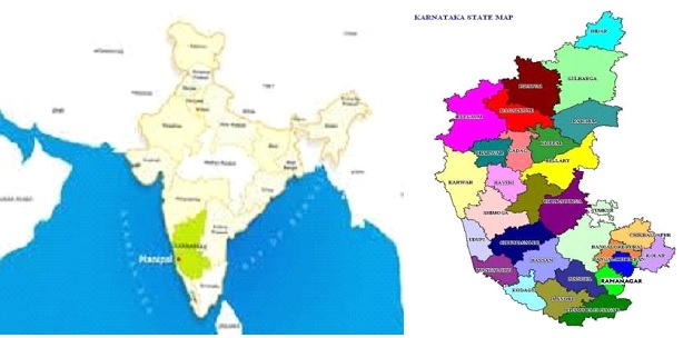
Figure: River basins –
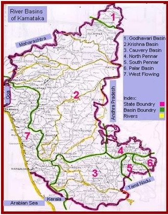
1: Godavari, 2: Krishns, 3: Cauvery, 4: North Pennar, 5: South Pennar, 6: Palar, 7: West flowing rivers
There are seven rivers (Figure 1c) in Karnataka
| No. | River System | Drainage Area | |
| 1000 Sq. km | % | ||
| East Flowing Rivers | |||
| 1. | Godavari | 4.41 | 2.31 |
| 2. | Krishna | 113.29 | 59.48 |
| 3. | Cauvery | 34.27 | 17.99 |
| 4. | North Pennar | 6.94 | 3.64 |
| 5. | South Pennar | 4.37 | 2.29 |
| 6. | Palar | 2.97 | 1.56 |
| 7. | West Flowing Rivers | 24.25 | 12.73 |
| Total | 190.50 | 100 | |
| Rivers | Drainage area | |
| 1000 sq.km. | % | |
| East Flowing rivers (1 to 6) | 166.25 | 12.73 |
| West Flowing rivers | 24.25 | 87.27 |
| Total | 190.5 |
A report by Dr. T.V. Ramachandra, Vinay S and Bharath H. Aithal
Notes:-
- This report was commissioned for India Rivers Week 2016.
- The Karnataka Drainage map has been put together by a WWF Team led by G Areendran, the names of the rivers have been provided by an INTACH Team led by Dr. Manu Bhatnagar.
- The names in bracket represent the Key tributaries; RED color is for (Critical) status; BLUE is for (Safe) status and rest are PINK (Threatened) status.
- Its a short description, for detail report kindly explore the link Karnataka Rivers Profile
- You may also like to see rivers profiles for Rajasthan, West Bengal, North-East India, Maharashtra , Haryana, Uttarakhand , Himachal Pradesh, Kerala States
- The same report can also be seen on India Rivers Week Blog

I like most of the posts here. This time I felt things wanting. A thorough critical analysis of state of Rivers of Karnataka is expected.
LikeLike
I agree, Rajendra ji. But this is what we could get at the moment. Are you in a position to suggest or provide a more thorough critical analysis? Plz let me know. You can write to me on my email ht.sandrp@gmail.come if that is ok with you.
LikeLike
sir plz give the information about gravity diversion of tunga river water and send to my mail avinashkakhandki@gmail.com
LikeLike
Thanks, Avinash, let us know what exactly are you looking for and if we have that information or can locate it, will get back.
LikeLike
Sir, Congrats for excellent detailed presentation of rivers in Karnataka state. For the past few years due to global environmental changes precedent rain is coming and damaging lives of the river bank people.
My idea is if Krishna river water is linked to drought prone districts like kolar, chikkaballapur, Gulbarga etc., through underground pipes and linking to the lakes in these districts tje excess water can be sent to these districts during mansoon or such floods. This helps the water table level in these districts as well as generates huge agri activities and employment to many un skilled also.
LikeLike
Sir, thanks.
About your suggestion, we are not even harvesting rain that falls in the Northern Karnataka areas. We need to do that first and also avoid unjustified water intensive activities like sugarcane and paddy cultivation. We do not think there is much merit in interlinking of rivers.
LikeLike