
The river Godavari is the largest of the peninsular rivers of India. Maharashtra is home for its early flows and Godavari for Maharashtra is no less than Ganga. Referred to as Dakshin Ganga the river holds immense spiritual and cultural significance. Several places at its origin are said to be abode of Rama during the exile. These places are worshipped even today.
One of the unique aspects of this river is that it drains nearly entire East to West length of Maharashtra. And while running ceaselessly towards the Bay of Bengal the river encompasses nearly all the geographically diverse regions of the state. Originating in Western Ghats this river later traverses through the arid and dry region of Marathwada and then emerges in high rainfall region of Vidarbha. While the Upper Godavari sub basin is a part of prosperous sugar cane growing belt of Western Maharashtra; its tributaries like Manjara and Wardha-Wainganga flow through the region where there is still significant potential of local water systems.
The river is indeed a lifeline of the state and has been nourishing its culture and traditions for centuries. SANDRP attempts to present Maharashtra state specific profile of this river.
Salient Features

Godavari rises at an elevation of 1,067 m in the Western Ghats near Thriambak Hills in the Nashik district of Maharashtra. After flowing for about 1,465 km., generally in south-east direction, it falls into the Bay of Bengal.
The Godavari is the biggest of the east-flowing rivers of the peninsular India and the second largest river draining in India. Godavari basin drains about 9.5% of India’s total geographical area. The catchment area of the basin is 3,12,812 sq km extending over the states of Maharashtra (48.6%), Telangana (20% approx.), Madhya Pradesh (10.0%), Andhra Pradesh (3.4% approx.), Chhattisgarh (10.9%), Odisha (5.7%) & Karnataka (1.4%).
Basin Boundaries: The Godavari basin falls in Deccan plateau. Around 32% of Godavari basin area lies in the elevation zone of 500-750 m. The basin is bounded on the north by the Mahadeo Hills, the Satmala Hills comprising a series of table lands varying from 600-1200 m in elevation. The western edge of the basin is formed by an almost unbroken line of the North Sahyadri range of the Western Ghats, from 600-2100 m height. The eastern area of the basin is majorly covered by the Dandakaranya Range with the Eastern Ghats rising from the plains of East Godavari and Vishakhapatnam. Eastern Ghats are not as prominent as Western Ghats. The southern boundary of the basin follows the Harishchandra Range in west, Balaghat Range in the center and the Telangana Plateau in east.
Basin is broadly divided into Maharashtra Plateau, Vidarbha Plains & Dandakaranya Region. Except for the hills forming the watershed around the basin, the entire drainage basin of the river Godavari comprises of undulating country, a series of ridges and valleys interspersed with low hill ranges. Large flat areas which are characteristic of the Indo-Gangetic plains are scarce except in the delta.
Principle Tributaries: The Pravara, the Manjra are the main tributaries joining on the right bank of the river and the Purna, the Pranhita, the Indravati, the Sabari are the main tributaries joining on the left bank. The Pravara rises in the Western Ghats flowing in an easterly direction falls into the Godavari with its drainage area falling entirely in Maharashtra.
The Purna rises in the Ajanta Range of hills flowing in a south-easterly direction joins the Godavari. Of its tributaries, the longest is the Dudna. The chief tributaries of the Purna on the south bank are the Pendhi, Uma, Katepurna, Nirguna and Man.
The Manjra rises in the Balaghat Range of hills flowing in a general east-south-east direction. The principal tributaries of the Manjra are the Tirna, the Karanga and the Haldi joining it from right and the Lendi and the Maner which join from the left.
The Pranhita is the largest tributary of the Godavari. It conveys the combined waters of the Penganga, the Wardha and the Wainganga and below its confluence with the Manjira it falls into Godavari.
The Indravati rises on the western slopes of Eastern Ghats in the Kalahandi district, flows through the central part of the Dankaranya region, with its catchment in Madhya Pradesh and Odisha rises at an altitude of 915 m, joins the river Godavari. Its important tributaries are the Narangi, the Boardhig, the Kotari, the Nibra and the Bandia on the right and the Nandiraj and the Dantewara on the left.
The Kolab rises at an altitude of 1372 m in the Sinkaram hill ranges of the Eastern Ghats, drains the southern uplands of the Dandakaranya region. The Machkund or Sileru, a major tributory of the Sabari rises at an altitude of 1220 m joins above the confluence of Kolab and Godavari. The Kanger and Malengar are the two other important tributaries of the Sabari.
Table below summarises lengths and catchment of major tributaries
| Length of River & its major tributaries (Source: Krishna Basin Profile by CWC) | |||
| S.No | Name of River | Length (km) | Catchment Area (sq km) |
| 1 | Godavari | 1465 | 312812 |
| 2 | Upper Godavari (Source to Confluence) | 675 | 33502 |
| 3 | Pravara | 208 | 6537 |
| 4 | Purna | 373 | 15579 |
| 5 | Manjira | 724 | 30844 |
| 6 | Middle Godavari (Between confluence of Manjira and Pranahita) | 328 | 17205 |
| 7 | Maner | 225 | 13106 |
| 8 | Penganga | 676 | 23898 |
| 9 | Wardha | 483 | 24087 |
| 10 | Wainganga | 580 | 49695 |
| 11 | Pranhita | 721 | 61093 |
| 12 | Lower Godavari (Pranhita Confluence to Sea) | 462 | 24869 |
| 13 | Indravati | 535 | 41655 |
| 14 | Sabari | 418 | 20427 |
Rainfall
Basin receives 85% of its annual rainfall during south-west monsoon. The rainfall, fairly heavy though irregular and unevenly distributed varies temporally and spatially across the basin. South-west monsoon sets in by July and ends by September entering through the west and south-west coast meets the Sahyadri Range sweeps across the interior of the peninsula. Upper reaches of Godavari Basin lie in the 25 Km wide crest zone of Sahyadri which is the belt of heaviest rainfall region in Maharashtra. Annual rainfall varies from 1000 to 3000 mm in this reach. River further enters in the region falling in the rain shadow area of the Sahyadri which receives less than 600 mm annual rainfall. Rainfall gradually increases to about 900 mm towards the East coast that changes the landscape and the cropping pattern in the eastern Maharashtra, the Wardha-Wainganga sub-basins. Annual rainfall varies from 755 mm to 1531 mm and the average annual rainfall in the basin is 1096.92 mm.
Cultural Aspects
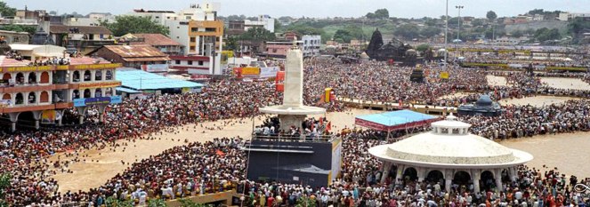
The river is considered no less than a sister to Ganga and I remember as a child, elders always referring to Godavari as Ganga. Even in Feb 2017, when I visited Nashik, Uttara Deshpande ji (Mother of my SANDRP colleague Parineeta Dandekar) repeatedly referred to Godavari as Ganga. Nashik is important religiously not only as the birth place of this DakshinVahini Ganga, where she refused to fall into the Arabian Sea, but also because of the deep association of the city with Ramayana. Nashik was believed to be a part of Dandakaranya where Lord Ram resided for nearly 14 years in Vanavasa. All along the river in places like Tapovan, one can find glimpses of this ancient myth worshipped today. On the banks of Godavari in Nashik also stands the Kala Ram Mandir where, in 1930, Babasaheb Ambedkar launched the Kala Ram Mandir Entry Satyagraha, storming the temple which was thus far restricted for the depressed classes. Indeed, Godavari has borne witness to several remarkable happenings at her origin itself. In her middle reaches in Nanded, Takth Sri Hazur Sahib graces the banks of the river where Guru Gobind Singh breathed his last. The place is one of the five holy places in Sikkhism.
Principle Sub-Basins
Manjra: Manjra is a 724 kms long tributary of Godavari which originates from the Balaghat ranges of Maharashtra and meets Godavari in Telangana. It is also a unique river which originates in low rainfall region of Balaghat and flows onwards to higher rainfall regions of Telangana before joining Godavari. The principal tributaries of the Manjara River are Tirna, Karanga, Halai, Lendi and Maner. Manjara River flows through Latur District of Maharashtra and Bidar District of Karnataka before entering Medak District in Telangana. It flows for about 96 km in Medak District and ultimately drains into Godavari River at Basara near Nizamabad. The catchment area of the Manjra River including its tributaries is 30,844 km2 lying in a zone which gets about 635 mm of rain annually.
A large portion of Maharashtra (Marathwada) falling in Manjara basin is drought prone. It is the rain shadow area of the Sahyadri (Western Ghats) which receives less than 600 mm annual rainfall. The region was one of the worst drought-affected regions of India during 2012-15. All the major dams including Manjara, Majalgaon, Lower Terna, Manar, Siddheshwar and Sina-Kolegaon dried up in 2015. The state government had roped in a train to provide drinking water to Latur city, all the way from Miraj, about 342 km away.
Union Government recently announced that it plans interlinking of Bhima and Manjara rivers to tackle the drought of Marathwada.[i] The two rivers will be linked through Ujani dam on Bhima river and Manjara Dam on Manjara river. Water experts are already raising alarms over this proposition. Manjara flows from Latur district while Bhima originates in Pune and flows to Solapur. Latur is 636 metres above mean sea level while Bhima is situated about 500 metres above mean sea level. This means that the water will have to be lifted to a height of about 150 meters. Locals are of opinion that the Ministry seems to have announced the project without studying the terrain, feasibility and ignoring the past experience of lifting water at a height which had not been successful. A decade ago a project was implemented to lift Terna dam water to a height of 150 meters for Osmanabad. But the project came to a halt soon without benefitting any land.
Wainganga: Wainganga is one of the principle tributaries of Godavari River- the largest of the peninsular rivers of India.[ii] The Wainganga River originates in Mundhara village in Dist. Seoni of Madhya Pradesh, which lies at the foothills of Satpuda Mountains[iii] and traverses a length of total 635.40 km till its confluence with Wardha River at Shivni Village in Chandrapur District of Maharashtra to form River Pranahita which is one of the biggest tributaries of Godavari.[iv]

Vidarbha Region of Maharashtra through which Wainganga flows harbors unique geological landscape. This is the region where basalt, so typical of Maharashtra plateau, comes in contact with the older crystalline rocks giving rise to granite-gneissic relief.[v] Along with this several other rocks such as Deccan trap, laterite, granite, sandstone, shale, dolomite, mica, schist etc. contribute to the varied rock formation of the region.[vi] This change in the geological configuration with a concurrent increase in rainfall up to more than 1500mm on the rugged hilly land has changed the nature of soils and promoted a more luxuriant growth of vegetation in Vidarbha.[vii] The five districts of Maharashtra state which form southern two third portion of the Wainganga Valley viz Nagpur, Bhandara, Gondia, parts of Chandrapur and Gadchiroli are the largest forested areas of the state accounting for more than half (55.5%) of the total state forest area.[viii] Four out of total six tiger reserves of Maharashtra lie in these five districts. 30% of the total tribal population of the state stays in these five districts.[ix] Vidarbha region has historically been economically backward region of Maharashtra.
Biodiversity of the basin
Godavari basin supports significant forest are in the Central India much of this is in the belt of eastern Maharashtra, Chhattisgarh and Telangana states. Wainganga, one of the most important tributary of the Godavari is the stage of Kipling’s Jungle Book. Wainganga River Basin is home to two oldest tiger reserves viz. Tadoba Andhari National Park in Maharashtra and Pench National Park in Madhya Pradesh[x] and several other wildlife parks which harbor presence of flagship species such as Royal Bengal Tiger & elephant[xi] along with various other species of endangered fauna. The basin is virtually a nexus for critically important tiger corridors of Kanha, Pench, Satpuda, Melghat, Navegaon-Nagzira, Bor and Tadoba tiger reserves. It provides for 16,000 sq km of undisturbed landscape connecting Kanha and Pench tiger reserves which according to National Tiger Conservation Authority (NTCA) and Wildlife Institute of India (WII) is one of the four most viable tiger habitats in the country.[xii]
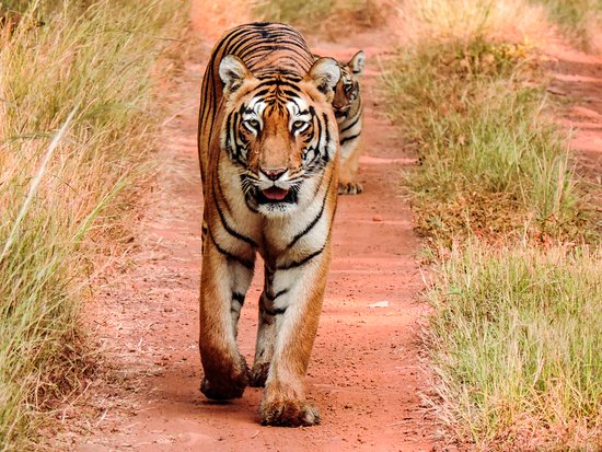
Table below lists these areas-
| Wildlife sanctuaries/ Protected areas/ National Parks in the basin: | |||
| Sr. No. | State | Wildlife sanctuaries/ Protected areas/ National Parks | District |
| 1. | Maharashtra | Tadoba National Park (Tiger Reserve) | Chandrapur |
| Bor Wildlife Sactuary | Wardha | ||
| Navegaon Wildlife Sanctuary | Gondiya | ||
| Nagzira Wildlife Sanctuary | Gondiya | ||
| Pench National Park (Tiger Reserve) | Seoni | ||
Dams & Barrages
Dams are a primary challenge faced by a river due to the profound ways in which they affect the hydrology, ecology, sociology, continuum of the river. The number of dams constructed in Godavari basin is the highest among all the river basins in India.
According to MoWR (Ministry of Water Resources), so far nearly 921 Dams, 28 Barrages, 18 Weirs, 1 Anicut, 62 Lifts and 16 Powerhouses have been constructed in Godavari basin for irrigation, diversion or, storage purpose. The basin has 70 Major Irrigation Projects and 216 Minor Irrigation Projects.

Gangapur Dam: Godavari has been dammed right after its origin in Tryambakeshwar. This dam has seen one of the biggest diversions of irrigation water for non-irrigation purpose. Nashik city which is situated immediately downstream of the dam has been claiming more and more water from the dam. Drought of 2016 which was one of the worst droughts was followed by highest-ever drinking water reservation for the city from Gangapur dam complex. NMC had demanded 4.2 TMC from Gangapur dam, against which it could secure 3.9 TMC. This growing claim has been at the cost of water that needs to flow to Jayakwadi dam to cater to drinking water and irrigation needs of Marathwada.
Jayakwadi project boasts of the one of the longest dam walls in the country, running more than 10 kms, which has resulted in massive evaporation losses from the reservoir. The project was built displacing 70 villages and is now in the eye of the storm as intra state water disputes heat up in Maharashtra. In the upstream of Jayakawadi are more than 11 large dams in the districts of Nashik and Ahmednagar, which is a cane and grape growing region. Downstream Jayakawadi too are several projects on the Godavari and tributaries in Maharashtra like 11 barrages on Godavari, Vishnupuri, Upper Penganga, etc.
Dams in Marathwada: The large dams in Marathwada made headlines throughout the drought of 2016. Many of them built in the water deficit basin of Manjara River were hardly any rescue for the parched region. Along with Jayakwadi dams such as Majalgaon, Manjara, Yeldari, Siddheshwar Vishnupuri, Lower Terna, Manar, and Sina-Kolegaon supplying water to Aurangabad, Hingoli, Nanded, Latur, Parbhani, Beed have dried up completely.[xiii] The lower Dudhana and Upper Painganga were the two large projects in the parched region to have marginal water supply on which few of these towns survived.[xiv]

Gosikhurd: The massive GosiKhurd Dam built on Wainganga River, one of the biggest tributary of Godavari, is mired in corruption charges. The project has been languishing incomplete for last more than 32 years and is facing an ACB probe. The construction of canal network including the Right Bank Main Canal (RBC) is still 50% incomplete. Stalled in 2009 the construction of RBC is yet to resume.
Other dams on Wainganga: Wainganga Basin is a region of critical importance for Maharashtra to preserve its forests, wildlife, and tribal population dependent on it. Having complete disregard for the rich ecosystem of the region Vidarbha Irrigation Development Corporation (VIDC) which was established by state’s Water Resources Department (WRD) has been pushing unfeasible dam projects. A whopping 257 number of projects taken up by VIDC were ongoing in Vidarbha (in Wainganga and Wardha sub basins of Godavari) as on March 2011.[xv] Ironically these projects are laden with several procedural & financial irregularities like ad hoc planning & feasibility studies, poor execution of projects, almost no rehabilitation of project-affected persons, financial irregularities, huge unjustified cost overruns, defective execution of projects, lack of distributaries, lack of requisite environmental and forests clearances etc.[xvi] Dams like Bembla, Upper Wardha, Arunavati have been in limelight for the poor quality of construction, corruption and violations.
Details of some of the important dams are annexed at the end.
Intra state water disputes[xvii]
Intra-state water conflicts in Maharashtra are unfortunately becoming a routine. Maharashtra has been trying to address the recurrent conflicts though some of its institutional mechanisms like the Maharashtra Water Resources Regulatory Authority (MWRRA). MWRRA itself is riddled with several serious flaws, but for now is supposed to function as an appellate authority in adjudicating water releases from upstream projects to the downstream in times of scarcity. However, MWRRA has been defunct for long now.

Godavari basin has been the stage of such conflicts consistently for past few years. This conflict is concentrated around Jayakwadi Dam in Aurangabad, which is the gateway of Marathwada. In 2015 the decision of Godavari Marathwada Irrigation Development Corporation (GMIDC) to release 12.85 TMC (Thousand Million Cubic Feet) of water from upstream dams in Nashik and Nagar District in October for Jayakwadi dam which had barely 5% of its live storage then based on an order issued by MWRRA in September 2014 was met with dissatisfaction, uproar and sharp protests from the upstream (because any release of water from upstream dams is seen as their loss) as well as the downstream (because they think water released is too meager compared to rightful share of downstream area dams).
The decision came only after a long drawn petition filed by parties like Marathwada Janata Vikas Parishad and Aurangbad-based MLA (Member of Legislative Assembly) in Bombay HC for releasing water from upstream dam to Jayakwadi. MWRRA which was dysfunctional till 2013 came in the ring only after several orders of the High Court, facilitating mode and purpose of water release. MWRRA’s decision to release water was again challenged in HC and SC and was upheld by both the courts.
The water release was pushed due to huge resentment and protests in Marathwada. As was expected, this was strongly contested by upstream regions of basin Nagar and Nashik largely fueled by politicians, sugar industries. Marches, protest meetings were organised in these cities. Farmers protested at Dams like Gangapur.
Intra State River Linking
Godavari basin is also a major focus of intra-state river link proposals in Maharashtra. Apart from Bhima-Manjara link announced recently, of the total 20 links proposed originally by the GoM 8 links involve Godavari Basin. Status of these linking proposals is as follows.[xviii]
| Sr. No. | Name of the Intra-State Link | Rivers | Status of DPR |
| 1 | Wainganga (Gosikhurd) – Nalganga (Purna Tapi) | Wainganga & Nalganga | Completed |
| 2 | Wainganga – Manjara Valley | Wainganga & Manjara | Completed, not found feasible |
| 3 | Upper Ghat – Godavari Valley (Damanganga (Ekdare) – Godavari Valley) | Damanganga & Godavari | Completed |
| 4 | Upper Waitarna – Godavari Valley | Waitarna & Godavari | Completed |
| 5 | North Konkan – Godavari Valley | Patalganga & Godavari | Completed |
| 6 | Sriramsagar Project-Purna-Manjira | Godavari, Purna & Manjira | Completed |
| 7 | Wainganga (Gosikhurd) – Godavari (SRSP) | Wainganga & Godavari | Withdrawn by Gov of Maharashtra |
| 8 | Jigaon – Tapi – Godavari Valley | Tapi & Godavari | Completed |
Pact between Telangana and Maharashtra over waters of Godavari
In August 2016 Maharashtra & Telangana governments signed pact for three irrigation projects to be constructed on River Godavari. Under the agreement, the two states would take up Tummidihatti, Medigadda (Kaleswaram) and Chanaka–Korata projects. Chief Minister of Telangana K Chandrasekhar Rao reportedly said that “this would herald a new era in the relations between the two states and would be a standing example of how the states can resolve inter-state disputes without the Centre’s intervention.”[xix]
This pact which has been looked at as ‘historical victory’ for Telangana for convincing the neighbouring states is in fact in violation of our country’s environmental law framework. Tummidihetti Project & Medigadda Project featured in the agreement have long history of gross irregularities and violations exposed by several apex agencies as well as media.
Tummidihetti Project is in fact an altered version of much controversial “Dr. B.R Ambedkar Pranahitha Chevella Sujala Sravanthi Project” popularly known as ‘Pranahita chevella project’. This project originally planned to divert 160 TMC water from river Pranahita (a major tributary of Godavari River) by constructing a barrage at TummidiHetti village in Adilabad District of Telangana has already been under construction illegally for last more than two years.[xx] Construction of the canals for Pranahita Chevella project was started hastily without obtaining Environment Clearance (EC), forest clearance (FC), wildlife clearance (WC), without sorting out interstate aspects or without even finalizing the height of the dam or assessing any feasibility or taking the local people into confidence.
Medigadda barrage is a part of Kaleswaram LIS comprising of three barrages to come up at Medigadda, Annaram and Sundilla. The Medigadda barrage is being proposed with a 100-metre FRL to store 16.17 TMC of water, the Annaram with 120-metre FRL to store 3.52 TMC and Sundilla barrage with 130-metre FRL to store 1.62 TMC of water.[xxi]
Government of Telangana has taken up six other projects in the region along with the three projects forming a part of the pact including Lower Penganga & Lendi. Construction of total 10 dams & barrages is involved. (list given at the end)
List of projects taken up by Telangana around Pranahita Chevella Project (Source: Pre-Feasibility Report of Chanaka Korata Project)
| Name of the project | River basin | Status | (District) | Storage (TMC) |
| ChanakaKorata (Rudha) | Penganga | Proposed | Yavatmal (Mah) | 1.5 |
| Rajapeth | Future | Not finalised | 0.7 | |
| Pimprad | Future | 1.5 | ||
| Lower Penganga | Penganga | Future | Yavatmal (Mah) | 5.12 |
| Mahadivagu | Ongoing | Adilabad (Tel) | 0.905 | |
| Satnala | Existing | 2.048 | ||
| Pranahita | Pranahita | Ongoing | Chandrapur (Mah) | 160 |
| Medigadda | Godavari | Future | Karimnagar (Tel) | 26.77 |
| Annaram | Future | 2.27 | ||
| Sandilla | Future | 1.08 |
Water Quality and Pollution:
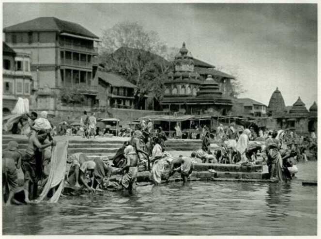
Like all rivers across India, Godavari too faces severe pollution from urban and rural sewage, agricultural runoff, and industrial effluents. In Maharashtra a whopping 300 km upper stretch of Godavari from Nashik District to Paithan has been declared as priority I critically polluted stretch by CPCB with BOD ranging from 6 mg/l to 36 mg/l[ii]. A petition has been filed in the high court by few activists from the city against Nashik Municipal Corporation (NMC), Government of India (GoI), Government of Maharashtra (GoM), and Maharashtra Industrial Development Corporation (MIDC) for failure on their part to clean the river[iii].
Large stretches of major tributaries of Godavari are also critically polluted e.g. 150 km stretch of Wainganga from Tumsa to Ashti has been declared as critically polluted. Another 150 from Penganga river has also been critically polluted. 20 km stretch of Kanhan, 40 km stretch of Darna, 2 km stretch of Manjara among few others feature prominently through the CPCB report. Domestic sewage of urban centres is one of the principle pollutants of Godavari. However in Wardha basin the river is also critically polluted due to coal mining and thermal power plants. Mud from the coal mines and ash from the thermal power plants is routinely disposed in the river in this region.
Summing up

From the origin in Western Ghats to its exit at the Eastern boundary of the state, Godavari traverses a major part of Maharashtra and nourishes several rich cultures and social milieus: from Marathi in Deccan plateau to ancient tribal culture in central India. The River is fettered in many dams all along its length and across its basin which have been responsible for human sufferings, ecological impacts, livelihood struggles and conflicts. Shades of the conflicts around the dams differs according to the regions. E.g. while the dams in Marathwada are facing extreme water scarcity the dams in Vidarbha are being constructed without giving due regard to the rich ecology of the region or to the people and impacts or laws of the land. Underlying common thread however seems to be the growing claims on the river.
The basin is facing several major issues, but the river is also resilient. Let us hope that inhabitants of the Godavari basin are empowered and awakened to solve the problems of their river.
ANNEXURE
| Important dams in Godavari Basin (Source: Godavari Basin Profile by Central Water Commission) | ||||||
| Sr. No. | Name of dam | River/
Tributary |
Name of the project | Location | Capacity
MCM |
Completion |
| 1 | Gangapur Dam | Godavari | Gangapur Major | Nashik Dist Mah | 215.88 | 1965 |
| 2 | Darna Dam | Darna | Godavari (Darna) | Nashik Dist Mah | 215.9 | 1916 |
| 3 | Karanjwan dam | Kadwa | Upper Godavari | Nashik Dist Mah | 175.6 | 1974 |
| 4 | Bhandardara | Pravara | Pravara | Ahmadnagar Mah | 312.6 | 1926 |
| 5 | Totladoh Dam | Pench | Pench Irrigation Project | Nagpur Dist Maharashtra | 1241 | 1989 |
| 6 | Kamtikhairi | |||||
| 7 | Jaikwadi Dam | Godavari | Jaikwadi Stage-I, II | Aurangabad Mah | 2909.04 | 1976 |
| 8 | Yeldari Dam | Purna | Purna | Parbhani Mah | 934.3 | 1958 |
| 9 | Siddheshwar | Manjra | Singur | Hingoli Dist Mah | 250.85 | 1968 |
| 14 | Gosikhurd Dam | Wainganga | Gosikhurd | Bhandara Mah | 1146.07 | – |
| 15 | Isapur Dam | Penganga | Upper Penganga | Washim Dist Mah | 1.79 | 1979 |
| 16 | Upper Wardha | Wardha | Upper Wardha | Amravati Mah | 802.98 | 1993 |
Authored by Amruta Pradhan (amrutapradhan@gmail.com) SANDRP
END NOTES:
[i] http://indianexpress.com/article/india/india-news-india/latur-gears-up-to-recharge-10000-borewells-2784964/
[ii]MoWR (2014): “Godavari Basin”, March 2014, Ministry of Water Resources, p.1
http://www.india-wris.nrsc.gov.in/Publications/BasinReports/Godavari%20Basin.pdf, accessed on September 29, 2015
[iii] ibid., p. 16
[iv]Planning Commission (Undated): “Report of the Working Group on Ecosystem Resilience, Biodiversity and Sustainable Livelihoods for the XII Five-Year Plan”, Planning Commission – Environment & Forest Division Steering Committee – Environment, Forests & Wildlife and Animal Welfare, p.118
http://atree.org/sites/default/files/Ecosystem%20Resilience%20Biodiversity%20and%20Sustainable%20Livelihood%20Final%20Draft%20Version%200.pdf accessed on October 3, 2015
[v]MoWR (2014) “Godavari Basin”, op., cit., p. 7
[vi] IIT Delhi (2012): “Impact of Water Resources Projects – Case Study Of Wainganga”, (Study Sponsored by Greenpeace), April 2012, p. 1
http://www.greenpeace.org/india/Global/india/report/technical-report-Wainganga-1.pdf, accessed on September 21, 2015
[vii]MoWR (2014) “Godavari Basin”, op., cit., p. 7
[viii] Ibid.
[ix]Calculated based on District Socio Economic Review of five basin districts published by Directorate of Economics and Statistics, Planning Department, Government of Maharashtra
https://mahades.maharashtra.gov.in/publication.do?pubCatId=DSA accessed on December 3, 2015
[x]MoWR (2014) “Godavari Basin”, op., cit., p. 168
[xi] Planning Commission (Undated): “Report of the Working Group, op., cit., p.118
[xii] Jay Mazoomdaar (2010): “Surrendering the Last Frontier”, OpenMagazine, Issue dated 23 January 2010
http://www.openthemagazine.com/article/nation/surrendering-the-last-frontier accessed on September 23, 2015
[xiii] http://www.hindustantimes.com/mumbai/state-s-major-dams-dry-up-but-pre-monsoon-rain-brings-hope/story-p4y33QTYTwVqTnSEg6r3kN.html
http://indiatoday.intoday.in/education/story/water-crisis-in-marathwada/1/635597.html
[xiv] Ibid.
[xv]CAG (2014): “Report of the Comptroller and Auditor General of India on Management of Irrigation Projects”, Government of Maharashtra, Report No.3 of 2014, tabled before State Legislature Assembly on June 14, 2014
http://agmaha.nic.in/Audit%20Reports/Pr_Aud_mum/2013-14/3of2014.pdf , accessed on October 06, 2015, p.44
[xvi] CAG (2011): “Report on the audit of expenditure incurred by the Government of Maharashtra” prepared by Comptroller and Auditor General of India
http://www.indiaenvironmentportal.org.in/files/file/maharashtra%20audit%20report.pdf , accessed on October 06, 2015
[xvii] https://sandrp.wordpress.com/2015/11/26/hydro-hegemony-dams-and-equitable-water-distribution-learnings-from-maharashtra/
[xviii] http://www.nwda.gov.in/writereaddata/mainlinkfile/File409.pdf
[xix] The Hans India (2016): “Historic water pact with Maharashtra on Aug 23”, The Hans India, August 21, 2016
[xx] As stated in documents obtained by SANDRP from Chandrapur Irrigation Division of Maharashtra
[xxi] Indian Express (2015): “Main Barrage on Pranahita at Medigadda, Says Government Advisor”, Op.Cit.

It was brief and informative. It would be appreciable if Maharashtra’s entitlement of Godavari waters are quantified as per GWDT. Hope this information would be added.
LikeLike