

Dr Dinesh Kumar Mishra (dkmishra108@gmail.com)
Read the article by Thakkar and Dandekar[1] on sediments with great interest. The basic duty assigned by nature to any river is to build land (nearest word is delta formation), transport the water falling on its catchment to the master drain or the sea and keep the ground water level intact besides saving its fertility. Scriptures define river in many other ways. The basic reason for that was, probably, to discourage tempering with the river. The rivers flow for the good of all the living beings (paropakaray bahanti nadyah), they are cited as an example for continuity. Our ancestors used to bless the younger ones that their name and fame will last till the rule of forests, mountains and rivers are there. There are strict restrictions about polluting rivers and the punishment is also prescribed for doing so. That provides enough food for thought about rivers to us. When we recall our rivers to grace any religious or social ceremony, the emphasis is never forgotten as to what should be our attitude towards rivers. Most of our festivals are held on the bank of the rivers (barring Karmanasa) in Bihar which is called tirthas i.e, the sacred places.
We care too hoots about our rivers now.
An engineer or a trader looks at the rivers about the profits that can be made by the existence of the rivers and they rightly use the word ‘exploitation’ which we all know what it means. As engineers, we all are trained to look into the Benefit Cost ratio and are never taught about the social costs. That is not our job. We tell the politicians where the profit and votes lie. They, in turn, tell all others that they have a team of world class engineers who have advised this or that. The implementers (the contractors) intervene in the mean while. Then there may be financers, promoters, consultants and what not, each with some vested interest or the other. Some of them are for money, some for power, some for name and fame and some for merely impressing others of their proximity with the sources of power.
Each one of them has an insurance that by the time the ill effects of their wrong doing come to the fore, they will not be there in this world. That sets the tone for discussions now.
Let us look at the physical characteristics of river water. The river water contains sediments of all kinds and their shape and size depends on the locations that they are transported to by the river water. The ultimate destination, however, is the sea. I have read considerable literature about sediments and floods and I know that at least since middle of the 19th Century, the British engineers in India have been telling that water is not the problem and it is the sediment that is responsible for flooding. This should be treated first if the floods are to be avoided.
Unfortunately, we are not taught how to deal with sediments and we read about it as a passing reference. Water flows downstream but the sediments remain where the water no more is in a position to push it further down.
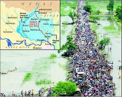
Structurally, if you intercept water by a dam, the sediment will collect in the reservoir area. I had read a report of Central Water Commission a few years ago (I should be having a copy of it somewhere in my collection) wherein they had studied the sedimentation of 64 reservoirs in India but only in two of them their prediction of sedimentation was near to reality. Rest all the dams were in pathetic situation. Trap the river within embankments, the sediment will settle within the embankments and raise the bed level of the river. Kosi is a good example of mishandling of sediments. This river was flowing in 15 different channels some 60 years ago. The engineers embanked just one of these channels and forced all the water and sediments into that channel. The result is that the bed of this channel is higher than the adjoining ground. In lower reaches, the river is aggrading at a rate 12.03 centimeters every year. The engineers and the State is busy raising the embankments without realizing that they are ‘storing disasters for the future generation.’ Construct a ring bundh round a settlement to protect it from the floods of river, the sediment will settle outside the ring to the detriment of the community in future.
Many settlements in Bihar were encircled by such rings in the past. These are all a false security for the people. There is sand casting within the protected area and boats ply there during the rainy season. Some of these rings do not exist anymore because the river has wiped them out. Every step of mishandling sediments leads to a disaster situation which we do not know how to cope with and do away with the sediment.
Look at any silt laden river. It used to spread the sediments free of cost all over the area which is what we call the land building by a river. You disturb a river and this quality is lost.
Then starts the famous debate on forests. The engineers are again confused over the issue and they are not sure whether restoration of the forests can be of any use. Once the ground is saturated due to rains, the role of forests is over, they say. Fortunately such conclusions are not available freely in vernacular. I shudder to think how the masses will react to such wisdom.
I had a chance meeting with the Minister of Water Resources of Bihar before this election and he wanted me to suggest something to combat floods. The discussion boiled down to sediments and the quantity of sediments that passes through Bihar every year.
Irrigation Commission Report of Bihar (1994) talks vaguely about sediments and no inference can be drawn out of it. This may be willful that a reader may not decode the information contained in the report.
Now, if it is understood that sediments are the problem, do we know the amount of it? The answer in ‘No’.
Or, even if it is available, it is not in public domain. We keep on telling that rivers have become shallow but its extent is not known in most cases. I suggested to him that if the government was really serious about the issue, let us take cross section of the river at strategic points that the WRD must have been taking before independence or after the establishment of the Planning Commission and check what is the extent of aggradation of the river bed and what have been the change in the cross section. This will tell us the sediment retained in the river bed and give a hint about its transportation to the sea. It will also tell us that if we pursue the policy of flood control as we are doing at the moment, what will be the fate of the river after say 50 years. He very kindly phoned his principal secretary who, probably, told him that this was possible.
Two questions arise from this discussion, (i) does it require an outsider like me with little access to information that these august bodies dealing with rivers have to tell the minister what should be done to assess the sediments? And (ii) what on earth the responsible engineers of the WRD have been doing all these years? Do they know their job and responsibility well?
Former chief minister of Bihar had announced in May 2009 after the breach at Kusaha on the Kosi (in Aug 2008) was plugged that the embankment is not going to breach for thirty years, at least. Everybody interested in the Kosi issue knows that the breach had occurred because the river was pushed towards eastern embankment of the river by sediment deposition on the west and this was not given the attention it deserved.
I wonder since when the rivers have started taking command from the chief ministers. Even if they do, what will happen in thirty first year?
I am of the opinion that a peon in government is more powerful than a Noble Laureate outside for the peon can get something done through his contacts but the latter can only make a request. It is up to the establishment whether it heeds to his/ her advice or not.
3rd July 2014. Jamshedpur
END NOTES:
[1] https://sandrp.wordpress.com/2014/07/03/what-do-rivers-have-to-do-with-silt/
