The claim of THDC, CWC and Uttarakhand Chief Minister that in absence of Tehri dam, Rishikesh and Haridwar would have been washed away is completely baseless and unfounded, nothing but a hype. Facts show that if Tehri Dam id not exist, the water level in downstream towns may have risen on June 16-17, before the levels actually rose on June 18 (as per CWC, peak level in Rishikesh was 340.8 m and in Haridwar at 295.1 m, both on June 18), but are likely to be lower than the levels of June 18 since peak flow in Alaknanda (around 11000 cumecs) was lower than that in Bhagirathi (6900 cumecs). THDC and CWC should refrain from making such claims as they are more like adding salt to the wounds that the people of the state are now experiencing and where dams and hydro projects have played a big role.
From all accounts, it is clear that peak flood in Bhagirathi River on which Tehri dam is situated, occurred on June 16 and the peak flood in Alaknanda occurred on June 17 and not at the same time. So it is not rational to add the two peaks happening at different points of time to claim that Tehri saved downstream areas. If Tehri was not there, there could have been floods in downstream a day earlier, but that does not mean peak level would have been much higher than what was the case with Tehri Dam.
From the records available on the websites of Central Water Commission (http://cwc.gov.in/Reservoir_level.htm) and Central Electricity Authority (http://cea.nic.in/daily_hydro.html), it is clear that water level in Tehri reservoir rose from 749 m on June 15 to 776.8 m on June 18 (water levels for June 16 and 17 are not available for some strange reason), this translated to increase in water storage by 652 Million Cubic meters (MCM). THDC claims that they experienced peak inflow of 244 000 cusecs and moderated that to an outflow of 14000 cusecs. To achieve this moderation for a day would take storage capacity of around 563 MCM, so it is plausible that they achieved this moderation on June 16, when Bhagirathi was experiencing peak flow.
However, as we noted earlier, the peak flow in Alaknanda happened on June 17. THDC should make public hourly figures of flow in Bhagirathi and Alaknanda on June 15-19, outflow from Tehri on each of those hours, level of Ganga at Devprayag, Haridwar and Rishikesh, so that everyone can assess the reality of their claim. Such information should in fact be in public domain in routine way.
It cannot be forgotten that:
Areas downstream of Tehri dam faced avoidable and unprecedented flood disaster in September 2010 (for details see page 20 of Aug Sept 2010 issue of Dams, Rivers & People: https://sandrp.in/drp/DRP_Aug_Sept_2010.pdf). If the dam operation is not done properly, we may be in for a repeat later this season.
It should also be recalled that Tehri is a ticking time bomb in the context of large earthquake that is imminent in the state as seismologists are telling us.( including eminent seismologists like Dr. Vinod Gaur. For more details: Earthquakes and Large Dams in Himalayas)
Landslides and debris flowing into Tehri Reservoir. 2012. Matu Jan Sangathan
People affected by the Tehri dam have still not been rehabilitated, the dam has also not been delivering the peaking power it could, as noted by Central Electricity Regulatory Authority. The dam is also silting up much faster than envisaged, reducing its water holding and power generation capacity.
In fact, CWC has failed in its flood forecasting as we made it clear earlier. Both CWC and THDC need to put their house in order rather making unfounded claims.
Central Water Commission, India’s premier technical body under Union Ministry of Water Resources, has once again failed in the Uttarakhand flood disaster. Even as the Uttarakhand state faced the worst floods in its history, CWC, which has been given the task of forecasting floods across flood prone areas all over India, completely failed in making any forecasts that could have helped the people and administration in Uttarakhand.
First principle of disaster management is prior warning. With prior warning, significant proportion of possible damages and destruction can be avoided. In that respect, one expected that CWC would play a key role in forecasting the floods. SANDRP has been monitoring CWC flood forecasts throughout the monsoon for some years. During June 15-17, when Uttarakhand was receiving the most intense rains, CWC did not make any forecasts regarding Uttarakhand. As far as the most severely disaster affected areas of Ganga basin upstream of Devprayag are concerned (these include the worst affected Kedarnath and Mandakini valley, the Gangotri and Bhagirathi valley and Badrinath in Alaknanda valley), CWC has made no flood forecasts at all this year. Same is the case regarding other affected regions of Uttarakhand including Yamuna basin including Yamunotri and Pithoragarh including Goriganga basin. What is than the role of this premier technical body tasked with flood forecasting?
The only forecast that CWC made for Uttarakhand this June 2013 were for Rishikesh and Haridwar on June 18, 2013. Even in these instances, CWC’s callousness is reflected. For example, by the fact that normally when flood forecasts are made for any site in the first place, the forecasts would be low flood forecast (where water level is between warning and danger level for the site), and only in next stage, would medium flood forecast would be made (water level above danger level). However, in case of both Rishikesh and Haridwar, CWC straightaway made medium flood forecasts, clearly missing the low flood forecasts.
In fact looking at the CWC flood forecasting site (http://www.india-water.com/ffs/index.htm), we notice that in entire Uttarakhand state, CWC has only three flood forecasting sites: Srinagar, Rishikesh and Hridwar, which means CWC would not be doing any forecasts for the most vulnerable regions of Uttarakhand in any case! Even in case of Srinagar (which actually suffered the worst floods with hundreds of damaged houses), CWC site says the Highest flood level is 536.85 m, amazingly, below the warning level of 539 m! This means that CWC has never forecast flood at that site and even if water level goes above HFL, it won’t forecast any floods since level could still be well below the warning level? Can one imagine a more callous technical body?
The callous performance of CWC does not end there. During June 2-7 this year, CWC flood forecasting site as also the flood forecasting site of NDMA which also depends on CWC, stopped functioning. After numerous emails and phone calls from SANDRP, the website started functioning on June 7, 2013 and Shri V D Roy, Director (Flood Forecasting Management) of CWC wrote to us, “Due to technical reasons, the CWC FF site was not working since 2nd June. With consistent effort, the website was made functional w e f 7th June”.
Pointing out a major blunder of CWC, we had written to CWC on June 12, 2013, “CWC forecast site reported that water level of Brahmaputra river at Neamatighat site in Jorhat district in Assam had reached 94.21 m at 0900 hrs (on June 11, 2013), which was 6.84 m above the highest flood level of the site at 87.37 m. The FF site also forecast that the level will be 94.15 m at 0900 am on June 12, 2013, that is today. Both the recording and forecast were clearly wrong, rather way off the mark. The site or the area in question or upstream and down stream levels do not match with what the CWC site said y’day.” Needless to add there was no floods in Brahmaputra in spite of such forecast by India’s highest technical body! CWC is yet to respond to our emails on this issue.
It is strange that CWC, in stead of putting its house in order, is acting as a lobby for big dams by making baseless claims about Tehri dam having saved downstream area of floods, as reported by Indian Express[i] on June 25, 2013. This is like adding salt to the wounds of the people of Uttarakhand who are suffering from the ill effects of lopsided developments including dams and hydropower projects. It would be better if CWC tries to improve its flood forecasts rather than indulging in such lobbying efforts at such times of crisis.
CWC needs to seriously consider including key sites of Uttarakhand into its flood forecasting sites, even if the the duration available for such forecasting is smaller. In times of crisis even a few hours notice can save many lives and also help save other losses.
The India Climate Justice collective notes with deep anguish the devastating loss of life, livelihoods, and homes in Uttarakhand and beyond. The death toll is likely in the thousands, way beyond current official figures. We extend our deep condolences to the families and friends of those killed, and our support to those still fighting for survival, and to local populations whose livelihoods will take years to rebuild.
This tragedy was triggered by extreme unseasonal rains in North India, 2-3 weeks in advance of what is normal for this region. The Director of the Indian Meteorological Department (IMD), Dehradun, said that 340 mm fell in a single day at Doon, a record not seen for five decades. Such extreme and unseasonal rainfall seems to us to indicate a global warming induced climate change phenomenon. Warmer air due to global warming has the capacity to hold more moisture, leading to more intense bursts of rainfall in a particular region. The natural monsoon cycle in India has already been badly disrupted, and a new cycle of extreme rainfall events and prolonged droughts have been reported from all over the country in the recent past. Thus, contrary to statements by senior politicians, the Uttarakhand disaster is not natural: it is no less man-made than the other contributors to the tragedy. And if it is indeed induced by global warming, similar catastrophes could recur with increasing frequency and intensity anywhere in the country in the coming years.
In Uttarakhand, a chaotic process of ‘development’ that goes back many years exacerbated the effects of this extreme rain. Extensive deforestation of mountain tracts, by the state and more recently due to ‘development’ projects, led to soil erosion and water run-off, thus destabilizing mountain slopes and contributing to more intense and frequent landslides and floods. Unchecked hill tourism has resulted in the huge growth of vehicular traffic, spread of roads not suitable to this mountainous terrain, and the construction of poorly designed and unregulated hotels and structures, many near rivers. Sand mining along river banks has intensified water flows into rivers.
Most of all, the construction and planning of hundreds of small, medium and large dams across the Himalayan states from Himachal Pradesh and Uttarakhand in the northern Himalayas to Sikkim and Arunachal Pradesh in the east, have destabilized an already fragile ecosystem and threatened biodiversity. A staggering 680 dams are in various stages of planning, or construction in Uttarakhand alone! These dams have a direct connection with the extent of the damage that can be caused in such flooding events, in that the tunnelling and excavation in the so-called run-of-the-river projects cause huge and unregulated dumping of excavated debris into river basins, leading to increased siltation, and in turn aggravating the flood situation. The electrical power generated by these dams will be consumed by urban elites elsewhere. It is ironic that these dam projects, while adversely impacting people’s access to their river commons, claim to be climate change solutions in the guise of renewable and green energy, and have already made huge profits by fraudulently claiming CDM (clean development mechanism) status. In 2009, the CAG had warned the government of Uttarakhand that the “potential cumulative effect of multiple run-of-the-river projects can turn out to be environmentally damaging”. Like many other warnings by environmentalists and local community groups in the past, this was also ignored. And now we are facing one of the biggest disasters that the country has seen in decades.
The central government of India and various state governments, including the govt of Uttarakhand, have prepared action plans for combating climate change. Any such plan ought to include the establishment of a disaster-prediction and warning mechanism. The Uttarakhand government has taken no measures to prepare for this kind of eventuality, though it has paid lip service to climate action plans over the last three years. In the present case, the IMD issued inadequate warning, which was disregarded by the state government. An urgent prior warning could have ensured that pilgrims don’t move forward and retreat to relative safety, that locals reduce their exposure to risk to the extent possible. Thousands of pilgrims from different states, locals, workers in hotels and dharamshalas, and transport animals have been killed. Cars with people inside them were washed away. Those who have survived had to go without food for several days. Thousands are still stranded at different points, or in forests, and we are still counting the dead.
There has also been extensive devastation of local lives and the regional economy. Serious devastation has been reported from over 200 villages, so far. Innumerable locals, including agricultural workers, drowned in the raging waters or were submerged under mud and debris. Houses have collapsed or been washed away. Tourism and the local employment it generates have been hit indefinitely at the peak of the tourist season. Floods, landslides and debris have devastated agriculture along the rivers. Irrespective of whether these extreme rains are due to climate change or not, this is what a climate change world in the Himalayas looks like. This devastation is a glimpse into a climate uncertain future.
We see this tragedy as a result of cumulative and widespread injustice and wrongdoing: not only against the Himalayan environment, but also against mountain communities whose survival depends on that environment. This tragedy is also a crime, because our policy makers and administrators are also part of the larger climate injustice at a global scale that threatens, displaces and kills the marginal and the poor everywhere. On another plane, they simply let it happen. We believe that adaptation to disasters does not just mean desperate rescue work during and after the event, but also reducing vulnerability and risk before. Effective adaptation involves a series of measures that need to be adopted on a war footing. The sustainable development of a hill economy, and equity – not profit for a few – should be at its core.
India Climate Justice demands:
· That the governments at the central and state level retreat to a low carbon pathway of development that has equity, decent employment, and sustainability at its core.
· That the planning and construction of dams in the entire Indian Himalayas be reviewed, and all construction be halted until such a review is carried out.
· That the use of explosives in all such infrastructure development works is completely stopped.
· That, given the likelihood of extreme rainfall events and other climate extremes in the future, extensive and sub-regional warning systems are put in place urgently across all the Himalayan states, the coastal areas and beyond.
· That a proper assessment of the carrying capacity of specific ecosystems is carried out.
· That the stretch from Gaumukh to Uttarkashi be declared an eco-sensitive zone without further delay.
· That a river regulation zone be enforced such that no permanent structures are allowed to be constructed within 100 metres of any river.
· That the residents and their organizations are thoroughly consulted in a democratic plan on climate change, in the revival of the local hill economy, and the generation of decent employment.
· That local people are compensated for the loss of life and livelihood, and that urgent plans are put in place for the revival of local livelihoods and agriculture.
· That the central government learn from the Uttarakhand catastrophe to put in place prior adaptation measures not just for the mountainous regions but beyond, for coastal and the drought-prone interiors as well.
(INDIA CLIMATE JUSTICE)
Endorsing Organizations All India Forum of Forest Movements; Pairvi; Beyond Copenhagen; South Asia Network of Dams, Rivers and People; National Alliance of People’s Movements; Himalaya Niti Abhiyan; New Trade Union Initiative; All-India Union of Forest Working People; Chintan; Bharat Jan Vigyan Jatha; Toxics Watch Alliance; Nadi Ghati Morcha, Chhattisgarh; Rural Volunteers Centre, Assam; Vettiver Collective, Chennai; Himal Prakriti, Uttarakhand; Maati, Uttarakhand; Bharat Gyan Vigyan Samiti; River Basin Friends (NE); India Youth Climate Network; Intercultural Resources; Kabani, Kerala; Human Rights Forum, Andhra Pradesh; National Cyclists Union, India; Equations; Posco Pratirodh Solidarity, Delhi; Global Alliance for Incinerator Alternatives; Science for Society, Bihar; Nagarik Mancha; SADED; JJBA, Jharkhand; BIRSA; Jharkhand Mines Area Coordination Committee; Adivasi Mulvasi Astitva Raksha Manch; National Adivasi Alliance; Bank Information Centre; Focus on the Global South; Jatiyo Sramik Jote, Dhaka; Jharkhand Jungle Bachao Andolan; All India Students’ Association; All India Progressive Women Association; People’s Union for Democratic Rights
India Climate Justice is a collective comprising social movements, trade unions, other organizations and individuals. It was formed in 2009 to respond to the growing climate crisis, from a perspective of justice and equity.
The current disaster in Uttarakhand has exposed our unpreparedness in many spheres: be it disaster management, weather forecasting, early warning system, tourism management or transparent and participatory environmental governance of a fragile region.
However, we cannot ignore Climate Change and its associated challenges when dealing with these issues.
Himalayas are experiencing Climate Change at an unprecedented rate, this is increasing the incidents of flash floods, GLOFs, landslides and related disasters. India has a huge National Action Plan for Climate Change in place since 2009, under it is a special National Mission for ‘Sustaining Himalayan Ecology’, National Mission on Water, among six others. But what has happened down these years? Are we even considering climate change and its impacts while clearing hundreds of projects on hydel power, river bed mining , urban development, roads and related infrastructure in this region? We are not even assessing the impact of such projects on disaster potential in already vulnerable areas.
Uttarakhand disaster linked to Climate Change However, a number of officials have accepted the climate change link with the current disaster. Secretary of Government of India Ministry of Earth Sciences Shailesh Nayak has now said that the cloudburst that triggered flash floods in Uttarakhand read like a weather phenomenon brought about by warming. He also narrated how the high intensity rainfall is increasing while low and medium intensity events are decreasing. (See: http://timesofindia.indiatimes.com/india/Earth-sciences-secretary-blames-Uttarakhand-rains-on-climate-change/articleshow/20709643.cms)
However, it is an undisputed fact that climate change is impacting the Himalayas at much faster pace than what the global averages tells us. We take a look at our responses to adapt to and mitigate CC Challenges.
1. Unprecedented Climate Change in Himalayas
(This section is largely based on ICIMODs report:The changing Himalayas – Impact ofclimate change on water resources and livelihoods in the Greater Himalayas)
Warming in Himalayas is happening at an unprecedented rate, higher than the global average of 0.74 ˚C over the last 100 years (IPCC, 2007a; Du et al., 2004), at least 2-3 times higher than global averages. Progressively higher warming with higher altitude is a phenomenon prevalent over the whole greater Himalayan region (New et al., 2002).
1.1 Impact on Precipitation: In many areas, a greater proportion of total precipitation appears to be falling as rain than before. As a result, snowmelt begins earlier and winter is shorter; this affects river regimes, natural hazards, water supplies, and people’s livelihoods and infrastructure. The extent and health of high altitude wetlands, green water flows from terrestrial ecosystems, reservoirs, and water flow and sediment transport along rivers and in lakes are also affected.
Throughout the himalayas, there is increasing perception and documentation that precipitation is changing, becoming more erratic and intense. “Flooding may arise as a major development issue. It is projected that more variable, and increasingly direct, rainfall runoff will also lead to more downstream flooding.”(http://lib.icimod.org/record/27016/files/c_attachment_782_6044.pdf, Changing With The Seasons: How Himalayan communities cope with climate change, Chicu Lokgariwar, People’s Science Institute)
1.2 Retreating glaciers:As compared to global averages, Himalyan glaciers are receding at a rapid rate. Retreat in glaciers can destabilize surrounding slopes and may give rise to catastrophic landslides (Ballantyne and Benn, 1994; Dadson and Church, 2005), which can dam streams and sometimes lead to outbreak floods.
Excessive melt waters, often in combination with liquid precipitation, may trigger flash floods or debris flows.Available studies suggest changes in climatic patterns and an increase in extreme events. An increase in the frequency of high intensity rainfall often leading to flash floods and land slides has been reported (Chalise and Khanal, 2001; ICIMOD, 2007a).
Rapid retreat of Himalayan Glaciers as compared to global averages Courtesy: ICIMOD
1.3 Higher frequency of flash floods and GLOF events: In the eastern and central Himalayas, glacial melt associated with climate change, has led to the formation of glacial lakes behind terminal moraines. Many of these high-altitude lakes are potentially dangerous. The moraine dams are comparatively weak and can breach suddenly, leading to the discharge of huge volumes of water and debris. The resulting glacial lake outburst floods (GLOFs) can cause catastrophic flooding downstream.
There is an indication that the frequency of GLOF events has increased in recent decades. In the Hindukush Himalayan (HKH) region two hundred and four glacial lakes have been identified as potentially dangerous lakes, which can burst at any time (ICIMOD, 2007b)
Cumulative Frequency of Flash FLoods and GLOFs in Hindukush Himalayan region Courtesy: ICIMOD
2.1 National Mission for Sustaining the Himalayan Ecosystem under the NAPCC:
The ambitious National Action Plan for Climate Change has a separate National Mission for Sustaining the Himalayan Eco System (NMSHE) under the Ministry of Science of Technology, Government of India.
The NMSHE Mission document prepared in 2010 states:
“The mission would attempt to evolve management measures for sustaining and safeguarding the Himalayan glaciers and mountain ecosystem by:
• Enhancing monitoring of Himalayan ecosystem with a focus on recession of Himalayan glaciers and its impact on river system and other downstream socio-ecological processes.
• Establishing observational and monitoring network to assess ecosystem health including freshwater systems.
• Deploying technologies – for hazard mitigation & disaster management, development of ideal human habitats, and agriculture and forest sector innovations
2.1.1 Some Proposed Actions to address Objectives and Goals of the Mission:
Continuous Monitoring of the Eco-system and Data Generation
Enhanced implementation of guidelines for Priority Action in the National Mission on Sustaining the Himalayan Ecosystem
Sustainable Urbanization in Mountain Habitats:This includes:
Town Planning and Adoption and Enforcement of Architectural Norms:
Given the ecological fragility of mountainous areas, it was agreed that rather than permit the unplanned growth of new settlements, there should be consolidation of existing urban settlements, which are governed through land-use planning incorporated in a municipal master plan.
Further action points may include:
(a) Municipal bye-laws will be amended, wherever required, to prohibit construction activity in areas falling in hazard zones or across alignments of natural springs, water sources and watersheds near urban settlements. There will be strict enforcement of these bye-laws, including through imposition of heavy penalties and compulsory demolition of illegal structures.
(e) Construction activity will be prohibited in source-catchment areas of cities, including along mountain lakes and other water bodies. Their feeder channels will also be kept free of building activity.
In order to enable these decisions to be implemented urgently, it is necessary to draw up, as soon as possible, a comprehensive State-wide inventory of such water resources and their channels, which could then be declared fully protected zones.
Promotion of Sustainable Pilgrimage:
Measures for promoting the healthy and sustainable development of religious pilgrimage to the many sacred and holy sites scattered all over the Himalayas, are also necessary. Some of these actions are:
(a) A comprehensive inventory of key pilgrimage sites in each State would be drawn up, which would include analyses of the ecological capacity of each site, based on its location and fragility.
(b) In advance of the results of the above exercise, develop a plan to harmonise the inflow of pilgrims with the capacity of the local environment to cater to the needs of pilgrims. These include the source of several Himalayan rivers, sacred lakes and forest groves.
(c) The construction of roads should be prohibited beyond at least10 kilometres from protected pilgrim sites, thereby creating a much-needed ecological and spiritual buffer zone around these sites. These areas, like national parks and sanctuaries, will be maintained as special areas, where there would be minimal human interference, respecting the pristine nature of thesesites.
(d) Each designated pilgrimage site should have a declared buffer zone where development activity will be carefully regulated.
“Green Road Construction”The construction of roads must fully take into account the environmental fragility of the region. To this end, the concerned State Governments will consider promulgating, as soon as possible, the following guidelines for road construction in hill areas.
(a) Environmental Impact Assessment to be made mandatory for the construction of all state & national roads and expressways of more than 5 km length, including in the extension and widening of existing roads. This will not apply to inter-village roads.
(b) Road construction will provide for the treatment of hill slope instabilities resulting from road-cutting, cross drainage works and culverts, using bio-engineering and other appropriate technologies. Cost estimates for road construction in these areas will henceforth include estimates on this account.
(c) Plans for road construction must provide for disposal of debris from construction sites at suitable and identified locations, so as to avoid ecological damage and scarring of the landscape. Proposals for road construction must henceforth include cost estimates in this regard.
(e) All hill roads must provide adequate roadside drains and, wherever possible, be connected to the natural drainage system of the area.
(f) Alignment of proposed roads should avoid fault zones and historically landslide prone zones.Where this may not be possible, adequate measures will be taken to minimize associated risks, in consultation with experts.
Water security:
The importance of the Himalayas as a natural storehouse and source of water must be acknowledged fully. The region is already under water-stress, with the drying up or blockage of many water sources and natural springs. The following immediate actions, appear to be necessary:
The Himalayan eco system is vulnerable and susceptible to the impacts and consequences of a) changes on account of natural causes, b) climate change resulting from anthropogenic emissions and c) developmental paradigms of the modern society.
Recognizing the importance of scientific and technological inputs required for sustaining the fragile Himalayan Ecosystem, the Ministry of Science and Technology has been charged with the nodal responsibility of coordinating this mission.”
Unfortunately, we saw that NONE of the above is currently happening in the Uttarkhand Himalayas, or for that matter any of the Himalayan States. There are no clear action plans, timelines and budget breakups of this program available and at best, this seems like a vague wish list, rather than an urgent program.
2.2 Uttarakhand State Action Plan for Climate Change:
“Extreme precipitation events have geomorphological significance in the Himalayas where they may cause widespread landslides. Increase in rainfall is likely to causes fresh floods land slides and damages to the landmass. Winter precipitation has become extremely erratic and unpredictable. Increase in the flooding varying between 10 to over 30 percentof the existing magnitudes is expected in all the regions. This has a very severe implication for the existing infrastructure such as dams, bridges, roads, etc., for the areas and shall require appropriate adaptation measures to be taken up.
Strategies:
“The UAPCC recognises that scientific knowledge and evidence base on impacts of climate change to the water sector is limited. As such, a comprehensive water data base in public domain and assessment of the impact of climate change on water resource through the various agencies responsible for different aspects of water resources management in the State will be developed, and updated and analysed on an on-going basis.
Strategies towards this will include:
Review of network of hydrological observation stations
Review of the network of automatic weather stations and automated rain gauge stations
Collection of necessary additional hydro-meteorological and hydrological data for proper assessment of impact of climate change in Himalayan region including other improvements required in hydrometric networks to appropriately address the issues related to the climate change.
Such data will include:
o Hydrological and hydro-meteorological data in low rainfall areas
o Hydrological and hydro-meteorological data above permanent snowline, glaciated areas, seasonal snow areas in Himalayan region
· Improved network for collection of evaporation and rain gauge data using automated sensors
· Establishment/strengthening of ground water monitoring and geohydrologynetworks
· Collection of data about river morphology for monitoring erosion and carrying capacity, and
· Surface and ground water quality data collection, etc.
Other initiatives will include adoption/development of modern technology for measurement of flow in hilly areas, development of water resources information system, and reassessment of basin wise water situation, apart from projection of water resources availability as a result of impact of climate change which would inter-alia include the likely changes in the characteristics of water availability in time and space.
Other necessary studies to improve understanding of climate impacts to the sector will also be carried out from time to time, and robust data mechanisms will be established. Currently, Uttarakhand does not have a State Water Policy. As such, it will be a priority agenda for the State to develop an appropriate policy framework, with explicit cognisance of climate concerns.”
Unfortunately, here too we did not find evidence that ANY of the strategies were put in practice. As we have said earlier, we still do not have a picture of how much rainfall occurred where and when. Rudraprayag district seems to have a single raingauge station, and high density tourist spots like Kedarnath, which are already vulnerable do not even have a raingauge. There exists no early warning system and as clarified by CAG report on Disaster Management, 2013, the State Disaster Management Authority has not met even once since its constituion in 2007.
3. Hydropower and Climate Change: Time to bust the myths
Hydropower projects are being aggressively pushed for their supposedly benign role in global warming and climate change. However, world over, there is increasing consensus that Hydropower dams are not only extremely vulnerable to climate change but (http://ieeexplore.ieee.org/xpl/login.jsp?tp=&arnumber=1007423&url=http%3A%2F%2Fieeexplore.ieee.org%2Fiel5%2F2195%2F21734%2F01007423), but actually contribute to global warming and climate change, depending on their size and nature. They are being increasingly recognized as being ‘False Solutions to Climate change.’
Many hydropower projects being planned, under construction or commissioned in Uttarakhand ( and across Indian Himalayas) are storage dams with reservoirs. Even the so called ‘run of the river’ projects involve reservoirs and big dams. These reservoirs emit methane (21 times more potent than carbon dioxide) and carbon dioxide. It is now proved that methane is not only emitted from reservoirs, but that it is boosted at each dam turbines and draw-down (Ref: http://news.wsu.edu/pages/publications.asp?Action=Detail&PublicationID=32301)
4. Environmental Clearances to Hydropower Dams do not consider Climate Change impacts or mitigation methods:
Despite the burgeoning literature, debates around the world, several submissions from civil society including SANDRP, there is not even as assessment of the impacts of hydel projects on climate change, leave alone mitigation measures. The Expert Appraisal Committee on River valley and Hydropower Projects constituted by the MoEF which recommends Terms and Reference and further Environmental Clearances to these projects has not included the impacts of climate change or the mitigation measures against impacts while recommending TORs or granting Environmental Clearances. It also does not include assessment of impact of the projects on disaster potential of the region or adaptation capacity of the people. The EAC in fact has zero rejection rate even when we know we do not have credible EIA, SIA or CIA for any projects or basins.
Many of the Hydropower projects in the Himalayas, including Uttarakhand have applied for carbon credits under the UNFCCC’s Clean Development Mechanism. Under this, clean energy projects in developing countries get millions of rupees as incentives from developed world, which in turn get carbon offset credits, which are a license to pollute further. The entire system, put in place after the Kyoto Protocol is inherently flawed due to absence of due attention impact of projects on adaptation of local people, to local voices and due to market based approach. Many destructive hydropower projects in Uttarakhand are being certified as clean projects, making a mockery of climate change adaptation and sustainable development. Notable among-st these include the 99 MW Singoli Bhatwari HEP , 76 MW Phata Byung HEP, both on Mandakini river (epicenter of current disaster), 300 MW Alaknanda (GMR) hydropower project, 330 MW Alaknanda Srinagar Hydropower project, 414 MW Rampur project in Himachal Pradesh, where the World Bank played an active role in getting it registered for Carbon credits.
Carbon credits to large hydropower projects in fact accelerate climate change and its impact on ecosystems and communities and is unacceptable.
6. Dubious role of World Bank and Asian Development Bank
World Bank is being reported to have come up with a report which says that “An extremely wet monsoon that at present has a chance of occurring only once in 100 years is projected to occur every 10 years by the end of this century,” It also projected a rise in severe floods within the next 25 years.
The same organisation is pushing some of the biggest and most destructive hydropower projects in the Himalayan region like the 775 MW Luhri HEP, in addition to 2 large Hydel projects upstream on Luhri in the Sutlej Basin in Himachal Pradesh. Luhri HEP will have one of the longest tunnels in Asia and there is no impacts assessment of the impact of this blasting and tunnelling on the villages above, or geological stability.
World Bank is also pushing and financing the 440 MW Vishnugad Pipalkoti Hydropower in Uttarakhand. Incidentally, Pipalkoti region experienced some severe impacts of the current deluge and also suffered damages as per MATU report. The World Bank is supporting these projects even when there are no credible project specific ESIA or cumulative impact assessment studies or carrying capacity studies or studies on the impacts of these cascade projects on disaster risks or climate change.
Asian Development Bank is also supporting a number of hydropower projects n Uttarakhand (they are reported to have suffered damages) and in Himachal Pradesh on similar lines.
Cascade projects along the rivers, with no distance between two projects effectively means that the entire landscape surrounding the rivers is blasted, submerged and tunneled.
There is a huge gap between what World Bank’s says and what it does as far as hydropower and climate change is concerned.
In Conclusion:
Current Uttarakhand disaster has seen government officials to the World Bank suggesting that impacts of climate change are severe, but ironically, when asked specifically if they would link current disaster with climate change, they say that cannot be established and hide behind ‘scientific uncertainity’.
As has been seen world over, the poor and most vulnerable sections of the society and the ecology are worst impacted by climate change. It is high time that we adopt no regret strategies to cope with impacts of climate change, through mitigation and adaptation.
National Action Plan of Climate Change needs to be audited for its efficacy and work from organisations like CAG. MoEF urgently needs to include impacts of climate change while it is busy sanctioning all the projects that come to it. Organizations like World Bank need to walk their talk on climate change and stop financing destructive hydro projects in this fragile region, in absence of any studies on their impact on Climate Change and lives and livelihoods of millions dependent on natural systems.
Climate change is knocking at some of our doors, while it has already arrived through other doors. We can choose to close our eyes and ears and say “this is normal and expected in this region”. But if we do not respond to challenges posed by Climate Change urgently, it wont be just politely knocking, but causing extreme damage, as it is being witnessed.
Many in the media and outside are calling the current Uttarakhand floods disaster of huge but as yet unknown proportions as Himalayan Tsunami somewhat erroneously. By that very name, we connect the combined fate of all Himalayan states and lessons that are inherent that other Himalayan states need to learn from this tragedy.
Similarities between Uttarakhand and Himalayan state like Arunachal Pradesh In fact one article[i] has already been written that draws some parallels, predicting what Uttarkhand experiences today[ii], Sikkim may tomorrow and Arunachal day after. The article did not realize that Himachal Pradesh and Jammu & Kashmir are ahead of North East in this queue. Indeed there are a lot of similarities between the situation in Uttarakhand and Arunachal Pradesh in particular and Himalayan states in general:
A view of the under-construction dam tunnels at the site of National Hydroelectric Power Corporation’s 2000 megawatt Subansiri Lower hydroelectric project in Arunachal Pradesh state, India, Friday, Aug. 21, 2009. It is the biggest hydroelectric power project in India, located on a disputed border between Arunachal Pradesh state and Assam state. (AP Photo/Anupam Nath)
Both Himalayan hill states are fragile, part of new mountain that is prone to high intensity rainfall events, including cloud bursts. In fact the average rainfall in Arunachal Pradesh is much higher than that in Uttarakhand.
Both states are also prone to flash floods and landslides.
Both states are home to very large number of rapidly flowing silt laden rivers that can turn into ravaging, eroding, force of destruction if not handled carefully. Again Arunachal Pradesh has much large number of major rivers than Uttarakhand. Arunachal rivers are also known to carry more silt than Uttarakhand rivers.
Both states are in seismically active area in zone IV and V, with tectonic activities that can lead to impact on land, rivers, increasing the disaster potential.
Both states have very high proportion of area under forests, which is necessary for the sustained existence of the local environment, people and biodiversity. Livelihood and water security of people in both states majorly depends on these natural resources.
Both states are prone to climate change impacts in major way, Himalayas have already seen increase in temperature that are 2-3 times higher than the average global temperature rise of 0.9° C. These climate change impacts include greater frequency of high intensity rainfall, including cloud bursts that can also increase the potential of landslides and flashfloods.
Broken flood protection walls, Karcham Wangtoo Hydel Project, Himachal Pradesh a few km downstream of dam. Photo: SANDRP Partners
Lessons from Uttarakhand tragedy Some of the lessons that Uttarakhand and other Himalayan states can draw from the current tragedy include:
Ensure credible environmental and social impact assessment of all activities including all dams and all hydropower projects of above 1 MW capacity, such assessments should also include how the projects can increase the disaster potential of the area, how they will affect the adaptation capacity of the local people in the context of climate change, how the projects themselves would be affected in changing climate, among other aspects. Currently, we do not have credible environmental and social impact assessment for any project.
Ensure credible environmental compliance mechanism in place for each project in which local people have a key role. Today we have NO credible environmental compliance in place.
No projects should be cleared until and unless there is credible cumulative impact assessment for all projects in any river basin and sub basin, which includes carrying capacity study. None of this was done in Uttarakhand and none is in place in any river basin of Arunachal Pradesh.
An urgent review of under construction and under planning projects should be taken up, stop projects awaiting such a review. The review should include various environment and river governance policies. Moratorium on dams and hydropower projects til above conditions are satisfied.
Certain rivers and certain high risk zones should be declared as no project areas in each basin.
In any case, there should be at least 5 km of free flowing rivers between any two projects. At least 50% of river flows in lean season and at least 30% of river flows in monsoon should be released on daily changing as environmental flows as recommended by IMG recently, pending project and river specific studies. This should be applicable for all projects, including existing and under construction projects.
Put in place system of early warning, forecasting and dissemination for all kinds of disasters, particularly those related to rainfall and landslides. It is technologically feasible to predict even cloud bursts at least 3 hours in advance, a Doppler radar system was sanctioned for Uttarakhand since 2008 that would have enabled that, but due to lack of coordination between NDMA, IMD and Uttarakhand government, this was not in place.
Put in place a clearly defined monitoring system in place that will give prompt report of actual rainfall events even as the event starts so that the downstream area people and administration can be alerted. This again was absent in Uttarakhand.
Protection and conservation of rivers, riverbeds and flood plains, including aquatic biodiversity.
Do not allow encroachment of riverbeds and floodplains.
Prepare clearly defined space for rivers, have river regulation zone in place and remove all illegal encroachments in river beds and flood plains in a time bound manner urgently through legislative, followed by executive action.
Do not allow unsustainable mining of riverbeds.
Do not allow blasting for any development activity (Uttarakhand Disaster Management & Mitigation Centre made this specific recommendation after the Rudraprayag disaster of Sept 2012 that lead to death of 69 people) as such blasting leads to increase in landslides.
Protection of catchments including forests, wetlands and local water bodies that can play the role of cushion during high rainfall events.
All states, including those in North East must have an active state disaster management authority in place that will have key role in all development decisions.
While rainfall and cloud bursts are natural phenomena, the disaster potential of such events directly depends on what we have done on ground over the years. Uttarakhand, by, allowing indiscriminate building of roads, buildings and hundreds of hydropower projects without doing basic assessments and participatory decision making processes, have allowed the disaster potential of current high intensity rainfall in the state increase manifold. While some in the media are calling this as Himalayan Tsunami, many people of Uttarakhand are seeing it as a trailer of such Tsunami, if Uttarakhand does not wake up, much bigger tragedy may await the state.
Himachal Pradesh, Sikkim and Jammu & Kashmir have gone rather too far down that road, but still can wake up and review its development plans and policies and possibly reduce the disaster potential in the respective states. Similarly Arunachal Pradesh has signed over 150 MOUs for big hydropower projects, each of them will entail big dam, long and huge tunnels, blasting, mining, roads, townships, influx of people, transmission lines and so on, without any credible assessment in place. These projects are being pushed under one pretext of another, including the China bogey.
Hydropower Dams in various stages in Arunchal Pradesh. Photo Courtesy: International Rivers
Other Himalayan states like HP, J&K, Sikkim, Meghalaya, Manipur and Mizoram are following the same footsteps. This is surely an invitation to major disaster that will engulf whole of Himalayan region. For Uttarakhand and all Himalayan states there is still time to learn all the lessons that the Uttarakhand experience offers. This is also applicable to neighboring Himalayan countries like Nepal, Bhutan, Pakistan and China (Tibet).
Notice the extensive deforestation and unstability of land at an under construction Teesta Hydel Project in Sikkim
If these are not learnt, what could visit Himalayas could actually make the Uttarakhand disaster like a trailer.
Himanshu Thakkar (ht.sandrp@gmail.com)
Landslides in Sikkim in 2012, following earthquake in 2011. Locals blame these on extensive blasting, tunnelling and deforestation for Teesta Hydropower Projects. Photo: Live MintTunnel for Teesta VI HEP in Sikkim, blasted in the mountains. Photo: Smair Mehta, International RiversDams underconstruction and planning in Teesta Basin, Sikkim. Map by SANDRPTunnelling at the 330 MW KishenGanga HEP, Gurez, Jammu and Kashmir Photo: Panoramia.com
The BeasRiver Basin is the major part of IndusRiver Basin. It rises near the Rohtang Pass in Kullu and flows through a gorge from Larji to Talwara and then enters the Punjab plains to meet the Sutlej at Harike. Its total length is 460 km and catchment area is 20,303 sq km.
The project wise generation data of large hydro with installed capacity of the basin in the latest year 2012-13.
SN
Projects
State
Inst Capacity (MW)
Generation (MU)
MU/MW
1
Bassi
Himachal Pradesh
60
246
4.1
2
Dehar
Himachal Pradesh
990
3221
3.25
3
Larji
Himachal Pradesh
126
652
5.17
4
Malana
Himachal Pradesh
86
333
3.87
5
Mukerian
Punjab
207
1420
6.86
6
Pong
Himachal Pradesh
396
1824
4.61
7
Shanan
Punjab
110
436
3.96
8
Allain Duhangan*
Himachal Pradesh
192
681
3.55
9
Malana-II**
Himachal Pradesh
100
312
3.12
Total
2267
9125
4.03
* The Generation figure of Allain Duhangan is available for two year as it commissioned in the year 2010.
** The Generation figure of Malana-II is available for one year only as it commissioned in the year 2011.
The above graph shows the trend line of power generation of Big Hydropower projects for last 28 years in the basin, the trend-line shows diminishing generation from existing hydro power projects of Beas River Basin.
It shows that the per MW generation in 2012-13 (4.03) has dropped by a huge 17.52% from the highest per MW generation (4.88) achieved in the year 1998-99.
All generation figures have been taken from official data of Central Electricity Authority (CEA).
List of other projects (up to 25 MW) under operation (for which latest generation figures not available):
The Chenab River Basin is the major part of IndusRiver Basin. This river is formed by the Chandra and Bhaga, which rises in Lahul. It flows through Himachal Pradesh and Kashmir and is known as Chandra-Bhaga or Chenab. It then Traverses 330 km to Akhnur where it enters Pakistan. It flows 644 km more to Panjnad, joins the Sutlej after receiving the eaters from Jhelum at Trimmu and the Ravi lower down, its catchment area up to the Indo-akistan border is 26,155 sq km.
The project wise generation data of large hydro with installed capacity of the basin in the latest year 2012-13.
The above graph shows the trend line of power generation of Big Hydropower projects for last 25 years in the basin. the trend-line shows diminishing generation from existing hydro power projects of Chenab River Basin.
It shows that the per MW generation in 2012-13 (5.33) has dropped by a huge 23.09% from the highest per MW generation (6.93) achieved in the year 1990-91.
All generation figures have been taken from official data of Central Electricity Authority (CEA).
SN
Projects
State
Inst Capacity (MW)
Generation (MU)
MU/MW
1
Baglihar
Jammu & Kashmir
450
2839
6.31
2
Dulhasti
Jammu & Kashmir
390
2043
5.24
3
Salal
Jammu & Kashmir
690
3277
4.75
Total
1530
8159
5.33
List of other projects (up to 25 MW) under operation (for which latest generation figures not available):
SN
Project
Ins Cap (MW)
State
1
Chenani-I
23.30
Jammu & Kashmir
2
Chennai-II
2
Jammu & Kashmir
3
Chenani-III
7.5
Jammu & Kashmir
4
Bhaderwah
1
Jammu & Kashmir
Total
33.8
—
List of proposed and under construction projects in the basin:
Project
Ins Cap (MW)
State
Status
Bhaderwah Unit-III
0.5
Jammu & Kashmir
Under Construction
Pakul Dul
1000
Jammu & Kashmir
Under Construction
Baglihar-II
450
Jammu & Kashmir
Under Construction
Bardang
126
Himachal Pradesh
Proposed
Chattru
108
Himachal Pradesh
Proposed
Miyar
90
Himachal Pradesh
Proposed
Tinget
81
Himachal Pradesh
Proposed
Teling
69
Himachal Pradesh
Proposed
Tandi
104
Himachal Pradesh
Proposed
Rashil
102
Himachal Pradesh
Proposed
Gondhala
144
Himachal Pradesh
Proposed
Khoksar
90
Himachal Pradesh
Proposed
Patam
60
Himachal Pradesh
Proposed
Seli
454
Himachal Pradesh
Proposed
Dugar
236
Himachal Pradesh
Proposed
Gyspa
170
Himachal Pradesh
Proposed
Sach-Khas
149
Himachal Pradesh
Proposed
Reoli/Dugli
268
Himachal Pradesh
Proposed
Ratle
850
Jammu & Kashmir
Proposed
Bursar
1020
Jammu & Kashmir
Proposed
Kwar
520
Jammu & Kashmir
Proposed
Sawalkote I&II
1200
Jammu & Kashmir
Proposed
Lower Kalnai
50
Jammu & Kashmir
Proposed
Kirthai-I
240
Jammu & Kashmir
Proposed
Kiru
600
Jammu & Kashmir
Proposed
Ranjala Dunadi
15
Jammu & Kashmir
IPP Projects
Hanswar Paddar
6
Jammu & Kashmir
IPP Projects
Gulabgarh
6.5
Jammu & Kashmir
IPP Projects
Chenani IV
7
Jammu & Kashmir
IPP Projects
Chingus-I
3
Jammu & Kashmir
IPP Projects
Chingus-II
3
Jammu & Kashmir
IPP Projects
Upper Ans
3
Jammu & Kashmir
IPP Projects
Total
8225
—
—
EAC: Expert Appraisal Committee of MoEF; FAC: Forest Advisory Committee of MoEF
Analysing a natural disaster is a complex task. Many a times, a natural disaster and its human impacts are a result of multiple things occurring together. At the same time, disasters like the one being faced by Uttarakhand currently highlight the stark anthropogenic reasons which contribute towards causing the disaster as well as increasing its impacts manyfold.
SANDRP has been trying to analyse the situation, and looking at number of causes which precipitated in the current tragedy. These include the absence of early warning system, absence of responsible and active disaster management of monitoring system. While the calamity is natural in the sense that the region did receive extreme heavy rainfall and cloud burst, the root causes which increased the human tragedy include unchecked and unplanned infrastructure development along the rivers and development of hundreds of hydel projects in the fragile zone without proper checks and balances, transparent studies and decision-making processes.
A brief update on SANDRPs work on this issue as well a compilation of the numerous ways in which hydel projects in Uttarakhand are flouting norms of sustainability, transparency, participation or safety and what has been the response to this from the highest quarters: Prime Minister, Minster and Ministry of Environment and Forests as well as the state administration.
The first thing that strikes you when you analyse this disaster is that there was no specific and timely warning of impending disaster from the IMD or any other body (their claim to the contrary not withstanding). In fact we do not have a system in place to forecast cloud burst events, when technology is available to achieve that at approximate cost of Rs 15 crores, as informed to me by formed Director General of IMD, Dr S K Srivastava.
Secondly, even after the event of rainfall started and occurred, till date, six days after the event started on 15th, there is no account of how much rainfall occurred at what specific locations, and what was done to alert the populations that were at risk. This is again a failure of IMD and local administration. In fact it transpired that Kedarnath, one of the most affected area, has no raingauge, says Indian Express.
This shows how agencies like IMD, CWC, NDMA and SDMA have failed to put in place basic systems of warning, forecasting, monitoring and information dissemination that can greatly reduce disaster potential of any area.
From all accounts it is clear that areas around all four Pilgrimage centres (Gangotri, Yamunotri, Kedarnath and Badrinath) and the fifth one of Hemkunt Sahib have faced some serious floods this season. In addition, areas of Pithoragarh (Goriganga basin) and Himachal Pradesh (Kinnaur district, mainly Kashang area, a tributary of Sutlej) basin also faced floods during the same period. The rainfall event that lead to these floods started on June 15 and went on till June 16-17. It seems strange to see such vast area facing simultaneous high intensity rainfall. IMD officials tried to explain this (http://www.hindustantimes.com/India-news/NewDelhi/Westerlies-collided-with-monsoon-to-rain-death/Article1-1081810.aspx) as collision of western disturbance with the upcoming monsoon clouds. It is also true, as Anupam Mishra ji explained to me that the catchments of all these basins in their uppermost ranges are not too far from each other. Incidentally, Tibetan area is also not very far from these region, it would be interesting to know if that area also faced cloud burst events in this period.
In an interview with Rediff Editor Sheela Bhatt, NDMA Vice Chair M Shashidhar Reddy accepted that there are no rain-gauges at Kedarnath and Badri nath and hence we may never know how much rainfall feel at those sites and we will never have full scientific explanation of what happened on June 16-17.
The best we have is weekly district wise rainfall in Uttarakhand districts for the week June 13-19, from India Meteorological Department:
DISTRICTWISE RAINFALL DISTRIBUTION
13.06.2013 TO 19.06.2013
DISTRICT (NAME)
ACTUAL (mm)
NORMAL(mm)
% DEP
CAT.
ALMORA
208.7
26.3
694%
E
BAGESHWAR
391.2
26.3
1387%
E
CHAMOLI
316.9
22.6
1302%
E
CHAMPAWAT
351.0
33.5
948%
E
DEHRADUN
565.4
36.8
1436%
E
GARHWAL PAURI
149.7
15.8
847%
E
GARHWAL TEHRI
327.7
22.0
1390%
E
HARDWAR
298.8
21.6
1283%
E
NAINITAL
506.5
38.8
1205%
E
PITHORAGARH
246.9
73.0
238%
E
RUDRAPRAYAG
366.3
53.9
580%
E
UDHAM SINGH NAGAR
157.7
40.2
292%
E
UTTARKASHI
375.6
25.8
1356%
E
Events of June 16-17 at Kedar Nath Based on Media information, it seems Kedarnath shrine saw two massive flood events, one starting around 8.15 pm on June 16 and second at 6.55 am on June 17. The flood witnessed at the shrine (located at 3584 m above msl) originated from catchment that includes two mountain peaks: Kedarnath and Kedarnath Dome (6831 m elevation). Following torrential rains possibly triggered by cloude burst, huge boulders broke away from Kedar Dome and ruptured the downstream charbari lake reservoir, about 6 km upstream from the temple along the Mandakini river. This description seems to suggest that this was also an event of GLOF (Glacial Lake Outburst Flood), though no one seems to have used that term so far.
However, from all accounts, the massive rainfall and cloud burst events were happening at multiple places, including in Bhagirathi basin, Assiganga basin, Mandakini Basin, Badrinath region, other places in Alaknanda region, among others. The high rainfall started sometime on June 15 and went on till at least June 18. When I talked with Prof Bharat Jhunjhunwala staying at Devprayag along the confluence of Bhagirathi and Alaknanda, he said that the peak of the floods happened on the morning of June 17 (The Hindu reported this happened at 3 am on 17th), though massive flood event there in Alaknanda started the previous evening. He also mentioned that the massive amount of muck deposited on the Alaknanda riverbed by the under construction 330 MW GVK Srinagar Alaknanda Hydropower Prooject (the project has had no credible environmental impact assessment) accentuated the flood disaster in the downstream area. The Hindu reported (http://www.thehindu.com/todays-paper/tp-national/no-warning-of-dam-water-release/article4844604.ece) that sudden release of water from the dam along with the illegally dumped muck in the river bed lead to disaster in downstream Srinagar town.
A Sphere India report said that in Rudraprayag (this is likely to be one of the Mandakini hydropower projects, either Phata Byuang or Singoli Bhatwari), “The local are saying the muck of the dam was deposited along the river which has diverted the course of water.” (http://www.sphereindia.org.in/Download/Sitrep-3%20Flood%20Incident%20in%20Uttarakhand.pdf)
It is interesting to note that if these accounts are correct, the peak of flood event at Devprayag and Kedarnath (separated by about 150 km) happened on the morning of June 17, which possibly indicates that there were multiple could burst or very high intensity rainfall events in Alaknanda valley alone.
However, I had already received a detailed report from Uttarkashi Apda Prabanthan Jan Manch with photos of unfolding disaster on the evening of June 16, 2013, so the high rainfall event and beginning of flood disaster at Uttarkashi began much earlier. The news channels were already showing live footage of the event unfolding in downstream Rishikesh and Haridwar on June 17, again indicating that the flood event in the upstream mountains must have started at least two days earlier.
Unfortunately we still do not have an accurate account of this whole episode from any of the official agency. When Vice Chairman of National Disaster Management Authority M Shashidhar Reddy was asked about this by me on NDTV INDIA badi khabar programme on June 21 evening (see: http://khabar.ndtv.com/video/show/badi-khabar/280131), he accepted we still do not have that account six days after the event. This shows the poor monitoring situation from all concerned.
UTTARAKHAND AND GLOFS The mention of GLOFs in the context of current Uttarakhand floods above should trigger other thoughts. In fact not many observers are mentioning GLOFs in current context. However, Climate scientists including ICIMOD has been mentioning increasing risks of GLOFs all across Himalayas.
Anupam Mishra ji in fact mentioned in NDTV INDIA discussion (http://khabar.ndtv.com/video/show/hum-log/280415) mentioned is 1977 article (see in Hindi: http://mansampark.in/2013/06/22/uk/) where he describes the 1970 floods and also the 1893 glacial dam burst, flood due to bursting of which was monitored and local people alerted by the then British government in collaboration with local people.
Chorbari Glacier The Chorabari glacier that played a role in current floods in Kedarnath lies between latitudes 30°44′50″N and 30°45′30″N, and longitudes 79°1′16″E and 79°5′20″E, from an altitude of approximately 6,000 m (20,000 ft) at the slopes of Kedarnath peak, to 3,800 m (12,500 ft). The glacier is around 7 km in length, while the basin area of the glacier is approximately 38 sq km and the glacier ice cover is 5.9 sq km. The glacier slope is around 11 degrees and faces south. The glacier has two snouts. It is hypothesized by R. K. Chaujar that an original single glacier covered the area, which while receding, split into two snouts. One of the snouts is the source of the Mandakini River at 3,865 m (12,680 ft). The other snout, at 3,835 m (12,582 ft), drains into the Chorabari Tal. (http://chimalaya.org/2013/06/19/disaster-in-uttarakhand-india-huge-death-toll/)
DAMAGED HYDRO PROJECTSA large number of hydropower projects are likely to have suffered damage due to the flood disaster in Uttarakhand and Himachal Pradesh. Some of the projects that have suffered damage include:
According to the update from energylineindia.com on June 27, 2013, the 520 MW under construction Tapovan Vishnugad HEP has suffered damaged by rains on June 16, 2013: “While construction of diversion tunnel was completed in April this year, the same was washed away due to heavy rains on June 16. Diversion dyke has washed away and damages have been observed in chormi adit approach road. In August last year, the flash floods had caused serious damages in the coffer dam of the project.”
76 MW Phata Byung HEP of Lanco in Mandakini Valley in Uttarakhand
99 MW Singoli Bhatwari HEP of L&T in Mandakini Valley in Uttarakhand NDTV India reported that the water level of the river has gone up due to the silt dumped by dams. This is likely to be due to the Phata Byung and Singholi Bhatwari HEPs.
Assiganga I-IV projects on Assiganga river in Bhagirathi basin in Uttarakhand
Small HEP in Goriganga basin in Pithoragarh (name not known)
65 MW Kashang HEP in Sutlej basin in Himachal Pradesh
280 Dhauliganga Project of NHPC in Pithoragarh district of Uttarakhand (reports said the power house was submerged, but is now working, part of the township was submerged.)
Down to Earth (http://www.downtoearth.org.in/content/hydropower-projects-suffer-severe-damage) has given some details of damage to some of the hydropower projects, quoting UJVNL sources. It says: 19 small hydropower projects have been completely destroyed, while others have been damaged by the raging waters (see BOX)
Estimated losses from damage to hydropower projects on the Ganga
Project
Location
Capacity
Estimated Loss
Dhauli Ganga
Pithoragarh
280 MW
Rs 30 crore (project completely submerged)
Kaliganga I
Rudraprayag
4 MW
Rs 18-19 crore (power house and 4 houses washed away)
Kaliganga II
Rudraprayag
6 MW
Rs 16 crore (power house and 4 houses washed away)
In addition, a large number of projects had to stop generation temporarily due to high silt content, including Maneri Bhali I and II, Tehri, Tanakpur, Nathpa Jakhri, Karcham Wangtoo, among others.
NO LESSONS LEARNT FROM PAST DISASTERS In fact in August 2012, Uttarkashi district saw similar tragedy that left 29 dead, many more missing and collapse of houses like card board boxes. The Uttarakhand State Diaster Mitigation and Management Centre report of this disaster in Oct 2012 concluded, “It is therefore highly important to strictly regulate developmental initiatives in close vicinity of streams and rivers. Appropriate legislative interventions would be required for formulating a policy in this regard and firm executive action in accordance with letter and spirit of this policy would be required to ensure compliance of the same.”
NOTHING WAS DONE ABOUT THIS RECOMMENDATION.
Similarly in Sept 2012, Okhimath in Rudraprayag district (one of the epicentres of current tragedy) saw monsoon induced landslides killing 69 people among other damages. That state DMMC report of this tragedy in Oct 2012 made made recommendations to reduce the risks of landslides in landslide prone state, one of them read, “Use of explosives in the fragile Himalayan terrain for infrastructure developmental works introduces instability in the rocks and therefore use of explosives should necessarily be banned.” And “This provision would automatically ban habitation in the close proximity of seasonal streams and rivers. In case people are already residing in such areas provision has to be made for their timely relocation.”
AGAIN NOTHING WAS DONE ABOUT THESE RECOMMENDATIONS.
In fact Rudraprayag has faced monsoon related major disasters SEVEN times in last 34 years, including in 1979, 1986, 1998, 2001, 2005, 2006 and 2012, each involving death and destruction.
If implemented, these recommendations could have saved many lives. Each of the hydropower project in the state involves MASSIVE blasting of MASSIVE scale, but there is no regulation in place about this even after clear warning from state DMMC.
Uttarakhand Floods and Climate Change That the vulnerability of already disaster prone Uttarakhand to such events is increasing is well known. Secretary of Government of India Ministry of Earth Sciences Shailesh Nayak has now said that the cloudburst that triggered flash floods in Uttarakhand read like a weather phenomenon brought about by warming. He also narrated how the high intensity rainfall is increasing while low and medium intensity events are decreasing. (See: http://timesofindia.indiatimes.com/india/Earth-sciences-secretary-blames-Uttarakhand-rains-on-climate-change/articleshow/20709643.cms)
In this context, all developmental activities in such areas will need to factor in this increased vulnerability and how any intervention is going to affect the disaster vulnerability of the region. We have been writing to the Union Environment Ministry and its expert Appraisal Committee on River Valley Projects that the Environmental Impact Assessments of the hydropower and other projects need to include an assessment as to how the projects would affect the adaptation capacity of the local people in changing climate and how climate change would affect performance of such projects. There has been no change in the working of the ministry on this so far, but we hope this disaster will provide a wake up call to change that urgently.
Recommendation of National Himalayan Mission ignored National Mission of Sustainable Himalayas, one of the nine missions under National Action Plan on Climate Change, had made a recommendation for protection of areas around the four pilgrimage sites of Gangotri, Yamunotri, Kedarnath and Badrinath by creation of spiritual and ecological buffer zones around pilgrim places in the ecologically-sensitive region. The mission noted that construction of roads should be prohibited beyond at least 10 kms from protected pilgrim sites, which could have reduced the number of casualties. These areas, like national parks and sanctuaries, were to be maintained as special areas, where there would be minimal human interference. These measures could have lessened the extent of damage in these area suffered during current floods. However, the recommendations have been completely ignored and rampant construction were carried out at char dham, as tourist inflow boomed over the years. From 2.15 lakh in 2000, the number of Kedarnath pilgrims increased to 5.75 lakh last year. (http://newindianexpress.com/nation/National-Mission-moots-eco-zones-for-Himalayas/2013/06/26/article1653463.ece)
Geological fault lines ignored Prof KS Valdiya, an honorary professor at Bangalore’s Jawaharlal Nehru Centre for Advanced Scientific Research, said the heavy loss of life and property in the deluge was a result of “criminal oversight” over the decades of the state’s geological features and water channels by various authorities. These features are well-mapped and documented. But engineers and builders choose to overlook them, said Valdiya. The geologist identified four major ways in which constructions flouted scientific norms. First, he said, the seismic fault-lines of this earthquake-prone state were not kept in mind while building roads (and other infrastructure). “These tectonic fault-lines, which are active and see back-and-forth movements, have been cut in many places by roads. More dangerously, roads are built along the fault-lines at many places. As a result, tiny seismic movements in the fault-lines weaken the rocks at the base of the roads, making these stretches susceptible to cave-ins and slides,” Valdiya said.
The second area of rampant neglect, he pointed out, was drainage. “I have never seen road engineers provisioning for draining out all rainwater that can possibly enter the stretch. Where one to two metre bridges are required, they build small culverts. At places where drains have been provided for, these are usually filled with debris.” Buildings have been constructed over old drains and streams, blocking the natural pathways of rainwater, he said. “One of the reasons for the devastation at Kedarnath was that people had constructed houses on the west stream of the Mandakini river that had been dry for decades. When the river returned to its old course following the deluge, these constructions were washed away,” he added.
Valdiya said another type of transgression, similar to the previous one, was construction taking place on river flood ways. A flood way is the area covered by the river at the time of its biggest flooding in the past 100 years. “In places along Alakananda/ Ganga such as Karnaprayag and Rishikesh, constructions have taken place on the lower terraces which are part of the flood way. Sooner or later, water would get to these places,” the expert said.
Lastly, Valdiya said roads have been built over the debris of previous landslides because it’s costlier to build paths higher up on the hills where the rock is firmer. “Sadly, the department geologists are often no more than rubber stamps, okaying everything the engineers say. Independent geologists are never consulted,” he said. “Scientific engineering has very low priority in the state,” he lamented. Unfortunately, the state pays with human lives and huge property losses because authorities do not pay attention to basic scientific principles. (http://timesofindia.indiatimes.com/india/Geologist-explains-why-Uttarakhand-tragedy-was-man-made/articleshow/20780742.cms)
SANDRP’s On-ongoing analysis of the Hydel Power Development in Uttarakhand
Flash Flood of Hydel Projects in Uttarakhand: Uttarakhand is witnessing unprecedented development of Hydel Projects along its rivers: mainly Alaknanda, Bhagirathi and their tributaries as well as Ganga, Gori Ganga, Kali Ganga etc. Though exact estimates are not available, activists like Ravi Chopra have said that there are close to 680 dams in various stages of commissioning, construction, planning in the hill state.
Some maps on the Uttarakhand river basins that contain location and details of the hydropower projects (as in 2011, the maps do not have all the projects, but only those for which we could find details when they were made):
Throughout their lifecycle, from construction, deforestation, blasting, mining, obtaining materials from river bed for construction, muck disposal, debris dumping, damming, altering hydrological cycle to allied activities like colonies, roads, infrastructure deevlopment, Hydel power plants have a profound impact on geology and hydrology of the region.
Dams in various stages in Alaknanda and Bhagirathi Basins in Upper Ganga, also affecting prtected areas. Map by SANDRP
In response to this unprecedented development ( most of these are private hydel projects), Central Empowered Committee (appointed by the Supreme Court) referred the Kotlibhel IA, 1B & II projects back to the Forest Advisory Committee for reconsideration of Forest clearances issued under the Forest Conservation Act (1980). A sub-committee of FAC after visiting the area, recommended that a “thorough study of the carrying capacity of Ganga tributaries has to be undertaken.” MoEF hired The Alternate Hydro Energy Center of IIT Roorkee (AHEC IITR), without undertaking any bidding process.
MOEF commissioned two studies: Assessment of Cumulative Impact of Hydropower Projects in Alaknanda and Bhagirathi Basins which was given to AHEC, IITR &Assessment of Cumulative Impacts of Hydroelectric Projects on aquatic and terrestrial biodiversity in Alaknanda and Bhagirathi Basins, Uttarakhand, which was given to Wildlife Institute of India, Dehra Dun.
The supposed ‘Cumulative Impact Assessment Report’ conducted by IIT Roorkee is so pro dam, biased and unscientific that even the Expert Appraisal Committee of the MoEF (not known for any high standards) found plenty of faults in it.
At that time too, organisations like SANDRP, Himal Prakriti and others had raised the issue that this study is not looking at cumulative impacts due to muck disposal, bad management practises, seismicity, etc.
Parallelly Wildlife Institute of India submitted its report in 2012 which clearly suggested that 24 projects from the 70 projects in Upper Ganga should be shelved due to their high impact on ecology. The report said that these projects are, together, affecting nearly 10,000 hectares of land in this small state, with more than 3,600 hectares of forests going under submergence. There were some limitations to this report too, but it was a huge improvement on the IIT R Report.
It may be added here that the World Bank and Asian Development Banks are guilty of funding hydropower projects in Uttarakhand without adequate impact assessment in place.
Interministerial Group’s Report on Upper Ganga Projects: Continuing its modus operandi of appointing a committee when one committee’s decisions are unpalatable, MoEF appointed the Interministerial Group on Upper Ganga Projects, to study reports of IIT R and WII under the chairpersonship of B. K. Chaturvedi. The Committee was overshadowed with bureaucrats with three non governmental members: Rajendra Singh, Dr. Veerbhadra Mishra (who passed away) and Sunita Narain.
The report is largely biased towards hydro projects in Uttarakhand and does not say a word about WIIs recommendation of dropping 24 projects, without giving any explanations. The IMG report does not go at all into the issues of environmental destruction that such projects would cause and how they will increase the disaster vulnerability of the region, already prone to multiple disasters. IMG report did not even mention that the state is vulnerable to disaster in so many ways and how the projects would influence that.
IMG report also did not mention the increased vulnerability of the region to climate change and how the projects would affect the adaptation capacity and increase the disaster potential. CSE Director General Sunita Narian, member of the IMG, filed what she called “An alternate view” but closer scrutiny reveals that it is not much of an alternate view. It says adoption of three principles would make hydropower development in Ganga basin sound, but does not bother to apply two of the principles to the projects under review. She also does not mention the numerous environmental destruction this projects would cause, how it will impact the disaster potential, nor the increased vulnerability of the region to climate change. She is the member of the Prime Minister’s advisory committee on climate change and in that context, this is most glaring. She was also a member of the High Level Working Group Chaired by Dr Kasturirangan on Western Ghats and she signed on a report that certified all hydro projects as green and renewable. Something that most other countries wont do.
THE IMG REPORT IS NOT EVEN IN PUBLIC DOMAIN, NOR HAS ANY OF THE MEMBERS OF THE IMG DEMANDED THAT IT BE PLACED IN PUBLIC DOMAIN.
Is MoEF truly assessing Hydel Projects in the Upper Ganga?
Despite all these reports, several represenattions from affected population, PILs in National Green Tribunal, submissions from various organisations, the Expert Appraisal Committee of the MoEF did not deny granting Environmental Clearance to ANY projects in the Upper Ganga. This was depsite the fact that for projects like 300 MW Alaknanda HEP by GMR, the Forest Advisory Committee had actually rejected Forest Clearance TWICE and WII had also written strongly against the project. Not only did the project get Environmental Clearance, the EAC (Expert Appraisal Committee) haggled with the private proponent (GMR) about eflows release in the river. It did not keep to its mandate or the powers it has been given to deny EC in case the impacts of the projects are severe. SANDRP and partner organisations had also raised this point with the EAC, to no avail.
More on this issue: https://sandrp.in/drp/DRP_Jan_Feb_2012.pdf
When it comes to granting TORs and Environmental Clearance to Hydropower and Irrigation Projects, EACs track record is so exceedingly poor that since its conception six years ago, it has not rejected a SINGLE project for Environmental Clearance. From an Expert Appraisal Committee, its seems to be an Expert APPROVAL Committee.
Consistent advocacy about impacts of dams on hydrology, communities: Numerous organisations, notably the Matu Jan Sangathan, Ganga Avhan, individuals like Bharat Jhunjhunwala, and even CAG has been raising questions about the impact of unbridled hydel power development in Uttarakhand. Their concerns have gone largely unaddressed till now. In 2009, CAG performed an audit of Hydel Projects in Uttarakhand and concluded that:
“Audit scrutiny of project records revealed that no specific measures had been planned/ designed in any project to cope with the risk of flash floods The adverse consequences of such floods are acute as they can not only damage the project structures but can cause loss of live in low-lying down stream areas. Civil construction in projects is required to factor in this natural threat. Also the bigger the project, the greater should be the efficacy of the preventive measures.”
“Given the current policy of the State Government of pursuing hydro-power projects indiscriminately, the potential cumulative effect of multiple run-of-river power projects can turn out to be environmentally damaging.[Paragraph 5.3.2]”
“Negligence of environmental concerns was obvious as the muck generated from excavation and construction activities was being openly dumped into the rivers contributing to increase in the turbidity of water. The projects seemed oblivious of the gross negligence of environmental concerns”
“The plantation activity was highly deficient, as 38 per cent of projects reported hardly any plantation; posing severe hazards both for natural ecology and stabilization of hill slopes”
“Audit analysis revealed that, negligence in applying appropriate construction norms and structuring the project without appropriate technical counter measures may expose projects to enhanced seismic vulnerability”
“In conclusion, the above also shows inadequate construction practices being followed by project developers who failed to cater for such eventualities which are common place in the region. Additionally, it also highlights the ineffective monitoring by the GoU and the nodal agency as a result of which the slapdash approach of the project authorities towards project execution has gone on unchecked” http://www.cag.gov.in/html/cag_reports/uttranchal/rep_2009/pa_cont.htm
CAG report on Uttarakhand Hydro power projects in 2011 again repeats many of these warnings, but none of them were heeded.
“In a state like Uttarakhand, which is prone to disasters like cloud bursts, flash floods, land slides, the indiscriminate building of hundreds of hydropower projects in this state, each project entailing dam, tunnels that need to be blasted through, the roads, townships and deforestation, the disaster and damage potential goes up multi fold, particularly when there are no credible environment of social impact assessments at project or basin leve, nor any carrying capacity study, nor any credible compliance mechanisms. Even the wrong operation of projects can add to the disaster potential.” http://ibnlive.in.com/news/uttarakhand-needs-proper-weather-forecast-mechanism-himanshu-thakkar/400084-3-243.html
“The South Asia Network on Dams, Rivers and People (SANDRP) says too many hydropower projects, underground tunnels, roads, encroachments of riverbeds by buildings coupled with deforestation could have worsened the impact of the flash floods.
“We do not have credible environmental-impact assessment of infrastructure projects on these highly ecologically sensitive areas,” says Himanshu Thakkar of SANDRP. “Neither is there any credible mechanism to assure compliance with environmental regulations. These are places where there is a heavy tourist influx. The collapse of buildings like a set of playing cards shows these were encroachments on the riverbed and floodplains.”
Thakkar says there have been seven similar flood-related disasters in Rudraprayag in the last 34 years. “The administration should have learnt,” he says. “This is not the first time such a disaster has hit us. Both Uttarkashi and the Chamoli-Rudraprayag-Kedarnath area faced monsoon disasters last year, killing several people. There are a few hundred hydropower projects, for instance, in the various tributaries of the Ganga here. These may all be legal projects approved by the environment and forests ministry but have a serious bearing on the flow of the river.”http://timesofindia.indiatimes.com/india/Unchecked-infrastructure-projects-made-it-worse-in-Uttarakhand/articleshow/20673047.cms
In conclusion:
Managing disasters after they occur is at a huge human, ecological and economic cost. Predicting and controlling disasters transparently and swiftly is a crucial factor.It is clear that numerous organisations, groups, individuals, even government institutions had raised the issue of impacts of cascade hydel dams on Upper Ganga on Hydrology, Ecology and Communities in this fragile region. Most of the suggestions have been ignored.
Even gazette notification of 135 kms of Bhagirathi as an Eco sensitive Zone came in pretty late from the MoEF and is being opposed by the Uttarakhand Government.
The responsibility of the current calamity does not rest alone with Uttarakhand Government or Disaster Management unit. It lies squarely also with the MoWR, Ministry of Environment and Forests and the Prime Minister, who is the chairperson of the National Ganga River Basin Authority. Incidentally, the MoEF has been sitting on Draft River Regulation Zone Notification for more than 3 years now. The RRZ Notification could have helped in controlling infrastructure development like hotels and homes along the river.
At the cost of hundreds of lives, the current disaster is a bitter lesson for us. It is not a time to engage in a blame game of whether or not this is a man made disaster. The contributing reasons like Dams, tunnelling, blasting, mining are well known; History of projects on Assiganga and Dhauliganga is well know and so is the topographical, seismological, geological fargility of the region. It is now a time to act and actually implement recommendations given by so many committees and organisations since past many years.
Climate Change is no longer a distant, obscure event, it is in front of us now.
In keeping with all these factors, there is an urgent need to immediately stop the ongoing hydel projects in Uttarakhand, address pending issues raised by communities and groups, undertake transparent and true carrying capacity study of the region, scrap 24 projects mentioned by WII and more, considering geological impacts, monitor commissioned projects closely for compliance, decommission commissioned projects whihc flout environmental norms or have a severe downstream impact, manage 135 kms Ecosenstive zone on bhagirathi, have a similar one for Alaknanda and near all river origins in Uttarakhand.
When faced with a human toll that is feared to be close to a thousand, hydel power does not seem so bright or clean, green and sustainable like it is touted. It is not something for which India can risk the lives and well-being of its population or environment.
Legendary actor Naseeruddin Shah has extended his support and presence in the film Return of the Ganga, a bold new 3-part documentary film that explores the recent ongoing mad chaotic tension between conservation and exploitation of our land, water and people.
At the heart of the film is the river Ganga being dammed extensively and dried up. The film explores the options we have to save Ganga from over 600 hydro-power projects being built on her. It introspects why for the first time in the 5000-year history of our civilisation, we are facing the death of our very lifeline. Return of the Ganga also explores our choices against the backdrop of vast sweeping global changes. It makes a strong case for clean and renewable energy options and how we can get out and get our act together to ensure good sustainable sense prevails all around and especially in the corridors of power.
Naseeruddin Shah connected with filmmakers Marthand and Valli Bindana and agreed to anchor and narrate in the film. He was moved and affected by the issue and consistent with his effort to support new adventurous filmmakers, extended his involvement. Marthand and Valli are first-time filmmakers and have been working on the project since October 2012. A largely self-funded venture, the film made by this incorrigible 2-person crew, is heading towards completion the end of September. The filmmakers are looking for distribution channels.
Return of the Ganga brings people living by the river in remote regions of the Himalayas, environmentalists, scientists, renewable and solar energy experts, sadhus, politicians, Indian and international activists all together on a single platform discussing policies and demanding change. Change that will ensure conservation of our priceless natural habitats, and environments.
Featuring in the film are people who have been working in the field for decades – Himanshu Thakkar, Vandana Shiva, Rajendra Singh, MC Mehta, Harish Hande, GD Agarwal, Shivanand, Vinod Tare. International activists also throw in their weight behind this effort with Mark Dubois: River Activist, Tony Seba: author of Solar Trillions, Jason Rainey: Executive Director International Rivers and Brad Meikle: Expert on German clean energy policy. The crew is also trying to involve Union Ministers of Power, Environment and Renewables. Some have been reluctant to speak about this very hotly debated topic.
According to a new report, the largest climate induced displacement in the world for the year 2012 happened
Cover of the IDMC Report on Disaster Induced Displacement
in two states of Northeast India, Assam and Arunachal Pradesh in June 2012 due to the monsoon floods which displaced 6.9 million people, constituting about 21.2% of the population of the two states[1]. This staggering fact was revealed in the report named “Global Estimates 2012 – People Displaced by Disasters” published by The Internal Displacement Monitoring Centre (IDMC) based in Geneva, Switzerland in May 2013. More people were displaced in India by natural disasters last year than in any other country, says the report. A closer scrutiny shows that the figure seems highly exaggerated, raising question mark over the accuracy of the work of IDMC and Norwegian Refugee Council (NRC), who jointly published the report.
IDMC is an international body monitoring internal displacement worldwide. This was established in 1998 by the NRC. IDMC defines displacement as a non volunteer nature of movement. People who are compelled to evacuate their homes in order to avoid the impacts or the threat of a disaster will come under this definition. But from this definition it is also clear that those people who are affected by any disaster but have not evacuated their place living will not be defined as displaced. IDMC states that majority of people who face displacement are internally displaced people (IDPs).[2]
Displacement by type of related hazard, 2012 and 2008-2012
This report states that in 2012, an estimated 32.4 million people in 82 countries were newly displaced by disasters associated with natural hazard events. Over five years from 2008 to 2012, around 144 million people were forced from their homes in 125 countries. The majority of this displacement (98% in 2012 and 83% over five years) occurred due to climate and weather related hazards which include floods, storm, etc.
In the year 2012, twenty disaster-induced displacement events were recorded, which were induced by flood and storm related disasters. Out of these, fourteen happened in Asia which includes the mass displacement in India, China and Philippines. Large scale flood displacements also happened in African countries of Nigeria, Chad, Niger and South Sudan. In fact the Nigerian floods also displaced over six million people. Hurricane Sandy brought the disaster for the west which rendered 775,000 people homeless in America and 343,000 people in Cuba.
Why Disaster Induced Displacements are Increasing The report says that related and interconnected global changes like population growth, rapid urbanisation and the exposure of vulnerable communities, homes and livelihoods to hazards will increase the risk of global disasters. Even though increasing use of life saving drugs have brought down mortality rate related with weather related hazards, number of disaster survivors getting displaced will not decrease.
The analysis done in the report shows that disaster induced displacement takes a toll on both high income and low income countries. However, it is the middle and low income countries where majority of the people were displaced. The report states that for the year 2012, 96.09% of disaster induced displacement happened in the middle and low income countries, whereas for the period of 2008-2012 it was 98.27%. The report also identifies that the South Asia region had the highest disaster related displacement (36.4%) for the year 2012. From 2008 to 2012, the highest disaster induced displacements have happened in China (49,782,000) which is followed by India (23,775,000) and Pakistan (14,991,000).
Risk of the Unseen – Climate Change The impact of climate change on disaster induced displacement has been emphasized in the report. The report states that climate change is an important concern which will impact extreme weather events which could lead to more displacement. Intergovernmental Panel on Climate Change (IPCC) published a report in March 2012, Managing the Risks of Extreme Events and Disasters to Advance Climate Change Adaptation (SREX) in which relationship between extreme weather or climate events (“climate extremes”) and displacement has been acknowledged, “Although data on climate change-forced displacement is incomplete, it is clear that the many outcomes of climate change processes will be seen and felt as disasters by the affected populations. For people affected by disasters, subsequent displacement and resettlement often constitute a second disaster in their lives.”[4] Evidence suggests that climate extremes are becoming more and more unpredictable due to the impact of climate change which has changed the frequency and magnitude of these climate extremes. This could be very serious issue considering the impact climate extremes can have on displacement. The report however fails to point out that while high income countries have been responsible for the climate change to the greatest extent, the impacts of their emissions are being felt by the poorest people in the low income countries and middle income countries.
Displacement in Northeast The report says that that around 900,000 people were evacuated in Arunachal Pradesh in June-July 2012; two thirds of the state’s population. In Assam, the report says, quoting Central Water Commission that as many as six million, 20 per cent of the state’s population, were forced to flee by rising waters. It says, officials claimed the 2012 floods were the worst since 2004 when eight times more houses were recorded as damaged than in an average year.
Rainfall in June 2012 does not corroborate IDMC claims – Monsoon rain is the reason for the floods in June 2012. The table below presents the rainfall figures of Assam and Arunachal Pradesh during June 2012.
1-13 June
14-20 June
21-27 June
28 June – 4 July
Arunachal Pradesh
191.6 (+1%)
64.1 (-47.1%)
249 (+78%)
66.2 (-51%)
Assam & Meghalaya
189.4 (-3.5%)
123.7 (-9%)
251.8 (+105%)
65.2 (-51%)
Note: Rainfall in mm, figures in bracket indicate the % departure from Normal, all figures from weekly and seasonal rainfall maps of India Meteorological department.
It is clear from the above table that rainfall in June 2012 in Assam and Arunachal Pradesh was normal or below normal in all weeks except during June 21-27, 2012. Even the excess rain in this period is not too high to cause unprecedented flood displacement. This raises some doubt about the figures in the IDMC report.
Assam suffers annually from flood disasters. The havoc of floods paralyses the state for several months every year. International recognition of this problem is very important for the state. However, that seems to be some significant exaggeration in the figure of displacement in NE India due to floods in June 2012.
The total population Arunachal Pradesh is 1,382,611 according to 2011 census[5] and displacement of 900,000 people would mean displacement of massive 65% population of the state. But we could not find any report or news confirming displacement of this huge extent. There was news about floods in several districts in Arunachal Pradesh in June and July 2012, but none corroborated the displacement figure of 900,000. In fact displacement of 65% population of Arunachal Pradesh due to floods have never been heard of for even the worst ever floods in the state.
For Assam, the flood in June 2012 was recorded as the worst floods in last ten years. The flood in June 2012 was termed as unprecedented by Dr. Partha Jyoti Das, a senior researcher working on flood and environment related issues in Assam. He said that the flood occurred quite earlier than the previous years, i.e. in the first few weeks of June.[6] However we found it difficult to find any document corroborating the displacement figure of six million in Assam due to floods in June 2012.
On the National Disaster Management website of Government of India (http://ndmindia.nic.in/flood-2012/floods2012.htm) the highest number of people affected during the month of June and July was 1,992,727 (reported on 2nd July 2012). The highest number of people evacuated during this time was 383,421 (reported on 4th July 2012). The highest number of people found in the relief camps was 484,555 (reported on 15th July 2012). The Assam State Disaster Management Authority also corroborated this figure as the highest number of people reported in the relief camps during that period. Two tables providing extent of damage (cumulative figures) and rescue and relief (provisional) are given in Annexure1 and Annexure 2.
Figures from Oxfam India, one of the leading organizations providing flood relief in the state also validated the fact that the flood in June 2012 was unprecedented early flood and worst in last ten years. They maintained that due to this flood nearly 2.4 million people have been affected and half a million people have been displaced.[7] The IDMC report also refers to the information gathered from Sphere India and Inter Agency Group (IAG). We found that in a Joint Assessment Report of IAG Assam on Assam Flood 2012 (published on 6th July, 2012) the number of affected people was stated as 2,391,369 in 4,540 villages. In the same report 383,421 inmates were reported to be staying in 650 relief camps in 15 districts of the state.
We had written to IDMC (at the email address idmc@nrc.ch as provided in the document for any further information and referred documents) on June 13, 2013, for copies of the documents referred in end note 11 and in table A2.1, and also request to “provide any other report that provides details and support for the figure of 6.9 million people displaced by flood disaster in North East India in June July 2012”. Our email remains unanswered as we write this.
Dr. Arupjyoti Saikia, an environment historian working on northeast after seeing the report said that “I have no accurate estimate of the people being displaced. But equally the estimate provided by the IDMC seems little awkward. The numbers of people affected in AP is surely less for very natural reasons. Often IDMC reports are criticized for their over-reaction. Official figures matter a lot as this numbers help in procuring relief from the GOI as well as other agencies. I presume GOA reports will come closer to the truth.” Dr. Dulal Chandra Goswami, another senior scholar from northeast, said that the displacement figures for northeast, quoted in the report appear to be highly exaggerated. Dr. Partha Jyoti Das also expressed similar opinions saying that the figures mentioned in the IDMC report for northeast are overestimated. Many reporters may accept the figures in such reports uncritically and report them, which lead to spreading of wrong information. This was evident from the reports published in Down to Earth[8] and Thomson Reuters Foundation[9].
Moreover, displacement in Assam is not only induced by floods but also by erosion. The report does mention “Shelter needs were a primary humanitarian concern as the authorities encouraged IDPs to leave relief camps and return to water-logged villages, destroyed houses and eroded land”. But this is not completely correct as erosion leads to permanent displacement of people from their original land. Floods lead to inundation of a certain area for a period of time displacing people temporarily from their homes. But erosion displaces people permanently from their land. In displacements induced by floods the displaced people have the option of going back to their houses. Erosion leaves no option for that. People who get affected by erosion have to shift their homes before the actual erosion happens. In 2007 it was stated in the State Assembly that in 15 out of 23 districts in the state 40,414.98 bighas of land was lost due to erosion. 10,075 families have lost their houses due to erosion in that year. Many people who get displaced due to erosion opt to live on the side of the embankments in poor living conditions for years due to their inability to buy new land. They might not come to relief camp during floods which may result in their non-recognition in official displacement figures.
Such kind of reports also need to recognise clearly that among the disaster induced displacement, it is the poor people who are most at risk even in a fast growing country like India and climate change is making them even more vulnerable. Hence there is an urgent need to ensure that the climate action plans address the vulnerabilities of the poor. Unfortunately, Indian government’s National Action Plan on Climate Change (NAPCC) does not even recognise the vulnerable classes of people. In fact NAPCC increases the vulnerability of the poor, since it basically follows the business as usual development path.
This report by IDMC is an important initiative to document the plight of the people who face displacement due to the disasters. Recording and documentation of displacement is very important for policy formulation as well as for all related discussions and debates. The numbers presented are shocking but are clearly unsubstantiated and exaggerated. However exaggerated facts will also not lead to healthy policy formulation. Besides, factual inaccuracies may lead to questioning the credibility of such reports. We hope that IDMC will acknowledge these errors and bring more factual accuracy in their future reports. Such reports also need to highlight the issue of climate justice.
Parag Jyoti Saikia and Himanshu Thakkar
South Asia Network on Dams, Rivers & People (www.sandrp.in)
[2] As defined by the 1998 Guiding Principles on Internal Displacement, internally displaced people (IDPs) are individuals or groups of people “who have been forced or obliged to flee or to leave their homes or places of
habitual residence […] and who have not crossed an internationally recognised state border.”
[3] This figure is clearly gross error. The total Disaster induced displacement in 2012 by all types of hazards is 32.4 million, so storm related disaster cannot displace 95.7 million people. We have used a corrected figure in the table here, based on total displacement subtracted by displacement by other (than storm) factors.


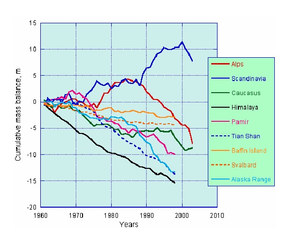
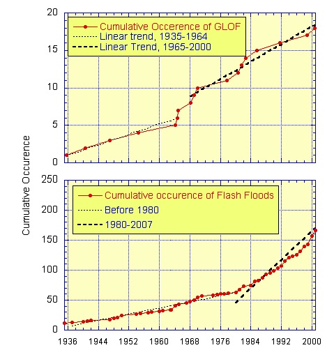


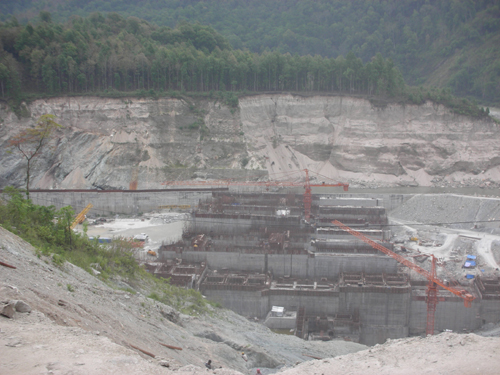


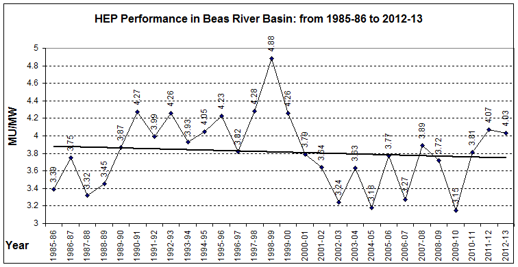
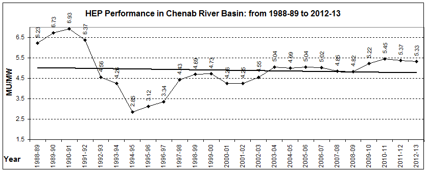


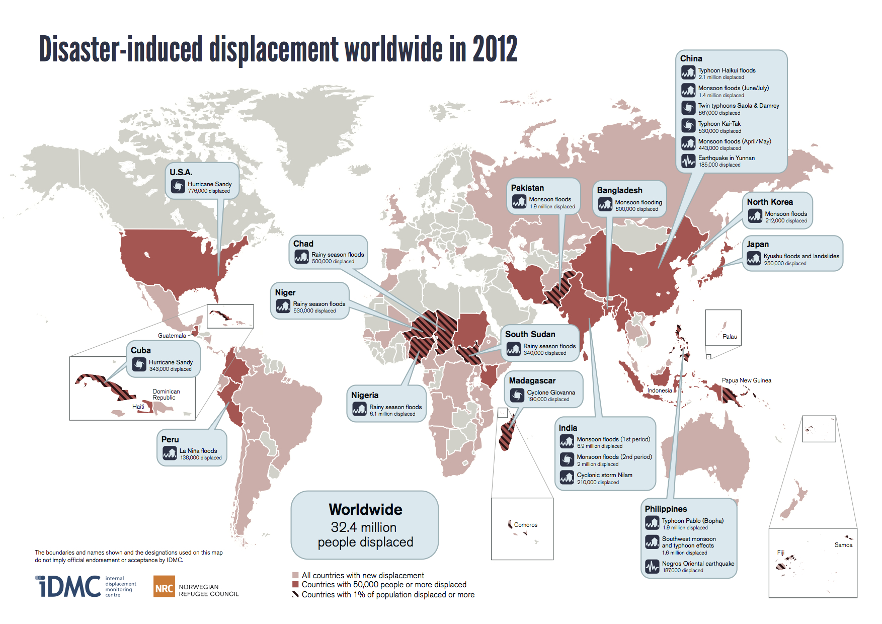
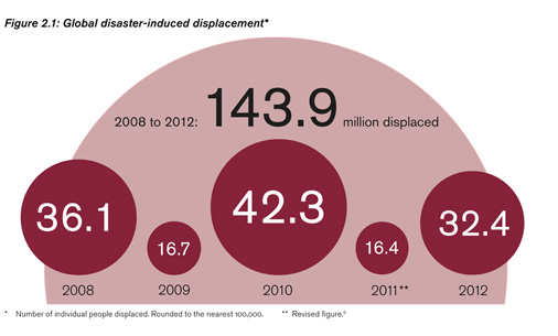
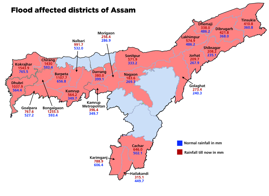
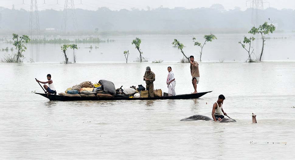
