Last week, a note was in circulation, which listed few border related conflicts between India (Bihar) and Nepal (Parsa). Of the nine points mentioned in the note, seven were directly or indirectly related to either a river, or access to water, or flood protection works. Out of the seven, one issue was with regard to an old concern involving River Pandai, which has witnessed different dimension of cooperation and discord between communities across the Indo-Nepal border in Pashchim (West) Champaran and Parsa districts respectively. However, the note highlight the conflict as a recent one with a specific intent and that was explained as ‘नेपालकीकरतूत : पानीरोकलिया, ताकिएसएसबीकेजवानपरेशानहों‘(Nepal’s handiwork : They stopped the water to trouble the Sashastra Seema Bal (SSB) jawans). After having read the note, I decided to write this piece based on my own understanding and learnings (through direct interactions and personal communication in the past and references) about River Pandai and Bhikhna Thori, to provide a comprehensive perspective.
It was pretty surprising to see the front page headline in The Times of India on Oct 24, 2013[i], claiming that an India China “MoU on Dams Among Nine Deals Signed”. The Hindu headline[ii] (p 12) claimed, “China will be more transparent on trans-border river projects”. Indian Express story[iii] (on page 1-2) claimed, “The recognition of lower riparian rights is a unique gesture, because China has refused to put this down on paper with any other neighbouring country”. It should be added that the news stories on this subject in the Economic Times and the Hindustan Times took the MoU in more matter of fact way.
Proposed Chinese Dams on Yarlung Zangbo Source: SANDRP
Additional information for second half of May However, the actual language of the Memorandum of Understanding on “strengthening cooperation on trans-border rivers” available on website of Press Information Bureau[v] and Ministry of External affairs[vi] gives a very different picture. There is no mention of dams, river projects or lower riparian or rights there. One additional feature of the agreement is that the current hydrological data (Water Level, Discharge and Rainfall) in respect of three stations, namely, Nugesha, Yangcun and Nuxia located on river Yaluzangbu/Brahmaputra from 1st June to 15th October every year[vii] will now be extended to May 15th to Oct 15th with effect from 2014. While this is certainly a step forward since the monsoon in North East India sets in May and also in view of the accelerated melting of glaciers in changing climate, it should not lead to the kind of hype some of the newspapers created around the river information MoU. Moreover, it should be remembered that India pays for the information that it gets from China and what Indian government does with that information is not even known since it is not even available in public domain. How this information is thus used is a big state secret!
Three stations on Yarlung Zangbo – Nugesha, Yangcun and Nuxia (the green spots in the map represent these station)[iv]
Over-Optimistic reading of the MoU? The specific feature of the new MoU about which media seemed excited read as follows: “The two sides agreed to further strengthen cooperation on trans-border rivers, cooperate through the existing Expert Level Mechanism (for detailed chronology of ELM formation, meetings and earlier MoUs on Sutlej and Brahmaputra, see annexure below) on provision of flood-season hydrological data and emergency management, and exchange views on other issues of mutual interest.” The key words of this fifth the last clause of the MoU were seen as “exchange views on other issues of mutual interest”, providing India an opportunity to raise concerns about the Chinese hydropower projects and dams on shared rivers. However, the clause only talks about exchange of views and there is no compulsion for China to share its views, leave aside share information about the Chinese projects in advance or otherwise. On the face of it, the hype from this clause misplaced.
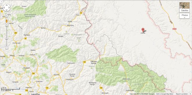
Tsada station on river Satluj (Shown as A in the Google Map)
This was read with first clause: “The two sides recognized that trans-border rivers and related natural resources and the environment are assets of immense value to the socio-economic development of all riparian countries.” Here “riparian countries” clearly includes lower riparian. But to suggest that this clause on its own or read with clause 5 mentioned above provides hope that China will include the concerns of the lower riparian in Chinese projects on shared rivers seems slightly stretched. The clause only recognises the asset value of rivers and related natural resources and environment for all basin countries and it is doubtful if it can be used to interpret that Chinese will or should take care of the concerns of lower riparian.
Thus the rather optimistic interpretation does not seem to emanate from the actual wording of the MoU, but the rather over optimistic interpretation by the Indian interlocutors, possibly including the Indian ambassador to China, who has been quoted on this aspect.
Real Achievement: GOI recognises value of Rivers! What is most interesting though is that Indian government has actually signed a Memorandum that recognises that “rivers and related natural resources and the environment are assets of immense value to the socio-economic development”. This is absolutely amazing and joyful development for rivers. Since there is nothing in the laws, policies, programs, projects and practices of Indian government that says that rivers are of any value. Now that Indian government has actually signed an MoU agreeing to such a value, there is sudden hope for rivers, it seems. Only lurking doubt, though is the word “trans-border” before rivers! We hope the Government of India applies this clause to all rivers, not just trans-border rivers, though we know from past that this hope is one a rather thin ice!!
SANDRP
Annexure:
1. Formation and Meetings of Expert Level Mechanism (ELM) on Trans-border Rivers
20-23 Nov, 2006
During the visit of the President of People’s Republic of China to India in November 20-23, 2006, it was agreed to set up an Expert-Level Mechanism to discuss interaction and cooperation on provision of flood season hydrological data, emergency management and other issues of trans-border rivers between the two countries. Accordingly, the two sides set up the Joint Expert Level Mechanism(ELM) on Trans-border Rivers. The Expert Group from Indian side is led by Joint Secretary level officers. Seven meetings of ELM have been held so far.
19-21 Sept, 2007
In the 1st meeting of ELM the issues related to bilateral cooperation for exchange of hydrological information were discussed.
10-12 April, 2008
In the 2nd meeting of ELM work regulations of the ELM were agreed upon and signed. It was agreed that the ELM shall meet once every year, alternatively in India and China.
21–25 April, 2009
The 3rd meeting was focused on helping in understanding of each other’s position for smooth transmission of flood season hydrological data.
26-29 April, 2010
In the 4th meeting the implementation plan on provision of hydrological information on Yaluzangbu/Brahmaputra River in flood season was signed.
19-22 April, 2011
In the 5th meeting the Implementation Plan in respect to the MoU on Sutlej was signed.
17-20 July, 2012
The 6th meeting of ELM was held at New Delhi where both the countries reached at several important understandings and a significant one of those understandings is – “The two sides recognized that trans-border rivers and related natural resources and the environment are assets of immense value to the socio-economic development of all riparian countries.”
14-18 May, 2013
In the 7th meeting held at Beijing, China where in the draft MoU and Implementation Plan on Brahmaputra river was finalized.
2. MoUs on Hydrological Data Sharing on River Brahmaputra / Yaluzangbu
2002
Government of India and China signed a MoU for provision of hydrological information on Yaluzangbu/Brahmaputra River in flood season by China to India. In accordance with the provisions contained in the MoU, the Chinese side provided hydrological information (Water Level, Discharge and Rainfall) in respect of three stations, namely, Nugesha, Yangcun and Nuxia located on river Yaluzangbu/Brahmaputra (see the map above) from 1st June to 15th October every year, which was utilized in the formulation of flood forecasts by the Central Water Commission. This MoU expired in 2007.
2008
On 5th June, India signed a new MoU with China on provision of hydrological information of the Brahmaputra /Yaluzangbu river in flood season by China to India with a validity of five years. This was done during the visit of the External Affairs Minister of India to Beijing from June 4-7. Under this China had provided the hydrological data of the three stations for the monsoon season from 2010 onward.
2013
During the visit of Chinese Premier Li Kegiang to India the MoU of 2008 has been extended till 5th June 2018.
3. MoUs on Hydrological Data Sharing on River Satluj / Langquin Zangbu
2005
A MoU was signed during the visit of the Chinese Premier to India in April for supply of hydrological information in respect of River Satluj (Langquin Zangbu) in flood season. Chinese side provided hydrological information in respect of their Tsada station on river Satluj (Langquin Zangbu in Chinese, see the map above).
Aug 2010
In order to supply flood season hydrological information on River Sutlej a new MoU was agreed in August 2010
Dec 2010
On 16 Dec 2010, during the visit of Prime Minister of China to India a new MoU was signed to provide hydrological information of Sutlej/Langquin Zangbo River in flood season by China to India with a validity of five years.
April 2011
During the 5th ELM meeting held in April, 2011 an MoU on Sutlej containing the Implementation Plan with technical details of provision of hydrological information, data transmission method and cost settlement etc. was signed in Beijing. The hydrological information during the flood season has been received in terms of the signed implementation plan.
Annexure compiled by Parag Jyoti Saikia
Post Script: Further reading: http://www.thethirdpole.net/2015/11/06/tibet-dams-hold-back-silt-not-water


![Three stations on Yarlung Zangbo - Nugesha, Yangcun and Nuxia (the green spots in the map represent these station)[iv]](https://sandrp.in/wp-content/uploads/2013/10/three-stations-on-on-yarlung-zangbo.jpg?w=663)