Respected Sirs, Oct 26, 2025
1. Shri Pravesh Sahib Singh,
Hon’ble Water Minister,
Delhi Government.
pss-pwd.minister@delhi.gov.in; dspwddelhi@gmail.com
Continue reading “Open Letter Regarding Water Polluting Activities Around WYC in Bawana, Delhi”South Asia Network on Dams, Rivers and People
Respected Sirs, Oct 26, 2025
1. Shri Pravesh Sahib Singh,
Hon’ble Water Minister,
Delhi Government.
pss-pwd.minister@delhi.gov.in; dspwddelhi@gmail.com
Continue reading “Open Letter Regarding Water Polluting Activities Around WYC in Bawana, Delhi”(Feature Image: Asan river flowing through residential areas of Sevala Kalan upstream Chandrabani temple)
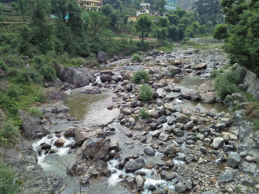
Despite being an important tributary to the Yamuna River in Shivalik hills of Dehradun, the Asan appears among the least explored and documented rivers. While, most of the people believe and even available online maps depict Chandrabani temple as origin place of the Asan, a field visit to track the river course reveals some interesting information.
This part one of photo blog documents the river course in its founding catchment sharing pictures and our field observations about the river’s origin place, past history and present situation. The second part of the photo blog will cover the remaining length of the river lying between Chandrabani temple and Asan barrage.
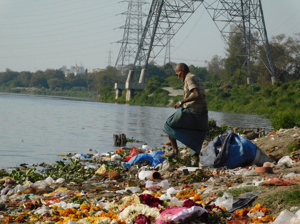
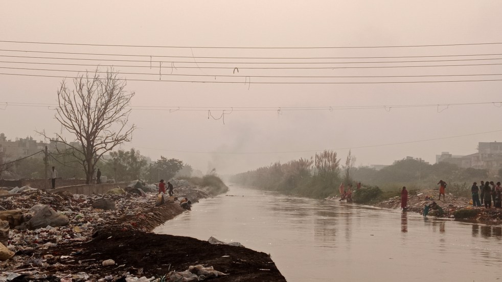
(Feature Image: Solid waste strewn along east bank of polluted river Yamuna near Geeta Colony bridge, Delhi on March 09, 2024. Bhim Singh Rawat/SANDRP)
The Parliamentary Standing Committee on Water Resources has submitted its 27th report titled “Review of Upper Yamuna River Cleaning Projects upto Delhi and Riverbed Management in Delhi” to the Parliament on 6 Feb 2024. The 113 paged report has two parts first on Narration and second on Observation and 25 Recommendations. The first part of the report has XI chapters dealing with various issues of River Yamuna.
SANDRP here presents a detailed chapter wise overview of the key observations made by the Committee based on the replies mainly from Department of Water Resources, River Development & Ganga Rejuvenation (DoWR, RD & GR) along with the Committee’s recommendations and some comments by SANDRP.
Continue reading “Yamuna Parliamentary Committee Report Missing on River Governance”(Feature Image: DN 8 full of untreated effluents near GTK road on May 13, 2023. Bhim Singh Rawat)
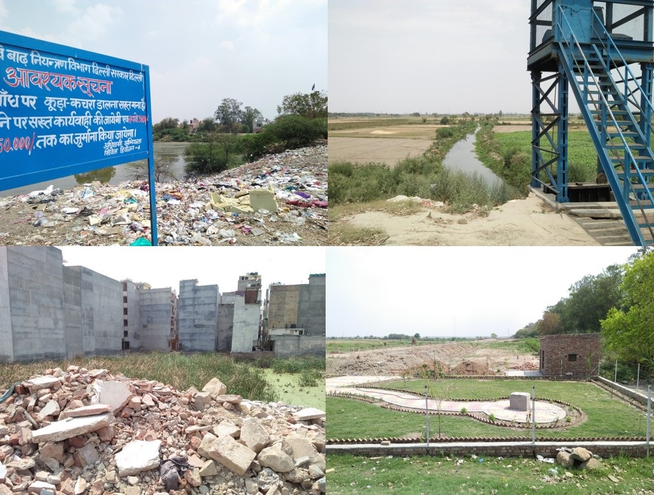
In the past, the Storm Water Drains (SWD) used to be seasonal streams feeding Yamuna river in upper segment of Haryana. After introduction of canal based irrigation system, most of the SWDs dissected by Western Yamuna Canal (WYC) networks have been converted into flood escape channels.
In recent decades, many of these SWDs have been degraded into waste water disposal drains. The Dhanaura escape in Karnal, Drain Number (DN) 2 in Panipat and DN 6 in Sonepat districts of Haryana state are glaring example of the deliberate abuse.
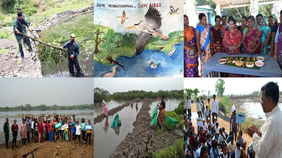
Continue reading “Yamuna Basin Storm Water Drain No 8 now Effluents Disposal Drain”Pondicherry Collector led the revival of over 300 waterbodies The then District Collector and present Secretary to the Chief Minister, A. Vikranth Raja, stepped in with the idea of digging into revenue records to locate the region’s traditional water bodies. It all started with a query raised at the meeting. When someone asked if Karaikal had the capacity to store 7 tmcft of river water allotted by the Cauvery Water Disputes Tribunal, “the response from officials was an emphatic no,” says Selvaganesh, Assistant, District Collectorate of Karaikal.
In June 2019, in the tiny coastal enclave of Karaikal, administration officers brainstormed about putting in place a sustainable water resource management model for the town’s two lakh people. They found 549 ponds within a small territory spread over 157 sq. km. 40% of these water bodies were in various stages of extinction. Most of them turned out to be dumping yards.
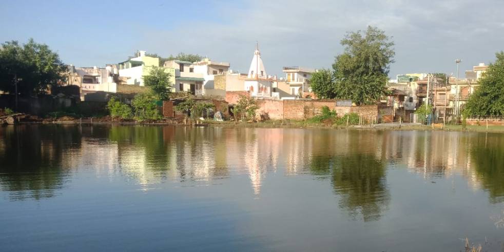
Continue reading “Wetlands 2020: Positive Developments”The monsoon rains of August 2020 have brought a soothing smile on the faces of villagers working towards revival of Patodi Johad a traditional water body in Narela, a bustling sub-city in North Delhi.
The greenery, cleanliness created over past one year around the pond with joint effort by youth, women, elderly and children have been now complemented by rainwater flooding the pond making it one of best locations in Narela where native plants, water body, blooming garden is thriving.
The sustained efforts by the villagers have not only brought positive change in society by involving people of all ages, but also leading to rebuilding of lost eco-system and improving micro climate. The biggest benefit is slow but sure improvement in ground water table. This account presents glimpses of how this happened.
Continue reading “PATODI JOHAD: Narela Youth Rejuvenate a dry Pond”Union Territory of Chandigarh enjoys ‘City Beautiful’ tag for better planned urban development. Undoubtedly the city has wide roads, abundant green patches, well planned residential sectors, public amenities, cyclist tracks etc.; however dumping of solid waste and untreated sewage around its periphery shows that the city performs poorly in managing its water and natural sources.
The story of Faidan Nizampur also known as Faidan Pind drain near Airport is an apt example showing that while city manages to get beautiful tag, the rivulets and lives of people around it have turned miserable by increasing pollution load and other issues.
Continue reading “Chandigarh: Faidan Pind Drain Shows Ugly Side of ‘City Beautiful’”
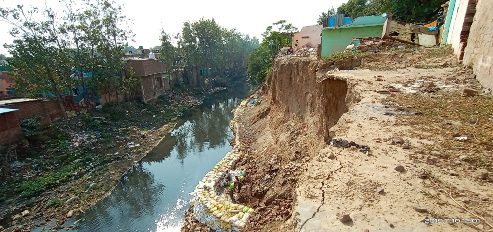
On August 21, 2019, the first big flood spell of monsoon season 2019 has passed through Delhi. The river swelled to cross first warning level 204.00 metre and then danger level 204.83 metre at Old Railway Bridge (ORB) Delhi, finally receding from 206.6 metre which is 0.89 meter short of 207.49 Highest Flood Level (HFL) set in 1978.
The delayed and much awaited flood spell hit the city after highest ever recorded discharge of 8.28 lakh cusec water for two hours from Hathini Kund Barrage (HKB), Yamuna Nagar in Haryana on August 18, 2019 at 05:00 pm and 6:00 pm. The highest since the commissioning of HKB in 2000. The water release this year has also surpassed the discharge of 7.09 lakh cusec the previous highest discharge recorded at Taje Wala Barrage (TWB) during the highest flood recorded in River Yamuna in September 1978. The British era TWB barrage, some 6 kilometre upstream of HKB was washed away in 2010 floods.
Continue reading “Aug 2019 Yamuna Flood: Floodplain Encroachments Exposed Again”
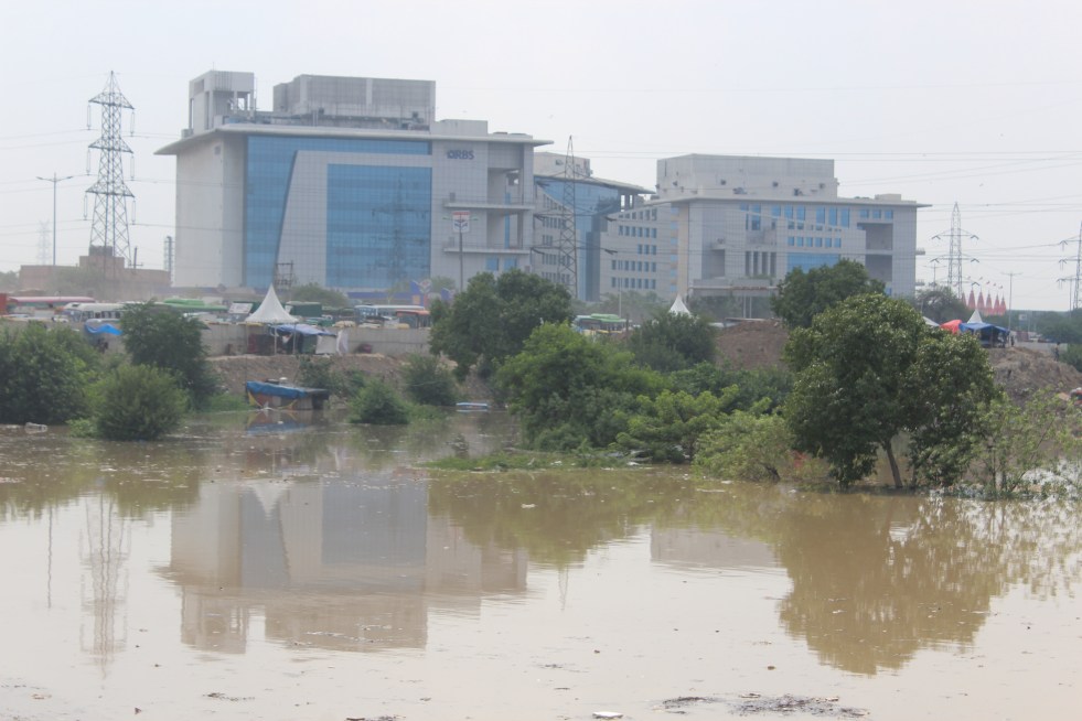
The stretch of Yamuna River & its floodplain lying between Palla and Wazirabad Barrage in Delhi is still in reasonably good state. Though bisected by an embankment, the floodplain is free of too many recent major encroachments. The River keeps meandering between physical boundaries of Delhi and Gaziabad district of Uttar Pradesh on the other side. The average width of floodplain from embankment to embankment is 2 kilometres. The width of active river current varies from 200-300 metres.
Most parts of the floodplain on both sides of this embankment are under agriculture. The crops grown here includes paddy, vegetables and floriculture as cash crops apart from wheat, traditional riverbed crops of melons, cucumber, tomato and bottle guards etc. Use of chemicals is also growing. There is not much information available about the impact of chemical farming on floodplain and river eco system.
Continue reading “Abuse of Remaining Yamuna River Floodplain in Delhi Continues”
Ramganga (West) River originates from the western part of Dudhatoli reserve forest lying between Thailisain block in Pouri and Gairsain tehsil in Chamoli districts of Uttrakhand state. It is an important tributary of National River Gaga. The total length of the river is about 596 km. For first 200 km the river flows in Uttarakhand state and the remaining length falls in the state of Uttar Pradesh. Before it descends into plains, it is impounded by Kalagarh dam inside Jim Corbett National park.
Continue reading “Ramganga West – A Ganga Tributary or A Garbage River?”