Above: A girl from the Par Basin. With drinking water problems plaguing her village and the impending diversion project either from Gujarat or Maharashtra, her hardships will only increase. Photo: Parineeta Dandekar
Even as the second meeting of the Special Committee for Interlinking of Rivers was held on the 6th January 2015[i], the Union Minister of Water Resources, River Development and Ganga Rejuvenation Sushri Uma Bharti sought “co-operation of various States in this project” and said that “States can discuss their apprehensions if any, in the next meeting of the committee.” She informed the meeting that on 07 January 2015, she will meet Chief Minister of Maharashtra Shri. Devendra Fadnavis to discuss Damanganga-Pinjal and Par-Tapi-Narmada link projects.
River Netravathi in the upper reaches Photo: Parineeta Dandekar, SANDRP
Like a many-headed serpent, Yettinahole (Netravathi) Diversion Project refuses to die. Every time one of its head is cut, it grows a new head.
Following criticism of the Project Report [i](based on which Karnataka Government had already made budget provisions in 2013), a new DPR of the project has been prepared in December 2013 by EIT RIP JV [ii] which tries to amend blatantly illegal stands taken earlier. However, after scratching the surface, it is clear that the DPR is just as illegal and dangerous as the interim Project Report was.
Yettinahole, or rightly the Netravathi Diversion Project has always been a political project, visualized to earn political mileage and brownie points. Veerappa Moily originally from Dakshin Kannada, moved to Chikkaballpur constituency in 2009, from when he started pushing the project strongly. As the Environment Minister, Moily also laid the foundation stone of the project in Chikkaballapur, just before the Loksabaha Elections in March 2014 [iii]. Strategically, the stone was laid in Chikkaballapur and not in Hassan, from where the water actually be diverted. No political party has opposed the project consistently.
Even before a complete DPR, Karnataka 12-14 Budget of the Congress Government allocated nearly 2800 crores for this scheme. The current govt lost no time and directly awarded contracts worth nearly 1000 Crores to Hindustan Construction Company, in a joint venture with GVPRL, without any clearances or any public consultations[iv].
Before the laying of the foundation stone of the project, SANDRP had presented a detailed analyses if the Project Report proving how the project is violating Environmental Protection Act by evading Environmental Clearance.[v] A number of eminent personalities from Karnataka had jointly written to the MoEF to appraise the Project for EC. In response to this, the MoEF had written to the Karnataka Govt and Karnataka Neeravari Nigam Limited (KNNL), seeking clarifications on the nature of the project. Although this move was triggered due to the submission made by SANDRP and other groups, we never saw KNNL’s response despite specifically asking for it. We only saw MoEF’s lame justification, bailing out KNNL and Karnataka Government and turning a blind eye to the huge impacts of the project.
Students protesting against Yettinahole Project Photo: DaijiWolrd
When Karnataka CM Siddramaiah was about to lay the foundation stone along with Mr. Moily, SANDRP wrote an open letter to him[vi], as the Environment Minister, asking a direct question as to how can he himself formally initiate a scheme which is blatantly violating laws governed by his own Ministry. Following this, the ceremony was cancelled[vii], only to be held surreptitiously later.
During all this, there was huge and unprecedented opposition to the project from Dakshin Kannada and Mangalore. Farmers, students, workers, women groups all came together, united in their opposition against a project that would divert their Netravathi. People stopped trains, organized hundreds of dharnas, boycotted voting, organised signature drives, etc. Leaders in all hues came together in a rare show of discontent. On the day of foundation stone laying, people in Dakshin Kannada voluntarily observed a strict Bandh. Funnily enough, even the beneficiary district of Chikkaballpur opposed the project as the 2.82 TMC water that it would be getting after so much of fanfare was too meager, in the face of the grand promises of lush fields and no worries.
More Protests against the Project Photo: The HinduProtest in Hassan against Yettinahole Photo: The HinduProtesters stopping a train Photo: News Karnataka
Despite these unprecedented protests and in the face of 2014 Loksabha Elections, foundation stone was laid on a dais in Chikkaballapur. The dais was burgeoning under the weight of several political strongmen.
This event stands out as an example of undemocratic behavior for an elected government.
Foundation Stone laying Ceremony Photo: The Hindu
The Government of Karnataka did not hold a single public meeting in Dakshin Kannada, trying to understand and address people’s apprehensions. When eminent personalities from Dakshin Kannada planned to hold a National Consultation on Yettinahole Diversion in NIT Suratkhal in August 2013, the meeting was cancelled at the last minute due to political pressure on the organizers.
As things stand now, the project does not have Environmental Clearance, Forest Clearance, Wildlife Clearance, has not started rehabilitation and resettlement of over 10 villages that it will submerge, but its work can start at any moment.
SANDRP accessed the Detailed Project Report (DPR) of the Project from local activists, who obtained it under RTI. Analysis of the DPR reveals a number of issues. KNNL has drastically changed the initial Project Report, avoiding mention of contentious issues we had raised like hydropower generation, irrigation component, etc., thus strongly vindicating the objections raised. However, going further, it is clear that these changes are cosmetic. Deeper problems and severe unstudied impacts of the scheme remain.
SANDRP analyzed 4 volumes of the DPR and Annexures of the Project. What follows is some myth busting about the Yettinahole Detailed Project Report.
1. What is the Current Project? Is it different from the last Project Report?
While the Project Report of June 2012 was titled: ‘Scheme for diversion of flood water from Sakleshpura (West) to Kolar/ Chikkaballapura Districts (East)’, the DPR dated December 2013 has taken out all the random stuff on Kolar and Chikkaballapura and simple calls it as “Yettinahole Project”.
Current Project as per the DPR, is divided in Two Phases.
Phase I: 8 weirs will be built in the Western Ghats, on the streams Yettinahole, Kerihole, Kadumanehole and Hongadahalla. It also includes several pump houses next to weirs, raising mains that run for several kilometers are nearly 5 kms wide, 3 Delivery Chambers (DC) and a gravity canal taking waters from Weirs 3, 4 and 5 to Doddanagara (DC 3) in the Western Ghats forests.
From the weirs, 85 cumecs (Cubic Meters per second) water will be drawn 24*7 in the six months of June-November.
This will be delivered through 4 Delivery Chambers with the last DC: DC 4 at Haravanahalli.
Phase II: From DC 4, water will be diverted to a canal running 274 kilometers, cutting across the ridge line dividing Cauvery and Krishna Basins and culminating at a Balancing Reservoir at Byragondlu and Thumbadi, in Koratgere Taluk. Thumbadi Reservoir will store about 3 TMC water and will submerge nearly 700 hectares of land and three villages[viii] while Balancing Reservoir at Byragondlu will store 5.7 TMC water and will submerge 7 villages [ix]and an area of about 2000 hectares. The Reservoir at Devaranyadurga, which was proposed in the Project Report has been replaced by these two.
It includes construction of several storage tanks and reservoirs for en route water supply. It will also delivery water to T.G. Halli and Hesarghatta Reservoirs, which supply water to Bangalore. It also plans to supply water to Devanhalli Industrial Area.
The project envisages constructing 7 additional storage reservoirs and 10 major canals. Water will also be used to fill morethan 500 Minor Irrigation (MI) Tanks in many districts and taluks.
It is amazing how the project envisages filling MI Tanks to 50% capacity: The DPR says that water will be pumped and released to the highest point and an additional sluice gate will be made to all MI tanks to let water flow into the cascading MI tank. This sounds highly impractical.
The project also includes constructing over 100 bridges in villages and nearly 100 road brides on major roads.
So although details have changed, the basic of the project remain the same. There is no change in Western Ghats, except for the fact that not 24 TMC, but 47 TMC water will be pumped now!
Survey markings in Sakaleshpur on peoples homes. People had no idea why the survey was carried out and no information was given. Photo: Parineeta Dandekar
2. What is the cost of this current Project? Can the cost be borne easily by KNNL or Karnataka Government?
The cost of the Project as per DPR stands at nearly 13000 Crores as per 12-13 price line. This exceeds the entire 13-14 years’ budget of the Karnataka Water Resources Department, which stands at 8007 Crores and is nearly five times the annual budget of KNNL, the implementing agency.[x] This is a colossal amount of money to spend to convey approximately 7 TMC water to Kolar and Chikkaballapur and other nonspecific projects.
3. Who are the Main Beneficiaries? Will Kolar and Chikkaballpur really get 24 TMC water as promised?
The supposed beneficiaries of the project are several towns, villages, cities and industrial areas[xi] and No, Kolar and Chikkaballapur again lose out and get only about 7 TMC water.
4. Then who will be getting this water?
The DPR puts out a diffuse list of beneficiaries ( see Annex below) including Bangalore urban area through TG Halli and Hesarghatta Reservoir and the Devanhalli Industrial Hub. There are no population projections or future need calculations for this region like all other regions and at no place does the DPR say that water will go to Bangalore. However, TG Halli and Hesaraghtaa reservoirs are both used by the Bangalore Water Supply and Sanitation Board [xii]for Bangalore City and in the last Budget, the government had itself stated that water will be used for Bangalore Urban Area’s needs.
How Bangalore treats its local water bodies Photo: The Alternative
A review of beneficiaries:
Bangalore gets 3 TMC water: The DPR says that about 3 TMC water will be released to TG Halli and Hesargahtta Reservoirs and for the Devanhalli Area.
Minor Irrigation Tanks and hence irrigation gets maximum water at 9 TMC: Nearly 9 TMC water will be used for filling more than 500 MI tanks upto 50% of their live storage capacity. This water will be supposedly used for “groundwater recharge”. There are several participatory, cheap and sustainable ways for recharging groundwater, which seem to have been rejected in favor of long distance transfer. In any case, this groundwater recharge will be used for agriculture, as most of the agriculture there depends on groundwater and hence, the project qualifies for Environmental Clearance.
The project is being pushed for the drought affected taluks in Kolar Chikkaballapur and Tumkur and even a brief glance at the calculation shows that even in 2023-24, the drinking water demand of these places cumulatively will be just 12 TMC! Then why are we diverting 24 TMC water, double of the ten years’ estimate?
5. What is the basis for diverting 24.01 TMC?
The report provides no justification about why 24 TMC is supposed to be diverted. In fact, after population calculations and making provisions for drinking water supply for the beneficiary districts and villages, the DPR simply states : “This has resulted in a balance availability of 8.9 TMC” . This is a strange statement to make. What is meant by “balance availability”? Is there compulsion for diverting 24 TMC by hook or by crook from the Western Ghats?
6. 24 TMC Diversion? No 47 TMC Diversion!
The project envisages diverting 85 cumecs (Cubic Metres per second) water[xiii], purportedly for six months of June-November. The DPR states that pumps will function 24*7 during this period. Even a simple, back-of-the-envelope calculation indicates that 85 cumecs diversion leads to nearly 47 TMC diverted over six months and not 24 TMC, as is claimed.
7. Was there a detailed hydrological study to arrive at 24 TMC diversion?
The proponents have no flow data from individual streams. The 13,000 Crores project is to be based on shoddy hydrology data.
They have used gauge data from Bantwal across Netrvathi, which is approximately 60-70 kilometers downstream and in a completely different eco-region from the hills. This gauge data is simply extrapolated based on catchment area of each stream. This is highly unscientific.
The earlier Project Report used an entirely different method for calculating this yield, based in rainfall in individual catchments. Interesting to see that although to different methods were used by two different reports, divertible yield is exactly the same to the last decimal point of 24.01 TMC!
The fact of the matter is that there have been no scientific studies to find out the level of safe diversion. The DPR makes a fantastic statement in conclusion to the effect that:
“According to the revised computations, the divertible yield has been assessed as 22.14.TMC. However, Prof.Rama Prasad , who has conducted the Hydrology studies has opined that the yield of 22.14 TMC at 50% dependability is very much on a conservative side and 24.01 TMC of divertible yield is available across the streams. This has been taken note off and for the present proposal, 24.01 TMC of water has been considered as the divertible yield from the selected streams to proceed further regarding finalization of the scheme in total.”
This just shows the random way in which divertible yield has been fixed!
8. How about the downstream Impacts of this diversion, which was the main reason for protests in Dakshin Kannada and Mangalore? Were the impacts studied?
There has been NO assessment of downstream water needs or impacts of this diversion on the downstream people or ecosystems. The DPR just ‘assumes’ that there will not be any impact on downstream users of ecology!
This is evidently misleading. One example of the problem in such assumption is that the flow data of Hongadahalla maintained by KPCL (given in Annex) indicates that flow in streams like Hongadhalla in August near the gauging point, has not exceeded even 20 cumecs. However, the according to the DPR[xiv], arrangement has been made to divert a whopping 30 cumecs from Hongadhalla from Weir 7 during June-November. This means that in the downstream, the rivulet will be rendered dry.
9. Was Impact Assessment for Western Ghats conducted?
The project proponent has not even clarified as to what will be forest land required for diversion. The section on Impact Assessment in the EMP deals largely with the beneficiary region without dealing with impacts on Wesetrn Ghats at all. There has been no study on eflows as per the HLWG (High Level Working Group on Western Ghats/ Kasturirangan Committee Report)report, no study of estuarine fisheries, no study of drinking water needs.
Cornered Wildlife in Sakaleshpur, leading to crisis Photo: News 24 7
10. Will there be profound impacts in the downstream region?
Yes. Yettinahole Project will “divert” water out of the basin and unlike most other irrigation or hydropower projects, the water will be permanently lost from the basin. The ecosystem and livelihoods in the downstream are closely linked to the hydrology of the Netravathi. In fact even in June, which is supposed to be a “peak season” for diversion, Mangalore and other parts of Dakshin Kannada have been facing water shortages[xv]. In addition, there are several estuarine and riverine fishermen dependent on the Netravathi for their livelihoods. There are many industrial areas, SEZs coming up in Mangalore which will be needing more water. While there has been a prospective study of the population and water demand growth of the beneficiary region in the DPR, there has been not even a mention of Mangalore and its increasing needs in the future in the DPR, highlighting the bias of the proponents.
There are several functioning mini hydel projects on the individual streams as well as tributaries which depend on the assured flow from upstream. They have not even been consulted before this decision was taken.
Drying Thumbe Dam which supplies water from Netravthi to Mangalore town Photo: The Hindu
11. Will there be a severe impact on Ecology and Wildlife?
The project falls within 10 kms boundary of the Pushpagiri Sanctuary, one of the specific World Heritage Sites in the Western Ghats[xvi]. The entire region has exceptional biodiversity. The project also affects the Mysore Elephant Reserve.
The region has exceptional fish biodiversity, with several new species [xvii]being discovered from the region. There have been efforts to declare this area as a specific fish sanctuary.[xviii]Despite this, the Environmental Management Plan of the DPR states that the fish diversity in most streams is “Poor”. This is a very irresponsible and misleading statement.
Man Animal Conflicts in Sakaleshpura are on a rise. Mega infrastructural activities envisaged in Yettinahole Project will worsen the situation further. There has been no mention of this.
Canara Pearlspot, an endangered fish of many such species found in Netravathi Photo: Arkive.org
12. Considering the impacts and the strong opposition from Dakshin Kannada, were any public consultations held?
No. there has not been a single open public consultation held by the proponents or the Karnataka Government in the affected region. This indicates lack of respect for democratic values and transparency. Shockingly to the question: “ Have-public debates about utility of projects been held and the response thereof outlined in the Report?” has been answered as “Yes” in the DPR.
In fact there has been no such report in the DPR.
The DPR also states: 1.14: “Many public meetings have been held by the Govt. to make the people aware of the importance of the scheme both in the initial reaches and the end reaches of the project.”
More protest Marches in Mangalore Photo: Daiji World
This is entirely false as no such meeting has been held on Dakshin Kannada where informed discussions can be held.
To conclude:
Yettinahole diversion or Netravathi Diversion Project is an extremely costly ( 13000 Crores +) project of the Karnataka Government. It has been based on weak hydrology, nonexistent impact assessment of the downstream region, no Forest Clearance, no Wildlife Clearance and no public consultations. It is violating Environment (Protection) Act 1986, Forest (Conservation) Act 1980 and Wildlife (Protection)Act 1972. As has been proved by SANDRP, Karnataka has violated Environmental Laws in the recent past[xix].
The project provides no justification for diverting 24 TMC, plans to divert more volume than that, most of which is meant for urban areas and irrigation, without options assessment of cheaper and more sustainable options.
The project has illegally awarded tenders worth Rs 1000 crores without clearances.
In the interest of ecology, downstream population of Dakshin Kannada, public resources, wildlife, World Heritage sites and even future generations, at least until we have basis for informed decisions including a credible EIA, SIA, Options assessment and participatory decision making process, Projects like Yettinahole need to be shelved. Already multiple PILs against the project have been filed in the High Court and routed to the NGT. We hope NGT will also take a strong view on the serious issues involved here.
Severe downstream impacts and drying up of streams due to Yettinahole project reminds one of the tale of Sage Durvasa, meditating on the banks of the Tunga, not very far from Dakshin Kannada. Durvasa loved the river and was known for his short temper. As Bheema dammed the flowing River, Durvasa was agitated to see dried up river bed in the downstream. Yudhishthira saw this and advised Bheema to break the dam himself, to avoid the wrath of Sage Durvasa. Bheema relented and broke the dam, to allow the free flow of the river once more. (One of India’s first decommissioned dams?)
Let us hope that Netravathi flows unhindered and continues to support human and non-humans alike like she has been doing for centuries. Even for the areas claimed to be benefiting from the project, there are cheaper, sustainable and credible options available than this mega project.
Tumkur district comprising of areas in Palar and Pennar basins including Chiknayakanahalli and Sira Taluks along with selected villages in Tiptur and Gubbi Taluks.
Hassan district comprising of villages in Arasikere taluk
Chikamagalore district comprising of selected villages in Kadur taluk
Ramanagara district
Bangalore Rural district comprising of Nelamangala, Doddaballapura, Devanahalli and Hoskote Taluks
Augmenting the water to T.G.Halli reservoir
Augmenting water to Hesaraghatta reservoir
Drinking water supply to Devanahalli Industrial area and surrounding areas
Providing water for tank filling purposes to fill selected M I Tanks to their 50 % capacity (average) in the M I tanks falling under Palar and Pennar basins and Arasikere taluk
The Mohanpura Project The proposed Mohanpura dam is to be constructed by the Madhya Pradesh Water Resources Deparment near the village Banskhedi of District Rajgarh, Madhya Pradesh on river Newaj in ChambalRiver Basin. The earthen dam project envisages irrigation of 97,750 ha, including the irrigable area of 62250 ha in Rabi and 35500 ha in Kharif in Rajgarh and Khilchipur Tehsils of Rajgarh district. The Environmental Impact Assessment (EIA) dated May 2013 has been done by WAPCOS, an agency under Union Water Resources Ministry.
Site of the proposed Mohanpura Dam (Source: EIA)
The EIA and the EAC We have provided below some critical comments on the EIA, these are only indicative in nature and not comprehensive. These comments were sent to the Ministry of Environment and Forests’ Expert Appraisal Committee (EAC) on River Valley Projects for its meeting in June 2013 and further comments for Sept 2013 and Nov 2013 EAC meetings. We were glad that EAC asked the project proponent to reply to our submission in detail. But we did not get any reply directly either from the project proponent or MoEF. We several times checked the relevant section of MoEF website before the Nov 11-12, 2013 EAC meeting and did not find any additional submission from the project proponent or EIA consultant except the EIA and earlier submissions. We also wrote to the EAC and MoEF officials about this absence of any response from the proponent or the EIA consultant and they did not respond to our emails.
However, while looking for something else, on Nov 13, 2013, on clicking the EIA (which we assumed was the old EIA), what we got was the Oct 2013 response from the project proponent that supposedly included the response from WAPCOS to our submission. This seems like an attempt on the part of MoEF officials to camouflage/ hide the reply so that the reply is put up, but we do no get a chance to review and respond to it. This is clearly wrong and we have written on Nov 13, 2013 to that effect to the MoEF director Mr B B Barman who is also member secretary of the EAC.
Location map of the Mohanpura Project (Source: EIA)
In any case, the WAPCOS reply of Oct 2013 does not really provide adequate response to any of the points we raised as we have discussed in the following sections. If the EAC had applied its mind, EAC too would have come to the same conclusion. However, if EAC decides to recommend clearance to the project based on this reply by WAPCOS, it will not only show lack of application of mind and bias on the part of the EAC, the project clearance would also be open to legal challenge.
In what follows we have provided main critiques of the EIA and the project.
EIA does not mention that the project is part of Inter-Linking of Rivers The Mohanpura dam is part of the Government of India’s Interlinking of Rivers scheme, specifically part of the Parbati-Kalisindh-Chambal (PKC) scheme, see for example the mention of Mohanpura dam on Newaj river in salient features of the PKC scheme at: http://nwda.gov.in/writereaddata/linkimages/7740745524.PDF, the full feasibility report of the PKC scheme can be seen at: http://nwda.gov.in/index4.asp?ssslid=36&subsubsublinkid=24&langid=1. This hiding of this crucial information by the Project Proponent is tantamount to misleading the EAC and MoEF and should invite action under EIA notification. The claim by WAPCOS (through their response in Oct 2013) that this was mentioned in DPR is clearly not tenable since this should have been mentioned in the EIA.
Much bigger Mohanpura Reservoir proposed compared to the PKC proposal It is clear from the perusal of the Feasibility of the PKC link given on the NWDA link that the project now proposed by the Govt of Madhya Pradesh is much bigger and actually an unviable scheme. The Gross and live storage of the NWDA scheme is 140 MCM and 52.5 MCM, where as the proposal now before the EAC has gross storage of 616.27 MCM and live storage of 539.42 MCM (page 1-328 mentions Live storage as 616 MCM, showing another instance of shoddy work of WAPCOS), which means the live storage proposed now is more than ten times the live storage proposed in NWDA scheme. It may be noted that there is less than 4% difference in catchment area of the two schemes, the NWDA site was slightly upstream with the catchment area of 3594 sq km, compared to catchment area of now proposed scheme being 3726 sq km, the difference between the two is only 132 sq km.
This does not warrant or justify more than ten time higher live storage. In fact the NWDA scheme had the proposal to transfer 464 MCM from the Patanpur Dam to the Mohanpura dam and yet, under the Mohanpura live storage capacity proposed under NWDA scheme was much smaller. It is clear that the proposal before NWDA is completely unviable proposal and should be rejected.
No justification for increasing the live storage capacity OVER TEN TIMES This is a very serious issue and unless this is satisfactorily resolved, EAC should not consider the proposal.
Here it should be point out that the following discussion in the 67th EAC meeting regarding the SANDRP letter is misleading: “The developers were asked to clarify doubts raised in the above letters relating to the project features that contradict with the assumptions made in the NWDA study of Parbati – Kalisindh – Chambal Scheme, a major issue is that the NWDA scheme envisaged a gross and live storage provision of 140 and 52.5 MCM respectively against the present proposal 616.27 and 539.42 MCM respectively because the NWDA proposed transferring 464 MCM from Patanpur dam to Mohanpura Reservoir to reduce the large submergence of Mohanpura Reservoir. The developers clarified that the NWDA scheme has not been accepted by the M.P. Government and is not likely to be implemented in the near future. The M. P. Government wants immediate implementation of Mohanpura Project for poverty alleviation of the backward Rajgarh District.”
The issue is not only about how NWDA plans differed from the current proposal in terms of transferring 464 MCM water to Mohanpura dam from Patanpur dam and transferring 403 MCM from Mohanpura dam to Kundaliya dam. Net effect of these two transfers is addition of less than about 61 MCM water to Mohanpura dam in NWDA proposal from outside the Newaj basin. In spite of this addition, the storage capacity of the Mohanpura dam in NWDA proposal is HUGELY LOWER than in the current GOMP proposal. There is clearly no justification for such huge storage capacity from any angle. Even the water use plan has exaggerated figures and does not change even with changed cropping pattern. The issue is the viability, desirability, need and optimality of the ten times larger reservoir than was NWDA proposed earlier.
Unfounded assumption about water availability The project assumes huge yield of 745.2 MCM, much higher than that assessed by the Chambal Master Plan, without assigning any reason. This seems to be a ploy to push for unjustifiably huge reservoir. This is clearly wrong and the proposal should be rejected. The reply by WAPCOS that “The calculated yield of dam is approved by Bureau of Design of Hydel & Irrigation Project (BODHI), M.P.” is not convincing since BODHI is government of Madhya Pradesh organisation and in any case, their approval letter and methodology details have not been attached. In any case, Newaj being in interstate Chambal river basin, it will need vetting by the interstate Chambal River Board or credible independent body.
Inadequate assessment of upstream water requirement The EIA does not do proper or adequate assessment of current and future water requirements of upstream areas and allocates almost all available water in the catchment to the project in a bid to justify unjustifiable project. The figures given in table 10.9 are not even substantiated with any basis and hence are far from adequate in the context. The PP has also not responded to the EAC query about the upstream water demand.
Unjustifiable submergence The proposal entails submergence of 7051 Ha, almost three times the submergence as per NWDA scheme of 2510 ha. The project proponent has hugely underestimated the number of affected families to 1800 against private land acquisition of 5163 ha. They have amazingly, allotted just 132 ha of land for R&R, when land for land provisions under the MP R&R policy will require much more than 5000 ha just for R&R. The social impact assessment has not been done at all. In fact the phrase Social Impact Assessment or Social Impact does not figure in the entire EIA, when the National Green Tribunal has been laying such a stress on SIA.
The whole social impact assessment of the proposal now submitted is shoddy. It is clear the huge displacement is unjustified, and the project proponent has no interest in even doing any just rehabilitation. The PP has not explained the justification for three times increasing the submergence area compared to the NWDA proposal.
Interstate aspects ignored The project is coming up on an interstate river basin and will have clear implications for the downstream state of Rajasthan, but there is no mention of this in the EIA. Several meetings have also happened between Madhya Pradesh and Rajasthan about the PKC link mentioned above. The Government of India has prioritized this link, but by taking up this project unilaterally without consent of Rajasthan or Centre (Ministry of Water Resources) the Madhya Pradesh government is violating the interstate and federal norms. The EIA does not even mention any of these issues.
Underestimation of Land required for Canal The project has command area of 97750 ha and claims that it will require just 152 ha of land for canals (table 2.6 of EIA), which is clearly a huge under estimate and is not based on any real assessment. The project will require several times more land for the canals and will have related social and environmental impacts which have not even been assessed. The response from WAPCOS that this is because most of the water conveyance system is underground is far from adequate since an assessment of land requirement should still have been done and a lot of land would still be required at the end of water conveyance system.
No Command Area Development Plan The EIA report (May 2013) mentions CAD in two sections: Section 2.8 and 10.9. However, perusal of both sections show that neither have full description of Command Area Development Plan or adverse Impacts of the project in the Command Area including drainage, health, biodiversity and other issues.
Shocking statements in Command Area Development Plan The CAD now annexed in the Additional information (dated Aug 2013) makes some shocking statements. e.g. It says: “GCA of the project is 928680 ha…” with an extra “0”. This seems to suggest that the EIA consultant is callous.
The CAD further says: “Maximum height of the spillway above the ground will be 47.90 m (measured from river bed level to top of the spillway bridge). Maximum height of spillway from expected foundation level will be 47.90 m.” So the height of the spillway above the riverbed and above the foundation is same! This means that there is no foundation of the dam below the riverbed level! This again shows the callousness and lack of understanding of basic concepts by WAPCOS.
Section 2.9 of CAD says: “The groundwater development is of the order of 6.9% to 8.7% in the command area blocks.” In reality, as the table 2-3 just below this statement shows, the groundwater draft is 69 to 89%.
Section 3.1 of CAD says: “…the catchment area intercepted upto Mohanpura dam site is 3825 sq.km.” The last sentence in the same para says: “The catchment area intercepted at the dam site is 3726 sq.km.” Such figures for the catchment area upto Mohanpura dam keeps appearing in the documents.
The CAD should start with clear statement of HOW MUCH OF THE PROPOSED COMMAND AREA IS ALREADY IRRIGATED. This is not even mentioned.
No Downstream Impact Assessment The EIA report has not done any downstream impact assessment, including the impact on biodiversity, livelihoods, draw down agriculture, water security, groundwater recharge, geo-morphological impacts, among others. The response of WAPCOS in Oct 2013 that Newaj is a monsoon fed river and hence there are no downstream impacts is completely inadequate and shows the lack of understanding of functions of the river on the part of WAPCOS.
Impact of project on National Chambal Sanctuary It may be noted that the project is to be constructed on Newaj river, a tributary of the Chambal river. The project will have significant impact of water, silt and nutrient flow pattern into the ChambalRiver, the approximate 600 km of which has been declared as National Chambal Sanctuary between 1979-1983 across three states of Madhya Pradesh, Rajasthan and Uttar Pradesh. However, the EIA does not even mention that the National Chambal Sanctuary exists down stream of the proposed project and will be impacted by the project. According to section 29 of the Wildlife Protection Act of 1972, any project that affects flow of water into or out of the protected area should be assessed for its impact on such sanctuary and necessary clearances be taken from the designated authorities including Chief Wildlife Wardens and National Wild Life Board. However, WAPCOS does not even seem aware of the existence of the sanctuary.
Another point to note is that the entire water availability in the NCS is dependent on the KaliSindh and Parbati since there is no discharge below the Kota Barrage. The response from WAPCOS (Oct 2013) that the Mohanpura catchment is about 200 km from the river and that it is just 2.5% of the Chambal catchment and hence will not have any impact is clearly untenable. Firstly, the EIA does not even mention the existence of National Chambal Sanctuary. Secondly, it is not the distance of % catchment, but the impact of the abstraction that is important and the EIA has clearly not done that.
Impact of mining of materials for the project not mentioned The EIA has some assessment of material required to be mined for the project at Table 2.7, but where will these materials come from and what will be the impacts of this is not even mentioned.
No proper Options Assessment The EIA does not do proper options assessment to arrive at the conclusion that the proposed project is the most optimum proposal. It may be noted that the area has rainfall of 972 mm (see Chapter 2 in Command Area Dev Plan in Additional Information dated Aug 2013) and there are a lot of options for local water systems. As is clear from the public hearing report, several farmers suggested that in stead of one big dam a series of smaller dams should be built and that farmers will have to commit suicide if the dam is built. The response in the EIA is most callous that this is not technically feasible is not even backed by any evidence, which again shows the shoddy nature of the EIA.
The response of WAPCOS (Oct 2013) that the project is justified for fluoride affected area is completely misleading since if that was the concern than much smaller dam and large number of rain water harvesting structures would better serve the purpose. This again shows that WAPCOS has not done any options assessment.
Public hearing in the office of the DM? Chapter 17 of the EIA says, “Public Hearing for Mohanpura Multipurpose Major Project was conducted by Madhya Pradesh State Pollution Control Board (MPPCB) on 11th March 2013 in the premises of the office of the District Magistrate, Rajgarh”. This is most shocking state of affairs. The Public hearing as per the EIA notification is supposed to be conducted at the project site and cannot be conducted in the office of the District Magistrate. The MoEF should have applied its mind on just this aspect and rejected the proposal and asked them to get the public hearing done in legal way. The public hearing report is also incomplete with several sentences not being complete. This again shows lack of application of mind on the part of the MoEF and WAPCOS. The response from WAPCOS in Oct 2013 that the DM office is just 9 km from the dam site and is convenient to all concerned is clearly wrong, the public hearing should have been conducted in the affected area and public hearing report should be full and cannot be accepted with half sentences. This public hearing will also not pass the legal scrutiny.
CUMULATIVE IMPACT ASSESSMENT FOR CHAMBAL BASIN A very large number of dams and other water use projects have been constructed, are under construction and under sanction in the ChambalRiver Basin. It is high time that a Cumulative Impact Assessment (CIA) and carrying capacity study for the ChambalBasin be done before any more projects are considered in the basin. This is also required as per the MoEF Office Memorandum (J-11013/1/2013-IA-1 dated May 28, 2013) that required states to initiate CIA in all basins within three months, that is by Aug 28, 2013.
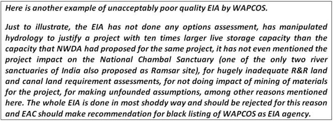
Unacceptable EIA The whole EIA is done in most shoddy way and should be rejected for this reason and EAC should make recommendation for black listing of WAPCOS as EIA agency. Just to illustrate, the EIA says MDDL stands for Maximum Draw Down level (page 1-14), has not even mentioned the project impact on the National Chambal Sanctuary (one of the only two river sanctuaries of India also proposed as Ramsar site), for hugely inadequate R&R land and canal land requirements, for not doing impact of mining of materials for the project, for not assessing the hydrological viability of the project, for making unfounded assumptions, among other reasons mentioned above.
Issue of Conflict of Interest for WAPCOS It may be noted that WAPCOS is a Ministry of Water Resources organization, and has been in the business of doing pre-feasibility, feasibility reports and Detailed Project Reports, which are necessary for the justification of the projects. This is part of the business of the organization. Such an organization has clear conflict of interest in doing an honest EIA since an honest EIA can lead to a possible answer that the project is not viable. Hence EAC should recommend that the WAPCOS should be debarred from doing any EIAs or CIAs (Cumulative Impact Assessments).
Other Issues Besides the above, a large number of issues raised by EAC in 67th meeting remain unresolved.
Þ For example, the area to be inundated by dam break needs to be listed and shown on map, which has not been done.
Þ EAC had asked: “Details of drainage network planning be included in the report.” In response, PP has attached Annex III which is just a map!
Þ EAC had asked: “75%flow series gives a total yield of catchment as 25.77 cumec-10 days in 75% dependable year. Whereas in table-5.2 the 75% dependable yield is given as 749.71 Mcm. The same needs to be corrected. Corresponding corrections at relevant sections in Volume-II, EMP report also be done”. This has not been done except an amended table
Þ Annex XIV in Additional Info on “INCOME – EXPENDITURE DETAILS OF PAFs” leaves a lot to be desired. Here, what does the figures represent in Table 1 is also not clear.
Þ Annex XV in Additional Info volume is basically a reproduction of 10.11.6 from the EIA. Incidentally, it ends by saying: “Project planner need to understand the negative impacts with sensitivity, and formulate mitigation measures appropriately; such mitigations measures that would be acceptable to the concerned population groups and that are sustainable.” The proposed project or the R&R plan are neither acceptable to the concerned population groups, nor sustainable, in any case, there is no process to achieve this.
Þ EAC had asked for more no of villages in the sample compared to 9, but the EIA consultant has refused to do this (Annex XVI and XVII in additional Info) without any convincing reason.
CONCLUSION In view of the above, we urge EAC to:
1. Reject the proposal for environmental clearance. It will be most shocking if the project gets cleared with this kind of EIA.
2. Reject the EIA, as explained above this is most shoddy EIA.
3. Reject the Public hearing; as explained above, the public hearing has not been conducted as legally required. The public hearing also need to be conducted again since the EIA is found to be so seriously inadequate and needs to be redone. In any case, with so many additions and changes to the EIA, the public hearing clearly needs to be redone.
4. Suggest black listing of WAPCOS as EIA and CIA agency. It is high time for EAC to send a signal that such shoddy EIA would not be accepted and is in violation of law.
Submission showing how the WAPCOS EIA of Mohanpura Project is Inadequate and Plagiarised
Sep 23, 2013
To,
Chairman and members,
Expert Appraisal Committee on RiverValley Projects,
Ministry of Environment and Forests,
New Delhi Subject: Serious concerns on the Mohanpura Irrigation Project on agenda for the 68th meeting of EAC of RVP
Dear Chairman and Members of the EAC-RVP,
With reference to the Mohanpura Irrigation Project on agenda for the 68th meeting of the Expert Appraisal Committee on River Valley Projects, and WAPCOS response to EAC comments (August 2013), I believe that the concerns raised by the New Delhi based SANDRP has not been addressed. The Project Proponent has also not responded satisfactorily to the queries raised by the EAC, and I outline a few of their (WAPCOS) responses below –
EAC Comment No. 16: The source of data for faunal population is to be provided. The source of secondary information may be provided if used.
EAC Comment No. 17: The avifaunal list is good but requires a lot of typographical corrections. Also some of the species such as Golden Plover and Redshank have been shown as resident although they are migratory.
EAC Comment No. 18: The list of reptiles appears deficient for this hot and dry area of central India. This needs to be updated. The information provided by WAPCOS under-represents the faunal richness of the region and is an attempt to deceive the Expert Appraisal Committee on River Valley Projects. The sources used in the EIA are old and I would like to draw you attention to more recent work from the region (attached below).
Nair, T. & Krishna, Y. C. (2013). Vertebrate fauna of the ChambalRiver Basin, with emphasis on the National Chambal Sanctuary. Journal of Threatened Taxa, 5(2): 3620–3641; doi:10.11609/JoTT.o3238.3620-41
EAC Comment No. 19: The methodology for faunal surveys has not been provided properly. The faunal part in section 4.2.2 is too brief and fails to provide any idea about the primary effort. The source of secondary information may be provided if used. The methodology outlined in Annexure-XII by WAPCOS has simply been copied from other survey reports / studies without actually conducting them. This amounts to professional dishonesty and fraud, and is another attempt to deceive the EAC-RVP.
Eg: “Direct Count: Both terrestrial and arboreal (small and large) mammals were counted during monitoring of line transect (Burnham et al. 1980) that were walked in the early and late hours of the day, and during the night using spotlight or headlights (Duckworth 1992).” is plagiarised fromhttp://fes.org.in/studies/sitamata-report-final-july.pdf?file=ZG93bmxvYWQvd3AxOS5wZGY=
“Indirect Count: Presence and relative abundance of most of the small and large mammals was evaluated using methods that rely on indirect evidence such as animal burrows/holes, dung, pellets, scats, feeding signs, tracks, nests, digging and antler thrashing.” is also plagiarised fromhttp://fes.org.in/studies/sitamata-report-final-july.pdf?file=ZG93bmxvYWQvd3AxOS5wZGY=
“Line Transect useful in determining variation in herpetofaunal populations across continuously changing environmental gradients (Jaeger, 1994). Thus, systematic searches can be used to provide data for distribution, inventory, relative abundance, density estimates, population trends, site occupancy and territory mapping.” is plagiarised fromhttp://www.outdooralabama.com/research-mgmt/State%20Wildlife%20Grants/AL_AM_Final_Report.pdf
EAC Comment No. 20: The presence/absence of Blackbuck, a Schedule-I species, may be commented upon since it is expected in the area. WAPCOS response that ‘Blackbuck is not reported in the area’ is again not true. Please refer to the press report and scientific study which show the presence of black buck from the area. Press report: http://articles.timesofindia.indiatimes.com/2013-01-05/flora-fauna/36162066_1_blackbuck-population-stray-dogs-habitat Scientific publication: Karanth, K. K., Nichols, J. D., Hines, J. E., Karanth, K. U. and Christensen, N. L. (2009), Patterns and determinants of mammal species occurrence in India. Journal of Applied Ecology, 46: 1189–1200. doi: 10.1111/j.1365-2664.2009.01710.x I believe that such a manner of plagiarism and false claims of having used scientific methods during the Environmental Impact Assessment is reason enough to reject the project and to blacklist WAPCOS. Further, the Government must initiate civil and criminal proceedings against WAPCOS for fraud, suppressing facts and providing misleading information on an issue that has serious and negative ecological and social consequences.
Draft National Policy Guidelines for Water Sharing[1]: Comments[2]
Copied below are the Comments sent by SANDRP to the Union Ministry of Water Resources in response to MWR’s invitation to send comments by July 31, 2013.
1. What is the value added by these Draft National Policy Guidelines on Water Sharing? What is the immediate reason for bring out these guidelines? The guidelines do not make this clear. This becomes particularly important as under constitution, water is a state subject and among states there is increasing suspicion that centre is trying to take over the rights of deciding about the water resources. If that is the case, as it seems (see comments below), than the guidelines also seem to violate the constitutional provisions.
2. The guidelines use the word “National Interest” at least four times, without explaining who will decide this and how. This is likely to raise suspicions among the states. This is particularly true with provisions like that in section 4.6 (c) saying, “The quantum of water exported from the surplus basin in overall national interest will not be counted as water available for sharing in that basin.” This seems to give unfettered rights to the centre to decide about inter basin transfer of water citing “national interest”.
3. If the Union Ministry of water resources is going to decide what is in National Interest than it is likely to invite risk of ridiculous and risky propositions. For example, the ministry some years ago came out with a scheme of National Projects, but most of the projects under this scheme did not have statutory clearances, or were unviable or were controversial and involved unresolved interstate issues. Thus use of such terms without clear definition and clear checks and balances is not likely to be acceptable.
4. It is pertinent to note that conflicts over river waters, whether inter-country or intra-country, invariably seem to arise only in the context of large projects. So long as the river is flowing freely without any such big projects, there is no cause for any conflict between the upper and lower riparians. As soon as any riparian State plans an intervention (dam or barrage or other diversion structure), anxiety in other riparians is triggered, and a potential for conflict arises. It would appear that large projects tend to become the foci of conflicts. This is essentially because (a) they tend to drastically alter geography and hydrological regimes, and (b) they involve issues of control, power and political relations, social justice and equity. The best course to avoid conflicts is to refrain from such interventions as far as possible, keep them minimal, give advance notice of an intended intervention to all the other riparians, provide full information, take the concerns and consent of the lower riparian into account, and refrain from causing ‘substantial harm’ or ‘significant injury’ to the lower riparian. This point has not been covered in the guidelines.
5. On similar lines, the guidelines basically take a macro view and do not seem to have a place for micro, local, bottom up process or democratic perspective.
6. The sharing should be only of what is available for sharing after the ecological functions of the river (in all its manifestation and catchments) are ensured. These would include the sustaining of wildlife, aquatic life and vegetation; the maintenance of the river regime and the capacity of the river to cope with pollution and regenerate itself; the maintenance of the micro climate; the support of the lives and livelihoods of people dependent on the river on both sides of the political or administrative border; the recharging of aquifers; the preservation of wetlands; the protection of the health of the estuary; and so on. This does not find mention in the guidelines.
7. Its very important to note here that groundwater is increasingly the main source of water for all sources and more and more areas. This is likely to remain the situation whether we like it or not. Under the circumstances, sustenance of rivers flowing all round the year with freshwater as one of the most important groundwater recharge mechanism is also important, both at intrastate as well as interstate level. This aspect should have found a key place in these guidelines.
8. An inter-State river is not a sequence of Statewise segments, it is one continuous flow, one integral whole as a hydrological/ecological system. Allocating so much of its waters to State A, so much to State B, etc, involves a segmentation – a chopping up – of the river. The ideal course would be a joint, agreed, integrated, holistic, harmonious use of its waters by all the basin States coming together. Any statement of sharing principles should begin with this recognition.
9. If a sharing becomes necessary, equitable sharing for beneficial uses must of course be the governing principle, and the Ministry’s draft says this in section 4.3.
The word ‘apportionment’ is best avoided because it suggests an imposition by a judicial or other agency. As mutual agreement is also possible, the word ‘sharing’ seems better. As contending States often argue on the basis of other principles such as ‘territorial sovereignty’ (the Harmon doctrine) or ‘prior use’ or ‘prescriptive rights’, the National Statement of Principles should not merely lay down the principle of equitable sharing but specifically rule out other principles such as those referred to above. Three, it is not enough to say ‘equitable sharing’; the words ‘for beneficial and justifiable uses’ must be added, because the sharing is not for non-use or waste.
The term ‘equitable sharing’ immediately leads to the question of what constitutes ‘equity’, and the draft has something to say about this. The Helsinki Rules enumerate a large number of criteria and leave the actual applicable criteria and the relative weights to be attached to each criterion to be determined in accordance with the circumstances of each case. These are missing here.
Thus, it is not clear how this equitable sharing will be applied and how it will get change with other principles like prior use, high economic value use, etc come in the picture. This principle has always been there, and in spite of such principles, in Maharashtra, a state with largest number of big dams, 70% of irrigation water gets used up by 2% land under sugarcane. Similarly while parts of Krishna basin is highly drought prone, over 3 billion cubic meters of water get transferred from that basin to the high rainfall area of Konkan while the downstream areas in the Krishna basin is severely drought prone. This is also applicable at interstate level as is clear from the reservoir filling methods applicable in all basins, where the upstream dams will release water only when they are full and till than downstream areas wont get any water, irrespective of if the downstream areas are in the same state or another one. So in absence of clearly defined publicly accountable mechanism to implement this principle, it is of little value.
10. Incidentally, one of the criteria, namely the ‘contribution’ of each BasinState, is a bit dicey. Can that fact give unfettered rights over that water to that state? If not what will limit those rights? This is because, the State that receives the precipitation also needs downstream state to provide drainage; it follows that by virtue of providing that crucial drainage the lower State also acquires a certain right over those waters. This factor is not mentioned here.
11. The upper riparian tends to assume a primacy of rights, and in any case has control over the waters, putting the lower riparian at a disadvantage. The upper riparian often talks in terms of ‘giving’ water to the lower riparian or ‘sparing’ water for the lower riparian. It is necessary for the Statement of Principles to make it clear that there is no hierarchy of rights; that all co-riparians have equal use-rights over the waters of the inter-State river; that the lower riparian has a right to the waters. If there is a hierarchy, than the hierarchy should be made clear and also how that hierarchy is going to be ensured in real situation.
12. One of the key issues that a statement of principles must deal with is the problem of sharing in a low-flow year. This is clearly recognised in the India-Bangladesh Ganges Water-Sharing Treaty 1996. However, the draft guidelines do not make this clear.
13. The upper riparian, in using the waters, must not cause ‘substantial harm’ (Helsinki language) or ‘significant injury’ (UN convention language) to the lower riparian. (The India-Bangladesh Ganges Treaty contains a ‘no harm to either party’ clause.) The draft guidelines must include this.
14. Under the law as it stands at present, the parties to an adjudication under the ISWD Act are the State Governments. A more inclusive approach seems desirable so as to allow water-users (agriculture, industry, citizens, etc), as well as those likely to be affected by the projects in dispute, to be heard in the adjudication process.
15. Data of all kinds needed for the purposes these guidelines (e.g. section 6.1.1) shall be freely shared by the States concerned and put in the public domain for the information of all without any restrictions on the grounds of confidentiality or secrecy.
16. Section 4.3 mentions that storage of rainwater shall not qualify as direct use of rainwater. However, there are many techniques that require local storage of rainwater and such local storage should not disqualify from being considered as direct user of rainwater. This may be modified to say that storage of water beyond a certain quantity at one place (say 1 million cubic meter) may not qualify as direct use of rainwater.
17. The guidelines are only pertaining to interstate water sharing. However, any such (non binding) guidelines should also include provisions for intra-state, inter-sectoral water sharing.
18. Section 4.8 is problematic as it does not define what “existing use” is. Is the use of water by fish, plants and nature “existing use”? Does it count? It seems the existing use is entirely anthropocentric, but in case of an ecologically embedded entity like water this may be seriously problematic. Secondly, it seems to recognise use only when done through projects approved through due process. But there is a lot of informal use of water (e.g. by tribals) that is beyond the project-generated use. Does it count? Thirdly it makes a strange distinction of preplanned use. Do we have well documented and well recognised pre plan uses of water? Fourthly, the use of phrase “Every effort shall be made to protect the existing utilization” creates serious doubts as it gives an escape route that nothing is sacrosanct.
19. Section 4.9.1 also raises serious suspicions since it says even where an existing interstate agreement has approval of all the basin states, it may still not be good enough before “national interests”. This is bound to raise suspicion of all the states.
20. Section 4.10.2 is also likely to raise suspicions as it reads: “In the process of water sharing/distribution, in consultation with the co-basin States, the Centre would take care of the water sharing/distributions required in the national interest… Any State affected adversely due to such sharing/distribution would be adequately compensated by alternative means.” This seems to give rights to centre that so far belongs to the state. As far as the interests of the ecology and environmental flows are concerned, centre has the powers under Environment Protection Act, 1986 and do not have to resort to such seemingly extra constitutional guidelines.
21. The presence of section 4.12 on interlinking further raises the suspicion that this whole effort is geared towards pushing such projects. This should have had no place in these guidelines.
22. In section 5.1b there should have been explicit mention of groundwater use and climate change implications on water use and availability.
23. In section 5.4b(i) it is not clear what is the basis for review after 40 years.
24. The whole guidelines have no place for people, and also has no value for transparency, accountability or participatory processes.
25. Conclusion This exercise may be redone with more open ended terms of reference and holistic way of considering water in nature and with greater faith in the people and democratic processes.
The Ministry should not rush through this. It should give more time for feedback, take up extensive consultation and make the draft available in regional languages.