Bihar · Dams · Ganga · Himalayas · Interlinking of RIvers

Dams, Fish and Fishing Communities of the Ganga: Glimpses of the Gangetic Fisheries Primer

Some highlights from SANDRP’s latest Publication on Riverine Fisheries of the Ganga

The government is discussing Ganga not only as ‘Ganga Mata’, but also as a ‘navigational corridor’ with plans to build barrages after every 100 kilometers with funding from World Bank. At her origin, hundreds of hydropower dams are changing the ecological character of the Ganga. However, as a rich ecosystem, the Ganga also supports  about 10-13 million riverine fisherfolk and about 300 freshwater fish species! Riverine fisheries have been a blind spot in Independent India, despite the fact that they provide nutritional and livelihood security to millions of people.In the post independence water management discourse, river has been equated to water and water to irrigation, water supply, and hydro power. The profound impacts of irrigation, water supply and hydropower dams on sectors like riverine fisheries have been entirely ignored.

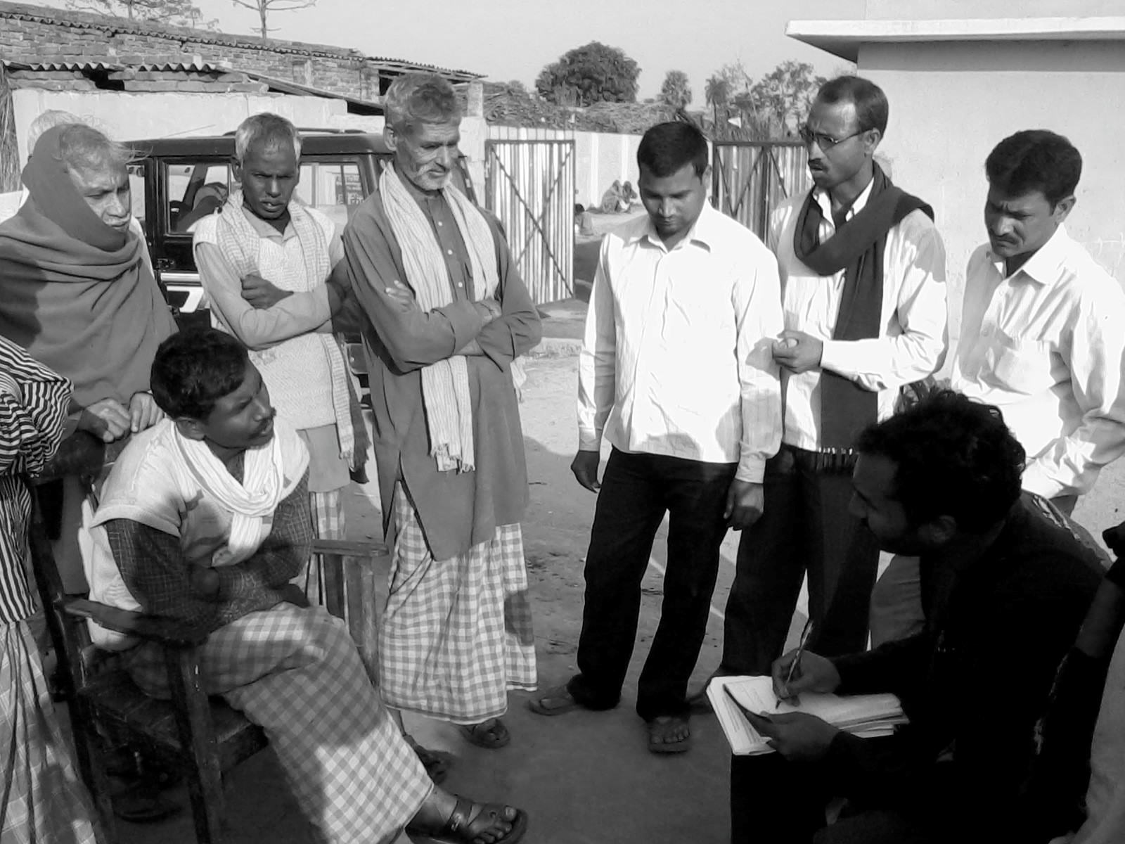
Nachiket Kelkar looks at the status of riverine fisheries and fisher communities in the Gangetic Basin of India and highlights the devastating impacts of dams, barrages and water abstractions on this. Nachiket’s study on Gangetic Fisheries is based on long term engagement with fisher communities in the basin as well as robust scientific studies.

SANDRP has published this work in the form of a Primer which will soon be available online. What follows are some glimpses from the Primer. Please write to us if you are interested in receiving a full soft copy of the Primer.

~~~~~~~~~~~~~~~~~~~~~~~~~~~~~~~~~~~~~~~~~~~~~~~~~~~~~~~~~~~~

GangeticFisheries1

Riverine fisheries of the Gangetic basin support one of the largest fishing populations of the world. However, its fish resources are rapidly declining due to large dams, barrages and hydropower projects, severely altered river flows, fragmentation of hydrological connectivity between rivers and wetlands, alarming levels of pollution, riverfront encroachment, rampant sand mining and unregulated overexploitation of fish resources.

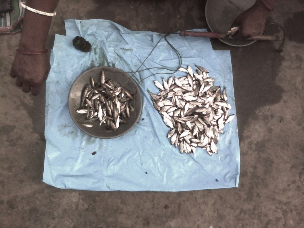
Across its range, the fisheries show indications of economic unviability and ecological collapse, with violent social conflicts as an outcome of the contest over scarce and declining resources as well as politics and access. A major factor behind the serious fisheries-related problems is severe alteration of river flow volume and seasonal dynamics by large dams, barrages and hydropower projects. The state of river fisheries directly indicates the declining biophysical, ecological and social integrity of the river basin. The existing in-river fisheries contribute merely about 10% of the overall inland fish production. Even this production is highly unsustainable today and has all the indicators of serious levels of overfishing. For instance, river fisheries in Bihar now even glean small-sized fish fry for markets in northern West Bengal (Siliguri) and Assam, where eating small fish is a delicacy (F.pers.comm).

To understand the situation in Gangetic Basin clearly, a detailed, large-scale interview survey was conducted by the author in 2012 across 372 fishers in 59 fisher groups spread over 17 rivers in 5 north Indian states. The survey objective was to document perceptions of traditional fishing communities about issues and problems in fishing in the Gangetic basin. Of the respondents, c. 90% singled out “large dams and poor river flows” as the main causes for a near-total decline in fisheries and fish resources over the past 4 decades. About 90% people mentioned low water availability and stoppage of fish migratory routes by large dams as the main cause for fish declines. Almost 45% (from eastern and northern UP, and Bihar) singled out the Farakka barrage as the main problem.

The Sone River in the dry season. Poor river flows released by dams and barrages have serious implications on fisher livelihoods. Photo: © Subhasis Dey.

The Canvas of Gangetic River Fisheries
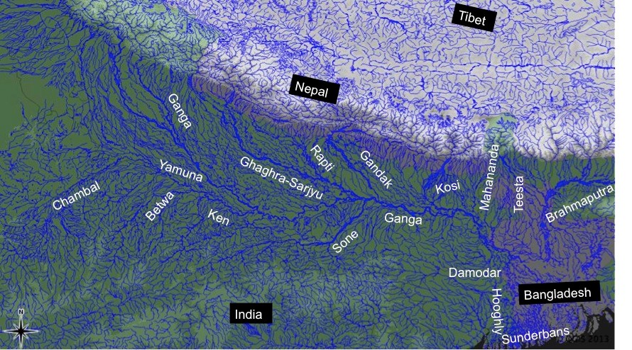
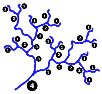
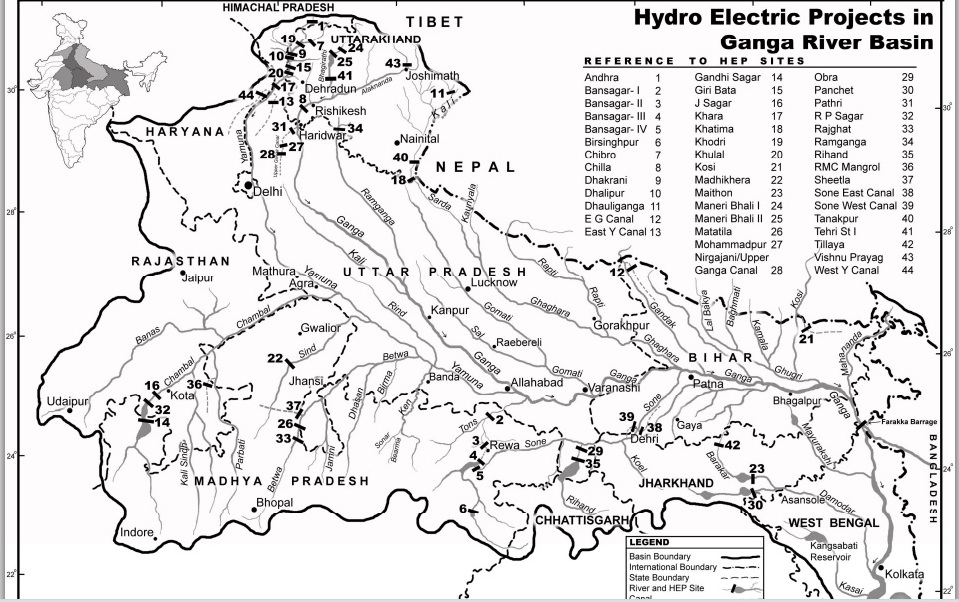
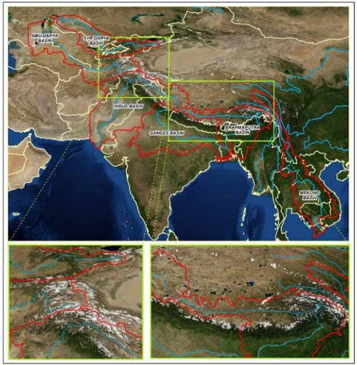
The Ganga  River, from her headwaters to the delta, along with hundreds of her tributaries drains an area of approx. 0.9_1 million km2 across northern and eastern India, flowing through 10 states in India and also in Nepal and Bangladesh. These rivers form one of the largest alluvial mega-fan regions of the world, and deliver huge quantities of sediment from the Himalayas to the northern Indian plains and to the Bay of Bengal in the Indian Ocean. The Gangetic floodplains shape not only landforms but also complex human cultures that attempt to stabilize themselves and adapt to the constantly changing riverine forces. Biodiversity, hydrology, geomorphology and social dynamics influence each other through constant interaction and multiple feedback mechanisms.

The major rivers of the Gangetic Basin (Based on ‘hydro1k-rivers-Asia.dbf’).

The dynamic balance of these factors triggers opportunities for spawning, reproduction, population dynamics and viability, migration and movement of freshwater species, including fishes, river dolphins, otters, crocodilians, turtles, invertebrates as well as terrestrial biodiversity.

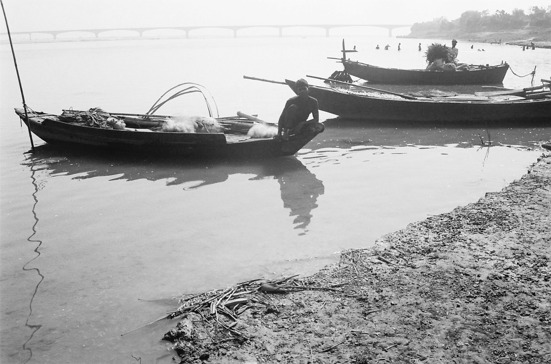
In floodplain rivers, as floodwaters recede post-monsoon, fishers record the highest catches in October and November, as large post-breeding and migrating adult fishes (e.g. major carps, clupeids, mullet) become catchable. Winters, from December to early February, generally record low catches because many fish show slowed behavior and limited movement. But in spring fisheries of minor carps and catfishes record high production. With water levels reducing, fishes become more concentrated in specific river habitats like deep pools, where they are easy to fish. Summer fish catch biomass is also reasonably good due to the overall low water availability.

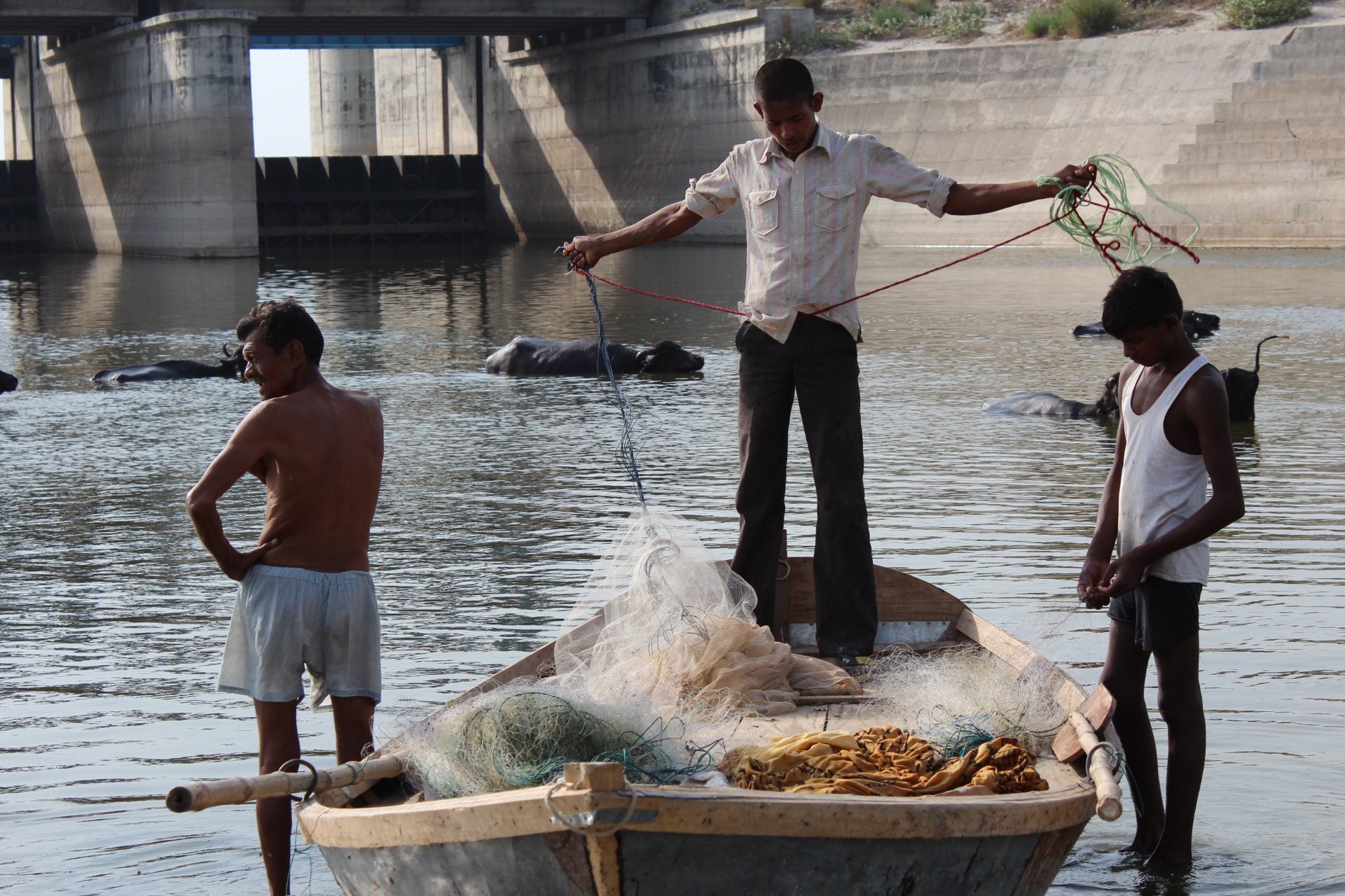
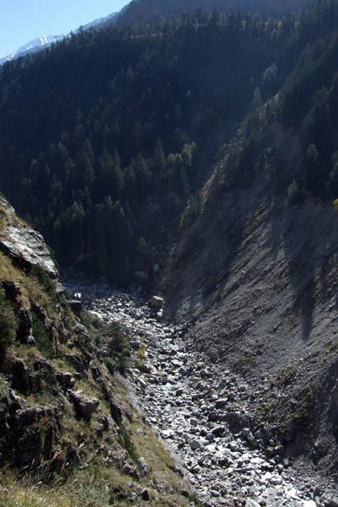
In the Gangetic basin, fisheries are practiced in a range of diverse freshwater habitats including natural and man-made, lentic (stagnant water) and lotic (flowing water) ecosystems. Natural freshwater areas include large floodplain rivers, non-perennial rivers, perennial and seasonal streams, cold-water rivers and streams, glacial lakes, estuaries, tidal rivers, floodplain wetlands, oxbow lakes, grassland swamps and marshes. Manmade habitats include dug or built-up wetlands, ponds, man-made reservoirs, dam reservoirs and canals. To the fisher, flow velocity, depth profile, substrate type, vegetation structure, current patterns and habitat stability are key indicators for fishing effort allocation and logistical decisions.

Fish Diversity in the Gangetic Basin
The overall species pool of the Gangetic fish assemblage is estimated at around 300 species (53+ families, 150+ genera; 250 species). The floodplain fisheries are dominated by major and minor carps (Cyprinidae), catfishes (Siluriformes: 6-7 families), Clupeidae, Notopteridae and a mix of many other families. Major carps and the Clupeid fish, Hilsa (Tenualosa ilisha) and some large catfishes form the most valued catches across most parts of the Gangetic floodplains.
Major carps, the most preferred freshwater food fishes, include species like Catla, Rohu, Mrigal, Mahseer etc. exhibit potamodromous (along freshwater upstream-downstream gradients) migration. Though these fishes have suffered serious declines due to overfishing, pollution and dams, they have been mass-produced through artificial rearing in pond aquaculture. Farmed large carps form the major proportion of fish eaten anywhere in India today. In wild fisheries, catfishes come lower in the preference order, but with the decline of carps, medium and small catfishes have become the main fishing targets. Further, as most catfishes are sedentary and do not show long-distance movements, the fisheries have completely switched from carp- to catfish-targeting fisheries. Other deep-bodied, highly sought after fishes include the Chitala and Notopterus, or the featherfishes, and mullet.

Various fish species in Ganga Basin. Refer to the Primer for more information.

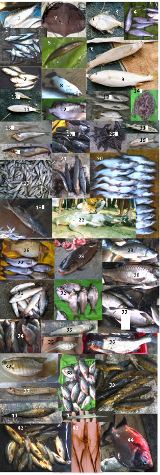
The estuarine fishery in the Hooghly and Sunderbans tidal rivers in West Bengal is dominated by shellfish (prawns, mud crabs and shrimp), Clupeidae and Engraulidae, Sciaenidae, catfishes of the Ariidae and a far more diverse set of families compared to truly inland fisheries. Other important components of the commercial fisheries include 5-6 species of shellfishes (mainly prawn and shrimp).

Coldwater fisheries specialize on large-bodied, rapids-loving potamodromous migrant fishes such as Mahseer and Snow Trout. These fishes are of high commercial importance and are in high demand by professional sport fishers and anglers, apart from being highly prized as food locally. Mahseer in particular, have recently led to the opening of new markets of luxury wildlife tourism that is based on angling and recreation in the Western Himalaya.

Dam reservoir fisheries are almost entirely based on managed stocking and breeding of commercial fishes in hatcheries, of major carps Catla, Rohu and Mrigal, catfishes like Pangasiodon, and minor catfishes. The state of river fisheries in the Gangetic basin has been affected over the last few decades by several threats described in the next section.

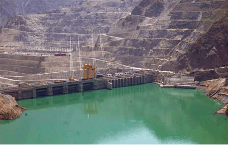
Dams and Riverine Fisheries in India Fisheries across India have been severely affected by dams, flow regulation and associated human impacts, which have substantially altered ecological requirements of fisheries and biodiversity together. If one clinically investigated the fisheries’ decline, they would find it to coincide with the period of maximum dam building (1970s-80s) in India. Most commercially valuable fish species, especially major carps and Hilsa, have shown population-level collapse and even commercial extinction over large inland waters. Reduction in harvested fish size-class distributions, a classical indicator of overexploitation by fisheries, points to poor fish recruitment and adult survival, which may be further brought down by flow regulation by dams. Dams have acted as the major factor of disruption by blocking migratory routes of upriver or estuarine spawning fishes such as Hilsa and Anguilla eels. Dams have also caused loss of genetic connectivity between fish populations, most notably seen in major carp stocks. Erratic water releases, nutrient and sediment trapping behind dams and barrages, failure of breeding in carp and catfish species due to siltation, erosion, poor water availability, modified thermal regimes required for breeding (increase in temperatures due to low river depth/flow), and exceptional levels of hazardous pollution (again, magnified due to the poor flows reducing dilution capacity of river water), are other fallouts that adversely affect fisheries. The fact that there is just not enough water in the river must form the bottom line of any causal investigation of riverine fisheries. Lack of appropriate policy measures and pollution receive dominant mention as threats to fisheries by government research agencies, but they are mere outcomes of much larger shifted baselines because of dams. Dams, barrages and hydropower projects through flow regulation have increased uncertainty about fishing and driven fishing to desperate levels: fishers often resort to destructive practices, or even worse, exit the fishery altogether. Such exit does not solve the problem of existing fisher folk: water is critical to sustaining not just fisheries but the river and the people dependent on it. Detailed understanding of the lives of fishing communities of the Ganges is therefore critical.

Ganga made completely dry at Haridwar by the Bhimgouda barrage Photo: SANDRP.

Fisher communities in Ganga: Around 10-13 million people in the Gangetic floodplains are estimated to be dependent on fish resources for their livelihoods, directly or indirectly. However, accurate estimates of active traditional and non-traditional fisher populations are still wanting. It is important for any discussion on fishing communities to clearly separate traditional fishing communities from ‘non-traditional fishers’, who may be practically from any other local community and with the possession of other livelihood options, but also opportunistic fishing, due to unrestricted access to imported nets and gear available in markets to anyone. Traditional fishing communities were always the craftsmen of their own nets and gear, and also possess remarkable ecological knowledge about rivers, fish and biodiversity, their breeding biology, ecology, seasonality, and distribution. Of course, with the degradation of fisheries throughout the Gangetic plains, the traditional knowledge and practices of fishing are eroding fast. Hence such knowledge needs to be documented well, especially from old fishers with whom it still persists, to identify historical baselines of river fisheries with a different, past ecological reference (pers.obs.; F.pers.comm).
Traditional fishing communities today form a highly marginalized, politically unorganized and socio-economically impoverished people. Caste discriminations and political history form the chief reasons for their poverty and subjugation over centuries of fishworking. But the present condition of rivers does not seem to offer hope to any improvement in their economic position unless and until there is collective voicing of their concerns, especially against large-scale water engineering projects that threaten their livelihoods.

Author in discussions with fishers

Their livelihoods, one may argue, confined them to the river’s water, albeit the fact that they never owned the waters legally. However, they always have stated cultural claims of temporally confined territory, following their foraging preferences and site usage. But depending on the nature of the river’s hydrological dynamics, there may be variable maintenance of fixed ‘territories’ by fishers adopting a roving mode of fishing, and neither legal nor cultural claims can be reconciled to a level that the conflicting parties can reach mutually. With regards to their economic viability and status, a large proportion of the traditional fishworkers fall Below the Poverty Line (BPL), and are recorded as Economically Backward Castes, and also have been assigned the status of Scheduled Castes. Annual incomes from fishing alone, according to the few estimates available, range from INR 25,000/- to INR 50,000/- (pers.obs., F.pers.comm.).

Large dams, flow regulation and Gangetic basin fisheries : The singular key problem of fisheries today is that it lacks water in the dry-season, because of flow regulation by dams, barrages and hydropower projects. More water flow releases are needed for the protection of riverine fisheries in the Gangetic basin. Widespread river habitat degradation, industrial, agricultural and domestic pollution, altered flows and modification of sediment and nutrient fluxes by dam projects, and resource overexploitation (by fisheries, agriculture or industry) have had major consequences for the unique biodiversity and fisheries of floodplain rivers across Asia. Obstruction and fragmentation of river flow, habitat destruction, accelerated erosion and siltation, long-distance water diversions (involving huge amount of transmission losses and waste) and poor flow releases are the major direct threats of dam-canal systems in the Gangetic plains.

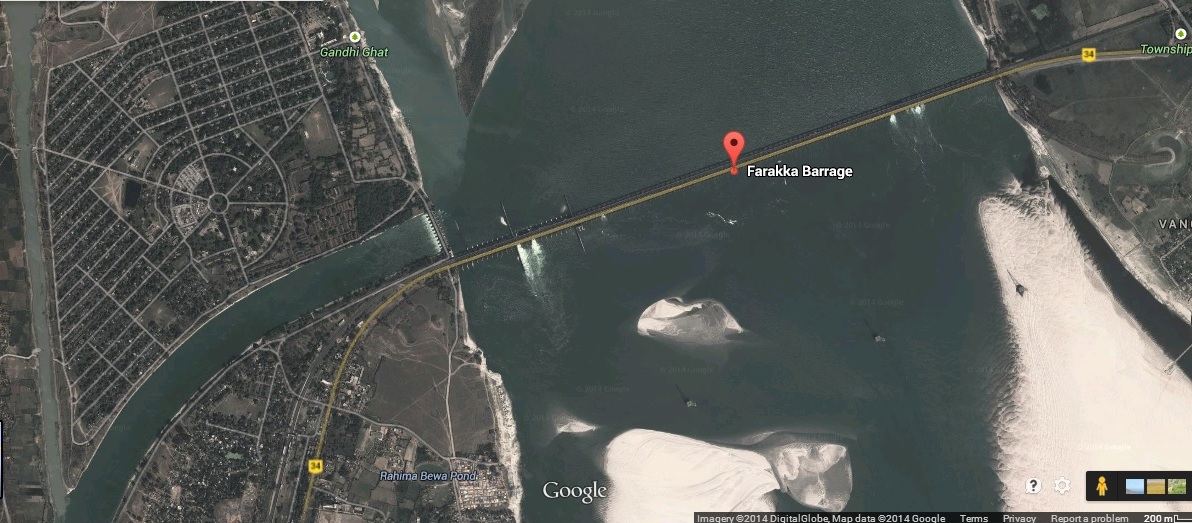
Flow volume problems: Lower-than-minimum flows have been consistently recorded across the Ganga, Yamuna, Chambal, Kosi, Sone, Ken, Betwa, Ghaghra and Gandak rivers. Along with these large rivers, almost all others (Rapti, Baghmati, Mahananda, Teesta, Kamla, Burhi Gandak, Punpun, Gomti and others) have been highly regulated64,69. The reduction of freshwater discharge reaching the Sunderbans because of the Farakka barrage has led to high degree saline ingress throughout the estuary, causing die-offs of considerably large tracts of mangroves and aquatic vegetation, as well as severe losses to the upstream fishery. Downstream, fishing practices suited to brackish and fresh waters now have to adapt to saline intrusion into the estuary’s waters. Globally, fragmentation and flow regulation have caused the most severe impacts through drastic alterations to riverine biota and ecology. Low flows and fragmented connectivity of river channels lead inevitably to fish population declines and breeding failure. Over time, dams have probably led to genetic isolation of fish populations as well as river dolphin / crocodile populations, destruction of fish breeding habitats and spawning triggers and loss of valuable wild fish germplasm. These losses are so large in their ecological value and opportunity costs that they cannot be recovered with artificial fish culture techniques or hatcheries.

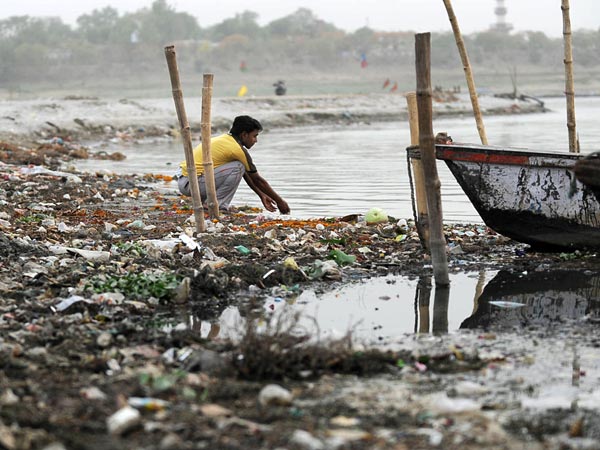
Aggravation of pollution effects: The Ganges basin is one of the most polluted large river basins in Asia, especially with regards to domestic sewage and agricultural runoff. Poor flows reduce the dilution and self-purification capacity of river water to reduce concentration of pollutants and local impacts on fishes. . Agricultural fertilizers (organophosphates, organochlorines, nitrates etc.), heavy metal pollution from industrial effluents, thermal power plants, oil refineries, distilleries and tanneries, and nitrogen-rich sewage, waste-water and non-biodegradable substances such as plastics, mercury, radioactive compounds and hospital wastes can cause fish kills or even worse, lead to high levels of toxicity in tissues. Pollution problems are especially acute in highly regulated river reaches, especially around Delhi (Yamuna River), and the Gomti at Lucknow, Yamuna until Panchnada in UP and Ganga River at Kanpur, Allahabad, Varanasi, Patna, Barauni, Bhagalpur and Farakka.

Polluted Ganga at Allahabad Photo: National Geographic

Siltation in dam reservoirs and barrage gates: Excessive siltation in the Ghaghra barrage has led to, as per local fishers, breeding failure in Labeo angra (Ghewri), a preferred spring-fisheries target in the region. The fishers claimed that over the past 5 years they have not captured a single fish with eggs inside it, and also added that catches have plummeted heavily (F.pers.comm). Siltation of gravel/sediment in reservoir or storage zones is a problem of huge magnitude for fisheries, especially through breeding failure. Accumulated silt in reservoirs is estimated to be so high (in tens of meters height) that it cannot even be easily flushed out, and leads to nearly 60-90% reductions in sediment fluxes of rivers in monsoon and non-monsooon seasons. Siltation adds to obstruction of flow release through barrage gates. In the Farakka barrage, sediment load accumulation is leading to breakage of gates every year, adding to maintenance costs.

Habitat destruction and alteration of erosion-deposition dynamics: Soil erosion by erratic and sudden releases before floods can potentially lead to alteration and destruction of fish breeding habitats and stock depression. Changes in depth and flow velocity lead to fish not being able to receive natural physiological cues for movement and spawning that are otherwise provided by variability in discharge. Flow alteration also alters hydrological connectivity and sediment transport with wetlands and confluence channels during flooding. As a result these productive breeding habitats often become unavailable for catfishes and carps. These factors together become a problem for pre-settlement fish juveniles and recruits, which move into the main channels.

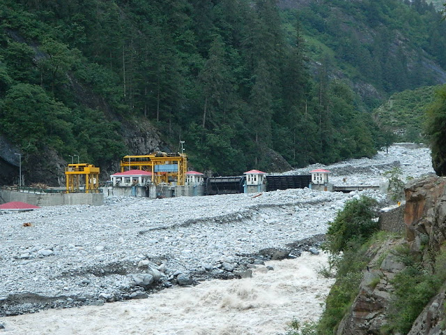
Threats to cold-water and foothills fisheries from Hydropower Dams: Overall, despite their projected low impact situation, hydropower projects can have serious large-scale effects on mountain streams as well as rivers downstream. Globally, despite mitigation measures in hydropower constructions, fish migration and development have largely been deemed as failures. In India, hydropower projects, especially run-of-river projects in higher altitudes, often have disastrous effects on natural thermal regimes, cause sediment blockages and perturb natural flow variability at diurnal timescales through releases varying across several orders of magnitude. These changes severely affect not just breeding and migration in higher-altitude cold-water fisheries of snow trout and Mahseer in Himachal, Sikkim and Uttarakhand, but also downstream fisheries of catfish and carps in the foothills and plains due to altered flows. Their cumulative downstream impact can also potentially risk fisheries-based uses of river water without being exposed to the risk of sudden flow releases every day.

Globally, through extreme perturbation of natural flow dynamics, dams have homogenized and altered many crucial river-floodplain processes, and have had disastrous impacts on biodiversity and fisheries. There is an urgent need to ensure ecologically necessary, adequate and natural flow regimes in all rivers of the Gangetic basin. The current water scarcity is so severe that projects such as river interlinking, apart from their ridiculous proposed costs, are simply impossible to conceive of, water itself being the limitation. There is no doubt that further water developments will prove disastrous for a whole section of people and their livelihoods, and must be scrapped. Rivers that need urgent attention in this respect are the Chambal, Yamuna, Ken, Betwa, Alaknanda, Bhagirathi, Mandakini, Sone, Damodar, the Ganges at Farakka and Allahabad, Sharada, Ghaghra and all other rivers especially in Uttar Pradesh, Uttarakhand, Madhya Pradesh and Bihar0. Run-of-river hydropower projects, flow diversions and links, pumped irrigation, embankments, agricultural intensification, groundwater depletion and sand mining are highly destructive threats that will affect not just fisheries but the whole social fabric of river users in the near future.

Despite the demonstrated folly of not allowing rivers to flow from headwaters to estuaries and deltas, engineers, technocrats and politicians talk of “rivers flowing wastefully into the sea”. This statement would imply that the thousands of species and millions of fisher livelihoods that need flowing water in rivers are of no value to the state policy on water resource development. Such statements are ignoring important societal needs and hence are evidently irresponsible.

No post dam-construction compensation schemes exist for fishers, who may lose their entire livelihood because of flow-regulation and loss of hydrological connectivity due to dams. Downstream fisher populations must be ideally compensated for the lost fishing catch and livelihood opportunity, but in general there has been scant attention towards the communities’ livelihoods (F.pers.comm). Downstream water allocations through on-ground consultations with fisher communities are urgently needed (F.pers.comm). In India, water resources development is so strongly irrigation-focused (and now strongly focused on industry and hydropower), that, in comparison, riverine fisheries are not even acknowledged as legitimate and in need of conservation and livelihood protection. These biases mean that only pond aquaculture receives any attention. If river conservation and development groups can actively work with fishing communities in order to develop an informed and aware constituency or interest group, fishers will gain political voice in making negotiations about water availability in river basins.

Fisherfolk of Ganga Photo: Gangapedia

Fisheries incur ‘colossal losses’ every season due to irregularities in dam operations, and always fall severely short of demand. But now, through the boom of artificially managed pond aquaculture and wetland fishing especially in Andhra Pradesh and West Bengal, the nature of supply itself has radically changedThis boom has contributed to India becoming one of the largest producers of inland freshwater fish in the world. But such ranking hides a lot of miserable facts about river degradation. Although net production shows increases, the collapse of river fisheries that still support millions of poor people who don’t get access to aquaculture, get totally ignored under such swamping. This is why farmed fish in fish hatcheries can barely replace riverine fisheries despite the fact that they have cornered the attention of fisheries development.

The failure of river fisheries has led to large-scale outmigration for labour from the Indo-Gangetic plains (F.pers.comm.). This might be a significant contributor to the magnitude of labour-related migrations from the Gangetic plains, which has been a rising exodus. Today, fisher folk from Uttar Pradesh, Bihar and Bengal provide a large proportion (20-40%) of construction and manual labor force across India (F.pers.comm). Others who stay behind have to take to menial jobs such as rickshaw-pullers or servants (F.pers.comm; pers.obs). Some are forced to take to crime to be able to feed themselves and their families. These factors can weaken the social resilience of production systems and create poverty, disparity and community breakdown. It has been argued that ethnic conflicts between local Indian populations and illegally immigrated Bangladeshi refugees are linked to poor water releases from the Farakka barrage in West Bengal, to downstream floodplain reaches in Bangladesh.

Mitigation measures like Fish ladders and hatcheries
There is little existing research on the construction design, functioning and efficiency of fish ladders in tropical and subtropical large floodplain rivers. Across the tropics, monitoring studies on fish ladders do not show positive results. A handful of barrages in India have constructed fish ladders, but owing to numerous problems they have been largely a failure. These problems are all related to the extremely low discharge rates from the dams – as there is simply not enough water volume allocated for migrating fishes, which therefore cannot access the ladders and fish lifts. Other problems are linked to siltation in reservoirs and turbulence of flows near the fish passages. For instance, the Farakka fish lifts do not seem to have been of any help due to the extremely low outflow of the Ganga River from it, and the commercial extinction of the Hilsa fisheries both upstream and downstream is clear with an estimated 99.9% decline. Fish passes constructed at barrages on the Yamuna River (Hathnikund barrage) and the Ganga barrage at Haridwar have been monitored by CIFRI and the results suggest that they have had very low success for migration of cold-water species like the Golden Mahseer Tor putitora. Similar structures on the Beas River and Mahanadi River (Salandi dam, Orissa) have found to be ineffective in buffering the adverse impacts on fisheries production in these rivers. India has dominantly followed reservoir hatcheries development, and therefore consideration for effective fish ladders has always been low priority. However, as we have seen, hatcheries themselves bring about several problems for native fish populations – and are not an ecologically viable solution, despite being economically profitable to certain interests. Given the poor success of existing fish passages, it is important to consider modern designs in existing and proposed dams that are suited to the ecology of our own fishes. A whole body of interdisciplinary research – spanning engineering and ecology, is needed to address the significant gaps in our understanding of making fish passages work. We need to monitor existing examples well to assess reasons for their failure. Again, just the act of allowing higher dry-season flows and timely adequate releases in the river could be a far more effective strategy for fisheries improvement than other intensive technology-driven practices to enhance fisheries production (F.pers.comm)

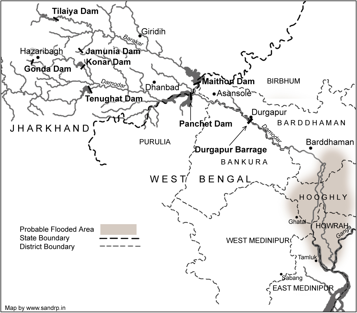
River restoration and alternative livelihoods: Given the current state of riverine fisheries, there is an urgent need to consider possibilities for large-scale ecological restoration of rivers by modifying dam operations and improving ecological flows. Alongside restoration, it is crucial to consider alternative livelihoods to fishers, which regard their traditional knowledge and provide them with clearly defined user rights and responsibilities over management of wild-caught or cultured fish resources. Ecological restoration of all major and minor rivers in India needs to be undertaken urgently, to ensure ecologically adequate, naturally timed flow releases, consistent dry-season flow regimes, hydro-geomorphological habitat maintenance, flood maintenance and reduction in pollution. Dam re-operations to ensure adequate flows and variability in river discharge remain a neglected aspect of river management in most regions today. Flow restoration can lead to improved health, numbers and availability of native commercial carps and preponderance of larger fish sizes through improved juvenile recruitment, along with other advantages to surface hydrology and local groundwater availability. Large-scale scientific research and monitoring programs must be instituted to study the response of inland wild-capture fisheries and take further steps to mitigate local threats. Restoration also needs to involve stringent restrictions on release of untreated domestic and industrial effluent, especially in urban belts such as Kanpur, the National Capital Region of Delhi, Allahabad-Varanasi, Mathura-Agra, Lucknow in Uttar Pradesh; Patna, Barauni in Bihar and the Durgapur and Kolkata regions in West Bengal. Strict restrictions are needed on sand-mining, riverfront encroachment and embankment construction, especially in the Chambal, Ghaghra, Gandak, Baghmati, Rapti and Kosi Rivers. In this regard, more judicial interventions, such as seen recently in the case of sand-mining closures from river beds based on a review by the National Green Tribunal, are critical in reducing wanton and unregulated destruction of riverfronts, when implemented effectively. In terms of reducing the most direct impacts, there is a need to regulate fishing pressure and completely curb destructive fishing practices like dynamiting, use of mosquito-nets, beach seines, and gillnets below allowable mesh-sizes, poisoning, use of long-lines etc. Traditional fishers must be involved directly in monitoring and banning the use of destructive practices by the government monitoring agencies.

Finally, the quest for sustaining fisheries in the Ganga River basin in the long-term will require rethinking of current dominant paradigms to move towards ecological restoration of rivers, their biodiversity, as well as socially just, rights-based and equitable socio-political restoration of traditional fisher communities and fisheries management systems.

-Nachiket Kelkar

Ashoka Trust for Research in Ecology and the Environment, Srirampura Royal Enclave, Jakkur, Bangalore 560064, India. (The views expressed are of the author and do not belong to the institution where the author currently works)

Member, IUCN Cetacean Specialist Group, IUCN, Gland, Switzerland.

Email: rainmaker.nsk@gmail.com, nachiket.kelkar@atree.org


Twelve-point recommendation from traditional fisher communities for sustaining riverine fisheries and livelihoods in the Gangetic basin.

Rank Need Recommendations
1 Water Provide enough water, adequate natural flows in all rivers. Allow fish movements upriver, currently blocked by large dams and barrages. STOP new dams and mindless, high-cost, destructive and unsustainable engineering projects such as river interlinking.
2 Ban on destructive fishing practices Curb destructive practices of fishing, especially mosquito-netting, poisoning, dynamite-fishing, trawling and beach-seine netting everywhere.
3 Poverty alleviation and social security Fishers are in need of government dole or loans, technical know-how, permits and I-cards, housing, education and displacement packages. It is alleged that these benefits are hardly reaching them, although the allocations of funds reach farmers easily. Fishers need government security from criminals / mafia / anti-social elements / pirates that harass them and grab fish catch.
5 Define fisher rights and responsibilities Clearly define fishing use and access rights across all riverscapes, provide clear guidelines on multi-objective management of fisheries amidst other economic activities
6 Reduce pollution and mass fish-kills Urgent need to reduce the presently excessive river pollution, especially industrial but also domestic wastes.
7 Alternative livelihoods River fisheries are currently in a state of ecosystem-level decline or collapse. Trash fishes have become the most common catch, replacing many commercially viable carps and catfishes. People require alternative livelihoods in situ, to check problems related to migration and exodus to work as construction laborers or rickshaw-pullers. Community-based, cooperative pond carp-culture fisheries seem highly promising. Other alternative livelihoods include working with river management authorities, conservation agencies, ecotourism, agriculture etc.
8 Fishery co-operatives Focus on community-based management of river fisheries and help it develop in an ecologically friendly and sustainable manner. Replace the systems of private contracts and free-for-all fishing by power-equitable, social dignified resource-sharing arrangements
9 Ensure compliance of fishers towards biodiversity conservation and monitoring Needs to be ensured through continued monitoring of fishing activity and behavior, including by-catch or hunting of species. This will help safeguard endangered wild species such as gharial, turtles, river dolphins, birds etc. This can also help the spread of exotic food fishes that are rapidly invading our rivers (the worst examples are Tilapia species, Chinese and Common Carps, and more recently, Red-bellied Piranha.
10 Use of Food Security Act, Rural Labor Programs Can facilitate daily incomes by which fisheries losses could be offset; while also providing a solid community-level incentive to regulate and monitor fishing.
11 Restoration of native riverine fish communities Very important given the huge decline in native carp species of high commercial value. Fisheries need to protected not only by revival of stocks, facilitating better fish recruitment, but also by protecting fish breeding habitats from
12 Adaptive management of water tenure in fishing areas Owing to natural uncertainty linked to flow regimes and channel course changes, new flexible systems of tenure in fisheries are required. Such systems would fit in well with providing a clear definition to fishing rights in any riverine stretch.
Delhi · Ganga · Interlinking of RIvers

Rivers and Water in Union Budget 2014-15

In the first annual budget (for the year 2014-15) presented by the new NDA government at the centre on July 10, 2014, it is generally bad news for Ganga and other rivers. Below we have given various provisions on water and river from the budget speech of the Finance Minister Shri Arun Jaitley. Mr Jaitley said in his speech: “In the first Budget of this NDA government that I am presenting before the august House, my aim is to lay down a broad policy indicator of the direction in which we wish to take this country.” The broad policy indicators on rivers do not seem to be any good news for the rivers of the country.

RIVERS FM said, “Rivers form the lifeline of our country. They provide water not only for producing food for the multitudes but also drinking water.” This shows the limited understanding of rivers that the government has. Rivers provides so much more than water. The FM do not seem to have any good news for this lifeline as the budget has several proposals that will harm and destroy the rivers.

River Linking The PIB wrongly claims, “The Budget also contains the first ever effort to link the rivers across the country.” A sum of Rs. 100 crore in the current Budget to expedite the preparation of Detailed Project Reports has been set aside. This is waste of public money. In addition to this, there is a huge allocation for the annual budget for NWDA, whose only mandate is studies for river linking. It is existing for 22 years, but has not produced a single document that will pass independent public scrutiny, and NWDA is afraid to put any document in public domain. Why is the government spending money on such fruitless exercise?

GANGA: Integrated Ganga Conservation Mission The Finance Minister, Shri Arun Jaitley said, “I propose to set up Integrated Ganga Conservation Mission called “Namami Gange” and set aside a sum of Rs 2,037 crores for this purpose.” Shri Jaitley said that the Mission is being launched because a substantial amount of money has been spent in the conservation and improvement of the river Ganga but the efforts have not yielded desired results because of the lack of concerted effort by all the stakeholders. This is admission of even NDA’s failure, since they were in power for at least six years and have not been able to make a dent in the state of the river. They should learn from that experience before jumping into such missions.

This raises a lot of unanswered questions: There is already an existing National Mission for Clean Ganga and if this new mission will be in addition to the old one or if the old one will be abolished? What is new in the new mission? Strangely, the FM did not use the work Ganga Rejuvenation, the charge that Ms Uma Bharti has been given. Does this indicate something is amiss here?

Riverfront Development “The Finance Minister has also set aside a sum of Rs. 100 crore for Ghat development and beautification of river front at Kedarnath, Haridwar, Kanpur, Varanasi, Allahabad, Patna and Delhi in the current financial year since Riverfronts and Ghats are not only places of rich historical heritage but many of these are also sacred.”

The trouble is, this could spell disaster for the river and the cities where such development is planned, if this is going to happen on the lines of Sabarmati river front development. This is because in case of Sabarmati, the Riverfront development meant encroachment of over 200 ha of riverbed. If this is followed the river’s carrying capacity will be reduced. In changing climate, rivers need more and not less carrying capacity as the events of July 2005 in Mumbai, of August 2006 in Surat & recent years in Delhi have indicated. During Uttarakhand disaster of June 2013 the buildings that we saw collapsing were all standing on the riverbeds. That should be a warning for any riverfront development that would encroach on the riverbed.

NRI Fund for Ganga To harness the enthusiasm of the NRI Community to contribute towards the conservation of the river Ganga, an NRI Fund for Ganga will be set up which will finance special projects, the Finance Minister added.

“A project on the river Ganga called ‘Jal Marg Vikas’ (National Waterways-I) will be developed between Allahabad and Haldia to cover a distance of 1620 kms, which will enable commercial navigation of at least 1500 tonne vessels. The project will be completed over a period of six years at an estimated cost of Rs 4,200 crore.”

Watershed Development To give an added impetus to watershed development in the country, a new programme called “Neeranchal” will be launched with an initial outlay of Rs 2,142 crore in the current financial year. This could be a positive move, but we have to await the details. It is also not clear if this is in addition to the ongoing watershed development or in place of it.

Rural Drinking Water For providing safe drinking water, Rs 3600 crore has been earmarked under National Rural Drinking Water Programme in approximately 20,000 habitations affected with arsenic, fluoride, heavy/toxic elements, pesticides/fertilizers through community water purification plants in next 3 years, the Finance Minister added.

Delhi Water Reforms Rs. 500 crore for water reforms to make Delhi a truly World Class City. The budget does not say a word what these reforms would mean, but going by the track record of this government in past, when they say reforms, they mean privatisation, which will be strongly opposed in Delhi.

Allocation for Renuka has no justification The FM said, “In addition, to solve the long term water supply issues to the capital region, construction of long pending Renuka Dam would be taken up on priority. I have provided an initial sum of Rs 50 crore for this.” Firstly Renuka dam does not even have statutory forest clearance and NGT has stopped work on the project. FM, but allocating money for the project in such a situation has indicated that they do not care for statutory clearance process or judicial orders.

Moreover Delhi does not need any more water from outside. It is already privileged with per capita water availability of over 250 lpcd, which is more than most European cities. Delhi does not harvest rain water, does not use flood water to recharge, does not protect its water bodies, does not treat its sewage, does not recycle and reuse the treated sewage, does not reduce its losses, does not do demand side measures and like a spoilt kid, asks more and more water from long distance sources.

Thirdly, Delhi may want exclusive share in water from Renuka, but Upper Yamuna states of Haryana, UP, Uttarakhand, Rajasthan, Himachal Pradesh and Chandigarh are all asking for their share from the project and are ready to share the costs. Going ahead with the project without resolution of the interstate issues may land us in a soup similar to the Munak Canal.

Allocation for Statue of Unity The budget provides Rs 200 crore for ‘Statue of Unity’ in Gujarat. This project is come up in eco sensitive zone, and will affect large no of people and water body, but it has not seen any social or environmental impact assessment or participatory consultative process. It is supposed to come up in the middle of the water reservoir to be created by the proposed Garudeshwar Dam on Narmada river, but that dam has no impact assessment or clearances and stands challenged in NGT. Allocating money for the project under the circumstances is inappropriate.

Welcome Move: National Centre for Himalayan Studies in Uttarakhand “There is a great need to increase the capacity in the country for Himalayan Studies. I propose to set up a National Centre for Himalayan Studies in Uttarakhand with an initial outlay of Rs 100 crore.”

Irrigation The Budget provides Rs. 1,000 crore for Pradhan Mantri Krishi Seenchaayi Yojana. If this is for decentralized local systems, it would be a welcome move, but no details are available.

Welcome move: Organic farming in North East India Rs 100 crore has been provided in the budget to promote organic farming in Northeast India. This is a welcome move.

Welcome move: National Climate Change Adaptation fund for small farmers The FM said, “Climate change is a reality which all of us have to face together. Agriculture as an activity is most prone to the vagaries of climate change. To meet this challenge, I propose to establish a “National Adaptation Fund” for climate change. As an initial sum an amount of Rs 100 crore will be transferred to the Fund.” This is welcome, but we need to see who corners this money. It should go to the rainfed farmers.

Some other  welcome provisions: Finance to 5 lakh landless farmers through Nabard since landless are not able to get bank loans in absence of land as a guarantee; Rs 50 core set aside for blue revolution for inland fisheries. This is provided there is a move to conserve the riverine fisheries.

On the whole, in spite of some welcome moves, on the whole, the budget brings more bad news for the rivers & those depend on rivers and rains, than good.

SANDRP

Sources:

1. Budget speech of the FM: http://indiabudget.nic.in/ub2014-15/bs/bs.pdf

2. PIB Press Releases from Finance Ministry on July 10, 2014: http://pib.nic.in/newsite/erelease.aspx

Additional issues from Media:

1. The Hindustan Times reported that the budget has reduced the allocation for MEF by 15% compared to previous year: http://www.hindustantimes.com/specials/coverage/unionbudget2014/budget2014/environment-gets-raw-deal-renewable-energy-a-fillip/sp-article10-1238988.aspx

2. The Indian Express has reported that the budget provides additional provisions for shutting downNGOs and Trusts: http://indianexpress.com/article/business/business-others/budget-makes-it-easier-for-govt-to-shut-down-ngos-and-trusts/

3. CSE: “Budget 2014 allocates Rs 200 crore for statue and Rs 50 crore for 50 million people who depend on the handloom sector. What does this say of priorities?”

4. BJP’s maiden budget disappointing for farmers: http://www.downtoearth.org.in/content/bjp-s-maiden-budget-disappointing-farmers

5. ‘Budget silent on crucial farmer suicide issue’: http://timesofindia.indiatimes.com/City/Chandigarh/Budget-silent-on-crucial-farmer-suicide-issue/articleshow/38163502.cms

6. Good, bad and ugly – YJA ‘green’ take on the Union Budget 2014-15: https://sandrp.wordpress.com/2014/07/11/good-bad-and-ugly-our-green-take-on-the-union-budget-2014-15/

brahmaputra · Chenab · Ganga · Himachal Pradesh · Himalayas

How do dams affect a river?

That sounds like a rather innocent question and I was asked to write an article, addressing it. But before we go into that, let us try and understand a few things. Firstly, what is a River? Let us first try and understand that.

There is no single definition of this complex entity. For every definition, there is something more a river does.

Take the example of the one of the most complex rivers of all, the Ganga that we think we know. Before being a religious entity cultural icon, etc Ganga is, first & foremost, a River. A perennially flowing river like Ganga flows all the time. But that flow is not constant. It changes from day to night, from one day to another, from one season to another, one year to another, from one place to another.

And then, the Ganga that we know is not only a single river but a collection of rivers. So Yamuna, Bhagirathi, Alaknanda, Mandakini, Dhauliganga, Pinder, Ramganga, Kali, Tons, Gomti, Ghaghra, Sone, Gandak, Budhi Gandak, Kosi & Mahananda are some of the major tributaries that directly meet Ganga. Each of them is a river in its own right.

The Ganga Brahmaputra Basin Photo from: Wikimedia Commons

Take Yamuna for example. Some of its major direct tributaries include: Tons, Giri, Som, Sahibi, Hindon, Chambal, Sind, Betwa & Ken, each of them are again significantly big rivers.

Take Chambal, some of the major direct tributaries of Chambal include: Parbati, Kali Sindh (Lakhundar, Ahu, Parwan are some of the tributaries of Kali Sindh, Newaj is one of the tributaries of Parwan, Dudhi is one of the tributaries of Newaj), Banas, Ider, Retam, Sau, Kshipra, Chhoti Kali Sindh, Cham, Siwana, Kural: each of which is a river by its own right.

Take Parbati: some of the major tributaries of Parbati include: Papnaus Ajnal, Sewan Paru, Utawali, Paraparwa, Mawal, Tem, Bhader, Gochi, Gaumukh, Sunk, Negri, Chopan, Uproni, Duhral, Andheri, Beram, Kosam, Ahelil and Sukni. These are all rivers too!

We can go on like this much longer. But such is a vast network of rivers that we call Ganga.

river

Secondly what flows in a river is not just water, though most governments, official agencies & engineers see the rivers as channels of water. Flowing water is surely a major visible defining component of a river. But even a canal or a pipeline can claim that. But unlike a canal or pipeline, a river carries dissolved matter, suspended matter, bed load, microorganisms, many levels of aquatic flora and fauna.

Thirdly, a river is a connected entity. It is connected with upstream and downstream river, biodiversity & landmass, the terrestrial land & life, underground geology and groundwater aquifers and is also connected with the floodplain. Perennial rivers like Ganga meet the sea forming a delta and this connection is vital for the river and as well as the sea. The connections are so strong that a river provides a report card about what is happening upstream and downstream, if read carefully.

From: The River continuum Concept. Species in India will be different, but this represents how biological entitites in a river are linked to each other through a number of processes including nutrient spiralling Oxbowriver.com

This is admittedly a partial description of a river, limited by the constraints of an article or blog. This is also a bit simplistic description of how humans deal with rivers, since there are exceptions. But this provides a broad direction of our journey with the rivers.

from : lakeconesteenaturepark.com

Apart from its many functions like ecological, hydrological, geomorphological ones, a river is also connected with the human society along the banks. The connection with human societies has been as long as the humans have existed. This connection is not really necessary for the river to survive, but we cannot say the same about human survival. Humans cannot survive without the rivers, though is doubtful if the human society understands or even acknowledges that reality.

More importantly, till about a century ago, our interaction with the rivers did not endanger the existence of the rivers themselves. But what we have been doing in last century has created existential threat for rivers. This threat comes in the form of big dams, diversions, chemical pollution from agriculture and industries, large dose of sewage pollution at major urban centers, encroachment on floodplains, deforestation, unsustainable groundwater use, riverfront developments, embankments, and climate change.

What humans have done to the rivers in last century can possibly be described as Terraforming (one of the grandest concepts in science fiction in which “advanced” societies reshape entire planets to suit their needs). Or what some geologists describe as Anthropocene, meaning a new geological age of humans to suggest that humans are now a planet transforming force.

It seems humans have stopped valuing the rivers as they exist in nature and decided that they can stop, bend, tunnel, channelise, divert, encroach, pollute the rivers. So when we build a dam, we do not put any value to the destruction of river & destruction of the services provided by a river that entails in the process of building the dam.

But let us get back to Rivers & what dams do to them. A river, by definition, must flow freely. A dam stops the free flow of river, and impacts the river in the most fundamental ways. In India when we construct a dam (e.g. Tehri), a hydropower project (e.g. 400 MW Vishnuprayag project on Alaknanda in Chamoli district in Uttarakhand) or diversion (Lower Ganga – Bhim Goda at Haridwar, Middle Ganga – Bijnor and Upper Ganga-Narora barrages), we do not have to leave any water for the downstream stretch of river. So complete drying up of the rivers for most of the dry months by these structures is the first direct impact of these structures on the river. To put it mildly, that action practically kills the river. Upstream of the dam too, the river gets killed, for immediate upstream there is stagnant water and further upstream, the river has lost its connections with the downstream river!

Dry Baspa River downstream Baspa II Dam, Himachal Pradesh
Dry Baspa River downstream Baspa II Dam, Himachal Pradesh Photo: SANDRP Partners

This is because these structures not only stop the flow of water to the downstream areas, they also stop flow of everything else that was flowing in the river: the silt, the nutrients, the sand, the organisms, the flora, fauna, and severe every one of the connections of rivers we described earlier

And imagine when a river has to face such death every few kilometers in its journey!

Density of dams in the Upper Ganga Basin Map by SANDRP


That is not all. As the river continues its journey, if the tributaries are flowing reasonably freely, there is some chance for the river to recover some of its defining characteristics. But we have dammed most major tributaries too.

To top it, we also have other elements that help kill the river, like pollution, encroachment, abstraction, etc, as described earlier.

And remember just about a century back Ganga and other rivers were not in such a bad shape. This is an achievement of less than 100 years.

Chandra Basin in Himachal Pradesh depicted by Nicholas Roerich in 1932. The same Chenab Basin now witnesses one of the highest dam densities in Himalayas. From: WikiArt

Some people will read in this a plea to go back by those 100 years. That is not possible, and we all know that. But there are other ways to deal with the rivers. Human society can take what is needed for the society, without destroying the river.

This is true of Ganga, as any other River!

Himanshu Thakkar (ht.sandrp@gmal.com, https://sandrp.wordpress.com/)

~~~~~~~~~~~~~~~~~~~~~~

This is 200th post from SANDRP! We always look forward to your suggestions and comments for improvement.

Our 100th Blog on River Conversations: https://sandrp.wordpress.com/2013/10/08/river-conversations/


Dams

Ganga in Peril: Building more barrages will finish it off

By Anil Prakash

Rivers are not simply rivers, but they are our cultural life lines. Freshwater of rivers, fertile land on either side and island inside them, living beings, plants and vegetation and millions and millions of human beings, laughing and singing and shedding tears of sorrow, all taking together constitute the world of rivers. Men tried to fetter these rivers and construct dams, hydropower projects, riverfronts, embankments and barrages over them, encroached the floodplains, all in the name of progress. But the rivers want to break these fetters, as if they are giving a message to mankind to break the fetters of slavery, and to live a free and natural life. Whenever obstructions are put to them or they are polluted, they break their self restraint.

Image

GOOGLE IMAGE OF FARAKKA BARRAGE

The 2245 m long Farakka Barrage is one of the most debated river management projects though for reasons which have nothing to do with either environmental or demographic reasons. Built primarily to serve the twin purpose of regulating the amount of Ganga water to flow out from the Indian territory into Bangladesh (East Pakistan then); and to ensure that sufficient water is diverted to Hooghly river to enable the regular flushing of silt at Calcutta port, the Farakka Barrage has been more often mired in controversy as India and Bangladesh have disagreed over the share of Ganga water between the two countries. While in the recent past, some efforts have been made to resolve this contentious dispute between the two nations, no thought has been spared so far on the long term impact the barrage has already caused and continues to do on an ongoing basis.

Though the Farakka Barrage was commissioned in 1975, work on the project had been going on for long. The structure of the Barrage was completed as early as in 1971 but the feeder canal which diverts water to the Bhagirathi river (as the Hooghly is called at this point) was completed only in 1975. By this time however, the cost of the project had escalated and when it was finally completed, the Farakka Barrage cost the nation Rs. 156.49 crore. The cruel irony is that since its commissioning, the Farakka Barrage has cost the nation much more but leave alone calculating the total cost, barring a handful, no one is even willing to concede the fact that the Barrage has caused irreversible harm to environment and society. The Barrage is being maintained by the Farakka Barrage Project (with 878 employees[1]), under Union Ministry of Water Resources, with jurisdiction upto 40 km upstream of the barrage, 80 km downstream along the right bank feeder canal and in the downstream area upto Jangipur barrage[2].

The Farakka Barrage was modelled on the lines of the Damodar Valley Corporation (DVC)- one of the first major riverine projects undertaken by the Central government under the influence of Nehruvian model. Both the DVC and the Bhakra project in the northern India were reflective of the government’s viewpoint that river management projects in India needed to be modelled on western lines – with its emphasis on large dams. In fact, plans for the DVC had already been drawn up by the British before independence during Lord Wavell’s tenure as Governor General. The entire project was modelled on the lines of the Tennessee Valley Authority of America and its chief engineer was actually appointed by the government of Independent India as the Chief Administrator of the DVC. When the DVC was planned and work on it was initiated in the late 1940s & early 1950s, the government was lavish on its claims regarding the benefits from the project. For eastern India, the DVC was considered to be a panacea to several problems in areas of power, irrigation and flood control. But as experience later showed, the claims had been falsely made on all fronts: the DVC in fact, made more areas in West Bengal prone to flood than before; the project’s utility in irrigation & power generation programmes was minimal.

Faulty Projections

By the late 1950s evidence was mounting that the projections made by the planners of the DVC had got it all wrong. The greatest demerit in the DVC was the sharp decline in the discharge capacity of Damodar river: from a level of 50,000 cusecs in 1954, the figure touched abysmal level of 20,000 cusecs. By 1959, the depth of Calcutta port had declined considerably after the construction of the Maithon and Panchet dams. The discharge capacity of several other rivers in the region like Jalonshi, Churni, Mayurakshi, Ajai and Roopnarayan also declined greatly and further contributed to the rising bed of the Hooghly. The situation slowly started reaching the point of no return and by the late 1950s, large ships stopped coming to Calcutta port and instead opted for Diamond Harbour.

Image

SANDRP MAP OF DAMODAR VALLEY DAMS

These facts were not hidden from the policy makers and planners when work on the Farakka Barrage was initiated. Yet, they chose to remain myopic and contended that the Barrage would flush out silt and mud from the Hooghly and thereby it would be possible to reclaim Calcutta port. What was ignored was the fact that till the DVC project had been initiated, the problem of Hooghly not getting desilted had never risen because of the nature and timing and force of the floods in the Damodar and Roopnarayan rivers. But, once various dams came up in the course of the DVC, these rivers lost their capacity to flush the Hooghly thereby jeopardising Calcutta port.

The Farraka Barrage was thus intended to correct a un-envisaged adverse impacts created by DVC dams. However, as events have proved, the step taken to correct a previous wrong move also turned out to be a faulty and unwise decision. However, it is not that words of caution were not available when the DVC dams or the Farakka Barrage were initially planned: they were only not heeded. To illustrate, Kapil Bhattacharya, an engineer in West Bengal contended that the amount of water that could be diverted from the Farakka Barrage into the Bhagirathi, would not be sufficient to flush the Hooghly to the level that Calcutta could once again be used as a port. He also suggested that the DVC should be modified in a manner so that water from river Roopnarayan flows into the Hooghly which would ensure regular flushing of the river. Regarding the Farakka Barrage, Bhattacharya further said that the project would reduce the water carrying capacity of the Hooghly and thereby make more areas in West Bengal prone to floods. He had further cautioned that there would be heavy silt accumulation even in river Padma on the Bangladesh side of the border and this would further make areas on the right bank of Padma flood prone.

Creating Problems at both Upstream and Downstream                                                                  

An alarming development has been the steady decline of the Ganga’s depth. In 1975, when the barrage was commissioned, the depth of the river at the barrage was 75 feet. In March 1997 when I visited the area with some friends, we were shocked to find that the depth of the river was only 13 feet. In effect, this means that the bed of Ganga had risen by 62 feet in the past years. Latest report shows that Ganga has become a havoc and the erosion goes on increasing year after year at Malda and Murshidabad districts.

Actually the Ganga river system transports vast amount of fluvial sediment. The Ganga used to be desalted up to 150 feet during flood season every year. On construction of Farakka barrage natural flushing of the sediment has been obstructed.

Image

Ganga Basin Map (source: https://sandrp.in/basin_maps/)

This alarming development has led to untold misery to the people of Gangetic region of West Bangal, Bihar and Eastern UP as the level of the bed of all tributaries of Ganga has risen steadily. As a result, thousands of Chaurs (lowlands) that previously used to remain flooded only during the monsoons, now remain submerged under water for as long as ten months. The problem of constant water logging not only leads to possibilities of the outbreak of infectious diseases, but also causes unfathomed economic and social miseries on the people in these regions. Nature of the soil becomes alkaline and already lakhs of acres of once fertile land in Bihar have now turned totally barren. The fertility of the Gangetic plains today is a poor image of yesteryears.

While the problem of submergence as a result of the Farakka Barrage is acutely felt upstream of the barrage, the problem is one of erosion downstream of the barrage. As the water discharged into the Bhagirathi and the Padma is devoid of any silt, the water tends to cut into the land more sharply than in the past. As a result the problem of soil erosion is being very acutely felt in villages and towns on the banks of the Bhagirathi.

Depletion of Fish Resources

Besides water depletion, river diversion and dam projects also wreak havoc among the fish living in these waters. These projects adversely affect the fisheries which are migratory in nature. Dams and barrages act as barriers in their migratory paths and several species have either already become extinct or are facing extinction as they breed in a particular type of water while inhabiting in a different sort. The Farakka barrage has over the years acted as a barrier to the migration of marine & deltaic fish leading to the near absence of several popular varieties in the entire northern India. As the waters of several rivers of northern states directly or indirectly flow into the Ganga, there is a similarity in the type of fish found in the rivers. There are many aquatic verities (for instance prawn) that inhabit in fresh water but breed in marine water. Likewise, there are other species – like Hilsa – that inhabit in marine water, but have migrated upstream to breed. The Ganga once used to have plenty of Hilsa but this has changed as the fish is no longer able to breed leading to the near extinction of the Hilsa in the Ganga upstream of the Farakka Barrage.

In fact, it is not just a question of Hilsa alone, but there has been a substantial drop in the fish population on the entire Ganga. Prior to the barrage, during monsoon, there used to be a very high population of eggs and spawns in this stretch (UP and Bihar upstream of Farakka) of Ganga. After catering to the local needs (there is great demand for fish in Bihar and eastern UP) a substantial amount of eggs, prawns and different varieties of fishes used to be sent to other states. Today barely about 25 per cent of the local demand is met by the fish caught in this stretch and for the rest; the people have to depend on fish caught in other states.

It has been estimated that there has been an overall decline of 80 per cent in the entire population of fish upstream of the Farakka Barrage. Large fish, once found in abundance in the Ganga and its tributaries are no longer available and millions of traditional fishermen who have made their living for generations by catching fish now face destitution. What had previously been a close relationship between the fishermen and local customers have now been replaced by a cold system comprising air-conditioned trucks and ice-laden crates of fish brought in by large companies from other states like Andhra Pradesh. This not only makes the fish beyond the reach of the poor, but also alienates traditional fishermen from their ancestral profession in a situation where they do not have the training to do other jobs.

The Farakka Barrage has adversely affected the ecology and economy of Bangladesh too. Before 1975 Ganga used to flush out the Padma basin in Bangladesh and spread the alluvial soil in agricultural fields. But the barrage has disrupted this natural process. Now tides of the sea fill sand in the bed of Padma and also fields around it. Lakes and ponds are filled with saline water. The ground water level has fallen down resulting in drying up the shallow tube wells and dug wells. The Barrage has caused serious damage to land and populace both upstream and downstream of the barrage. Corrective measures are called for immediately and if not taken then there are portents of much greater havoc both to the people and to the land.

Chain of barrages will worsen the situation

The new plan of union government[3] to built chain of barrages along Ganga, every 50-100 KM will further worsen the situation. Natural process of silt transport and distribution in flood plains will be completely obstructed and breeding of migratory fishes will be further disturbed. The government should review this plan. A high level inter-disciplinary team need to be appointed to study at length the problems that have surfaced on account of the Farakka barrage and suggest measures that can be initiated to reverse the process of the damage. This plan will not succeed in either making Ganga Navigable or help the cause of rejuvenation of Ganga that the new government claims it is committed to. Strangely, the plan was announced without any details, public participation, environmental impact assessment, social impact assessment, public participation or participatory decision making. Free flow of Ganga is essential for rejuvenation of this holy river.

Ganga Mukti Andolan

Since 1982 fisher-folk and peasants of gangetic region are contending that rivering projects like dams, barrages and embankments are leading to economic downfall on account of fish depletion, submergence and fertile tracts turning alkaline. The Ganga Mukti Andolan has its origins in the resistance to the system of ‘Panidari’in Bihar. Under this system, waterlords and power contractors had fishing rights of Ganga and its tributaries. After a long struggle zamindari (Panidari) and contract system was abolished in January 1991 and traditional fisher people were given free fishing rights in 500 KM stretch of Ganga and in all rivers passing through the Bihar state. The movement continuously raised the issue of pollution caused by factories and thermal power station. Ganga Mukti Andolan has thus, moved from a movement of social and economic equity to one that questions the very model of development that is destroying the Ganga and those who depend on it. The movement wants a new direction for river management.

(Contact address of author: Anil Prakash, Jayaprabha Nagar, Majhaulia Road, Muzaffarpur – 842001, Bihar. Mobile – 09304549662, email – anilprakashganga@gmail.com)

END NOTES:

[1]Annual Report of Ministry of Water Resources, 2011-12

[2] http://mowr.gov.in/forms/list.aspx?lid=252

[3]PIB press release of Ministry of Water Resources on June 6, 2014

Dams

Water for Power: Irrigation Dam to be Used for Thermal Power- Drinking Water Supply of BHU, Agriculture, and Existence of Waterfalls at Risk

Welspun Energy which is famous for renewable sources of energy like solar and wind power plants in India, is now becoming more infamous in thermal power sectors in India. While, the Environmental Clearance of one of its thermal power plant in Katni (Madhya Pradesh) is under controversy since 2 years alleging fake public hearing and protests from farmers for forcefully acquiring land with help of local administration,… an action replay is observed in another thermal power plant proposed by the company in Mirzapur district of Uttar Pradesh. While High Court of Madhya Pradesh has issued notices to Central and State government of M.P. for Katni Thermal Power Plant raising question on the whole EIA process[i], the proposed 1320 MW Mirzapur thermal power plant is awaiting EC and is facing huge opposition from local people and Banaras Hindu University which has its new 2700 acres of south campus very near to the project site. Students of BHU even sent a written petition to MoEF alleging that public hearing was not communicated properly and the EIA concealed several critical information.In this article, we tried to highlight the issues related to water where the company has been alleged to conceal information and not taking into account the factors which will is bound to have  significant impact on environment.

A 1320 MW coal based thermal power plant is proposed at village Dadri Khurd in Mirzapur by M/s Welspun Energy (U.P.) Pvt. Ltd. Issues like concealment of wildlife data and utilizing forest areas caught the eyes of environmentally concerned people after the Site Visit report prepared by Vindhya Bachao was made public. One of the key issues raised was the impact of water withdrawal and the manner in which it is proposed in the Environment Impact Assessment (EIA) report. The project proponent concealed information regarding the presence of an entire river, water-falls, a University campus of 2700 acres and the fact that the same water source provides drinking water to the entire campus!

The project was considered for Environmental Clearance by Expert Appraisal Committee (EAC) – Thermal Power and Coal Mines on 26th March, 2013 and 18th November, 2013, and was deferred both the times. Local activists and Banaras Hindu University have made representations for shifting of this project to MoEF (Ministry of Environment and Forests) already. The project is being under consideration for third time by EAC in its meeting dated 25th March, 2014. This article presents a short summary of the contradictions between the claims made by the Company and the reality at the ground level. It also illustrates the extent to which a company can go to mislead the authorities to get an Environmental Clearance.

1. No EIA of withdrawal of water from Ganga

Ecological Flow ignored while giving NOC to withdraw Ganga water

The project proponent wrote in its EIA that 40 lakh liters of water per hour will be required by the power plant which will be withdrawn from River Ganga via Upper Khajuri Reservoir. In the NOC (No Objection Certificate) letter given by CWC (Central Water Commission), the dry period of Ganga has been written as January to May. According to researchers based in Varanasi and Mirzapur, the water flow in Ganga improves only around July after the onset of monsoons. Apart from this, one can visually make out the state of river Ganga in Mirzapur which starts drying in October and by November end, the river looks completely dry. In any case, the extraction of water in lean season will not only affect the river ecology but the livelihood of people dependent on the river as well specially the fishermen. Mirzapur stretch also reportedly has Gangetic Dolphins, which will be also affected due to the proposed activity. However, it is ironical to see that the country’s premier institutions like CWC ignored the water flow of Ganga at Mirzapur while giving NOC to withdraw water. Not only the lean season has been altered for the project but the high level of pollution in Ganga has also kept aside while allowing so much water (36 MCM) to be pumped for the power plant. Mirzapur lies between Allahabad and Varanasi, both of which lie on the banks of Ganga, and are responsible for its severely polluted state. No doubt the water quality of Ganga at Mirzapur is not great and there should be enough water present in the river to allow safe dispersal of pollutants and improving the self cleansing capacity of the river. In such a crisis, the decision of the CWC to allow withdrawal of water from Ganga is extremely incongruous.

In a response to a representation that we sent to the MoEF regarding this, the company replied that they are using just 0.0003% of total 60,000 Cu.mec. water flow in the Ganges. It must be mentioned here that this calculation was based on the consideration of 4 lakh litres of water required per hour, instead of 40 lakh/hour. As discussed earlier, such huge extraction of water will have significant impact on the river flow in lean season. There has been no impact assessment of the withdrawal of water from Ganga which was required to be done as per the TOR issued to the project.

The Distance of Upper Khajuri Reservoir by road from Mirzapur is at least 24 Km and from Upper Khajuri reservoir to the proposed site is another 7 Km. The elevation of the proposed project site is at 630 feet while the elevation of Upper Khajuri dam and river Ganga is at approx. 510 feet and 260 feet respectively. The pipeline crosses through several Reserve Forests like Barkachha RF, Daanti RF, Marihaan Reserve Forest and Patehra which are home to at least six Schedule I species including Sloth Bear, Chinkara and Vultures. According to a reply under RTI application from the forest department, it is also noted that the region has a very small population of Swamp deer and Mugger Crocodile too.

Picture 1: Map showing location of BHU Campus, Wyndham Fall, River Khajuri & Lower Khajuri Fall, presence of which were concealed in the EIA Report

2. Diversion of Irrigation Reservoir to Industrial Use, was there any participation of the affected people in this decision?

i) Imprudent approach to use Upper Khajuri The project proponent says that the water for dry season of Ganga will be met from Upper Khajuri Dam, which will be filled up during monsoon.The company also added that 9.5 MCM will be also pumped for agricultural needs of the people. Firstly, the reservoir is very much in use and is source of irrigation and drinking water. The subsequent question that arises is whether they have the permission for additional 9.5 MCM to be withdrawn and whether there is any checking mechanism to monitor that only 36 MCM water is being pumped and no more? Will they be able to maintain the water quality, which will be effected due to ingress of Ganges water?

According to the information available on WRIS-NRSC website, the Upper Khajuri Reservoir is a very old reservoir developed in 1962 as a medium irrigation project with potential created at 7280 Ha with a live storage-capacity of 37.834 MCM.

Our concern here is, whether the idea of filling up of a rain-fed reservoir with the severely polluted water from Ganga will solve the problem or escalate it? There are several agricultural fields adjoining Upper Khajuri reservoir that will be submerged. In addition, the clean water available to the farmers will be completely jeopardised and there will be increased threat of contamination of the fields due to the constant filling of polluted water from Ganga. It is worth noting that the current source of water for the reservoir is rainfall surface run-off which gets enough time to clean its water from suspended particles and other contaminants.

Picture 2: Upper Khajuri Reservoir| 10.02.2011. Photo: Debadityo Sinha

ii) No Mention of downstream features and impacts of alteration to Upper Khajuri reservoir The EIA report does not mention the important downstream features and uses of Upper Khajuri Reservoir. The Upper Khajuri Reservoir (UKR) is connected to Lower Khajuri Reservoir (LKR) via River Khajuri. River Khajuri runs alongside the Banaras Hindu University’s South Campus (A k.a. RGSC-Rajiv Gandhi South Campus) and has to two of the famous water-falls of Mirzapur, namely Wyndham Fall and Kharanja Fall.

Wyndham fall is a very famous historical water fall and nature park being maintained by Forest Department, which is on River Khajuri. The length of the river between Upper and Lower Khajuri Reservoir is very short, which is approximately less than 10 Km. The LKR is the source of drinking water to the entire BHU South Campus and any alteration to Upper Khajuri Reservoir will directly affect the Lower Khajuri Reservoir as both of them are connected via River Khajuri.

The EIA report not only ignores the presence of 2700 acres of RGSC-BHU, but also does not even mention the presence of River Khajuri, Wyndham Fall and Lower Khajuri Reservoir (LKR). LKR, commissioned in 1949 as per CWC register of Large Dams in India has gross storage capacity of 120.37 MCM (Million Cubic Meters). UKR, commissioned in 1958 has gross storage capacity of 44.74 MCM and live storage capacity of 37.83 MCM. As CWC register shows, both are irrigation projects.

A representation from Banaras Hindu University has already been sent to MoEF on 18th September, 2013, in which they have mentioned that any alteration to Upper Khajuri will jeopardise the drinking water source of the campus. In the same letter it has been demanded to shift the site of the project far from the campus.

Opposition is also coming from the students of RGSC. Students recently sent a petition with more than 500 signatures showing opposition to the use of Upper Khajuri dam and saying that Khajuri River has cultural values for the students and they are sentimentally attached to the river system, especially the Wyndham fall and Kharanja fall. They also showed concern regarding water quality as it is also the source of drinking water for them. The same petition also alleged that the information about public hearing was not communicated properly, due to which no one from RGSC could participate in the Public Hearing and register their complaint.

Picture 3: Wyndham Fall | 08.08.2010. Photograph: Debadityo Sinha
Picture 4: Cleanliness Drive at Wyndham Fall by BHU students with DFO Maneesh Mittal| 02.02.2012. Photograph: Eco One-BHU
Picture 5: Cleanliness Drive at Kharanja Fall by BHU students with DFO Adarsh Kumar| 02.02.2014. Photograph: Eco One-BHU

3. No Impact on water resources?

Under the Terms of Reference recommended by MoEF for EIA of the project, it was mandatory to:

“Study on the impact on river/marine ecology (as may be applicable) due to the proposed withdrawal of water/ discharge of treated wastewater into the river/ creek/ sea etc shall be carried out and submitted alongwith the EIA Report.”

The company repeatedly maintained in the EIA report that there will be no impact on water resources due to the project.

In the EIA report they wrote that the project will be designed for zero waste water discharge and the waste water generation will be only 1% of freshwater withdrawn. This magical prediction is based on their theoretical design. However, it is highly impractical. Moreover, there is no mention of River Khajuri, Wyndham fall and most importantly, the fact that the same water source is also used for drinking water by BHU and also irrigation.  Apart from withdrawal of water, what concerns us is the impact of water pollution on the water sources. In a thermal power plant project, the water pollution range from discharges from cooling tower blow down, boiler blow down, demineralisation plant effluent, coal handling plant dust suppression,  ash handling,  Leachate of heavy metal (especially Mercury) from ash pond, effluent from oil handling and transformer areas, power house and turbine area effluent and domestic waste water. No detailed assessment of impacts on water due to withdrawal or discharge is given in the EIA report.

Though the company’s arguments have seems to have convinced State Government and Central Water Commission, it is becoming very hard for the BHU Professors to accept that this will not jeopardize the drinking water supply of the campus. As the Upper Khajuri dam and river Khajuri is being used extensively for drinking water, this will severely affect the water quality. As the length of river Khajuri between UKR and LKR is short, one cannot expect the self cleaning capacity of the river will be too sufficient. The impact of the water withdrawal on the aquatic ecology, groundwater recharge, irrigation, water falls was also required, none has been done.

EAC in its meeting dated 26th  March, 2013 raised this issue to project proponent and asked for some other alternative water source for the project site, since the dam was constructed for drinking and agricultural needs and not for industrial purposes.

In our representation to EAC we also emphasized that water from Ganga will have very very high levels of BOD, coliforms and other pollutants, which will cumulatively jeopardize the water quality in the streams leaving this entire region in severe crisis of drinking water. Apart from that, contaminants like Zinc, Aresinc, Chromium, Phosphate, Copper and radioactive element like Uranium will impose heavy threat to the water quality of the local water sources as the waste water will be finally discharged in local nallah which will drain either into Khajuri river or some other wetland. The company has still kept a mum on the disclosure of that local nallah till now, where the wastewater is to be discharged.

On raising the issue regarding water discharge and impact on water resources to EAC in November last year, the company responded as follows:

“The desired water is sourced primarily from Ganga River flowing at a distance of 17 km from project site for which desired approvals have already been obtained from State & Central Government.  The same is only intermediately stored at Upper Khajuri Dam, which is finally pumped to reservoir at project site. Therefore, our source of water is not common as Vindham Falls…

 I. Referring Point No. I, we confirm that Upper Khajuri Dam will be used as intermediate storage of water from Ganga & ultimately will be pumped to our project site after fulfilling the commitment with State Government for irrigation & other purposes of local community…

Total water requirement for power project including irrigation requirement would be met by pumping water from river Ganges and storing In Upper Khajuri Dam and there is no conflict of interest as for as BHU and Vindham fall is concerned.”

We just hope EAC takes note of the silly and unscientific replies of the project proponent while making any decision in future of this project. In any case, an assessment of the quality of the Ganga water, how it will affect the UKR and Khauri river and downstream ecology and how will it ensured that water used by the company will be exactly same as the water pumped from Ganga minus the losses? Why can the project not be asked to build their own facility rather than using the UKR?

4. Other Issues with the Project There are numerous environmental issues which were raised by Vindhya Bachao in its ‘Site Visit Report’ submitted to MOEF on 15th November, 2013 – including location of the project site inside a forest area, presence of Schedule I animals in the project site – which are in direct contradiction to the claims made in the EIA report that no forest land is involved and no endangered animal is present in project area. Some other issues were also reported like illegal means of getting signatures in support of the project in the form of job application form. The Site visit report prepared by Vindhya Bachao, BHU’s representation and all EIA documents of the project can be accessed at www.vindhyabachao.org/welspun.

It is also interesting to see what stand Mr. Narendra Modi, BJP’s prime ministerial candidate who will be contesting from Varanasi, just 60 km downstream of Mirzapur, will take. While he tries to woo people of Varanasi for clean Ganga, will he understand the ecology of Ganga? And can he prevent further destruction of this mighty, holy river from companies like Welspun. This becomes particularly interesting since Welspun has flourished in Gujarat under Modi’s rule.

Debadityo Sinha (debadityo@gmail.com)

END NOTES:

[i] http://timesofindia.indiatimes.com/home/environment/the-good-earth/High-court-notice-to-Centre-Madhya-Pradesh-govt-on-Welspun-plant/articleshow/29517083.cms

[ii]  http://www.downtoearth.org.in/content/did-welspun-fudge-facts-its-coal-fired-power-plant-mirzapur

[iii] http://greenbhu.blogspot.in/2014/03/students-of-rgsc-sent-petition-to_20.html

[iv] http://india-wris.nrsc.gov.in/wrpinfo/index.php?title=Upper_Khajuri_Reservoir_JI01845

[v] http://india-wris.nrsc.gov.in/wrpinfo/index.php?title=Upper_Khajuri_D00870

[vi] http://timesofindia.indiatimes.com/city/bhopal/Farmer-commits-suicide-in-Katni-district/articleshow/21444754.cms

[vii] http://www.hindustantimes.com/india-news/bhopal/land-allotted-to-welspun-farmers-to-stage-protest/article1-965389.aspx

[viii] http://india-wris.nrsc.gov.in/wrpinfo/index.php?title=Lower_Khajuri_D00555

brahmaputra · Climate Change · Indus

IWMI report on Glaciers and Snow cover in Himalayas in Changing Climate: Significant Impact on Seasonal flow of the Rivers in India

International Water Management Institute (IWMI) has recently published a study named  Glacier Systems and Seasonal Snow Cover in Six Major Asian River Basins: Hydrological Role under Changing Climate, authored by Oxana S. Savoskul and Vladimir Smakhtin which claims that the hydrological role of the melt-water resources in six major rivers e.g. Indus, Ganges, Brahmaputra, Syr Darya, Amu Darya and Mekong of the Hindukush-Himalayan region (HKH) has been comprehensively assessed for the first time on a basin scale. Reviewing already published studies, this report draws some interesting conclusions regarding the role of glacier and snow meting for six river basins which includes three major rivers basins of India.

The map below shows area of the river basins included in this study. In this report, the term ‘melt-water resources’ has been used to cover glacier systems and seasonal snow cover. This report uses 1961-1990 status of melt-water resources as the baseline and compares with the 2001-2010 using the following characteristics: specific glacier runoff (average depth of annual discharge from glacier-covered area), basin total glacier runoff, shares of renewable and nonrenewable components in glacier runoff, total seasonal surface snowmelt from non-glaciated areas, portion of seasonal snowmelt lost for the recharge of groundwater aquifers, the contribution of glacier runoff and seasonal snowmelt to mean annual flow (MAF).

Map from the report showing the boundaries of the study basins (red line), state borders (light yellow line) and snow-covered high-altitude belts where glaciers are located (white spots
Map from the report showing the boundaries of the study basins (red line), state borders (light yellow line) and snow-covered high-altitude belts where glaciers are located (white spots)

The authors have used Glacier mass budget-based methods and hydrograph separation techniques which they stated as suitable for basin-scale assessments instead of the temperature-index methods. They say that application of these two methods in semi-distributed models can give the highest currently possible accuracy of +30%. The authors opine that many of the studies done previously had confused between the ‘snowmelt’ and ‘glacier-melt’ because these studies have not dealt with terminologies and methodologies in detail. The report states that there is a scarcity of glacier runoff estimates in peer-reviewed papers, “An analysis of publications on modeling runoff from large- and medium-scale glaciated catchments….. indicates that not many of these dealt with modeling glacier runoff per se. Even fewer report their evaluations of glacier runoff separately from snowmelt, if at all.”

For the three of the six river basins studies and which flow through India, i.e. Indus, Ganges and Brahmaputra the total annual glacier runoff for the period of 1961-1990 was 41 km3,16 km3 and 17 km3 respectively. But in the recent periods of 2001-2010, total glacier runoff was reduced to 36 km3, 15 km3 and 16 km3 respectively for the three basins, see Table 1 for details.

It is clear from the table that while Indus and Brahmaputra basins have similar percentage of  area under glaciers and snowmelt, the reduction in the glacier and snow cover area are more pronounced in Indus basin. Besides, in all the three basins the reduction in glacier area is more pronounced that the snow cover area. However, the contribution of glacier melt and also snow melt to run-off is much higher in Indus basin compared to Brahmaputra basin, showing the greater role of precipitation in Brahmaputra basin. Within the Indus basin even though seasonal snow covers 28% of the total area, much than the 2.6% occupied by glaciers during 1961-90, the contribution of two sources to Mean Annual Flow is almost same. But a question arises, has the contribution of glacier melt to the runoff increased in any of the basins in the recent decade? The answer is surprisingly, no.

Table 1: Recent changes in the glaciers and seasonal snow and their contributions to MAF

Basin Part of basin area(%) covered by Contribution to MAF (%)
Glaciers Seasonal Snow Glacier runoff Seasonal Snowmelt

1961-1990

INDUS

2.6

28 18

19

GANGES

1.2

6 4

2

BRAHMAPUTRA

2.7 27 2

2

2001 -2010

INDUS

1.8 25 15 16
GANGES

0.9

6 3

1

BRAHMAPUTRA

2.2 26 2

2

For the Ganges basin, the report says that heavy summer precipitation almost solely determines MAF volume for the basin. Maximum seasonal snow area in the Ganges basin makes just 6% of the entire basin area. Similar situation were reported for the Brahmaputra basin, where the lower parts of the basin i.e.  Southeastern Tibet and Eastern Himalayas where nearly 75% of the basin’s glaciers are located, witness heavy summer monsoon rains. Regarding Indus basin the report says, “Precipitation in the IndusBasin is more evenly distributed between the seasons, but is highly variable spatially – similar to Brahmaputra and Amu Darya, where annual precipitation in some catchments is tenfold (3,000 mm) of that in the other glacier-covered parts of the basin (300 mm).”

Reviewing already published documents the report states “it appears that the research in High Asia is concerned much more with CC impacts than with objects of the impact. Yet, understanding of the expected basin-scale changes in glacier runoff in response to climate change remains largely unclear.”

The report does an analysis of assessments done on impact of climate change on water availability in Himalayas and concludes that many assessments rely on poorly verified sources. The report refers to the statement made by Cruz et al. (2007) “The current trends of glacier-melts suggest that the Ganga, Indus, Brahmaputra and other rivers that criss-cross the northern Indian plain could likely become seasonal rivers in the near future as a consequence of climate change…,” This statement was admitted as a typing error after publication but even then this has been reiterated as an apocalyptic vision in NGO reports.

Using the Table 2 given below, the report states that glacier contribution is a minor item in the annual river water budgets in the Ganges and Brahmaputra basins. The report says “The impact of climate change was found to be more prominent on seasonal rather than annual water availability.” It is clear from the table that, in the recent decades non-renewable component in all three basins have gone up while renewable and total volume of water from glacier melt have come down. It is also noteworthy that, even though Brahmaputra basin has more area under glacier cover than the Ganges basin (see Table 1), the volume of water from non renewable glacier flow was more in both periods in the Ganges basin. Besides, the percentage of increase in nonrenewable glacier runoff components during 2001-10 is highest among all three basins, signifying that glaciers are melting fastest in Ganga basin.

Table 2: Contribution of renewable and non-renewable components to glacial runoff

Basin Glacier runoff components Total Glacier runoff (km3) Total Glacier runoff contribution to MAF (%)
Renewable (km3) Nonrenewable (km3)

1961-1990

INDUS

33.0

8.14 41.2

18

GANGES

11.0

4.74 15.7

4

BRAHMAPUTRA

12.7

4.29 17.0

2

2001 -2010

INDUS

24.5

11.62 36.1

15

GANGES

8.1

6.95 15.0

3

BRAHMAPUTRA

10.6

5.05 15.7

2

The reports also states, “Glaciers and seasonal snow in CC-impact assessments should be perceived as natural water reservoirs with gradually diminishing storage and flow regulation capacity, both on intra-annual and inter-annual scale. Potential changes of precipitation regime coupled with effects of temperature rise on evapo-transpiration will impact future hydrological regimes of the major rivers much more significantly, affecting both MAF and flow seasonality.”

The authors of this report clear some fog around climate change and Himalayan glacier system and snow-melt. One lacuna of the report is that even though the report discusses glacier run-off it makes no mentions of glacier lakes and glacier lakes induced floods. There are several incidents of glacier lake induced floods happening in the basins discussed. There is evidence to show that in the recent flood devastation in Uttarakhand in India glacial lakes played significant role.

Parag Jyoti Saikia

with inputs from Himanshu Thakkar

South Asia Network on Dams, Rivers and People (www.sandrp.in)

Dam Induced Flood Disaster

Is THDC preparing to repeat the disaster Tehri created in Sept 2010?

Why is Tehri filled up with half the monsoon still to come?

The Tehri dam reservoir on Bhagirathi river in Uttarkashi district in Uttarakhand is filled upto 818.4 m as on August 5, 2013, as per the latest available information on Northern Region Load dispatch Centre (http://nrldc.org/). With permitted full reservoir level of 820 m[1], the FRL is just 1.6 m above current level. At current rate, the water level in the Tehri dam may reach FRL in less than a week. The question is why is Tehri dam being filled up when almost half the monsoon is still to come? And when going by the trend so far, the monsoon is likely to continue to bring surplus rains? Now the Tehri dam is posing a huge, grave and real risk for the downstream areas in Uttarakhand and UP as the monsoon rains continue in all its fury.

In last 35 days since July 1 (level 780.05 m), the water level in the dam has gone up by 38.35 m. In last four days since Aug 1, the level has gone up by 7.85 m. On every single day since July 1, Tehri has been releasing less water than it has been receiving, which means the dam is hoarding water (a detailed list of reservoir level, inflow and usage at Tehri dam from July 1 to August 6 is given in the annexure below). On at least 22 days since July 1, the dam has used less than the optimum quantity of water it can use, that is 572 cubic meters/ sec. The Tehri dam generated 657.65 million units of power during July 2013, which is below the optimum it can generate (744 MU) and also less than what it generated for example in Aug 2011 and Sept 2010. As a direct consequence, while less power was generated, more water was accumulated behind the dam and now the dam is posing a risk to the downstream areas.

Safety issues at Koteshwar Dam: Vigilance enquiry on It may be recalled that in September 2010 similar mismanagement at the Tehri dam led to huge and avoidable floods (for details see page 20 of Aug Sept 2010 issue of Dams, Rivers & People: https://sandrp.in/drp/DRP_Aug_Sept_2010.pdf) in the downstream Uttarakhand and UP. Thus the highest ever flood level of 296.3 m at Haridwar was reached on Sept 19, 2010 (see http://www.india-water.com/ffs/static_info.asp?Id=24). In fact in Sept 2010, the downstream Koteshwar dam of THDC also suffered severe damages due to this mismanagement and now it is unable to take larger flows from upstream Tehri dam. The weak civil works of Koteshwar dam is also now facing vigilance enquiry as per the Aug 4, 2013 report from http://www.energylineindia.com/. The report said, “Vigilance department had expressed its concerns regarding the civil works and works relating to diversion plug, which are extremely susceptible to rains and are vulnerable to lead to major impact on the dam safety… The stalemate at THDC’s 400 MW Koteshwar Dam and Power House (KDPH) has seen work come to a halt in the event of non completion of emergency works for the project.”

97.5 m high Koteshwar Dam 20 km downstream of Tehri dam (photo: hydroworld.com)
97.5 m high Koteshwar Dam is located 20 km downstream of Tehri dam
(photo: hydroworld.com)


AIPEF misleading Power Ministry? It is reported[2] that All India Power Engineers Federation has written to the Union Power Ministry, expressing concern that spillage from Tehri dam will pose risk of flooding of the downstream Koteshwar project. This concern also seems to suggest that Koteshwar dam is not strong enough to take the higher water releases from Tehri that may be required. The Matu Jansangthan[3] has also raised concern about safety of the Koteshwar dam and its impacts. The request in the letter that THDC be allowed to increase the water storage to 830 m is anyway misleading since it is not in the hands of Power Ministry.

Uttarakhand waiting for new disaster? It seems from this situation that unless urgent steps are taken, Uttarakhand may be in for a new disaster pretty soon. It is strange that while this situation was developing over the last month a number of agencies that should have taken advance notice and action have been sitting quietly.

Þ    Central Water CommissionIndia’s highest technical body on water resources is supposed to provide rule curve for safe operation of all dams. It seems CWC has not issued any such safe rule curve for Tehri or the rule curve issued by it is unsafe like it is in many other dams.

Þ    Uttarakhand and Uttar Pradesh government In case of the flood disaster that will happen in the downstream area because of the wrong operation of the Tehri dam, it is the people, lands, property and environment of the Uttarakhand and Uttar Pradesh governments that will be affected. But Uttarakhand or the Uttar Pradesh seems to have taken no action. Uttar Pradesh government is also partner with THDC in the project.

Þ    National Disaster Management Authority NDMA should be concerned about this impending manmade disaster and should have taken action, but seems to have done nothing.

Þ    Union Ministry of Water Resources The Ministry is supposed to be concerned about the safety of all dams in India, but has clearly failed to do anything about Tehri or Koteshwar.

THDC, Uttarakhand Chief Minister, Central Water Commission among others have been making a lot of false claims about Tehri dam having saved Uttarakhand during the Uttarakhand flood disaster during June 15-17, 2013. Our analysis[4] showed that this is clearly false claim and also warned that Tehri could turn out to be a source of disaster in the remaining part of current monsoon. That situation now has clearly developed and requires urgent intervention. We hope all concerned authorities will urgently intervene and ensure that no such disaster happens.

Himanshu Thakkar (ht.sandrp@gmail.com)

South Asia Network on Dams, Rivers & People (https://sandrp.in/)


[1] In ongoing Supreme Court case, THDC does not have permission to take water level behind the dam above 820 m due to lack of progress in rehabilitation. On Aug 27, 2010, THDC was given a one time temporary permission to take water level to 830 m only as an “emergency measure”. Now THDC is seeking SC permission to take the water level to 835 m from the current permissible 820 m, but that is unlikely to be agreed by the Uttarakhand government considering the state of rehabilitation. The case is likely to come up before the Supreme Court in Sept 2013, as per Matu Jansangthan, which is fighting the case.

[4] https://sandrp.wordpress.com/2013/06/28/uttarakhand-floods-truth-about-thdc-and-central-water-commissions-claims-about-tehri/


Reservoir level, inflow and usage (outflow) at Tehri dam during July 1, 2013 to Aug 6, 2013 

Date Reservoir Level (meter) Inflow (cumecs) Usage (cumecs)
01-07-2013 780.05 603.78 462
02-07-2013 780.05 603.78 462
03-07-2013 781.1 554.73 540
04-07-2013 781.1 599.4 538
05-07-2013 781.6 545.81 536
06-07-2013 781.9 680.47 537
07-07-2013 781.9 680.47 537
08-07-2013 781.9 680.47 537
09-07-2013 781.9 680.47 537
10-07-2013 786.6 760.77 540
11-07-2013 787.1 785.2 645
12-07-2013 787.45 633.13 546
13-07-2013 788.45 804.66 546
14-07-2013 NA 749 549
15-07-2013 790.1 798.15 551
16-07-2013 790.1 798.15 551
17-07-2013 790.1 798.15 551
18-07-2013 793.8 910.51 546
19-07-2013 793.8 910.51 546
20-07-2013 796.35 855 475
21-07-2013 799.3 855 236
22-07-2013 800 810.53 459
23-07-2013 802.3 917 541
24-07-2013 802.3 917 541
25-07-2013 804.15 946.5 574
26-07-2013 808.5 1471.92 572
27-07-2013 809.7 972.44 564
28-07-2013 810.50 792.25 569
29-07-2013 810.50 792.25 569
30-07-2013 810.50 792.25 569
31-07-2013 810.50 792.25 569
01-08-2013 810.50 792.25 569
02-08-2013 810.55 730.41 572
03-08-2013 814.70 629.43 573
04-08-2013 816.15 617.8 572
05-08-2013 817.15 NA NA
06-08-2013 818.4 NA 566

Effective Full Reservoir Level of THDC – 820 meter, NA – Not Available. The dates mentioned here are reporting dates, the levels and flow figures are for the previous day.  Source: http://nrldc.org/

Disasters · Hydropower · Uttarakhand

Uttarakhand: Existing, under construction and proposed Hydropower Projects: How do they add to the state’s disaster potential?


As Uttarakhand faced unprecedented flood disaster and as the issue of contribution of hydropower projects in this disaster was debated, questions for which there have been no clear answers were, how many hydropower projects are there in various river basins of Uttarakhand? How many of them are operating hydropower projects, how many are under construction and how many more are planned? How many projects are large (over 25 MW installed capacity), small (1-25 MW) and mini-micro (less than 1 MW installed capacity) in various basins at various stages?

This document tries to give a picture of the status of various hydropower projects in various sub basins in Uttarakhand, giving a break up of projects at various stages, As per available information in July 2013.

River Basins in Uttarakhand Entire Uttarakhand is part of the larger Ganga basin. The Ganga River is a trans-boundary river, shared between India and Bangladesh. The 2,525 kms long river rises in the western Himalayas in the Indian state of Uttarakhand, and flows south and east through the Gangetic Plain of North India into Bangladesh, where it empties into the Bay of Bengal. The Ganga begins at the confluence of the Bhagirathi and Alaknanda rivers and forms what we have called Ganga sub basin till it exits Uttarakhand. Besides Bhagirathi, Alaknanda and Ganga sub basin, other river basins of Uttarakhand include: Yamuna, Ramganga (Western Ramganga is taken as Ramganga basin in this document, eastern Ramganga is considered part of Sharda basin) and Sharda. Sharda sub basin includes eastern Ramganga, Goriganga, Dhauliganga, Kaliganga and part of Mahakali basin.

Destroyed 400 MW Vishnuprayag HEP on Alaknanda. Photo: Matu Jan Sangathan

Existing hydropower projects in Uttarakhand In the table below we have given the sub basin-wise list of existing hydropower projects in Uttarakhand along with their capacities. The list has been prepared based on various sources including Central Electricity Authority, Uttarakhand Jal Vidhyut Nigam (UJVNL), Uttarakhand Renewable Energy Development Authority (UREDA) and Report of Inter Ministerial Group on Ganga basin.

Existing Hydropower projects in Uttarakhand


Projects

Installed Capacity  (MW)

Projects in Alaknanda River Basin

1. Vishnu Prayag (P)

400

2. Tilwara

0.2

3. Soneprayag

0.5

4. Urgam

3

5. Badrinath II

1.25

6. Rajwakti (P)

3.6

7. Tapowan

1

8. Jummagad

1.2

9. Birahi Ganga (P)

7.2

10. Deval (P Chamoli Hydro P Ltd on Pinder)

5

11. Rishiganga (P)

13.5

12. Vanala (P Hima Urja P Ltd Banala stream)

15

13. Kaliganga I (ADB)

4

Alaknanda Total

455.45

Projects in Bhagirathi River Basin

14. Maneri Bhali-1 (Tiloth)

90

15. Maneri Bahli-2

304

16. Tehri St-I

1000

17. Koteshwar

400

18. Harsil

0.2

19. Pilangad

2.25

20. Agunda Thati (P Gunsola hydro Balganga river)

3

21. Bhilangana (P – Swasti)

22.5

22. Bhilangana III (P – Polyplex)

24

23. Hanuman Ganga (P – Regency Aqua)

4.95

Bhagirathi Total

1850.9

Projects in Ganga River sub basin downstream of confluence of Bhagirathi and Alaknanda

24. Chilla

144

25. Pathri

20.4

26. Mohamadpur

9.3

Ganga sub basin Total

173.7

Projects in Ramganga basin

27. Ramganga

198

28. Surag

7

29. Loharkhet (P Parvatiya Power P Ltd Bageshwar)

4.8

30. Kotabagh

0.2

31. Sapteshwar

0.3

32. Gauri

0.2

Ramganga Total

210.5

Projects in Sharda River Basin

33. Dhauliganga

280

34. Tanakpur

94.2

35. Khatima

41.4

36. Chirkilla

1.5

37. Taleshwar

0.6

38. Suringad

0.8

39. Relagad

3

40. Garaon

0.3

41 Charandev

0.4

42. Barar

0.75

43. Kulagad

1.2

44. Kanchauti

2

Sharda Total

426.15

Projects in Yamuna River Basin

45. Chibro

240

46. Dhakrani

33.75

47. Dhalipur

51

48. Kulhal

30

49. Khodri

120

50. Galogi

3

51. Tharali

0.4

Yamuna Total

478.15

Grand Total

3594.85

Note: (P) in the bracket suggests the project is in private sector, throughout this document. The eastern Ramganga river, which is part of Sharda basin, is included in Sharda basin. Where-ever Ramganga river is mentioned in this document, it refers to Western Ramganga, which is a tributary of Ganga.

Alaknanda flowing beyond the destroyed 400 MW Vishnuprayag Project Photo: Matu Jan Sangathan

In the next table we have given available list of existing mini and micro hydropower projects in Uttarakhand, based on UREDA information.

List of projects up to 1 MW under operation:


SN Project

Ins Cap (MW)

Dist Basin
1 Milkhet

0.1

Chamoli Alaknanda
2 Bamiyal

*

Chamoli Alaknanda
3 Bursol

0.2

Chamoli Alaknanda
4 Choting

0.1

Chamoli Alaknanda
5 Ghagaria

0.1

Chamoli Alaknanda
6 Ghagaria Extension

*

Chamoli Alaknanda
7 Ghes

0.1

Chamoli Alaknanda
8 Gulari

0.2

Chamoli Alaknanda
9 Niti

0.025

Chamoli Alaknanda
10 Sarma

0.1

Chamoli Alaknanda Nandakini/ Maini Gad
11 Wan

0.05

Chamoli Alaknanda
12 Bank

0.10

Chamoli Alaknanda Pinder
13 Gamsali Bampa

0.05

Chamoli Alaknanda Dhauliganga/Ganesh Ganga
14 Kedarnath II

0.2

Rudraprayag Alaknanda
15 Badiyakot

0.1

Bageshwar Alaknanda
16 Kunwari

0.05

Bageshwar Alaknanda
17 Borbalada

0.025

Bageshwar Alaknanda Pindar/ Chhiyaldi Gad
18 Dokti

0.02

Bageshwar Alaknanda
19 Dior IInd Phase

*

Pauri Alaknanda/ Ganga
20 Chandrabhaga Gad

*

Tehri Bhagirathi
21 Jakhana

0.1

Tehri Bhagirathi Bhilangana/Balganga
22 Gangotri-I

0.1

 UttarKashi Bhagirathi Kedar Ganga
23 Kanwashram

0.1

Pauri Ganga
24 Bilkot

0.05

Pauri Ramganga
25 Dior Ist Phase

0.1

Pauri Ramganga
26 Gogina II

0.05

Bageshwar Ramganga
27 Sattshwar

0.05

Bageshwar Ramganga
28 Toli

*

Bageshwar Ramganga
29 Ramgarh

0.1

Nainital Ramganga
30 Lathi

0.1

Bageshwar E Ramganga/Sharda
31 Liti

0.05

Bageshwar E Ramganga/Sharda
32 Liti-II

0.05

Bageshwar E Ramganga/Sharda
33 Ratmoli

0.05

Bageshwar E Ramganga/Sharda
34 Baghar

0.05

Bageshwar E Ramganga/Sharda
35 Baicham

0.1

Bageshwar E Ramganga/Sharda
36 Jugthana

0.1

Bageshwar E Ramganga/Sharda
37 Kanol gad

0.1

Bageshwar E Ramganga/Sharda
38 Karmi

0.05

Bageshwar E Ramganga/Sharda
39 Karmi -III

0.05

Bageshwar E Ramganga/Sharda
40 Karmi-II

0.05

Bageshwar E Ramganga/Sharda
41 Bhikuriya Gad

0.5

Pithoragarh Sharda
42 Kanchauti

*

Pithoragarh Sharda
43 Lamabager

0.20

Bageshwar Sharda Saryu
44 Lamchula

0.05

Bageshwar Sharda Saryu
45 Tarula

0.10

Almora Sharda Saryu/Jataya Ganga
46 Taluka

0.025

Uttarkashi Yamuna Tons/ Gattu Gad
47 Bhadri Gad

0.02

Tehri Yamuna

From http://ahec.org.in/, capacity of some of the projects is as per the UJVNL website. The capacity comes to 3.815 MW for the 41 projects for which capacity is available, for six mini-micro HEPs in Uttarakhand listed above, this information is not available..


5 MW Motigad Project in Pithorgarh District destroyed by the floods. Photo: Emmanuel Theophilus, Himal Prakriti

Based on above two tables, in the following table we have provided an overview of operating hydropower projects and their capacity, with basin wise and size wise break up.

Uttarakhand has total of 98 existing hydropower projects, with total installed capacity of close to 3600 MW. At least eleven of these projects are in private sector with total capacity of over 503 MW. An additional about 1800 MW capacity is in central sector. It means that majority of the power generation capacity in the state is not owned by the state and there is no guarantee how much of that power would be available to the state.


Basin wise number of operating hydro projects in Uttarakhand


Basin Large Hydro projects (above 25 MW) Small Hydro projects (1-25 MW) Mini-micro Hydro projects (below 1 MW) Total Hydro projects
No of projects Capacity, MW No of Projects Capacity, MW No of Projects Capacity, MW No of Projects Capacity, MW
Alaknanda

1

400

10

54.75

21

2.22

32

456.97

Bhagirathi

4

1794

5

56.7

4

0.4

13

1851.1

Ganga Sub basin

1

144

2

29.7

1

0.1

4

173.8

Ramganga

1

198

2

11.8

9

1.05

12

210.85

Sharda

3

415.6

4

7.7

21

4.45

28

427.75

Yamuna

5

474.75

1

3

3

0.445

9

478.195

TOTAL

15

3426.35

24

163.65

59

8.665

98

3598.665


Here we should note that as per the Union Ministry of New  and Renewable  Energy sources, in Uttarakhand, by March 2013, 98 small hydro schemes has been installed with total capacity of 170.82 MW. If we add the small and mini-micro projects in above table, we have 83 operating schemes with installed capacity of 172.315 MW. This mis-match is not possible to resolve since MNRE does not provide full list of operating SHPs in Uttarakhand.


Under Construction Hydropower projects in Uttarakhand In the table below we have given available list of under construction hydropower projects in Uttarakhand. Actual list of under construction projects is likely to be larger than this, since clear and uptodate information is not available on official website. Please note that this does not include the list of mini and micro hydropower projects that are under construction. Even in case of small hydro projects (1-25 MW capacity), the list is not complete. According to this list, 41 projects with 2378.115 MW capacity are under construction in Uttarakhand. 6 of them are large hydropower projects and rest 35 are small or mini-micro hydro projects. Of the 6 large hydropower projects, three are in private sector and three are in central sector, none in state sector.


Mountains of Muck generated by under construction 330 MW Shrinagar Hydel Project

List of under construction projects:


SN Project Ins Cap (MW) Dist Sub-Basin
1 Srinagar

330

Pauri Alaknanda
2 Phata- Byung

76

Rudraprayag Alaknanda
3 Singoli-Bhatwari

99

Rudraprayag Alaknanda
4 Lata Tapovan

171

Chamoli Alaknanda
5 Tapovan Vishnugad

520

Chamoli Alaknanda
6 Madhmaheshwar (ADB)

10

Rudrprayag Alaknanda
7 Kaliganga-II (ADB)

6

Rudrprayag Alaknanda
8 Bgyunderganga (P)

24.3

Chamoli Alaknanda
9 Birahi Ganga-I (P)

24

Chamoli Alaknanda
10 Devali (P)

13

Chamoli Alaknanda
11 Kail ganga

5

Chamoli Pinder Alaknanda
12 Khiraoganga (P)

4

Uttarkashi Alaknanda
13 Sobla I

8

Pithoragarh Alaknanda
14 Hafla

0.2

Chamoli  Alaknanda Hafla Gad
15 Nigol Gad

0.1

Chamoli  Alaknanda Nigal Gad
16 Wachham

0.50

Bageshwar Alaknanda Pindar/SunderDhunga Gad
17 Tehri stage-II

1000

Tehri Bhagirathi
18 Asiganga-I

4.5

Uttarkashi Bhagirathi
19 Asiganga-II

4.5

Uttarkashi Bhagirathi
20 Suwarigad

2

Uttarkashi Bhagirathi
21 Limchagad

3.5

Uttarkashi Bhagirathi
22 Kaldigad (ADB)

9

Uttarkashi Bhagirathi
23 Balganga-II

7

Tehri Garhwal Bhagirathi
24 Jalandhari Gad (P)

24

Uttarkashi Bhagirathi
25 Kakora Gad (P)

12.5

Uttarkashi Bhagirathi
26 Kot-Buda Kedar (P)

6

Tehri Bhagirathi
27 Siyangad (P)

11.5

Uttarkashi Bhagirathi
28 KotiJhala

0.2

 Tehri Bhagirathi Bal Ganga
29 Pinsward

0.05

 Tehri Bhagirathi Bal Ganga
30 Dunao

1.5

Pauri Ganga sub basin
31 Gaudi Chida

0.25

Pauri Ganga sub basin E Nayar
32 Rotan

0.05

Pithoragarh Sharda E Ramganga/Rotan
33 Duktu

0.025

Pithoragarh Sharda Kali/ Nati Yanki
34 Nagling

0.05

Pithoragarh Sharda Kali/ Nagling Yanki
35 Sela

0.05

Pithoragarh Sharda Dhauli Ganga/ Seal Gad
36 Kutty

0.05

Pithoragarh Sharda Kali
37 Napalchu

0.05

Pithoragarh Sharda Kali/ Piear Yanki
38 Bundi

0.05

Pithoragarh Sharda Kali/ Pulung Gad
39 Rongkong

0.05

Pithoragarh Sharda Kali/ Dangiang Yanki
40 Chiludgad

0.10

Uttarakashi Yamuna Supin/Chilude Gad
41 Khapu Gad

0.04

Uttarakashi Yamuna Supin/Khapu Gad

Total Under Construction               2378.115 MW

Note: Projects like Loharinag Pala, Pala Maneri, Bhairoghati and other projects along Bhagirathi upstream of Uttarkashi along the Eco Sensitive zone have been dropped from this list. Rest of the list is from the IMG report or from UJVNL website. P in the bracket indicates the project is in the private sector. ADB in the bracket indicates that the project is funded by the Asian Development Bank.


Proposed hydropower projects in Uttarakhand In following tables we have provided available list of proposed hydropower projects in the Alaknanda, Bhagirathi, Yamuna, Sharda and Ramganga basins in Uttarakhand. The list is likely to be longer than the list in these tables since full and upto-date information is not available. Also there are different agencies  involved in proposing, sanctioning and executing these projects and there is no single agency which can provide comprehensive picture of what is happening in the basin. However, even this available list is frightening.


List of proposed projects in Alaknanda Basin


SN Project Ins Cap (MW) Dist Sub-Basin Status
1 Vishnugad Pipalkoti (WB)

444

Chamoli Alaknanda Construction to be started
2 Kotli Bhel (IB)

320

Pauri Alaknanda EAC ok/FAC u/consideration
3 Alaknanda (P Badrinath)

300

Chamoli Alaknanda EC & FC ok IA not signed
4 Devsari Dam

252

Chamoli Alaknanda EC & FC ok CEA concrnce?
5 Kotli Bhel II

530

Pauri Ganga sub basin EAC ok/FAC u/consideration
6 Bowla Nandprayag

300

Chamoli Alaknanda EAC TOR Approved
7 Tamak Lata

280

Chamoli Alaknanda EC ok, DPR under revision
8 Nand Prayag

100

Alaknanda DPR returned
9 Jelam Tamak

108

Chamoli Alaknanda EAC ok in June 2013
10 Maleri Jelam

55

Chamoli Alaknanda PFR prepared
11 Rishiganga I

70

Chamoli Alaknanda PFR prepared
12 Rishiganga II

35

Chamoli Alaknanda PFR prepared
13 Gohana Tal

60

Chamoli Alaknanda PFR prepared
14 Rambara

24

Rudraprayag Alaknanda IMG report
15 Birahi Ganga-II (P)

24

Chamoli Alaknanda DPR under revision
16 Melkhet (P)

56

Chamoli Alaknanda Pinder Proposed
17 Urgam-II

3.8

Chamoli Alaknanda Under S&I
18 Bhyunder Ganga

243

Chamoli Alaknanda FC under consideration
19 Nand Pyayag Langasu

141

Chamoli Alaknanda EAC TOR Approved
20 Rambara

76

Rudraprayag Alaknanda EAC TOR u/consideration
21 Bagoli

90

Chamoli Alaknanda Proposed
22 Bangri

44

Chamoli Alaknanda Pinder
23 Madhya Maheshwar

350

Chamoli Alaknanda Proposed
24 Ming Nalgaon

114

Chamoli Alaknanda Pinder
25 Padli

66

Chamoli Alaknanda Proposed
26 Thapli

44

Chamoli Alaknanda Proposed
27 Utyasu-I

70

Chamoli Alaknanda Proposed
28 Utyasu-II

205

Chamoli Alaknanda Proposed
29 Utyasu-III

195

Chamoli Alaknanda Proposed
30 Utyasu-IV

125

Chamoli Alaknanda Proposed
31 Utyasu-V

80

Chamoli Alaknanda Proposed
32 Utyasu-VI

70

Chamoli Alaknanda Proposed
33 Rampur Tilwari

25

Rudraprayag Alaknanda Proposed
34 Chunni semi

24

Rudraprayag Alaknanda Proposed Mandakini
35 Kosa

24

Chamoli Alaknanda Dhauliganga
36 Vijay nagar- Rampur

20

Rudraprayag Alaknanda Proposed
37 Nandakini-III

19.5

Chamoli Alaknanda Proposed
38 Nayar

17

Pauri Ganga sub basin Nayar
39 Alaknanda I

15

Chamoli Alaknanda Proposed
40 Buara

14

Bageshwar Alaknanda Pindar
41 Duna Giri

10

Chamoli Alaknanda Dhauliganga
42 Alaknanda II

10

Chamoli Alaknanda Proposed
43 Balkhila-II

10

Chamoli Alaknanda Proposed
44 Mandani Ganga

10

Rudraprayag Alaknanda Mandakini Mandani ganga
45 Rishiganga

8.25

Chamoli Alaknanda Proposed
46 Subhain

8

Chamoli Alaknanda Dhauliganga
47 Son

7

Rudraprayag Alaknanda Mandakini son gad
48 Kalp ganga

6.25

Chamoli Alaknanda Proposed kalpganga
49 Lustar

6

Rudraprayag Alaknanda Mandakini Lustar
50 Madhya maheshwar -II

6

Rudraprayag Alaknanda Mandakini madmaheshwar
51 Hom 6

6

Chamoli Alaknanda Dhauliganga
52 Amrit ganga

6

Chamoli Alaknanda Amrit ganga balsuti gadera
53 Gaddi

5.25

Chamoli Alaknanda dhauliganga Gaddi Gadera
54 Deval

5

Chamoli Alaknanda Proposed
55 Ghrit Ganga

5

Chamoli Alaknanda Proposed
56 Jumma

5

Chamoli Alaknanda Proposed
57 Ringi

5.5

Chamoli Alaknanda Dhauliganga
58 Tamak

5

Chamoli Alaknanda Proposed
59 Balkhila-I

5.5

Chamoli Alaknanda Proposed Balkhila
60 Basti -I

4

Rudraprayag Alaknanda Proposed
61 Basti -II

4

Rudraprayag Alaknanda Proposed
62 Laxmanganga

4

Chamoli Alaknanda Proposed
63 Nil ganga

3

Chamoli Alaknanda Proposed
64 Santodhar – I

2

Pauri Ganga sub basin W Nayar
65 Santodhar – II

2

Pauri Ganga sub basin W Nayar
66 Birahiganga

4.8

Chamoli Alaknanda Proposed
67 Byaligaon

2.25

Pauri Ganga sub basin E Nayar
68 Ghirit Ganga

1.3

Chamoli Alaknanda Proposed
69 Jummagad

1.2

Chamoli Alaknanda Proposed
70 Kailganga

3

Chamoli Alaknanda Proposed
71 Kakra

1

Rudraprayag Alaknanda Proposed
72 Kali Ganga

3

Chamoli Alaknanda Proposed
73 Garud Ganga

0.6

Chamoli Alaknanda Proposed
74 Gansali Bampa

0.05

Chamoli  Alaknanda Dhauliganga/Ganesh Ganga
Alaknanda Total

5199.25


List of proposed projects in Bhagirathi Basin


SN Project Ins Cap (MW) Dist Sub-Basin Status
1 Kotli Bhel (IA)

195

Pauri Bhagirathi EC/FAC stage 1
2 Jhalakoti (P)

12.5

Uttarkashi Bhagirathi Proposed dharamganga
3 Bhilangana II A

24

Uttarkashi Bhagirathi Proposed
4 Karmali

140

Uttarkashi Bhagirathi IMG, on Eco-sensitive zone?
5 Jadhganga

50

Uttarkashi Bhagirathi IMG: PFR prepared
6 Bhilangana IIB

24

Tehri Bhagirathi Under S&I
7 Bhilangana IIC

24

Tehri Bhagirathi Under S&I
8 Pilangad-II

4

Uttarkashi Bhagirathi Proposed
9 Bhela Tipri

100

Uttarakashi Bhagirathi Proposed
10 Nelong

190

Uttarakashi Bhagirathi Proposed
11 Asiganga-III

9

Uttarkashi Bhagirathi Proposed
12 Gangani (P)

8

Uttarkashi Bhagirathi Proposed
13 Balganga-I

5

Tehri Garhwal Bhagirathi Proposed
14 Khirao ganga

4

Uttarkashi Bhagirathi Proposed
15 Lagrasu (P)

3

Tehri Garhwal Bhagirathi Proposed
16 Songad

3

Uttarkashi Bhagirathi Proposed
17 Jalandhari Gad

3

Uttarakashi Bhagirathi Proposed
18 Jalkurgad I

2

Tehri Garhwal Bhagirathi Proposed jalkur gad
19 Rataldhara

0.4

Tehri Garhwal Bhagirathi Proposed Jalkur Gad
20 Lamb Gaon

0.4

Tehri Garhwal Bhagirathi Proposed Jalkur gad
21 Dhatirmouli

0.4

Tehri Garhwal Bhagirathi Proposed Jalkurgad
22 Gangi-Richa

0.2

Tehri Tehri Bhagirathi Bhilangana/ Re Gad
Bhagirathi Total

801.9


List of proposed projects in W Ramganga Basin


Golden Mahseer in Ramganga
SN Project Ins Cap (MW) Dist Sub-Basin Status
1 Babas Dam

88

Almora Ramganga Proposed
2 Khati

63

Bagehwar Ramganga Proposed
3 Lumi

54

Bagehwar Ramganga Proposed
4 Kuwargarh

45

Bagehwar Ramganga Proposed
5 Bawas Gaon

34

Nainital Ramganga Proposed
6 Jamrani Dam

30

  Ramganga Proposed
7 Khutani

18

Bageshwar Ramganga Proposed
8 Sarju Stage-II (P)

15

Bageshwar Ramganga Proposed
9 Sarju Stage-III (P)

10.5

Bageshwar Ramganga Proposed
10 Sheraghat

10

Almora Ramganga Kho
11 Baura

14

Bageshwar Ramganga Proposed
12 Sarju Stage-I (P)

7.5

Bageshwar Ramganga Proposed
13 Balighat

5.5

Bageshwar Ramganga Proposed
14 MehalChaura-I

4

Pithoragarh Ramganga Proposed
15 MehalChaura-II

3

Pithoragarh Ramganga Proposed
16 Agarchatti

2

Pithoragarh Ramganga Proposed
17 Kho I

2

Pauri Ramganga Kho
18 Kho II

2

Pauri Ramganga Proposed
19 Harsila

0.7

Bageshwar Ramganga Proposed harsila gad
20 Kalsa

0.3

Nainital Ramganga Proposed
Ramganga Total

408.5


List of proposed projects in Sharda Basin


SN Project Ins Cap (MW) Dist Sub-Basin Status
1 Mapang Bogudhiyar (P)

200

Pithoragarh Sharda EAC TOR Approved
2 Bogudhiyar Sarkaribhyol (P)

170

Pithoragarh Sharda EAC TOR Approved
3 Sarkaribhyol Rupsiabagar

210

Pithoragarh Sharda EAC TOR Approved
4 Rupsiabagar Khasiabara

260

Pithoragarh Sharda EAC Ok / FAC Rejected
5 Bokang Baling

330

Pithoragarh Sharda Proposed THDC
6 Chungar Chal

240

Pithoragarh Sharda Proposed NHPC
7 East Ram Ganga Dam

30

Pithoragarh Sharda Proposed
8 Khartoli Lumti Talli

55

Pithoragarh Sharda Proposed
9 Budhi

192

Pithoragarh Sharda Mahakali
10 Garba Tawaghat

610

Pithoragarh Sharda-Mahakali Proposed NHPC
11 Garbyang

131

Pithoragarh Sharda Mahakali
12 Lakhanpur

160

Pithoragarh Sharda Proposed
13 Malipa

138

Pithoragarh Sharda Mahakali
14 Pancheshwar

6000

Pithoragarh Sharda Indo Nepal Project
15 Purnagiri Dam

1000

Champawat Sharda Indo Nepal Project
16 Tawaghat – Tapovan

105

Pithoragarh Sharda Mahakali
17 Taopvan Kalika

160

Pithoragarh Sharda Mahakali
18 Tapovan Chunar

485

Pithoragarh Sharda Proposed
19 Sela Urthing

230

Pithoragarh Sharda Proposed
20 Urthing Sobla (P)

340

Pithoragarh Sharda Proposed
21 Sobla Jhimjingao

145

Pithoragarh Sharda Proposed
22 Kalika – Baluwakot

120

Pithoragarh Sharda Mahakali
23 Kalika Dantu

230

Pithoragarh Sharda Proposed
24 Dhauliganga Intermediate

200

Pithoragarh Sharda Proposed NHPC
25 Gauriganga III A & B

140

Pithoragarh Sharda Proposed NHPC
26 Madkini (P)

39

Pithoragarh Sharda Proposed
27 Burthing – Purdam

5

Pithoragarh Sharda Proposed Jakula
28 Jimbagad

7.7

Pithoragarh Sharda Proposed
29 Suringad-II

5

Pithoragarh Sharda Proposed
30 Tanga (P)

5

Pithoraharh Sharda Proposed
31 Tankul

12

Pithoragarh Sharda Proposed
32 Motighat (P)

5

Pithoraharh Sharda Proposed
33 Painagad

9

Pithoragarh Sharda Proposed
34 PhuliBagar- Kwiti

4

Pithoragarh Sharda Proposed Jakula
35 Kumeria- Garjia (Bawas)

12.5

Nainital Sharda Kosi
36 Balgad

8

Pithoragarh Sharda E Ramganga
37 Kuti SHP

6

 Pithoragarh Sharda Maha Kali/ Kuti yangti
38 Palang SHP

6.5

 Pithoragarh Sharda Maha Kali/ Plang gad
39 Najyang SHP

5.5

 Pithoragarh Sharda Maha Kali/ Najyang gad
40 Simkhola SHP

8.75

 Pithoragarh Sharda Maha Kali/ Simkhola gad
41 Birthi

1

Pithoragarh Sharda Balchinn
42 Baram

1

Pithoragarh Sharda Dhauli Ganga/ Baram Gad
43 Unchiya

0.05

Pithoragarh Sharda Dhauli Ganga/ Khari Gad
44 Murtoli

0.02

Pithoragarh Sharda Goriganga/ Martoligad
45 Burphu

0.03

Pithoragarh Sharda Goriganga/ Martoligad
46 Ralam

0.03

Pithoragarh Sharda Goriganga/ Ralangad
47 Ram Gad-II

0.1

Nainital Sharda Kosi/ Ramgad
48 Watcm

0.1

Pithoragarh Sharda Ramgad E/ Watchraila

Total Sharda Basin

12022.28


List of proposed projects in Yamuna Basin


SN Project Ins Cap (MW) Dist Sub-Basin Status
1 Lakhwar

300

Dehradun Yamuna EAC TOR Approved
2 Vyasi

120

Dehradun Yamuna EAC Recommended
3 Arakot Tuni

81

Uttarkashi Yamuna EAC TOR Approved
4 Tuni Plasu

66

Dehradun Yamuna EAC TOR Approved
5 Mori-Hanol (P)

63

Uttarkashi Yamuna EAC TOR Approved
6 Naitwar Mori (Dewari Mori)

60

Uttarkashi Yamuna EAC Recommended
7 Hanol Tuni (P)

60

Uttarkashi Yamuna EAC Recommended
8 Jakhol Sankri

45

Uttarkashi Yamuna EAC TOR Approved
9 Kishau

600

Dehradun Yamuna Proposed
10 Chammi Naingaon

540

Uttarakashi Yamuna Proposed
11 Chatra Dam

300

Uttarakashi Yamuna Proposed
12 Taluka Sankri

140

Uttarkashi Yamuna Proposed
13 Taluka Dam

112

Uttarakashi Yamuna Proposed
14 Sankri Mori

78

Uttarakashi Yamuna Proposed
15 Barkot Kuwa

42

Uttarakashi Yamuna Proposed
16 Hanuman Chatti Sianachatti

33

Uttarakashi Yamuna Proposed
17 Barnigad Naingaon

30

Uttarakashi Yamuna Proposed
18 Rupin Stage V (P)

24

Uttarkashi Yamuna Proposed
19 Damta – Naingaon

20

Uttarkashi Yamuna Proposed
20 Tons

14.4

Uttarkashi Yamuna Proposed
21 Supin

11.2

Uttarkashi Yamuna Proposed
22 Rupin Stage IV (P)

10

Uttarkashi Yamuna Proposed
23 Rupin Stage III (P)

8

Uttarkashi Yamuna Proposed
24 Barnigad

6.5

Uttarakashi Bhagirathi Proposed
25 Pabar

5.2

Dehradun Yamuna Proposed
26 Badyar (P)

3

Uttarkashi Yamuna Proposed
27 Lagrasu

3

Tehri Yamuna Proposed
28 Rayat (P)

3

Tehri Yamuna Proposed
29 Ringali

1

Tehri Garhwal Yamuna Proposed Aglar Ringaligad
30 Purkul

1

 Dehradun Yamuna Tons
31 Paligad

0.3

Uttarkashi Yamuna Proposed Paligad
32 Rikhani Gad

0.05

Uttarkashi Yamuna Rikhanigad
33 Bijapur

0.2

 Dehradun Yamuna Tons
Yamuna Total 2780.85 MW
Grand Total 21212.78 MW

Note: EAC: Expert Appraisal Committee of MoEF; FAC: Forest Advisory Committee of MoEF; EC: Environment Clearance: FC: Forest Clearance; TOR: Terms of Reference (of EIA); for Alaknanda, the first 17 projects are listed as given in IMG report and for Bhagirathi first 8 projects are as listed in IMG report. However, many of these projects have been recommended to be dropped by the WII (Wildlife Institute of India) report. Also, IMG and other have said that no further projects should be taken up in Bhagirathi and Alaknanda basins. The projects listed above in the Bhagirathi basin beyond serial number 8 and those in Alaknanda basin beyond 17 would, in any case, not be taken up.

In the table below we have provided and overview of proposed hydropower projects in Uttarakhand based on the information from above five tables.

Overview of Proposed Hydropower Projects in Uttarakhand


Basin Large Hydro projects (above 25 MW) Small Hydro projects (1-25 MW) Mini-micro Hydro projects (below 1 MW) Total Hydro projects
No of projects Capacity, MW No of Projects Capacity, MW No of Projects Capacity, MW No of Projects Capacity, MW
Alaknanda

29

4823

43

375.6

2

0.65

74

5199.25

Bhagirathi

5

675

13

125.5

4

1.4

22

801.9

Ramganga

6

314

12

93.5

2

1

20

408.5

Sharda

26

11920

16

101.95

6

0.33

48

12022.28

Yamuna

17

2670

13

110.3

3

0.55

33

2780.85

TOTAL

83

20402

97

806.85

17

3.93

197

21212.78


Overview of hydropower projects in Uttarakhand In the table below we have put together the number and capacities of existing, under construction and proposed hydropower projects in various basins of Uttarakhand. Uttarakhand government has plans to have total of 337 hydropower projects with total capacity of 27191.89 MW. Largest number (124) of such projects are in Alaknanda basin, the largest capacity is proposed to be in Sharda basin at 12450.905 MW.

In the table below we have given basin wise figures of total large, small and mini-micro hydropower proejcts (including existing, under construction and proposed) projects in Uttarakhand. According to Union Ministry of New and  Renewable energy, total potential of small hydro  in Uttarakhand is 1707.87 MW from 448 small hydro projects. If we take that into account the figures in the following tabes would change (go up) accordingly.

Basin wise total capacities for large, small and mini HEPs in Uttarakhand


Basin Large Hydro projects (above 25 MW) Small Hydro projects (1-25 MW) Mini-micro hydro projects (<1 MW) Total Hydro projects
No of projects Capacity, MW No of Projects Capacity, MW No of Projects Capacity, MW No of Projects Capacity, MW
Alaknanda

35

6419

61

524.65

26

3.67

122

6947.32

Bhagirathi

10

3469

28

266.7

10

2.05

48

3737.75

Ganga Sub basin

1

144

3

31.2

2

0.35

6

175.55

Ramganga

7

512

14

105.3

11

2.05

32

619.35

Sharda

29

12335.6

20

109.65

35

5.155

84

12450.405

Yamuna

22

3144.75

14

113.3

8

1.135

44

3259.185

TOTAL

104

26024.35

140

1150.8

92

14.41

336

27189.56

In the table below we have given basin wise figures of existing, under construction and proposed hydropower projects of all sizes in Uttarakhand.

Overview of all Hydropower projects in Uttarakhand


Basin Existing Hydro projects Under construction projects Proposed hydropower projects Total Hydro projects
No of projects Capacity, MW No of Projects Capacity, MW No of Projects Capacity, MW No of Projects Capacity, MW
Alaknanda

32

456.97

16

1291.1

74

5199.25

122

6947.32

Bhagirathi

13

1851.5

13

1084.75

22

801.9

48

3737.75

Ganga Sub basin

4

173.8

2

1.75

6

175.55

Ramganga

12

210.8

20

408.5

32

619.35

Sharda

28

427.75

8

0.375

48

12022.28

84

12450.405

Yamuna

9

478.195

2

0.14

33

2780.85

44

3259.185

TOTAL

98

3598.665

41

2378.115

197

21212.78

336

27189.56

Basin Maps Maps of Hydroelectric Projects in various sub basins of Uttarakhand are available at the following links. Please note that the maps are based on information available when the maps were created in 2011:

https://sandrp.in/basin_maps/Hydropower_Projects_in_Ganga_Basin.pdf

https://sandrp.in/basin_maps/Bhagirathi%20150411.jpg

https://sandrp.in/basin_maps/Alaknanda%20150411.jpg

https://sandrp.in/basin_maps/Mandakini150411.jpg

https://sandrp.in/basin_maps/Goriganga150411.jpg

https://sandrp.in/basin_maps/Major_Hydro_Projects_in_Yamuna_Basin.pdf


How do the hydropower projects increase the scale of disaster?

This is a question that a lot of journalists and TV anchors have been asking me since the Uttarakhand disaster. Here is a quick response:

Þ     Almost all hydropower projects of Uttarakhand involve deforestation. Deforestation directly increases the potential of erosion, landslides and floods since water now just runs off to the rivers. Moreover the compensatory afforestation and catchment area treatment, even when done, usually involves planting of commercially important variety of trees like pine and teak and not broad leaf tress like oaks which not only adds humus in the soil, but also allows rich under growth. Pine does not allow this to happen. This change in character of forests is something Gandhiji’s disciple Mira Behen has been warning since independence, but there is little impact of this on the forest department.

Þ     In fact largest proportion of deforestation in Uttarakhand has happened basically for hydropower projects.

Þ     All run of the river projects involve building of a dam, diversion structure, desilting mechanism, tunnels which could have length of 5 to 30 km and width sufficient to carry three trains side by side, as also roads, townships, mining, among other components. All of these components increase the disaster potential of the area in one or the other way. Cumulative impacts of all the components of any one project and all projects together  in a given basin is likely to be larger than the addition of the impacts of individual projects in many cases.

Þ     Massive blasting of massive proportions is involved in construction of all these components, which adds to landslide risks. In fact Uttarakhand’s Disaster Mitigation and Management Centre in their report of Oct 2012 after the Okhimath disaster of Sept 2012 recommended that no blasting should be allowed for any development activity anywhere in Uttarakhand, but Uttarakhand government did nothing about this recommendation.

Þ     The massive tunneling by itself weakens the young and fragile Himalayan mountains, increasing the disaster potential.

Þ     Each of the hydropower project generates immense amount of muck in tunneling, blasting and other activities. A large hydropower project could typically generate millions of cubic meters of muck. The large projects are supposed to have muck disposal plan, with land acquired for muck disposal, transportation of muck to the designated sites above the High Flood levels, creation of safety walls and stabilization process. But all this involves costs. The project developers and their contractors find it easier to dump this muck straight into the nearby rivers. In the current floods, this illegally dumped muck created massive disaster in downstream areas in case of 330 MW Srinagar HEP, the 76 MW Phata Byung HEP and the 99 MW Singoli Bhatwari HEP. When the flooded rivers carry this muck, boulders and other debris, has much greater erosion capacity and also leaves behind massive heaps of this muck in the flooded area. In Srinagar town about 100 houses are buried in 10-30 feet depth of muck. Such debris laden rivers also create massive landslides along the banks.

Muck Disposal directly into the Alaknanda river by Srinagar Project Photo: Matu janSangathan

Þ     Wrong operation of hydropower projects can also create greater disasters in the downstream areas. For example the operators of 400 MW Vishnuprayag HEP on Alaknanda river did not open the gates when the river was flooded on June 16-17, possibly to maximize power generation. However, this lead to accumulation of massive quantities of boulders (for photos of dam filled with such boulders see: http://matuganga.blogspot.in/) behind the dam, so much so that that there was no space for water to flow. The river then bypassed the dam and started flowing by the side of the dam, creating a new path for its flow. This created a sudden flashflood in the downstream area, creating a new disaster there.

Boulders devouring the Vishnuprayag Project. 26th June 2013 Photo: Matu jan Sangathan

Þ     The incomplete, broken and ill designed protection wall of the Maneri Bhali projects in Uttarkashi lead to erosion and landslides in the downstream areas.


DAMAGED HYDRO PROJECTS A large number of hydropower projects are likely to have suffered damage due to the flood disaster in Uttarakhand. Some of the projects that have suffered damage include:

  • According to the update from http://www.energylineindia.com/on June 27, 2013, the 520 MW under construction Tapovan Vishnugad HEP has suffered damaged by rains on June 16, 2013: “While construction of diversion tunnel was completed in April this year, the same was washed away due to heavy rains on June 16. Diversion dyke has washed away and damages have been observed in chormi adit approach road. In August last year, the flash floods had caused serious damages in the coffer dam of the project.”
  • 400 MW Vishnuprayag HEP of JP Associates has suffered serious, but as yet unassessed damage(http://www.indianexpress.com/news/jaiprakash-power-tanks-15–as-plant-shuts-down-in-uttarakhand/1133083/). As per MATU PR (http://matuganga.blogspot.in/), the project has also been cause of damage in Lambagad village, which was also flahsed on front page of TOI on June 25, 2013, though without mentioning the project. The blog also provides the before and after pictures of the upstream and downstream of the project.
  • 76 MW Phata Byung HEP of Lanco in Mandakini Valley in Uttarakhand
  • 99 MW Singoli Bhatwari HEP of L&T in Mandakini Valley in Uttarakhand NDTV India reported that the water level of the river has gone up due to the silt dumped by dams. This is likely to be due to the Phata Byung and Singholi Bhatwari HEPs.
  • Kali Ganga I, Kali Ganga II and Madhyamaheshwar HEP, all in Mandakini Valley, all of UJVNL, all hit by mudslides (http://www.indianexpress.com/news/uttarakhands-r500-crore-request-to-prevent-landslides-pending-since-2009/1132351/)
  • Assiganga projects on Assiganga river in Bhagirathi basin in Uttarakhand
  • 5 MW Motighat I HEP in Goriganga basin in Pithoragarh (Himalprakriti report)
  • 280 Dhauliganga Project of NHPC in Pithoragarh district of Uttarakhand (reports said the power house was submerged, but is now working, part of the township was submerged.)
  • The Himalaya Hydro (HH) Tanga Phase I for 5 MW, located along the Paina gad in Goriganga basin, is badly damaged. The dam has got smashed by a deluge of huge boulders. One sluice gate is torn through. The metal filter-gates are all choked with boulder debris, and the remnant concrete and gate pulleys of the dam are now stranded mid-river, with both banks eroded and the river now running along the true-left bank. (Himalprakriti report)
  • The UREDA 500 KW Motigad microhydel on Moti gadh (a tributary of Paina gadh) at Bindi (Dani Bagad) is also badly damaged. The water has broken through the wall, cut under the foundation, inundated the turbines with water and debris, and smashed the housing for the electrical distribution system. (Himalprakriti report)
  • The 5.5′ diameter head race waterpipes taking water to the HH Phase II, located on the Gori opposite Seraghat, has also been damaged. The generator and housing for the HH Ph II has collapsed into the river. All this damage is said to have happened on the evening of 17th June. People working as non-skilled labour have been sent home for a few months, but welding work on the new pipes feeding the powerhouse is still underway! (Himalprakriti report)

It has been now reported in Business Standard (http://www.business-standard.com/article/companies/gvk-l-t-hydel-projects-hit-by-floods-113062300394_1.html) that the 330 MW Srinagar project, a cause for downstream destruction, has itself suffered massive damages on June 17, 2013, with breach of its protective embankment. The report also mentions the damage to the L&T’s Singoli Bhatwari HEP on Mandakini river.

Down to Earth (http://www.downtoearth.org.in/content/hydropower-projects-suffer-severe-damage) has given some details of damage to some of the hydropower projects, quoting UJVNL sources. It says: 19 small hydropower projects have been completely destroyed, while others have been damaged by the raging waters (see table below)

Project Location Capacity Estimated Loss
Dhauli Ganga Pithoragarh  280 MW Rs 30 crore (project completely submerged)
Kaliganga I Rudraprayag 4 MW Rs 18-19 crore (power house and 4 houses washed away)
Kaliganga II Rudraprayag 6 MW Rs 16 crore (power house and 4 houses washed away)
Sobla Pithoragarh 8 MW Rs 14 crore (completely washed away)
Kanchauti Pithoragarh 2 MW Rs 12 crore (totally washed away)
Chirkila Pithoragarh 1.5 MW Rs 20 crore (part of the project washed away)
Maneri Bhali I&II Uttarkashi 304+90 MW Rs 2 crore + Rs 5 crore (walls collapsed, silt in barrages)

In addition, a large  number of projects had to stop generation temporarily due to high silt content, including Maneri Bhali I and II, Tanakpur, Dhauli Ganga, Kali Ganga I, some of the Yamuna basin projects among others.


Conclusion This article was intended to give an overview of hydropower projects in Uttarakhand. However, we should add that there are many glaring issues related to these hydropower projects, some of the key issues include:

  • Most of these projects are out of the environmental governance. Projects below 25 MW do not require EIA, Social Impact Assessment, public consultation, environmental clearance, environmental management plan or monitoring. This is clearly wrong as all projects have environmental impacts, and they are particularly serious in Himalayan region with multiple vulnerabilities. We have for years demanding that all projects above 1 MW should need environment clearance, EIA and so on.
  • Even for projects above 25 MW we do not have any credible environmental or social impact assessment. Former Environment Minister Jairam Ramesh is on record having accepted that most EIAs are dishonest cut and paste jobs. We do not have any credible process in place to ensure that EIAs are proper and those that are not are rejected and consultants are black listed. Jairam Ramesh did put in place a process of registration of EIA consultants under the Quality Council of India, but that is completely non transparent, unaccountable and ineffective process. It is amazing that reputed NGOs like the Centre for Science and Environment are on board of this process, but they have completely failed to achieve any change and have chosen to remain quiet.
  • The Environment clearances of the River Valley Projects (which includes hydro projects and dams) is considered by the Expert Appraisal Committee on River Valley Projects appointed by Union Ministry of Environment and Forests. However, the ministry chooses members of the EAC such that they rarely object to any project. As per SANDRP analysis in six years ending in Dec 2012, the EAC had not said NO to any project for environment clearance. Its appraisal of projects, EIAs, public consultation process and its own minutes were found to be inconsistent, unscientific and loaded in favour of the project developers.
  • Our environment compliance system is non-existing. The projects are supposed to implement the environment management plan pari passu with the project work, they are supposed to follow the conditions of environment clearance, follow the environmental norms, but who is there to ensure this actually happens? The Union Ministry of Environment and Forests which is supposed to ensure this compliance has no capacity the officials tell us. The officials do not have time to even check if six monthly compliance reports are being submitted or make any surprise visits. However they do not even seem to have will, since we have seen no change in this situation for decades. Nor do they seem to have willingness, since even when NGOs present photographic and video and other evidence of violations they refuse to take action.
  • One way to achieve compliance is to have a project monitoring committee for each project where over 50% of the members are from local communities and other independent persons and such committees ok must be required each stage for the project to go ahead. We have been suggesting this for long, but the MoEF has shown no willingness to follow this.
  • More pertinently, none of the assessment reports look at the impact on the disaster potential of the area. Each of these projects have significant impact on the disaster potential of the area, particularly in the context of a vulnerable state like Uttarakhand. This should be a must for all such projects.
  • Similarly the projects must also be assessed in the context of climate change, again in vulnerable area like the Himalayas. How the project will impact the local climate, how it will have impact on adoption capacity of the local communities and also how the project itself will be impacted in changing climate. This again we have been writing to the MoEF numerous times, but without any success so far.
  • Most significantly, the only impact assessments that we have is for specific projects of over 25 MW capacity. However, we have no credible cumulative impact assessment for any of the river basins of Uttarakhand, which also takes into account carrying capacity of the river basins and all the interventions that are happening in the basins. As our critique of so called cumulative impact assessment of Bhagirathi-Alaknanda basins done by AHEC of IIT Roorkee shows (see:  http://www.sandrp.in/hydropower/Pathetic_Cumulative_Impact_Assessment_of_Ganga_Hydro_projects.pdf), it was not much of a cumulative impact assessment. WII (Wildlife Institute of India, Dehradun) report was somewhat better within the mandate given to it (assessment of hydro projects on aquatic and terrestrial biodiversity), but the most important recommendation of the WII report that at least 24 projects should be dropped has not been accepted by the MoEF, so what is the use of the cumulative impact assessment in such a situation?

Unless we address all of the above issues in a credible way, there is little wisdom in going ahead with more hydropower projects in Uttarakhand. They will invite greater disasters. Uttarakhand has many other options for development.

  • Firstly people of  Uttarakhand should get first right over all the power that is getting generated within Uttarakhand.
  • Secondly, this is not a plea for no projects, but to address the crucial issues without addressing which we are in no situation to even know the impacts or address the issues.
  • Thirdly, Uttarakhand needs to take up power generation options that do not accentuate the disaster potential of the area. Such options include micro hydro, hydro kinetics, and solar and biomass based power in addition to better utilization of existing infrastructure.

Going ahead with more hydropower projects in current situation would be invitation to greater disasters. In fact, the Uttarakhand government should not allow even the damaged and under construction hydropower projects until al the conditions mentioned above are satisfied.

Some of the hydropower projects that have surely seem to have added to the disaster proportions of current Uttarakhand flood disaster include the 400 MW Vishnuprayag HEP, the 280 MW Dhauliganga HEP, the 330 MW Shrinagar HEP, the 304 and 90 MW Maneribhali II and I HEPs, the 99 MW Singoli Bhatwari HEP and the 76 MW Phata Byung HEP, the last two on Mandakini river.

In response to my question on a programme on Headlinestoday channel anchored by Rahul Kanwal on July 8, 2013 (in presence of panel that also included Dr Vandana Shiva and Vimlendu Jha), the Uttarakhand Chief Minister Shri Vijay Bahuguna agreed that he will institute an enquiry into the damage due to these hydropower projects and hold them accountable for such damage.

Let us see how soon and how independent and credible enquiry he institutes.

Himanshu Thakkar

 South Asia Network on Dams, Rivers & People (www.sandrp.in)                                                        July 2013

References:

1. http://envfor.nic.in

2. http://www.uttarakhandjalvidyut.com/eoi/list_of_projects_self.pdf and many other UJVNL documents.

3. http://www.ahec.org.in/shp%20sites/uttarakhand/Hydropower%20stations%20in%20operation%20and%20under%20construction%20in%20uttarakhand.pdf

4. http://cleanhydropower.blogspot.in/2009/07/brief-description-of-small-hydro-power.html

5. http://ureda.uk.gov.in/pages/show/130-micro-hydro-programme and other sites of UREDA.

6. https://sandrp.in/env_governance/TOR_and_EC_Clearance_status_all_India_Overview_Feb2013.pdf

7. https://sandrp.in/IMG_report_on_Ganga_has_Pro_Hydro_Bias_June2013.pdf

8. http://www.sandrp.in/hydropower/Pathetic_Cumulative_Impact_Assessment_of_Ganga_Hydro_projects.pdf

9. 2012-13 Annual report of Ministry of New and Renewable Energy: http://mnre.gov.in/file-manager/annual-report/2012-2013/EN/chapter3.html

SANDRP blogs on Uttarakhand disaster :

1. https://sandrp.wordpress.com/2013/06/21/uttarakhand-deluge-how-human-actions-and-neglect-converted-a-natural-phenomenon-into-a-massive-disaster/

2. https://sandrp.wordpress.com/2013/06/23/uttarakhand-floods-disaster-lessons-for-himalayan-states/

3. https://sandrp.wordpress.com/2013/06/25/uttarakhand-and-climate-change-how-long-can-we-ignore-this-in-himalayas/

4. https://sandrp.wordpress.com/2013/06/25/central-water-commissions-flood-forecasting-pathetic-performance-in-uttarkhand-disaster/

5. https://sandrp.wordpress.com/2013/06/28/uttarakhand-floods-truth-about-thdc-and-central-water-commissions-claims-about-tehri/

6. https://sandrp.wordpress.com/2013/06/29/lessons-from-uttarakhand-disaster-for-selection-of-river-valley-projects-expert-committee/

7. https://sandrp.wordpress.com/2013/06/25/climate-justice-statement-on-the-uttarakhand-catastrophe/

Disasters

Central Water Commission’s Flood Forecasting – Pathetic performance in Uttarkhand disaster

Central Water Commission, India’s premier technical body under Union Ministry of Water Resources, has once again failed in the Uttarakhand flood disaster. Even as the Uttarakhand state faced the worst floods in its history, CWC, which has been given the task of forecasting floods across flood prone areas all over India, completely failed in making any forecasts that could have helped the people and administration in Uttarakhand.

First principle of disaster management is prior warning. With prior warning, significant proportion of possible damages and destruction can be avoided. In that respect, one expected that CWC would play a key role in forecasting the floods. SANDRP has been monitoring CWC flood forecasts throughout the monsoon for some years. During June 15-17, when Uttarakhand was receiving the most intense rains, CWC did not make any forecasts regarding Uttarakhand. As far as the most severely disaster affected areas of Ganga basin upstream of Devprayag are concerned (these include  the worst affected Kedarnath and Mandakini valley, the Gangotri and Bhagirathi valley and Badrinath in Alaknanda valley), CWC has made no flood forecasts at all this year. Same is the case regarding other affected regions of Uttarakhand including Yamuna basin including Yamunotri and Pithoragarh including Goriganga basin. What is than the role of this premier technical body tasked with flood forecasting?

The only forecast that CWC made for Uttarakhand this June 2013 were for Rishikesh and Haridwar on June 18, 2013. Even in these instances, CWC’s callousness is reflected. For example, by the fact that normally when flood forecasts are made for any site in the first place, the forecasts would be low flood forecast (where water level is between warning and danger level for the site), and only in next stage, would medium flood forecast would be made (water level above danger level). However, in case of both Rishikesh and Haridwar, CWC straightaway made medium flood forecasts, clearly missing the low flood forecasts.

In fact looking at the CWC flood forecasting site (http://www.india-water.com/ffs/index.htm), we notice that in entire Uttarakhand state, CWC has only three flood forecasting sites: Srinagar, Rishikesh and Hridwar, which means CWC would not be doing any forecasts for the most vulnerable regions of Uttarakhand in any case! Even in case of Srinagar (which actually suffered the worst floods with hundreds of damaged houses), CWC site says the Highest flood level is 536.85 m, amazingly, below the warning level of 539 m! This means that CWC has never forecast flood at that site and even if water level goes above HFL, it won’t forecast any floods since level could still be well below the warning level?  Can one imagine a more callous technical body?

The callous performance of CWC does not end there. During June 2-7 this year, CWC flood forecasting site as also the flood forecasting site of NDMA which also depends on CWC, stopped functioning. After numerous emails and phone calls from SANDRP, the website started functioning on June 7, 2013 and Shri V D Roy, Director (Flood Forecasting Management) of CWC wrote to us, “Due to technical reasons, the CWC FF site was not working since 2nd June. With consistent effort, the website was made functional w e f 7th June”.

Pointing out a major blunder of CWC, we had written to CWC on June 12, 2013, “CWC forecast site reported that water level of Brahmaputra river at Neamatighat site in Jorhat district in Assam had reached 94.21 m at 0900 hrs (on June 11, 2013), which was 6.84 m above the highest flood level of the site at 87.37 m. The FF site also forecast that the level will be 94.15 m at 0900 am on June 12, 2013, that is today. Both the recording and forecast were clearly wrong, rather way off the mark. The site or the area in question or upstream and down stream levels do not match with what the CWC site said y’day.” Needless to add there was no floods in Brahmaputra in spite of such forecast by India’s highest technical body! CWC is yet to respond to our emails on this issue.

It is strange that CWC, in stead of putting its house in order, is acting as a lobby for big dams by making baseless claims about Tehri dam having saved downstream area of floods, as reported by Indian Express[i] on June 25, 2013. This is like adding salt to the wounds of the people of Uttarakhand who are suffering from the ill effects of lopsided developments including dams and hydropower projects. It would be better if CWC tries to improve its flood forecasts rather than indulging in such lobbying efforts at such times of crisis.

CWC needs to seriously consider including key sites of Uttarakhand into its flood forecasting sites, even if the the duration available for such forecasting is smaller. In times of crisis even a few hours notice can save many lives and also help save other losses.

Himanshu Thakkar (ht.sandrp@gmail.com, 09968242798)

South Asia Network on Dams, Rivers & People  (https://sandrp.in/)

For SANDRP blogs on Uttarakhand flood disaster, see:

1. https://sandrp.wordpress.com/2013/06/21/uttarakhand-deluge-how-human-actions-and-neglect-converted-a-natural-phenomenon-into-a-massive-disaster/

2. https://sandrp.wordpress.com/2013/06/23/uttarakhand-floods-disaster-lessons-for-himalayan-states/

3. https://sandrp.wordpress.com/2013/06/25/uttarakhand-and-climate-change-how-long-can-we-ignore-this-in-himalayas/

A news report following this PR:

http://www.dnaindia.com/india/1853208/report-cwc-failed-to-forecast-alert-about-floods

Dams · Hydropower · Ministry of Environment and Forests

Naseeruddin Shah extends support to bold new film on the Ganga

Legendary actor Naseeruddin Shah has extended his support and presence in the film Return of the Ganga, a bold new 3-part documentary film that explores the recent ongoing mad chaotic tension between conservation and exploitation of our land, water and people.

ReturnofGanga

At the heart of the film is the river Ganga being dammed extensively and dried up. The film explores the options we have to save Ganga from over 600 hydro-power projects being built on her. It introspects why for the first time in the 5000-year history of our civilisation, we are facing the death of our very lifeline. Return of the Ganga also explores our choices against the backdrop of vast sweeping global changes. It makes a strong case for clean and renewable energy options and how we can get out and get our act together to ensure good sustainable sense prevails all around and especially in the corridors of power.

Naseeruddin Shah connected with filmmakers Marthand and Valli Bindana and agreed to anchor and narrate in the film. He was moved and affected by the issue and consistent with his effort to support new adventurous filmmakers, extended his involvement. Marthand and Valli are first-time filmmakers and have been working on the project since October 2012. A largely self-funded venture, the film made by this incorrigible 2-person crew, is heading towards completion the end of September. The filmmakers are looking for distribution channels.

Return of the Ganga brings people living by the river in remote regions of the Himalayas, environmentalists, scientists,  renewable and solar energy experts, sadhus, politicians, Indian and international activists all together on a single platform discussing policies and demanding change. Change that will ensure conservation of our priceless natural habitats, and environments.

Featuring in the film are people who have been working in the field for decades – Himanshu Thakkar, Vandana Shiva, Rajendra Singh, MC Mehta, Harish Hande, GD Agarwal, Shivanand, Vinod Tare. International activists also throw in their weight behind this effort with Mark Dubois: River Activist, Tony Seba: author of Solar Trillions, Jason Rainey: Executive Director International Rivers and Brad Meikle: Expert on German clean energy policy. The crew is also trying to involve Union Ministers of Power, Environment and Renewables. Some have been reluctant to speak about this very hotly debated topic.

A short rough trailer can be seen here – http://returnoftheganga.com/