Dams · Rivers

Bhatiyali: The Eternal Song of the River

ओ रे माँझी, ओ रे माँझी

मेरे साजन हैं उस पार, मैं मन मार , हूँ इस पार

ओ मेरे माँझी अब की बार ले चल पार, ले चल पार

Everything about this song: its words, its music, its picturisation and Sachin Deo (SD) Burman’s evocative voice mesmerizes me (I’m one of many others, I’m sure). I loved this song’s connect with rivers and used to repeat it over and over, till my (visibly exasperated) husband told me, “But did you not know? Rivers have influenced SD’s music a lot. He has talked about his lone ramblings on the Gumti in Tripura, listening to folk music based on rivers many times”. I did not know that. Continue reading “Bhatiyali: The Eternal Song of the River”

Ganga

World Rivers Day and Ganga: A look at Farakka Barrage and other such calamities

Last Sunday of every September is celebrated as ‘World Rivers Day’. It is a recent phenomenon, but in many senses more significant than World Water Day. While ‘Water’ is seen more as a resource than the life-blood of the global ecosystem, ‘River’ provides water with its ecological, social, cultural and spiritual context. One this day, SANDRP looks at India’s ‘National River’ Ganga. The river seems to be a symbol of all that is right and wrong with water governance in India. It depicts crystallisation of challenges faced by rivers across the country, albeit at a much larger scale. The rich canvass and the deep spiritual value of Ganga for many cultures make it more riveting. The new government at the centre has declared that rejuvenation of the Ganga River is one of its priorities. However, in addition to several infrastructure projects planned and ongoing on the river and its tributaries (Ganga is not just 2525 kms long river, its is more than 25,000 kms long, with all its tributaries), the new Government is planing to build a series of barrages on the River to make it navigable, from Haldia, at the mouth of Hooghly, a major distributary of the Ganga to Allahabad which is some 1620 kms upstream from Haldia. Before we go further into the advantages or the disadvantages of more barrages on Ganga, let us take a look at what one only existing Barrage on this 1620 km stretch of the river, The Farakka Barrage, has done to the river in the past 39 years since the Barrage was commissioned. Let us see how we have managed the issues which have arisen, how human lives have been impacted, what has been our response, how the main objective of building the barrage has been frustrated, how we have dealt with this realization, how the Barrage has furthered more conflicts and how a thriving fishing activity has been nearly killed by Farakka in the upstream as well as in the downstream. SANDRP visited the region of Farakka Barrage, Malda, Murshidabad, talked with the affected people, fisherfolk, authorities at the Barrage as well as the Director and other officials at the Central Inland Fisheries Research Institute (CIFRI) to understand the complex issues. Prior to detailed analysis, here’s looking at Ganga, Hooghly and Farakka in photos.

The Hooghly-Ganga in Kolkata carries 40,000 cusecs water which has been divereted into Hooghly from Ganga at the Farakka Barrage Photo: Parineeta Dandekar, SANDRP
The Hooghly-Ganga in Kolkata carries 40,000 cusecs water which has been diverted into Hooghly from Ganga at the Farakka Barrage Photo: Parineeta Dandekar, SANDRP

Farakka Barrage was commissioned in 1975 to transfer 40,000 cusecs ( Cubic Feet per second) of water from Ganga into its distributary Hooghly to save the Kolkata Port on the Hooghly from silting up. The barrage is just 16 kms upstream from Bangladesh border.

Cargo at Kolkata Port is dropping streadily. The Port is silted up, dredging is ncresing down the years. Farakka Barrage has NOT controlled the silting problem of the Port Photo: The Hindu
Cargo at Kolkata Port is dropping streadily. The Port is silted up, dredging is increasing down the years. Farakka Barrage has NOT controlled the silting problem of the Port Photo: The Hindu
HooghluKol2
Hooghly at Kolkata Photo: Author

As a part of Farakka Barrage Project,  an afflux bund was constructed over several rivers upstream of Farakka, like Choto Bhagirathi, Pagla, etc., to divert water into the Barrage. The complete diversion of water killed these rivers in the downstream, severely affecting people. Here we see Choto Bhagirathi flowing after many years, thanks to a pipeline and sluice sanctioned this year to supply meager water to the river. This does not help the fish though, there are hardly any left.

Meager fishing at Choto Bhagirathi Photo: Author
Choto Bhagirathi, completely diverted for the Farakka Barrage, only flowing this year. Photo: Author
Fishing nets at Choto Bhagirathi. Fisherfolk told   us this was more out of habit, there re hardly any fish left in the river. Photo: Author
Fishing nets at Choto Bhagirathi. Fisherfolk told us this was more out of habit, there are hardly any fish left in the river. Photo: Author
Kedarnath Mondal, a noted activist working on issues related to Farakka Barrge, discussing with fisherfolk
Kedarnath Mondal, a noted activist working on issues related to Farakka Barrge, discussing with fisherfolk. Photo: Author

Not withstanding the anti-erosion works completed upstream the Farakka Barrage in Malda, the Ganga has deposited huge sediment load in the upstream of the barrage and this has accelerated the swing in its channel. The channel is swinging rapidly to the left bank, eroding and eating away thousands of hectares of villages, farms, mango plantations and chars (islands) in the way, endangering the Barrage itself. Although sediment-laden Ganga has a history of changing courses, this has been aggravated to a great extent by the sedimentation and obsrtuction caused by Farakka.

Anti erosion works upstream of Farakka Barrage Photo: Author
Anti Erosion work destroyed
Anti Erosion work destroyed by the river on its left bank, upstream of Barrage Photo: Author
Erosion at Malda upstream Farakka Photo: Soumya Desarkar
Erosion and its impacts Photo: Jaideep Mazoomdar, Outlook

Even before you arrive at the heavily guarded Barrage, you can see the heavily silted river, with cattle grazing peacefully on islands (chars) just 500 meters-1 km upstream of the barrage. According to River Expert Kalyan Rudra, Farakka hordes nearly 350 million tonnes of sediment flow of Ganga every year in the upstream!!

Cattle grazing just upstream of the Barrage, indicating the enormous sediment deposition
Cattle grazing inside the riverbed just upstream of the Barrage, indicating the enormous sediment deposition Photo: Author
Sedimentation upstream the barrage can be clearly seen Photo: Author
Sedimentation inside the riverbed just upstream of  the barrage can be clearly seen Photo: Author
Board proclaiming that Farakka is the Pride of the Nation! Photo: Author
Farakka Barrage
Farakka Barrage Photo: Author
Jpeg
Diversion of water to Farakka Feeder Canal from right bank Photo: Author

The Barrage also severely affected navigation through the river. A separate ship lock was made on the Feeder Canal and it is managed by Inland Waterways Authority of India (IWAI). Hardly any ships pass through due to high sedimentation.

Condition of the Farakka Ship Lock. Secirity Personnel there told us hardly any ships pass this route, less than one ship in three months Photo: Author
Condition of the Farakka Ship Lock. Security personnel posted here told us that hardly any ships pass this route, less than one ship in three months Photo: Author
Hilsa FIshing upstream Farakka is nearly finished as the fish cannot overcome the huge obstacle. Fisherfolk have taken to fishing in the feeder canals where too the catch is meager Photo: Author
Hilsa Fishing upstream Farakka is nearly finished as the fish cannot overcome the huge obstacle. Fisherfolk have taken to fishing in the feeder canals where too the catch is meager Photo: Author
DSC00191
Any meager Hilsa catch is immediately seized by the middleman. In this case middleman gave forty rupees to the fisherman. The Middleman will get more than 300 Rs. for this same catch of Hilsa. Photo Author
Fishermen upstream Farakka are a worried lot

Downstream the barrage, due to trapping of silt in the upstream, silt free water erodes banks with vengeance, especially the left bank. We saw several anti-erosion measures failing miserably in front of the river’s fury.

Anti erosion works get routinely swept away

bankerosion4 Farakka has profoundly changed the character, sediment regime and flow of Ganga. It is affecting lives of lakhs of people in India and Bangladesh through cycles of erosion, sedimentation, floods and affected fishing. Our response to the issue has been dismal. We have not conducted a single review of costs, benefits and impacts of Farakka Project so far. In addition to Farakka , Lower Ganga (Narora), Middle Ganga, Upper Ganga Barrages (Bhimgoda), Kanpur Barrage, Hydropower projects in Uttarakhand and other upstream states have affected the river in most profound ways. If we want to rejuvenate the Ganga, we need to institute a credible independent review the existing Barrages, not plan new ones. May be we can begin with a demand for such a review for Farakka on urgent basis. One World Rivers Day, let us wish for a long and healthy flow for the Ganga River, a symbol of all flowing rivers in India!

-Parineeta Dandekar (parineeta.dandekar@gmail.com)

POST SCRIPT on April 28, 2015:

An edited version of this article and photoessay on The Nowhere People — Environmental Refugees around Farakka, was published in the Mint on March 28th, 2015. Here it is in full: http://www.ficusmedia.com/traildiaries/2015/03/28/the-nowhere-people/
This article was made possible with a grant from The Third Pole and Asia Foundation.
Arati Kumar Rao

Dry Ganga downstream Upper Ganga, Bhimgouda Barrage in Haridwar Photo: Author
Dams

Ganga in Peril: Building more barrages will finish it off

By Anil Prakash

Rivers are not simply rivers, but they are our cultural life lines. Freshwater of rivers, fertile land on either side and island inside them, living beings, plants and vegetation and millions and millions of human beings, laughing and singing and shedding tears of sorrow, all taking together constitute the world of rivers. Men tried to fetter these rivers and construct dams, hydropower projects, riverfronts, embankments and barrages over them, encroached the floodplains, all in the name of progress. But the rivers want to break these fetters, as if they are giving a message to mankind to break the fetters of slavery, and to live a free and natural life. Whenever obstructions are put to them or they are polluted, they break their self restraint.

Image

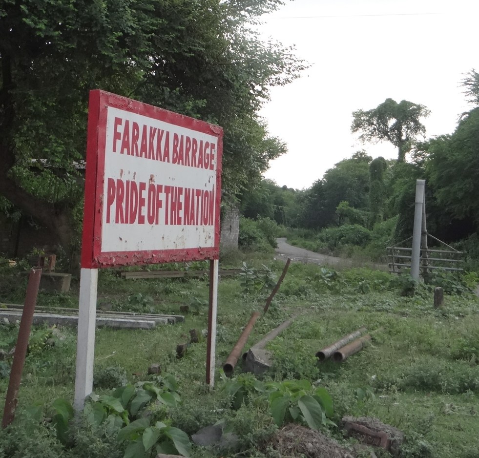
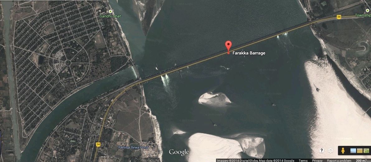
GOOGLE IMAGE OF FARAKKA BARRAGE

The 2245 m long Farakka Barrage is one of the most debated river management projects though for reasons which have nothing to do with either environmental or demographic reasons. Built primarily to serve the twin purpose of regulating the amount of Ganga water to flow out from the Indian territory into Bangladesh (East Pakistan then); and to ensure that sufficient water is diverted to Hooghly river to enable the regular flushing of silt at Calcutta port, the Farakka Barrage has been more often mired in controversy as India and Bangladesh have disagreed over the share of Ganga water between the two countries. While in the recent past, some efforts have been made to resolve this contentious dispute between the two nations, no thought has been spared so far on the long term impact the barrage has already caused and continues to do on an ongoing basis.

Though the Farakka Barrage was commissioned in 1975, work on the project had been going on for long. The structure of the Barrage was completed as early as in 1971 but the feeder canal which diverts water to the Bhagirathi river (as the Hooghly is called at this point) was completed only in 1975. By this time however, the cost of the project had escalated and when it was finally completed, the Farakka Barrage cost the nation Rs. 156.49 crore. The cruel irony is that since its commissioning, the Farakka Barrage has cost the nation much more but leave alone calculating the total cost, barring a handful, no one is even willing to concede the fact that the Barrage has caused irreversible harm to environment and society. The Barrage is being maintained by the Farakka Barrage Project (with 878 employees[1]), under Union Ministry of Water Resources, with jurisdiction upto 40 km upstream of the barrage, 80 km downstream along the right bank feeder canal and in the downstream area upto Jangipur barrage[2].

The Farakka Barrage was modelled on the lines of the Damodar Valley Corporation (DVC)- one of the first major riverine projects undertaken by the Central government under the influence of Nehruvian model. Both the DVC and the Bhakra project in the northern India were reflective of the government’s viewpoint that river management projects in India needed to be modelled on western lines – with its emphasis on large dams. In fact, plans for the DVC had already been drawn up by the British before independence during Lord Wavell’s tenure as Governor General. The entire project was modelled on the lines of the Tennessee Valley Authority of America and its chief engineer was actually appointed by the government of Independent India as the Chief Administrator of the DVC. When the DVC was planned and work on it was initiated in the late 1940s & early 1950s, the government was lavish on its claims regarding the benefits from the project. For eastern India, the DVC was considered to be a panacea to several problems in areas of power, irrigation and flood control. But as experience later showed, the claims had been falsely made on all fronts: the DVC in fact, made more areas in West Bengal prone to flood than before; the project’s utility in irrigation & power generation programmes was minimal.

Faulty Projections

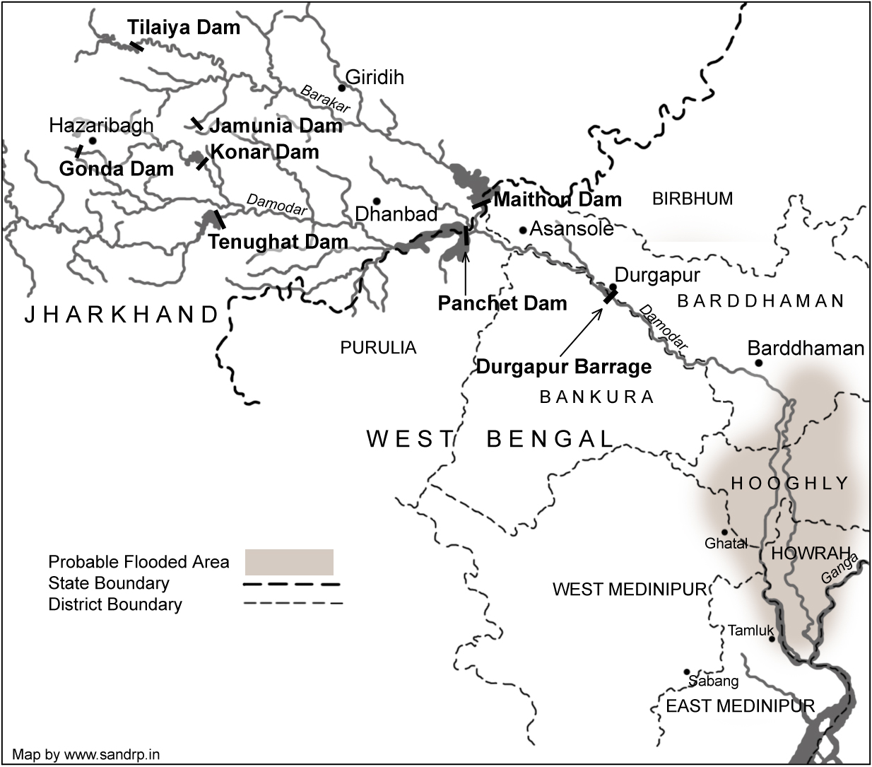
By the late 1950s evidence was mounting that the projections made by the planners of the DVC had got it all wrong. The greatest demerit in the DVC was the sharp decline in the discharge capacity of Damodar river: from a level of 50,000 cusecs in 1954, the figure touched abysmal level of 20,000 cusecs. By 1959, the depth of Calcutta port had declined considerably after the construction of the Maithon and Panchet dams. The discharge capacity of several other rivers in the region like Jalonshi, Churni, Mayurakshi, Ajai and Roopnarayan also declined greatly and further contributed to the rising bed of the Hooghly. The situation slowly started reaching the point of no return and by the late 1950s, large ships stopped coming to Calcutta port and instead opted for Diamond Harbour.

Image

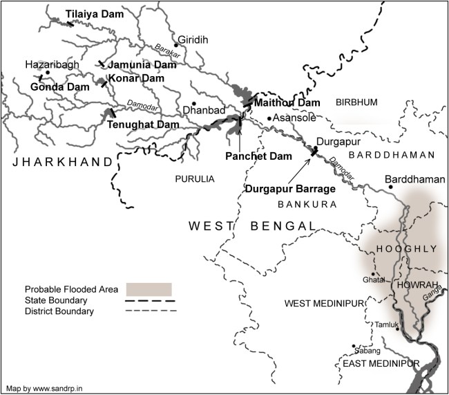
SANDRP MAP OF DAMODAR VALLEY DAMS

These facts were not hidden from the policy makers and planners when work on the Farakka Barrage was initiated. Yet, they chose to remain myopic and contended that the Barrage would flush out silt and mud from the Hooghly and thereby it would be possible to reclaim Calcutta port. What was ignored was the fact that till the DVC project had been initiated, the problem of Hooghly not getting desilted had never risen because of the nature and timing and force of the floods in the Damodar and Roopnarayan rivers. But, once various dams came up in the course of the DVC, these rivers lost their capacity to flush the Hooghly thereby jeopardising Calcutta port.

The Farraka Barrage was thus intended to correct a un-envisaged adverse impacts created by DVC dams. However, as events have proved, the step taken to correct a previous wrong move also turned out to be a faulty and unwise decision. However, it is not that words of caution were not available when the DVC dams or the Farakka Barrage were initially planned: they were only not heeded. To illustrate, Kapil Bhattacharya, an engineer in West Bengal contended that the amount of water that could be diverted from the Farakka Barrage into the Bhagirathi, would not be sufficient to flush the Hooghly to the level that Calcutta could once again be used as a port. He also suggested that the DVC should be modified in a manner so that water from river Roopnarayan flows into the Hooghly which would ensure regular flushing of the river. Regarding the Farakka Barrage, Bhattacharya further said that the project would reduce the water carrying capacity of the Hooghly and thereby make more areas in West Bengal prone to floods. He had further cautioned that there would be heavy silt accumulation even in river Padma on the Bangladesh side of the border and this would further make areas on the right bank of Padma flood prone.

Creating Problems at both Upstream and Downstream                                                                  

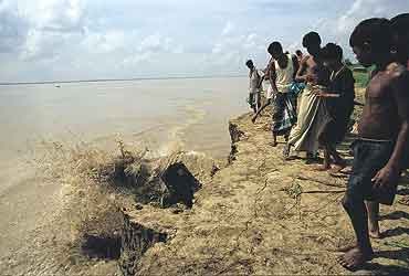
An alarming development has been the steady decline of the Ganga’s depth. In 1975, when the barrage was commissioned, the depth of the river at the barrage was 75 feet. In March 1997 when I visited the area with some friends, we were shocked to find that the depth of the river was only 13 feet. In effect, this means that the bed of Ganga had risen by 62 feet in the past years. Latest report shows that Ganga has become a havoc and the erosion goes on increasing year after year at Malda and Murshidabad districts.

Actually the Ganga river system transports vast amount of fluvial sediment. The Ganga used to be desalted up to 150 feet during flood season every year. On construction of Farakka barrage natural flushing of the sediment has been obstructed.

Image

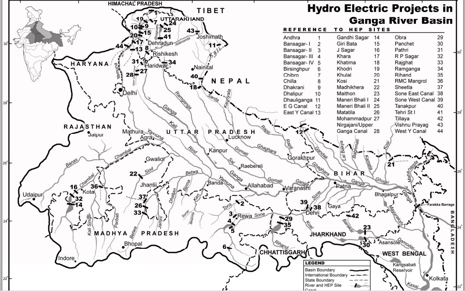
Ganga Basin Map (source: https://sandrp.in/basin_maps/)

This alarming development has led to untold misery to the people of Gangetic region of West Bangal, Bihar and Eastern UP as the level of the bed of all tributaries of Ganga has risen steadily. As a result, thousands of Chaurs (lowlands) that previously used to remain flooded only during the monsoons, now remain submerged under water for as long as ten months. The problem of constant water logging not only leads to possibilities of the outbreak of infectious diseases, but also causes unfathomed economic and social miseries on the people in these regions. Nature of the soil becomes alkaline and already lakhs of acres of once fertile land in Bihar have now turned totally barren. The fertility of the Gangetic plains today is a poor image of yesteryears.

While the problem of submergence as a result of the Farakka Barrage is acutely felt upstream of the barrage, the problem is one of erosion downstream of the barrage. As the water discharged into the Bhagirathi and the Padma is devoid of any silt, the water tends to cut into the land more sharply than in the past. As a result the problem of soil erosion is being very acutely felt in villages and towns on the banks of the Bhagirathi.

Depletion of Fish Resources

Besides water depletion, river diversion and dam projects also wreak havoc among the fish living in these waters. These projects adversely affect the fisheries which are migratory in nature. Dams and barrages act as barriers in their migratory paths and several species have either already become extinct or are facing extinction as they breed in a particular type of water while inhabiting in a different sort. The Farakka barrage has over the years acted as a barrier to the migration of marine & deltaic fish leading to the near absence of several popular varieties in the entire northern India. As the waters of several rivers of northern states directly or indirectly flow into the Ganga, there is a similarity in the type of fish found in the rivers. There are many aquatic verities (for instance prawn) that inhabit in fresh water but breed in marine water. Likewise, there are other species – like Hilsa – that inhabit in marine water, but have migrated upstream to breed. The Ganga once used to have plenty of Hilsa but this has changed as the fish is no longer able to breed leading to the near extinction of the Hilsa in the Ganga upstream of the Farakka Barrage.

In fact, it is not just a question of Hilsa alone, but there has been a substantial drop in the fish population on the entire Ganga. Prior to the barrage, during monsoon, there used to be a very high population of eggs and spawns in this stretch (UP and Bihar upstream of Farakka) of Ganga. After catering to the local needs (there is great demand for fish in Bihar and eastern UP) a substantial amount of eggs, prawns and different varieties of fishes used to be sent to other states. Today barely about 25 per cent of the local demand is met by the fish caught in this stretch and for the rest; the people have to depend on fish caught in other states.

It has been estimated that there has been an overall decline of 80 per cent in the entire population of fish upstream of the Farakka Barrage. Large fish, once found in abundance in the Ganga and its tributaries are no longer available and millions of traditional fishermen who have made their living for generations by catching fish now face destitution. What had previously been a close relationship between the fishermen and local customers have now been replaced by a cold system comprising air-conditioned trucks and ice-laden crates of fish brought in by large companies from other states like Andhra Pradesh. This not only makes the fish beyond the reach of the poor, but also alienates traditional fishermen from their ancestral profession in a situation where they do not have the training to do other jobs.

The Farakka Barrage has adversely affected the ecology and economy of Bangladesh too. Before 1975 Ganga used to flush out the Padma basin in Bangladesh and spread the alluvial soil in agricultural fields. But the barrage has disrupted this natural process. Now tides of the sea fill sand in the bed of Padma and also fields around it. Lakes and ponds are filled with saline water. The ground water level has fallen down resulting in drying up the shallow tube wells and dug wells. The Barrage has caused serious damage to land and populace both upstream and downstream of the barrage. Corrective measures are called for immediately and if not taken then there are portents of much greater havoc both to the people and to the land.

Chain of barrages will worsen the situation

The new plan of union government[3] to built chain of barrages along Ganga, every 50-100 KM will further worsen the situation. Natural process of silt transport and distribution in flood plains will be completely obstructed and breeding of migratory fishes will be further disturbed. The government should review this plan. A high level inter-disciplinary team need to be appointed to study at length the problems that have surfaced on account of the Farakka barrage and suggest measures that can be initiated to reverse the process of the damage. This plan will not succeed in either making Ganga Navigable or help the cause of rejuvenation of Ganga that the new government claims it is committed to. Strangely, the plan was announced without any details, public participation, environmental impact assessment, social impact assessment, public participation or participatory decision making. Free flow of Ganga is essential for rejuvenation of this holy river.

Ganga Mukti Andolan

Since 1982 fisher-folk and peasants of gangetic region are contending that rivering projects like dams, barrages and embankments are leading to economic downfall on account of fish depletion, submergence and fertile tracts turning alkaline. The Ganga Mukti Andolan has its origins in the resistance to the system of ‘Panidari’in Bihar. Under this system, waterlords and power contractors had fishing rights of Ganga and its tributaries. After a long struggle zamindari (Panidari) and contract system was abolished in January 1991 and traditional fisher people were given free fishing rights in 500 KM stretch of Ganga and in all rivers passing through the Bihar state. The movement continuously raised the issue of pollution caused by factories and thermal power station. Ganga Mukti Andolan has thus, moved from a movement of social and economic equity to one that questions the very model of development that is destroying the Ganga and those who depend on it. The movement wants a new direction for river management.

(Contact address of author: Anil Prakash, Jayaprabha Nagar, Majhaulia Road, Muzaffarpur – 842001, Bihar. Mobile – 09304549662, email – anilprakashganga@gmail.com)

END NOTES:

[1]Annual Report of Ministry of Water Resources, 2011-12

[2] http://mowr.gov.in/forms/list.aspx?lid=252

[3]PIB press release of Ministry of Water Resources on June 6, 2014

Climate Change · South Asia

Climate Change, Migration and Conflicts in Assam-Bangladesh: Why we need better reports than this

A new report named “Climate Change, Migration andClimateMigrationSubContinent_COVER Conflicts in South Asia: Rising tension and Policy options across the sub-continent” was published in December 2012 by Center for American Progress and Heinrich Böll Foundation. This report, authored by Arpita Bhattacharyya and Michael Werz has analyzed how migration and security concerns are overlapping in the era of climate change in South Asia. Even though the title of the report mentions South Asia, it is mainly focused on India and Bangladesh. The central argument of the report is that an inevitable threat of climate change will intensify migration from Bangladesh to Northeast India, in general and Assam in particular.

In this report the authors have examined the role of climate change, migration, and security broadly at the national level in India and Bangladesh. Discussing the focus and relevance of the report the authors write “In this paper we examine the role of climate change, migration, and security broadly at the national level in India and Bangladesh—and then zero in more closely on northeast India and Bangladesh to demonstrate the interlocking problems faced by the people there and writ larger across all of South Asia.” But the report falls short of indentifying a causal relationship between climate change, migration, and conflict. This report emphasizes on understanding climate change, migration and security as three distinct layers of tension and assesses scenarios in which the three layers will overlap. The report takes Assam, the central state of northeastern border of India as a case study where the three factors converge. But the elements related to this convergence are rather inadequate that required further probing.

The report discusses the Assam movement of 1983 and the    clashes which  occurred in the summers of 2012 between ‘members of the Bodo tribe and  and  Muslim community’. Bringing climate change into the framework the report states “In assessing the security challenges of climate change, Assam provides an example of several factors coming together in a complex way. Climate change will stress existing migration patterns both locally and internationally in Bangladesh. Even more importantly, the perception that there has been an increase in immigrants has the potential to stoke tensions over immigration in Assam.” It seems to be generalization of a very complex process. We have found towering claims like this have very less linkages with the situation on ground(please see our blog – 2012 Floods Displaced 6.9 Million in Northeast-IDMC: Staggering but Highly Exaggerated). The report also mentioned that “Floods in September 2012 displaced 1.5 million people in the northeastern state of Assam” this again is not beyond doubts. The data available from National Disaster Management shows that, highest number of people affected in the floods in September 2012 is 383421.

Climate Change Scenario in India: For India the report draws from the “Climate Change and India: A 4×4 Assesment” (2010) which was prepared by the Indian Ministry of Environment and Forests for examining climate change impacts and projections through 2030 across four regions of India (the Himalayan Region, Western Ghats, Northeastern Region, and the Coastal Region) and four key policy sectors: agriculture, forests, human health, and water.

Bangladesh Discussing the situation in Bangladesh the reports deals with rising temperatures which are likely to have severe effects on agricultural production in Bangladesh due to higher rates of evaporation and changing rainfall patterns. According to the authors “Bangladesh could see up to an 8 percent reduction in rice production and a 32 percent reduction in wheat production by 2050…. With 63 percent of the population dependent on agriculture for basic livelihoods, the rise in temperatures could be crippling.”

The report warns about increases both in extent and frequency of floods in the country. Talking about rise in sea level the report states, “The Bangladeshi government projects that the sea level will rise by 5.5 inches (14 centimeters) by 2030, 12.6 inches (32 centimeters) by 2050, and 34.7 inches (88 centimeters) by 2100. Predictions about the displacement of people resulting from a 1-meter (roughly 40 inches) rise in sea-level range from 13 million to 40 million in Bangladesh alone.” The report also discusses cyclone and storm surges, river and coastal erosion and saltwater intrusion. Bringing migration into the picture, the report first discusses rural urban migration within Bangladesh and describes a situation of migrants in the capital city Dhaka “When describing why they came, migrants tell stories of flood and famine in quiet rural towns where options dwindle by the day … these villagers pour into Dhaka at a rate of about 400,000 to 500,000 each year.”

Talking about international migration from Bangladesh, the report states “More informal—but still substantial—migration takes place from Bangladesh to India, especially to the far eastern Indian states of West Bengal and Assam….. It is estimated that approximately 12 million to 17 million Bangladeshi immigrants have come to India since the 1950s, with most residing in the northeast states of West Bengal, Assam, and Tripura.” In this situation presenting the interplay of migration and climate change the report says, “How climate change will effect migration to Bangladesh’s urban centers is not exactly determined. Even more uncertain is how climate change and Bangladesh’s urban growth will interact to shape international migration, particularly to India. But given the trajectory of available climate change projections and historical precedent, India may continue to be a popular destination for many Bangladeshi migrants.” However this seems to be an opaque statement without any substantiation. Instead of pitching their argument in the ahistorical categorization between an underdeveloped Bangladesh and an emerging India, the author should consider the present human development indicators of Bangladesh vis-à-vis India  (please see “Social indicators of Bangladesh are better than India”).

As a part of the solution, it suggests building of sustainable urban areas where governments manage to guarantee food security, deliver required energy resources, and develop infrastructure to more effectively protect livelihoods in rural areas. However, its suggestion that “economic growth must be maintained to accommodate growing populations and allow society to better prepare itself to deal with the impacts of climate change” seems to suggest that the authors have not understood basics of both economic growth and re-distribution as well as  climate change.

The American Perspective The paper does not provide any adaptation and mitigation measures for climate change. The paper argues for changing the pathways of growth towards greater sustainability. Talking about modern sustainable urban centers the paper focuses on the areas where U.S.-Indian cooperation can happen. The report is written in order to assess how United States can play a pivotal role in the threats and consequences of climate change arena in South Asia and that is why ‘the American perspective’ on the climate change in South Asia can be all pervasively found in the report. The report propose three policy collaborations that the United States can take up with South Asian partners as complex crisis scenarios unfold in the wake of climate change – 1. High-level climate-vulnerable cities workshop, 2. A dialogue on migration and 3. Ecological infrastructure development.

Pressing Critical issues

There are a lot of critical issues with this report which needs to be addressed.

How much migration is actually happening now: The report establishes its firm belief in the fact that large scale migration from Bangladesh to northeastern parts of India is still continuing. The report should have first questioned how much migration is actually happening rather than claiming that there will be increase in migration in the near future. There were several analysis available specially drawn from Government of India’s Census data which shows a complete different picture.  In an article named “Riots & the Bogey of Bangladeshis”, published in Hindu on 8th August 2012,  Delhi base researcher and activist Bonojit Hussain did an analysis of census data and reported that “Even though the religion-wise census figures for 2011 are not yet available, provisional results from the 2011 census show that the decadal growth rate of population between 2001-2011 for Kokrajhar district is 5.19 per cent, interestingly, marking a decline of 9 per cent as compared to the decadal growth rate of 14.49 per cent between 1991 to 2001. (The decadal growth rate for Assam between 1991 to 2001 was 18.92 per cent and 16.93 per cent between 2001-2011)……. The other possibility, which seems more plausible, is that there has been a considerable out-migration from Kokrajhar, especially after the formation of the BTAD in 2003. Since the Bodos (who constitute 20 per cent of the population in the BTAD area) hold a monopoly over political power in the area, it is unlikely that there has been any significant out-migration of the Bodo population from Kokrajhar district. The Koch Rajbangsis, who constitute roughly 17 per cent of the total population of the BTAD, have been campaigning for and demanding a separate homeland — Kamtapur — which territorially overlaps the BTAD, thus making it unlikely that they would out-migrate, abdicating their political claim over the territory. In all probability, the out-migration involves other non-Bodo communities, including Muslims.” The report seems to ignore this reality. It is also important to note that the report has very little to substantiate its assumptions.

Social indicators of Bangladesh are better than India: The report seems to ignore the substantial improvements in social indicators in Bangladesh. A recent review of Jean Drèze and Amartya Sen’s new book ‘An Uncertain Glory,’ states the improved social conditions of Bangladesh in the following way “even Bangladesh has better social indicators than India. It has higher life expectancy (69 vs India’s 65), better sanitation (half of all homes in India have no toilets compared to 10 per cent in Bangladesh), lower infant mortality (37 versus India’s 47) and lower fertility rate (2.2 against 2.6 for India). For those arguing that Bangladesh is a much smaller country, the answer is that its GDP per capita is roughly half that of India’s.”[1]

Is urbanization the only option: The report is biased towards urbanization. The report shows no interest to discuss how rural areas can be prepared to face climate change better. Projecting sustainable urbanization as the solution for migration is presenting only one side of the story. The report also seems like an attempt to push forward American agenda in South Asia. The report laments the facts that the urbanization programmes like JNNURM is facing shortage of funds.  But there are already several examples JNNURM programmes in India which are increasing the debt burden on the people and undermined the traditional sustainable systems.

Are thermal and large hydro-power projects climate friendly: The report on climate change shockingly, reemphasizes on coal based power generation. A study on climate change prescribing for coal based power generation is really very strange.

In another surprise the report, shows bias for (large) hydro power generation, even though hydro-power dams have very severe impacts on river ecology, bio-diversity and climate change. While discussing about water politics between China, India and Bangladesh the report mentioned about the fear of water diversion by China through hydro power dams and its severe impacts on flow of the Brahmaputra. But it makes no mention of more than 150 hydro power projects, which are being planned in Arunachal Pradesh and other north eastern states within the Indian territory and the downstream impacts of these. These projects will dam every major tributary of the Brahmaputra River. These tributaries collectively contribute at least four times more to the flow of the Brahmaputra than Yarlung Tsangpo or Siang, the part of Brahmaputra which flows from China. The report has no reference to any of this.

Internal migration within Assam and India: The report talks about migration from Bangladesh to Assam but it makes no mention of people migrating from rural areas of Assam to other cities due to severe flood and erosion. The report also does not take into account the case of char-dwellers (people living in sand bars) in Bangladesh and Assam. According to the Socio Economic Survey of 2003-04 in 14 districts of Assam, there were 2251 char villages with a population of 24, 90,397.[2] People who live on chars in Assam and in Bangladesh will be directly affected by any change in flow pattern in the rivers.

Spreading propaganda? Though this report is on migration from Bangladesh to Assam, the report presents very little data to back up its claims. Besides, on the issue of increasing Maoist activity in India, the report does a shoddy job. The map showing maoist activities in India is questionable. Since this report accepts the current development path of coal based and large hydro-based power generation unquestionably, the discussion on Maoist activity in India resonate with Assam’s Chief Minister Tarun Goigoi’s unfounded attempts at colouring of anti-dam struggle of the people in Assam as Maoist activity. Such uncritical acceptance of Indian government’s unfounded assertions discredits the report.

Parag Jyoti Saikia


[1] http://www.thehindu.com/books/books-reviews/the-inequalities-of-democracy/article4941693.ece

[2] Chakraborty G.,”Distortion  of Natural Watersheds and Land Erosion: The Char Areas Of Assam”, SIBCOLTEJO, Vol. 05 (2010): 18-30

Floods · International Water Issues · Ministry of Water Resources

Bangladesh’s Amazing and New Flood Forecasting: A Tip for India’s CWC to Improve its Flood Forecasting Performance

Bangladesh has come up a new flood forecasting and warning system with several amazingly useful features of forecasting floods available on their website from June 2013. Flood forecasting is a vital non-structural measure to mitigate flood losses which can be very useful for a deltaic nation like Bangladesh which face brunt of floods annually. The Flood Forecasting and Warning Centre (FFWC) is under the aegis Bangladesh Water Development Board and is supported by UNDP through the Comprehensive Disaster Management Programme (Phase II) and Ministry of Disaster Management and Relief. The website can be accessed at http://www.ffwc.gov.bd/index.php.

ps 1

While the features have become available on website since June 2013, many of them have been otherwise available since 2011. In fact, Interactive Voice Response [Calling from mobile (phone no- 10941), flood and weather messages can be heard in Bangla (charge applicable)] facility is available since 2011.

The Deltaic Bangladesh Geographically, Bangladesh is country located in one of the biggest active deltas in the world with an area of about 1,47,570 sq km.  The climate of the country is subtropical-monsoon climate where annual average precipitation is 2300 mm which varies from1200 mm in the north-west to over 5000 mm in the north-east. Bangladesh, as stated in its Annual Flood Report of 2012, has a total of 230 rivers out of which 57 are Transboundary Rivers. 54 of these transboundary river flows from India to Bangladesh which includes the Ganges and the Brahmaputra. Bangladesh consists of flood plains of the Ganges, the Brahmaputra and the Meghna rivers and their numerous tributaries and distributaries. The FFWC carries out monitoring of 86 representative water level stations and 56 rainfall stations across Bangladesh.

The FFWC Website The homepage of the FFWC website presents a map of the whole country and its rivers, marked with flood forecasting sites in Bangladesh which is really useful for a number of reasons:

(i) For a first time visitor it gives a good idea of the rivers in Bangladesh and their flood forecasting sites.

(ii) When the cursor stops at a particular forecasting site, a pop up site appears with location details, water level, highest water level and danger level at that particular site.

(iii) with locations of forecasting sites on the same river clearly marked, one can get an overview of the situation across the river basin.

(iv) colour code of the symbol at each FF location gives an idea if the water level is above/ below warning or danger level or High Flood level.

ps 8

The homepage of FFWC offers an option to view the whole website in Bangla. This is very welcome and useful since this important information can be accessed and used by people in local language.

The home page also provides information on the sites where water level is currently on the rise or above the danger mark. Below the line of tabs of the website, name of the sites where water level is on the rise keeps on scrolling. Clicking in any of the sites in the scroll, leads to a pop-up where the rise in water level is presented in graph for the previous one week. The rise in water level for each day is also showed according to time which appears when the cursor is kept on any of the dots of the graph.  This pop up can also be saved either as a photo, as a pdf or as a SVG vector image.

The FFWC website provides rainfall data and water level data of every designated site in the four river basins of Bangladesh under the ‘data’ tab: Bramaputra (13 sites), Ganga (17 sites), Meghna (15 sites) and South East Hills (10 sites).  The rainfall data table gives rainfall of the day, along with previous two days rainfall, normal monthly rainfall and cumulative rainfall for the month. But here FFWC can add the total rainfall data for the whole season which will make it more useful.

The water level data table provides water level of the day, previous day water level and projection of water level for the next three days along with name of the river and location name for 38 sites in Brhamaputra basin, 27 sites in Ganga basin, 26 sites in Meghna basin and 7 sites in South East Hill Basin. ps 10

The FFWC website under the ‘Forecasting and Warning’ tab provides very substantial information regarding floods under following heads: ‘Flood Summary’, ‘Flood Bulletin’, ‘3-day Deterministic Flood Forecast’, ‘5-day Deterministic (experimental) Flood Forecast’, ‘Medium Range (1-10 Days)Forecast’ ‘Structure Based Forecast’ (available for a few structures like embankments or bridges on experimental basis) and ‘Special Outlook’ (only in Bangla language).

Under the ‘Map’ tab, the website has ‘Rainfall Distribution Map’ and ‘Inundation Map’. The rainfall distribution map[i] provides at a glace picture of rainfall over the last 24 hours. The latter provide the options to view inundation maps[ii] for the given day and forecasts for next two days, both for Dhaka and for Bangladesh as a whole. ps 2

ps 7

The ‘Reports’ tab holds annual reports on floods in Bangladesh for last five years. In the ‘Hydrograph’ tab, the website first provides of forecast of water level for each site through a graph. Under ‘Forecast’ the website provides observed water level at each selected site for the day, previous six days (with all the observations available on the graph) and forecast for the next three days. This is provided for 89 sites which include 8 sites from South East Hills basin, 26 sites in Meghna basin, 21 sites in Ganga basin and 34 sites in Brahmaputra basin. Division wise break up is: Borisal-1; Chittagong-11; Dhaka-30; Khulna-6; Rajshahi-14; Rangpur-12; Sylhet-15. It also provides monsoon hydrograph for 104 sites, where the water level throughout the monsoon is given, some of the graphs seems to show flat levels, though, raising questions if these are providing correct information.

Here for some sites several selected years’ monsoon season data is also represented through graph for some of the sites but it becomes bit confusing since no rational for choosing a particular year is provided. Providing the basis for choosing a particular year monsoon will clarify the picture. In both ‘forecast’ and ‘monsoon’ options the sites are presented not only river basin wise but also on the basis of regions making it more easy to use. Hydrograph also includes ‘Real Time Data’ of three sites. The real time data of these three sites presents the water level from one day to last 60 days through graph.

ps 9

GoI-CWC’s Flood Forecasting website If we compare this with the flood forecasting website of Government of India’s Central Water Commission (http://www.india-water.com/ffs/index.htm), the CWC site home page has two options ‘list based’ and ‘map based’ but the latter surprisingly never worked for this whole monsoons season, it has never worked, it seems. Clicking on the map based option leads to page which asks for plug in download. There is also an option for map browser installation but that never worked.

The ‘list based option’ has the flood forecasting sites under three options – state, basin and region-wise. But there is no page where all the flood forecasting sites can be found at one place. CWC flood forecasting site provides forecasts available at a given point of time, only for one day and which is removed as soon as the time of forecasting gets over. The forecasting in table format is made only for those sites where the water level has crossed the warning level. The CWC flood forecasting website does not provide three day, or five day or ten day forecasts. This is in contrast with the flood forecasting done by Bangladesh because the website provided water level data for each site in the country in one place and it is fast, more responsive and user friendly. Besides, on CWC site there is no option of keeping a record of previous forecasts. All the forecasting data available in the CWC website is available in English and not even in Hindi.

In case of CWC, there were also instances when water level even after crossing the danger level did not appear in the flood forecasting table. This has been observed for example in case of the Sahibganj site on the GangaRiver. Sahibganj did not appear in the flood forecasting table even for once even though the site was witnessing low to moderate floods as shown in the list base option of the same website.

There are also several other issues with the CWC flood forecasting website e.g. wrong flood forecasting, no forecasting of the floods during the Uttarakhand disaster and inadequate flood forecasting sites which had been pointed out to CWC by SANDRP[iii].

CWC need to do serious homework to improve its performance in flood forecasting for and in doing so it can take some good lessons from Bangladesh.

Extending the forecasts to GBM basin There is a huge scope for Transboundary cooperation in extending the flood forecasting across the countries sharing Ganga-Brahmaputra-Meghna basins, including Bangladesh, India, Bhutan, Nepal and China. In fact Md Amirul Hossain, Executive Engineer at FFWC wrote to SANDRP in response to a question, “The FFWC of Bangladesh has been receiving little (rather very little) upstream data/ information on water level or flood situation. This little data helped us very much for generating everyday flood forecasting. If we would be in a position to share hydro-met data of the upstream, most of within India, few in Nepal & Bhutan, then the Flood Forecasting and Warning Lead time could further be increased/ extended. FFWC-Bngladesh likes to share the information, skill and experience and would be happy to participate in an effort to develop “BASIN FLOOD FORECASTING AND WARNING” for Brahmaputra-Ganges and Meghna basin (GBM-Basin).” It is heartening to see this offer from FFWC, Bangladesh. We hope steps will be taken to realize this potential and more and transparent sharing of flood forecasting information across the countries will be a reality soon.

 Himanshu Thakkar and Parag Jyoti Saikia