Dams

Maletha; Redefining ‘Development’ to Protect Cultural and Natural Heritage

About Maletha Placed in middle Himalaya, Maletha[1] is a prosperous village of about 450 households in Tehri district of Uttarakhand. The village is settled next to National Highway 58, on right bank of Alaknanda River at a vertical distance of 400 meters in Kirti Nagar block. It is about 25 km upstream from Devprayag where Alaknanda from left and Bhagirathi from right side, unite to form the Ganga River. 
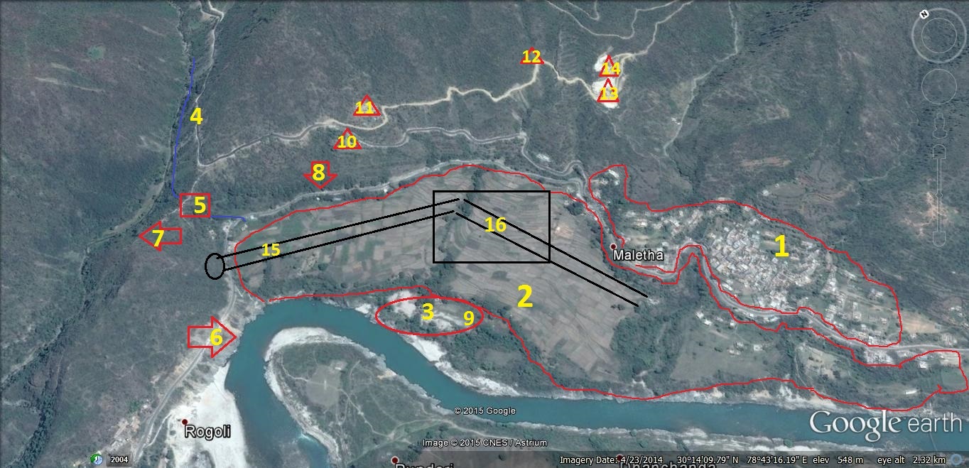
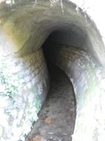
Goggle Imagery of Maletha Village
Goggle Imagery of Maletha Village (30*14’01.95” N 78*43’24.69”E elev 572 meter)
1- Maletha Village 5-Tunnel part of irrigation channel* 9- 2013 flood affected farm * 13- Stone Crusher
2-Maletha Farmland 6-Alaknanda River 10-Stone Crusher 14- Stone Crusher
3- Maletha Temple 7-Chandrabhaga River 11- Stone Crusher 15-Proposed Railway line
4- Maletha Irrigation Channel 8-National Highway-58 12- Stone Crusher 16-Proposed Railway Station

5* Villagers have built Madho Singh Bhandari’s memorial there                                                                                              9* June 2013 flood has deposited about 25feet high sand on river banks and submersed around 10 acres of agricultural land turning them unproductive.

Continue reading “Maletha; Redefining ‘Development’ to Protect Cultural and Natural Heritage”

Dams · Interlinking of RIvers · Maharashtra · NWDA

Par-Tapi-Narmada Link: Divided States, United Tribals

Above: Just a few hundred meters upstream the proposed Jhari Dam, a tribal woman struggles to find water in the dry Par river bed Photo: Parineeta Dandekar

Village of Jhari at the northern most corner of Western Ghats has some of the loveliest houses I have seen. Appreciation for the evolved vernacular architecture goes beyond the obvious urban romanticisng of anything tribal. Homes in this region of tribes like Kokani, Warli, Thakurs, etc, are unique in their architecture, building materials, craftsmanship and the seamless mix of beauty and functionality. The tiled roof of our host Haribhau had intricate wooden trimmings, the mudfloor was cool and the door frame was carved in exquisite motifs. Vines arched and spread in disarray over courtyards. We were assembled under a passion fruit or ‘Rasna’ vine, bursting with white flowers. Inside, cane baskets creaked under the weight of Ragi, Udid and Rice filled to the brim: This year’s harvest has been good, though that’s not always the case. The hosts, both men and women, were busy with lunch preparations. Continue reading “Par-Tapi-Narmada Link: Divided States, United Tribals”

Dams

Blow by Blow, how pollution kills the Yamuna  river: A Field Trip Report

              Yamuna River from Hathini Kund Barrage to Delhi (All maps from Google Earth, created by author)

A field trip along the Yamuna River this April 2015 showed how the river is killed blow by blow, by the pollution and diversion. The visit was planned with an objective to study and observe actual status of industrial and domestic pollution reaching River Yamuna via various Escapes and Drains in Haryana, upstream Delhi. A team of two members Sri Manoj Misra, Yamuna Jiye Abhiyan and Bhim Singh Rawat, SANDRP spent three days (03-05 April 2015) closely travelling along the river through four districts of Haryana (Sonipat, Panipat, Karnal and Yamuna Nagar) and tracking various drains, escapes (from origin) which pour massive amount of effluents  in River Yamuna . Continue reading “Blow by Blow, how pollution kills the Yamuna  river: A Field Trip Report”

Arunachal Pradesh · Bhutan · Cumulative Impact Assessment · Dams · Hydropower

Cumulative Impact Assessment of Tawang Basin: Highlights from the NEHU Study

“We want sacred rivers of Tawang to flow freely, not inside Tunnels!” What makes the assertion on this banner more remarkable is the fact that the people holding it up are not fiery activists, but peace-loving Buddhist monks of the Monpa community, from the farthest corner of Arunachal Pradesh: Tawang (photo by Urmi Bhattacharjee).  About 13 hydropower projects are slated to come up on main river stem and tributaries of Tawang Chhu (River) in Tawang in a distance of just  160 kms[1].

Monpa Child from Tawang Photo: tawang.nic.in

Tawang is a tiny district of Arunachal Pradesh nestled between Tibet and Bhutan. The region has had a troubled past and is home to Monpa Buddhists who practice an ancient form of Buddhism. Monpa culture itself is unique and fragile, with less than 50,000 Monpas in Tawang and less than one lakh globally. The region is famed for Tawang Monastery, Galden Namgey Lhatse (which literally means Celestial Paradise on a Clear Night), which is the 2nd largest monastery in the world. Continue reading “Cumulative Impact Assessment of Tawang Basin: Highlights from the NEHU Study”

Dams

Reflections on the Origin of the Kosi Project

Guest blog by Dr Dinesh Kumar Mishra[i] (dkmishra108@gmail.com)

I was recently trying to look into the flood history of Bihar’s post-independence period and came across this interesting article by Hari Nath Mishra written in 1950 but published on September 3, 1967 in The Searchlight – Patna. Hari Nath Mishra later became the Speaker of the Bihar Legislative Assembly, Health Minister in Bihar and also was the Central Deputy Minister of Irrigation and Power later when Dr. K.L. Rao was the Irrigation Minister at the Centre. I was lucky to have met him in 1986 when he talked about the problems ailing the Kosi Project and that the ambitions of the people were not met as the embankments constructed along the river did not serve the purpose that they were expected to. Irrigation from the project was far below the targets fixed by the Project Engineers, power production was abysmally poor and the rehabilitation of the embankment victims was in deplorable state. I quote the article verbatim here and try to give some more to it during subsequent period. Continue reading “Reflections on the Origin of the Kosi Project”

Dams

DAMS, RIVERS & PEOPLE Jan 2015 and Feb-March 2015 issues

The Jan 2015 issue of DRP magazine can be found at: https://sandrp.in/wp-content/uploads/2015/03/drp-jan-2015.pdf.

The Feb March 2015 issue of DRP magazine can be found at: https://sandrp.in/wp-content/uploads/2015/03/drp-feb-march-2015.pdf.

The Cover pages of the two issues can be seen below:

DRP Jan 2015 Cover Page

Continue reading “DAMS, RIVERS & PEOPLE Jan 2015 and Feb-March 2015 issues”

Climate Change · Dams · Maharashtra · Marathwada

Battered Maharashtra and Melting Tibet: The Climate Change Connection

Above: Nagpur or Anantnag? Hailstorms of March 2015 in Nagpur  Photo by: Atul Patne

~~

It seems like a bad deja vu.

On the 11th March last year, we wrote about hailstorms in Maharashtra. Back then, the hail, unprecedented rains, strong winds and changes in temperature had affected more than 10 lakh hectares, mainly in Marathwada and Vidarbha. After near-exact one year, we write about the issue again.

Late February and March rains have battered farmers in Vidarbha, Konkan, Marathwada and Uttar Maharashtra (Nashik, Jalgaon and Dhule Districts). Preliminary estimates state that over 8.5 lakh hectares of crops have been impacted in just 17 days and thousands of farmers and landless laborers have been affected. Continue reading “Battered Maharashtra and Melting Tibet: The Climate Change Connection”

Dams

India Budget 2015: Is there any hope for rivers, environment or farmers?

Union Finance Minister Arun Jaitley’s Maiden Full year budget presented to the Parliament on Feb 28, 2015 invited a lot of hype. Let us see what his statement of account for the 2015-16 has in store for rivers, environment, Himalayas, farmers, Climate Victims or sustainable water resources development. Continue reading “India Budget 2015: Is there any hope for rivers, environment or farmers?”

Dams

Ekti Nadir Naam: Ramblings through the etymology of River names in India

Above: Dry Chandrabhaga from Maharashtra. We have at least 5 Chandrabhagas in India! Photo: Parineeta Dandekar

~~

“I’m going to buy vegetables from the banks of Ganga. Coming?” (“गंगेवर चालले आहे भाजी आणायला. येणार?”). This was my Grandmother’s Sunday morning ritual. I always jumped at the opportunity: it meant going to the local market skirting Ganga and staring at colorful heaps of vegetables, patting dewlaps of humongous cows settled in islands, stealing guilty glances at sadhus who sold fascinating stuff: owl claws, deer musk pods, Giant Entada seeds..but most of all, it meant observing the filthy and beautiful river from the Ghats. I lived in Nashik, on the banks of Godavari and Godavari was our Ganga. Continue reading “Ekti Nadir Naam: Ramblings through the etymology of River names in India”

Dams

Landslide dam threat in Zanskar Valley to continue for more weeks: Update 2

In the most significant event so far on the issue of landslide blockage of Phutkal River in Zanskar Valley in Kargil District in Kashmir, the National Crisis Management Committee[1] (NCMC) chaired by the Union Cabinet Secretary Shri Ajit Seth met[2] on Feb 20, 2015 and approved the Action Plan whose implementation will begin within next 15 days and is to be completed by end of March. This decision is based on assumption that the snowmelt will cause landslide dam threatening situation only in April.

Tsarap Landslide location and floodpath: Map by SANDRP based on Kargil District Map from NATMO

Continue reading “Landslide dam threat in Zanskar Valley to continue for more weeks: Update 2”