In Oct. 2025, we could find at least 06 flood monitoring sites of Central Water Commission (CWC), where rivers have crossed their Highest Flood Levels (HFL) after the end of South West Monsoon season 2025 on Sept 30 2025. Of the 6 sites, 2 each are in Brahmaputra basin in W Bengal and Ganga basin in Bihar. 1 site Anantharam on Musi river in Telangana is part of Krishna basin and 1 site Marella on Gundlakamma river in Andhra Pradesh is part of East Flowing Rivers between Mahandi and Pennar basin.
The details of these 6 can be seen in the table below. The sixth column of the table is the information about rise in meter (m) over the old HFL, duration (hours-hrs) the river has stayed in extreme floods and number of years (yrs) after the HFL is breached. The details of 59 HFL breach incidents during South West Monsoon season 2025 can be seen here.
| SN | Site/ River | District/ State | Old HFL/ Date | New HFL/ Date | Rise/ Duration/ Year/ |
| 1 | Jaldhaka NH 31/ Jaldhaka` | Jalpaiguri/ W Bengal | 81.33 m/ 28.07.1972 | 81.72 m/ 10:00 hr/ 05.10.2025 | +0.39 m/ ~04 hrs/ 53 yrs |
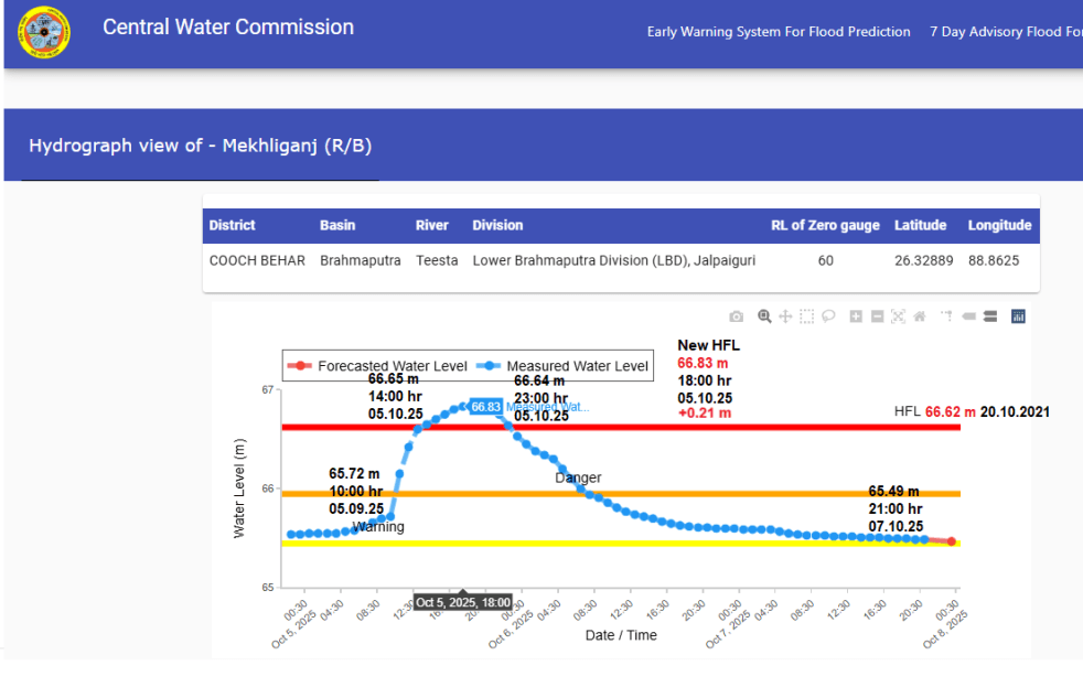
| 2 | Mekhliganj RB/ Teesta | Cooch Behar/ W Bengal | 66.62 m/ 20.10.2021 | 66.83 m/ 18:00 hr/ 05.10.2025 | +0.21 m/ ~09 hrs/ 04 yrs |
| 66.45 m/ 13.07.1996 | |||||
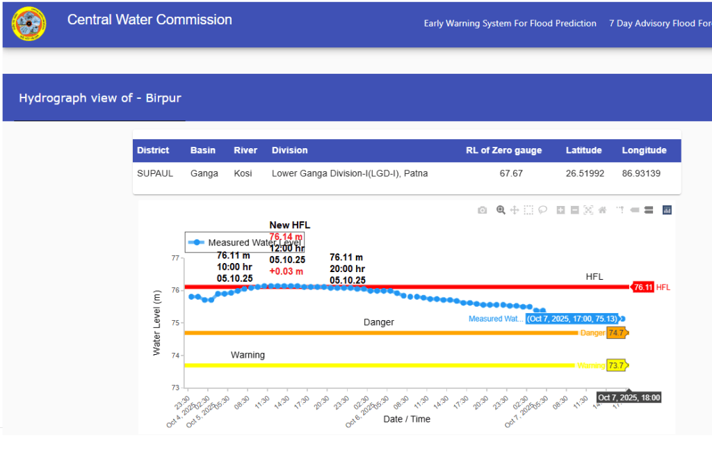
| 3 | Birpur/ Kosi | Supaul/ Bihar | 76.11 m/ 29.09.2024 | 76.14 m/ 12:00 hr/ 05.10.2025 | +0.03 m/ ~10 hrs/ 01 yr |
| 76.02 m/ 13.07.2019 | |||||
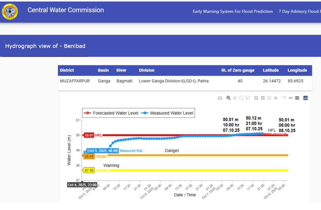
| 4 | Benibad/ Bagmati | Muzaffarpur/ Bihar | 50.01 m/ 12.07.2004 | 50.12 m/ 20:00 hr/ 07.10.2025 | +0.11 m/ ~77 hrs/ 21 yrs |
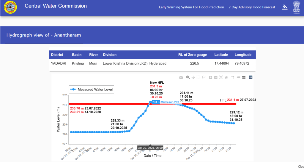
| 5 | Anantharam/ Musi | Yadadari/ Telangana | 231.1 m/ 27.07.2023 | 231.3 m/ 06:00 hr/ 30.10.2025 | +0.20 m/ ~11 hrs/ 02 yrs |
| 230.70 m/ 23.07.2022 | |||||
| 230.21 m/ 14.10.2020 | |||||
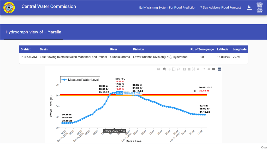
| 6 | Marella/ Gundlakamma | Prakasam/ Andhra Pradesh | 36.18 m/ 20.05.2010 | 36.52 m/ 17:00 hr/ 29.10.2025 | +0.34 m/ ~10 hrs/ 15 yrs |
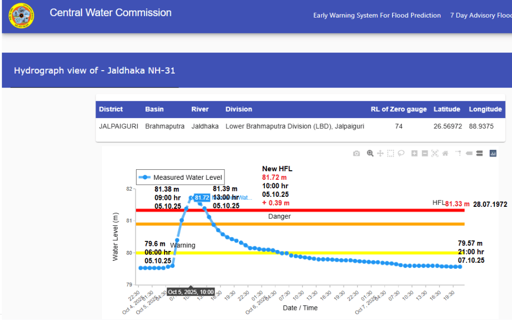
The Jaldhaka river at NH 31 site has crossed the HFL after 53 years. The 1996 HFL at Mekhliganj site on Teesta River was crossed after 25 years and the 2021 HFL has been breached only after 04 years. Bagmati river at Benibad site has crossed the HFL after 21 years. The 2019 HFL at Birpur site on Kosi River was crossed in 2024 and now the river has breached the HFL only after a year.
Interestingly, the Musi river at Anantharam site has breached the HFL 4 times in past 5 years while the Gundlakamma river at Marella site has crossed the HFL after 15 years. Of all HFL crossing events in Oct 2025 month, 4 happened in 1st week while 2 took place in the last week of Oct 2025.
Rivers Flowing Close to the HFL
Apart from HFL breach, we could track 11 sites where flood levels in respective rivers reached close to the HFL. Of these sites 2 are in Brahmaputra basin in West Bengal, 8 in Ganga basin in Bihar and 1 in Krishna basin in Andhra Pradesh. Of 8 such sites in Bihar 3 are on Bagmati river and 2 on Parnam river. While flood levels in Torsa and Jaldhaka rivers at respective sites increased close to the HFL after decades; the HFLs on all the 8 sites in Ganga basin were attained in last 8 years. The details of these sites are given in table below.
| SN | River/ Site | District/ State | HFL/ Date | Peak Level/ Date | Gap |
| 1 | Diana/ Jaldhaka | Jalpaiguri/ W Bengal | 196.55 m/ 19.07.1980 | 196.44 m/ 07:00 hr/ 05.10.2025 | -0.11 m |
| 2 | Hasimara/ Torsa | Alipurduar/ W Bengal | 118.5 m/ 13.07.1996 | 118.25 m/ 09:00 hr/ 05.10.2025 | -0.25 m |
| 3 | Sugauli/ Gandak | Paschim Champaran/ Bihar | 69 m/ 24.07.2020 | 68.71 m/ 23:00 hr/ 07.10.2025 | -0.29 m |
| 4 | Dheng Bridge/ Bagmati | Sitamarhi/ Bihar | 73.47 m/ 29.09.2024 | 73.02 m/ 10:00 hr/ 05.10.2025 | -0.45 m |
| 73 m/ 13.08.2017 | |||||
| 5 | Belsand/ Bagmati | Sitamarhi/ Bihar | 60.75 m/ 29.09.2024 | 60.5 m/ 18:00 hr/ 06.10.2025 | -0.25 m |
| 60.05 m/ 28.08.2021 | |||||
| 6 | Runisaidpur/ Bagmati | Muzaffarpur/ Bihar | 58.34 m/ 29.09.2024 | 58.3 m/ 06:00 hr/ 07.10.2025 | -00.4 m |
| 58.15 m/ 14.08.2017 | |||||
| 7 | Durgawati/ Durgawati | Kaimur/ Bihar | 70.98 m/ 01.10.2019 | 70.58 m/ 09:00 hr/ 06.10.2025 | -0.40 m |
| 8 | Saharghat/ Adhawara | Madhubani/ Bihar | 58.25 m/ 14.07.2019 | 58 m/ 12:00 hr/ 07.10.2025 | -0.25 m |
| 9 | Amour/ Parnam | Purnai/ Bihar | 39.88 m/ 16.07.2019 | 39.69 m/ 11:00 hr/ 09.10.2025 | -0.19 m |
| 10 | Bathnala/ Parnam | Araria/ Bihar | 64.06 m/ 28.09.2024 | 63.85 m/ 17:00 hr/ 06.10.2025 | -0.21 m |
| 63.61 m/ 21.10.2021 | |||||
| 11 | Munugodu/ Lower Krishna | Guntur/ Andhra Pradesh | 30.13 m/ 04.09.2020 | 29.8 m/ 06:00 hr/ 30.10.2025 | -0.33 m |
The flood level in Kallar river in Cauvery basin at Odendurai site in Coimbatore, Tamil Nadu also reached closer to the HFL 331 meter dated 02.12.2019 and 23.11.2023 around 04:00 hour on 27.10.2025 but we could not track the exact rise in the flood level in the river at the site.
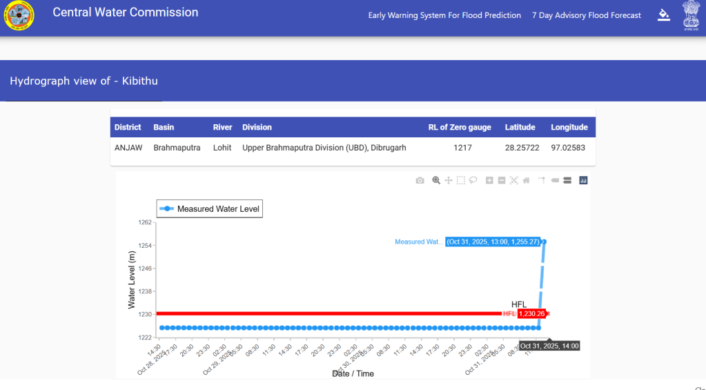
Apart from this, the CWC flood forecast website wrongly flashed HFL breach at Kibithu site on Lohit river in Anjaw district, Arunachal Pradesh on Oct. 31, 2025. Similarly, the CWC website first displayed wrong HFL for Abna at Khandwa site on Narmada river in Khandwa district, Madhya Pradesh as 299 meter on Oct. 31, 2025 and later on corrected it to 302.95 meter dated 16.09.2023. It also removed 304 meter shown as danger level for the site which was wrongly shown.


Like last year, the Narsinghgarh site on Sonar in Damoh district, Madhya Pradesh has been in severe flood situation for over a month due to recently built Sitaram dam. CWC had planned to shift the site downstream last year which has not been done so far. This year, the Barod site on Kalisindh river in Kota, Rajasthan has been in severe flood situation for about a month due to pooling condition by some downstream project.
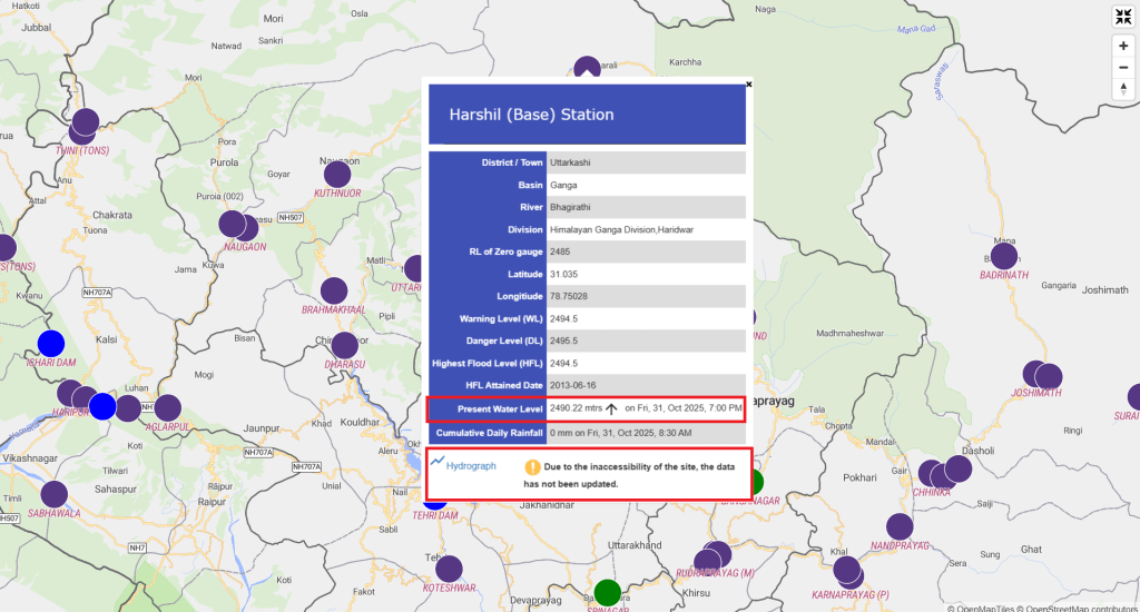
The Aglarpul site on Aglar river in Tehri Garhwal, Uttarakhand also remained in above normal flood condition for several days in October month without any significant rains. Even after more than 2 months of Dharali disaster, the CWC website still mentions that due to inaccessibility the data for Harshil site on Bhagirathi river in Uttarkashi, Uttarakhand has not been updated while the hydrograph has updated information on the water levels in the river at the site there.
SANDRP

One thought on “India’s Rivers in Extreme Floods in Oct 2025”