
Guest Article: Sridhar Radhakrishnan
The collapse of the NH66 highway in Kerala is not yet another accident. It is the result of designing roads without listening to water, terrain, or people. Built in defiance of Kerala’s monsoon logic, paddy-wetland systems, and ecological memory, the highway blocks natural drainage, floods homes, and divides society. From ignored protests to forgotten flood lessons, its collapse is a story of what happens when asphalt arrogance meets a land shaped by rain.

Not Just a Collapse—A Reckoning
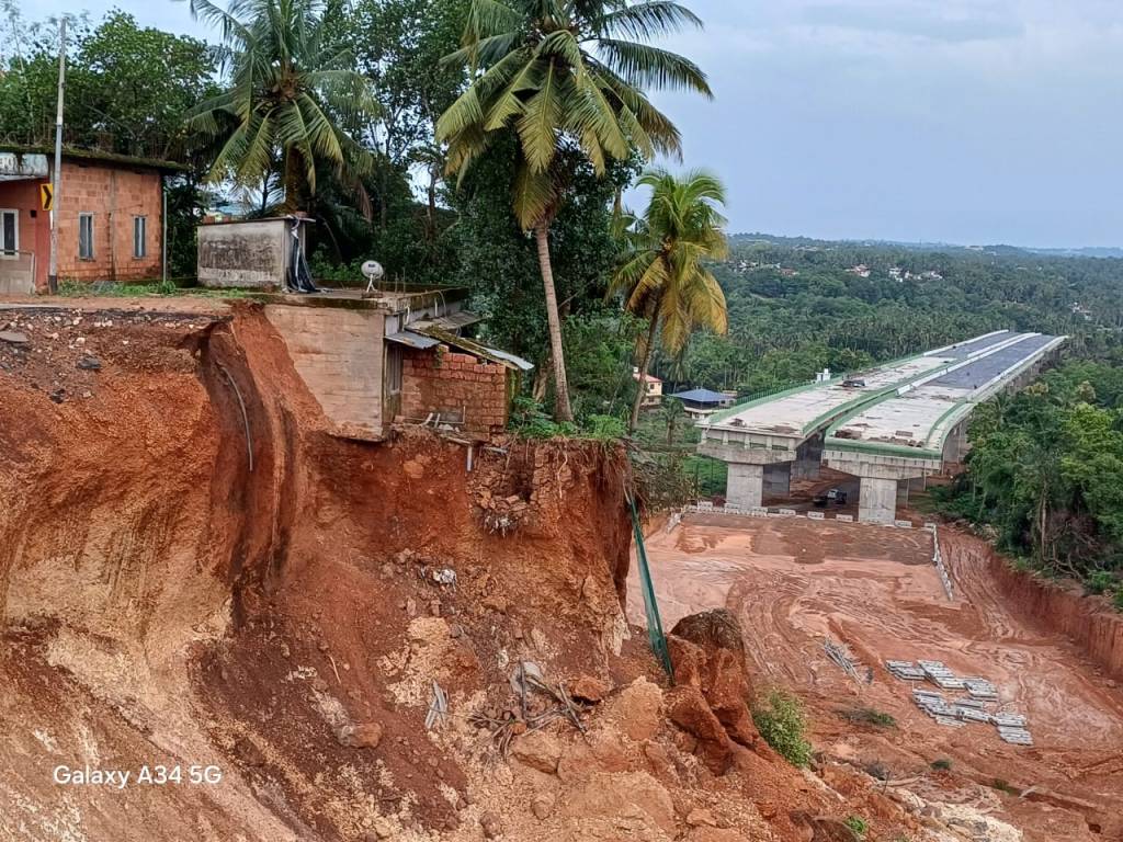
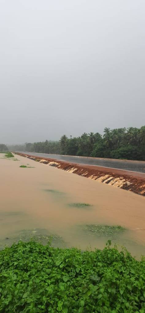
On May 19, 2025, a newly built section of NH66 near Kooriyad in Malappuram cracked open and collapsed. Vehicles fell into pits, lands were waterlogged, and a part of the service road slid into nearby paddy fields. All this happened under normal pre-monsoon showers—not a cloudburst. This highway stretch, built by filling up a paddy wetland and laying asphalt, is one of many similarly vulnerable sections created by NHAI’s shoddy methods.
What collapsed wasn’t just asphalt and concrete, but a delusion: that infrastructure can be imposed on Kerala’s rain-fed slopes, living soils, flowing water, and resistant people. NH66 is not merely a structural failure but an ecological and social rupture. A betrayal.
Now, the land speaks—through floods, fractures, and resistance.

NH66: A Profile in Imposition
Originally NH17, the highway runs along India’s western coastline from Mumbai to Kanyakumari, including parts of NH47, and was renumbered NH66 in 2010. It is a major north-south highway on the western coast of India, stretching from Panvel (near Mumbai) to Kanyakumari. It traverses the states of Maharashtra, Goa, Karnataka, Kerala, and Tamil Nadu. It is undergoing huge upgrade, including expansion to 4 or 6 lane road.
In Kerala, it winds through a densely populated, hydrologically sensitive landscape—crossing rivers, hugging backwaters, cutting through paddy lands, and skirting laterite hillocks. For decades, it was a modest two-lane road, shaped by terrain and closely tied to everyday life in Kerala.
In the mid-2010s, NH66 was chosen for six-laning under the Bharatmala Pariyojana as part of India’s national corridor development program. The 644-km Kerala stretch—from Thalappady to Mukkola—was deliberately sliced into segments under 100 km to bypass full environmental impact assessments. The move allowed the NHAI to avoid public hearings, hydrological and ecological studies, and social audits, which are essential steps for large linear infrastructure.
Construction began in phases starting in 2017 using the Hybrid Annuity Model (HAM) under PPP framework. Under this model, private contractors build and maintain the highway in exchange for government annuities and toll collection, incentivising access-controlled designs—long stretches without entry, grade-separated junctions, toll plazas, and restrictions on slow-moving vehicles and local usage.
Thus, NH66 was reshaped from a public lifeline into a quasi–expressway prioritising fast, long-distance traffic, side-lining the people it once served.
As of now, NH66 remains a corridor under construction. Out of over 620 km, only around 270 km is complete, with the remaining stretches—particularly in Ernakulam, Thrissur, and central Kerala—facing delays. The Union Ministry claims full commissioning by late 2025 or early 2026, but several critical stretches, including the recently collapsed northern sections, remain incomplete, unsafe, or structurally compromised even before opening.

Kerala: A Landscape That Flows
Kerala isn’t just a coastal strip—it’s a dynamic mosaic of moving water. Rain here doesn’t merely fall; we say “mazha peyyunnu” — a verb that captures the rain’s vibrant, ambient presence. The rains then determine the terrain. Soaking the Western Ghats, the water flows westward through forests, hillocks, rivers, paddy fields, streams, canals, wetlands, and backwaters, eventually reaching the Arabian Sea. Along the way, it recharges aquifers, fills reservoirs and lakes, and replenishes over 65 lakh wells that still serve more than 60% of the population.
Even fallow paddy fields act as wetlands, recharge zones, and flood buffers. Communities once lived in harmony with this monsoon rhythm, guided by a deeply rooted hydrological intelligence that evolved over centuries. Today, much of that has faded. Modern aspirations and successive governments pushing an “absolute and blind” development dream have severed this connection. So when NH17 was expanded into a six-lane NH66, few foresaw the consequences—the highway was simply built across Kerala’s east-to-west water pathways, like a dam across the state, blocking surface and subsurface water flow.

NH66: A Wall Across the State
NH66 in Kerala follows a uniform, embankment-based design, borrowed from highway models for semi-arid or plateau regions. This design ignores Kerala’s sloping, monsoon-fed terrain and intricate drainage. In several segments, embankments rise 4–6 meters above land, blocking natural east–west water flow.
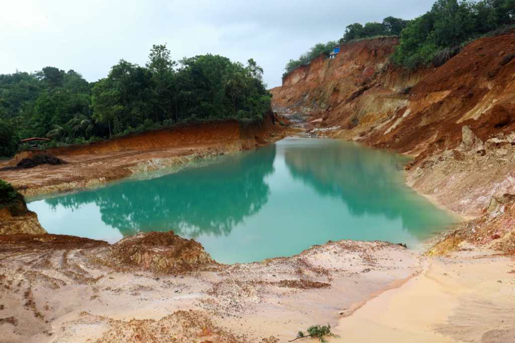
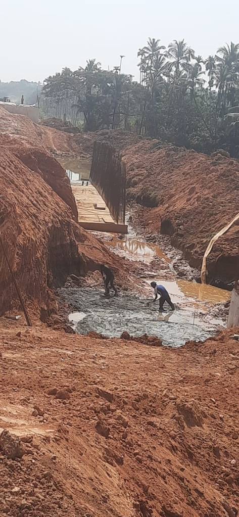
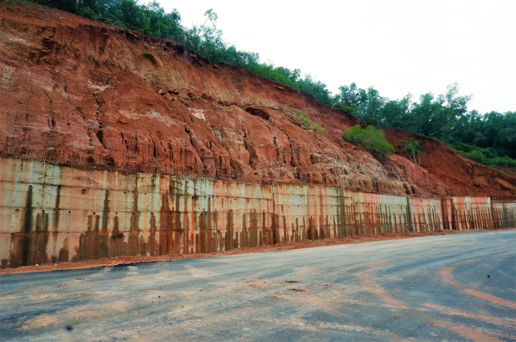
Large tracts of productive paddy and wetlands were filled using laterite and clay mined from hillocks without any slope stabilisation—causing erosion, landslides, and stream disruptions. Across the alignment, culverts, weep holes, and viaducts are grossly inadequate. High embankments often have culverts spaced 800–1,200 meters apart, where Kerala would need one every 100–200 meters. Many are undersized, blocked, or misaligned—rendering them ineffective.
The Kooriyad collapse in Malappuram happened on a segment built by reclaiming paddy land, without subsoil drainage or geotechnical support. Pre-monsoon rain water saturated the foundation, and the embankment collapsed. NHAI blamed the collapse on rain and soil, ignoring that the road design had to consider these even before the Detailed Project report was approved. The collapse was clearly a design failure or a corrupt deviation.
An RTI revealed 74,921 trees were felled for NH66, while only 55,540 saplings have been planted, far from the promised tenfold number. Worse, most were planted in places far off from where it was removed, in Thiruvananthapuram, Kozhikode, and Kasaragod. Such distant planting is ecologically meaningless.
A century-old rain tree or jackfruit by the road offers shade, microclimate balance, and soil protection that remotely planted saplings cannot. Kerala’s monsoon ecology depends on trees lining fields, roads, and water channels, not distant plantations. This violates the Green Highways Policy (2015), which mandates 1% of project cost for greening. Even Highway Minister Nitin Gadkari admitted in 2021 that no Indian highway meets this standard. ‘Not a single highway in India is perfect when it comes to green plantation,’ he said.

People Spoke, They Didn’t Listen
A decade ago, architect G. Shankar and I, as part of the Tree Monitoring Committee in Thiruvananthapuram, inspected the Kazhakuttom–Mukkola NH66 stretch to assess trees marked for felling. What we saw was alarming—a highway carved through Kerala’s terrain with no regard for its hydrology. Massive embankments were rising, blocking natural east–west drainage. Culverts were missing where water traditionally flowed, violating Kerala’s monsoon ecology.
Meanwhile, at Akkulam, a unique Laurie Baker-style Nirmiti Kendra building—the first of its kind—was demolished to flatten a hillock for mining soil for road fill. We joined poet and environmentalist Sugathakumari to file a PIL in the Kerala High Court. The court granted a stay. But that did not stop the project. Pressured by deadlines, the then Chief Secretary and District Collector helped the contractors raze other nearby hills—trading one ecological wound for another.
Our warnings—about blocking hydrological flow and destroying midland hills for soil—were ignored. We were mocked by the officials and contractors and even told we were “anti-development.” But we stood firm. We cautioned that areas like TechnoPark, east of the embankment, would flood. Today, every monsoon floods its ground floor. At Pallipuram, Sankar observes that the Kerala Digital University experiences flooding on the first floor and damp walls extending up to the third floor.
We knew what was coming. And today, the rain and the water are proving us right.
Keezhattoor: Protest Turned Prophecy
In Keezhattoor, Kannur, an NH66 bypass was planned through fertile paddy wetlands—crucial floodplains and aquifer recharge zones. Protesting villagers stood waist-deep in slush and declared, “We are the land. The fields breathe. If you bury them, the water will rise.” Thus began the Vayalkili Samaram (meaning Birds of Paddy Protest), a peaceful, deeply ecological protest. It wasn’t against the road, but against destroying water sources, food systems, and commons.
Environmentalists and social and cultural leaders from across Kerala supported the protest. The Kerala Shastra Sahitya Parishad proposed alternatives like realignment or a viaduct, all of which were contemptuously ignored. Instead, NHAI, backed by the Kerala PWD and state government, pushed the original alignment. To source soil, nearby laterite hillocks were razed, destroying natural catchments and worsening the water crisis.
The protest was vilified as “anti-development.” The ruling party in Kerala, led by the Chief Minister and District party leaders, invoked the narrative of progress to delegitimise the dissent and target village leaders. Protesters were evicted, arrested, and falsely charged. Despite proclaiming their concern for ecology and the threat of floods after 2018, the state government retracted, and became agents of destruction.
Meanwhile, activist Nobel Paikkada took the issue to the National Green Tribunal, which ordered an EIA. In response, the Union Environment Ministry issued a notification in 2017 that exempted highway expansions from Environmental Impact Assessments (EIAs), even in wetlands and ecologically sensitive areas, thereby nullifying the ruling and ending legal resistance.
Today, the bypass sits atop paddy fields that flood even during normal rains. Waterlogging is regular in houses nearby, wells provide stagnant stinking water, and roads have become impassable during every monsoon spell.
The protest was crushed. Alternatives ignored. Warnings buried. But the flood returned—and vindicated the people and the protest.
Across the State, the Pattern Repeats
From Thrissur’s Kole wetlands to Alappuzha’s backwaters, and Kozhikode’s canals to Kollam’s service roads, communities and experts repeatedly raised alarms as NH66 took shape as an elevated highway. They documented blocked field channels, faulty culverts, unscientific embankments, and flooded service roads. In Karivellur, Kalikkadavu, and Pilathara, early monsoons flooded homes—direct results of embankments cutting across streams. In Cheruvathur, mesas (rare laterite tabletop hillocks) were razed for fill, destroying natural slope buffers. Kattampally, Kuttikkol, and Pulluppi Kadavu saw wetlands and mangroves filled, causing water contamination and ecosystem collapse.
Still, local warnings were consistently ignored.
The segmented project design also weakened public resistance, as each district and community grappled with a fragmented understanding of the project plan. While some sections of the project are currently open for traffic, many others remain under construction or have already begun to fail, exhibiting issues such as cracking, collapsing, or flooding.
Across Alappuzha, Kollam, Kozhikode, and Kannur, service roads wash away, cracks appear, and water stagnates in ponds and canals. In Pappinisseri Thuruthi, floodplains are now retention ponds, trapped behind NH66 embankments.
The pattern is clear: a road that blocks water and a system that won’t listen.

A Road That Divides and Excludes
NH66 reveals a deeper injustice—not just how it was built, but who it was built for. While trucks and SUVs cruise the six-lane highway, nearly 80% of Kerala’s road users—two-wheelers, autorickshaws, and tractors—are pushed onto narrow, broken, waterlogged service roads.
Originally, under Bharatmala Pariyojana, NH66 was to be an upgraded public highway suited to Kerala’s terrain, balancing safety and accessibility, and preserving its role as a lifeline for daily mobility. But the design quietly shifted into an elevated limited-access expressway — without public debate, but with silent active approval from the LDF-led state government.
The revised Detailed Project Reports (DPR) introduced alien features: grade-separated junctions instead of intersections, no direct access from homes or shops, and long entry-less stretches, especially in rural areas. Slow-moving vehicles were barred from the highway, forcing them instead onto distant interchanges kilometres away.
This has created a two-tier system: a six-lane, tolled corridor for faster long-distance vehicles, and crude, unsafe, narrow, flood-prone service roads, not even a two-lane, for everyone else.
The shift stems from the Hybrid Annuity Model (HAM), where tolls and annuities repay private contractors. To boost toll revenue, local access was sacrificed. Toll plazas appear every 50–60 km, and a single trip across Kerala may cost over ₹1,650, while locals struggle along crumbling side lanes.
The NH66 has also fractured everyday life across many towns and villages. Entire communities now find themselves split by towering embankments, with homes, farms, and schools cut off from each other. Children walk kilometres to reach once-nearby schools; some schools may shut down altogether due to falling attendance. Small shops and roadside businesses have lost access and customers, with no space for vehicles to stop. Workers and daily commuters—especially two-wheeler and autorickshaw users—must now take long detours, increasing both cost and hardship.
This isn’t just a bad road, a product of incompetence or corruption—it’s mobility apartheid. The government led by Narendra Modi, which claims “Sabka Saath, Sabka Vikas” (development for all), built this highway, while the Pinarayi Vijayan-led “janakeeya sarkar” (people’s government) in Kerala ensured its realisation, with what they claim as “his” will power.
A Field Report Confirms the Crisis
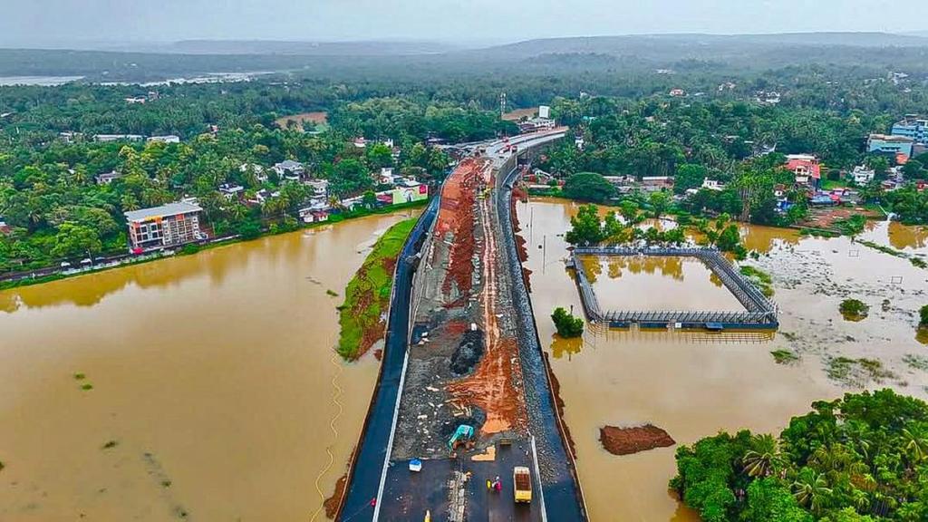
In June 2025, a fact-finding team from the Kannur District Environmental Coordination Committee—including environmentalists, engineers, ex-PWD officials, and activists—surveyed the NH66 Kannur–Kasaragod stretch, now among the state’s worst-hit segments. Their findings were grim. In Karivellur, Pilathara, and Pappinisseri Thuruthi, high embankments without adequate culverts blocked streams, flooding over 10,000 homes during the first monsoon spell. In Cheruvathur, ancient laterite mesas were razed for road fill, destabilising slopes and destroying aquifer recharge zones. In Pulluppi Kadavu, Kattampally, and Kuttikkol, mangroves and paddy wetlands were filled, destroying flood buffers and contaminating water sources.
Across the 44.4 km stretch—Thalappady to Chengala in Kasaragod and Mattanur to Thaliparamba in Kannur—contractors bypassed consultations, and construction began even before drainage surveys were done. Culverts were absent, blocked, or misaligned, and no subsurface drainage was provided, despite known flood risks.
Local engineers confirmed repeated violations of Indian Road Congress (IRC) standards and environmental safeguards. The report concludes: “These are not isolated lapses in construction. They represent structural betrayals of Kerala’s ecological wisdom—executed with the active approval from state and central highway agencies.”
Even before community reports, a 2024 Geological Survey of India study warned of slope instability along the NH66 Kasaragod stretch. It flagged unsafe laterite cuts, blocked drainage, and landslide risks, recommending site-specific engineering and proper slope benching. These warnings were ignored — only to be confirmed by slope collapses and flooding this year.

2018 Floods: Lessons Buried Under Asphalt
We should have learnt from the 2018 floods.
That year’s catastrophic floods killed over 400, displaced thousands, and devastated Kerala’s land and lives. The Post-Disaster Needs Assessment (PDNA) Report, by the Kerala government, UN, ADB, The World Bank, and EU, issued a clear warning that Infrastructure must not obstruct natural water flow and that wetlands and paddy systems must be integrated as critical buffers, not sacrificed for construction. It recommends an Integrated water resources management (IWRM), eco-sensitive and risk-informed approaches to land use and settlements and an inclusive and people centered approach, with the two themes of ‘room for the river’ and ‘living with the water’. This was the original recovery strategy for the now much hyped Chief Ministers “Nava Keralam’ (New Kerala) campaign.
This was echoed at the 2020 Nammal Namukkayi workshop, where planners, scientists, and citizens recommended:
“Ensure that the East-West surface hydrology is not curtailed by North-South constructions (roads, railway lines)”
Yet, within a year, these lessons were buried under concrete. NH66, with high embankments and uniform design, defies all of them—slicing across drainage paths, filling paddy fields, and raising flood risks across districts. This isn’t just poor planning; it’s a deliberate erasure of flood memory.
While NHAI built this ecological offence, the Kerala government enabled it. The once-progressive Paddy Land and Wetland Act, 2008 was diluted despite the lessons from the flood. The government promoted the conversion of paddy lands for projects like NH66, which directly contradicted the lessons learnt from the floods. The PWD, instead of protecting Kerala’s hydrology, were complicit.
NH66 now stands as a monument to institutional forgetting.

SilverLine Was Stopped. NH66 was not. Why?
The contrast is stark. SilverLine, Kerala’s semi-high-speed rail proposal, envisioned a 529 km elevated corridor from Thiruvananthapuram to Kasaragod. Though branded “green transport,” it planned high embankments across villages, farmlands, wetlands, and water channels, triggering fears of massive displacement and ecological harm. The project drew sharp criticism for its high embankment design, and for the lack of flood mapping, safeguards, and displacement planning.
Like NH66, SilverLine would have blocked Kerala’s east–west water flow, disrupting streams, paddy fields, and drainage systems. Experts warned that the project would intensify flooding and damage Kerala’s hydrological balance, particularly during the monsoon season.
But this time, public resistance worked. Citizens protested, engineers and activists spoke out, the media questioned it, and legal challenges were filed. The debate grew—and SilverLine was shelved, at least for now.
NH66, by contrast, slipped through. Built in fragments, tendered without public scrutiny, and justified with national templates, it faced no state-wide hearings or cumulative EIA. Each district or community saw only a small part of the project—never the complete picture. In contrast, unlike SilverLine, NH66 had bipartisan political backing as a symbol of development. Even local resistance—like Keezhattoor—was isolated and suppressed.
Both projects shared a fatal flaw: ignoring terrain, water, and people. But only one faced public reckoning. The other now collapses under the weight of that very denial.
Not Just a Kerala Story: A National Template of Failures
What’s unfolding in Kerala is part of a broader national pattern—infrastructure built with little regard for terrain, hydrology, or resilience.
In Uttarakhand, the Char Dham Highway has triggered landslides and slope failures along unstable Himalayan slopes, just as geologists warned. That project too avoided EIA and Scrutiny by breaking the project into smaller parcels. In Maharashtra, cracks and subsidence plague the Mumbai–Nagpur Samruddhi Expressway, especially along elevated concrete sections and underpasses, with a 200-meter ramp on NH-548C flooding after just 107 mm of rain in June 2025. Earlier, a newly laid stretch near Shahapur cracked before opening. In Tamil Nadu, NH32 repeatedly fails during monsoons, with poor drainage and ignored slope logic. In Himachal Pradesh, the High Court has passed repeated strictures against NHAI for dumping muck into rivers. NHAI here has been blamed for creating man-made disaster from natural floods in 2023 and again in 2025.
These failures echo the findings of the 2023 CAG audit, which identified serious design and execution flaws in highway projects, including projects awarded without valid DPRs or proper design approvals. It highlighted unjustified cost escalations, resulting from flawed planning. Many stretches faced delays and design changes mid-construction, exposing systemic lapses in project execution, making roads not just ecological hazards but unsafe as well. Union Minister Nitin Gadkari continues to hold strong opinions that “faulty DPRs and poor road designs” are key causes for the rising road accidents. Even so, it is worrying that no serious corrections are being made.
The Indian Roads Congress (IRC)—the apex body for road design—offers terrain-sensitive guidelines for culvert spacing, slope protection, and floodplain integration, but these are often bypassed by standardised templates. The NH66 in Kerala, similar to roads in Uttarakhand, Himachal Pradesh, Maharashtra, and Tamil Nadu, has been transformed into an ecological dam due to its raised embankments, minimal cross-drainage, and minimal slope adaptation.
In both the Kerala and Uttarakhand floods of late 2021, experts had clearly warned about extreme rainfall in the Ghats and Himalayas – forecasts that are tragically ignored. Neither region is prepared to mitigate the impact, and the governments in these states continue to champion unsustainable projects – like elevated highways and dams – dangerously altering natural drainage systems and slopes. A SANDRP report underscores how linear infrastructure against hydrology makes these landscapes disaster-prone – “inappropriate interventions in the name of development are continuously increasing the disaster potential of vulnerable areas”. The report states that “all development projects and plans that are increasing the vulnerabilities by destruction of ecology and land use change should be reviewed and reversed.”
The collapse at Kooriyad in May 2025 should have prompted a call for reform. Instead, NHAI conducted a token internal review, and found that “inability of the foundation soil to support the high embankment” was the cause of the collapse. It took token actions – blacklisted the contractor, suspended its official, set up an inquiry, and issued patchwork repairs. The IMD data of those days showed rainfall was normal. The issue wasn’t the rain after all—it was the road. It should have been designed and built even to weather rainfall and water seepages, but built as an embankment over a wetland, this road will never stand the water. Nobody raised that question.
Worse, the Kerala government remained silent. There was no inquiry, no expert panel, and no accountability. In a state haunted by the memory of the 2018 floods, this silence wasn’t passive or oversight—it was complicity. Kooriyad didn’t just collapse due to the rain; it fell victim to institutional failure. This is now the model: build fast, fail quietly, forget everything—except collecting tolls.
What Must Be Done: Eight Urgent Actions Kerala Must Take
To recover from the damage and prevent future disasters, Kerala must act on both immediate repairs and long-term reforms rooted in its water-wise heritage.
Immediate Corrective Actions
1. Commission Independent, Multi-Disciplinary Audits
Appoint a technical and ecological audit team, involving institutions like ATREE, IITs, IISc, and local hydrologists, to conduct Environment Impact Assessment of NH66, prepare Environment and Social Management Plan, assess flood risk, drainage, structural flaws, and contractor violations. Make findings public, hold public consultations in all affected districts.
2. Restore Drainage and Water Flow
Install missing culverts and weep holes, unblock and realign others, and replace embankments with viaducts in paddy and flood zones. Reconnect streams and provide subsurface drainage where aquifers or seasonal flows are blocked.
3. Restore the NH66 for all public access
Roads and Highways are Kerala’s lifeline with its high density of population and low land availability for infrastructure. NH66 was one such lifeline. It should be restored for all vehicles.
4. Stop Toll Collection on Unsafe or Incomplete stretches.
Halt toll collection on broken, flood-prone, or incomplete roads, including service roads. No toll should be collected until the highway and service roads are usable, culverts cleared, and structural safety ensured.
Structural Reforms for a Water-Wise Future
5. Redesign Roads/ Railways for Kerala’s Terrain
Eliminate the use of universally applicable highway designs. Kerala’s roads must reflect its monsoon climate, sloping terrain, wetlands, laterite soils, and dense settlements. The IRC allows for these adaptations, and Kerala must enforce them. Replace all embankments with viaducts and bridges-on-pillars.
6. Reinstate and Strengthen Wetland and Paddy Land protections.
Undo the dilution of the Paddy Land and Wetland Act. Reinstate its full protective provisions. Recognise paddy fields, wetlands, and canals as vital ecological infrastructure—not wastelands.
7. Enforce Accountability on Contractors and Officials
Penalise contractors for violating drainage or slope standards, and blacklist repeat offenders. Officials who enabled violations or neglected oversight must also be held accountable.
8. Make Planning Transparent and Participatory
Mandate public hearings, release DPRs and flood data, and enable local monitoring of construction impacts. Communities must have a say in decisions that affect their land and water.
Conclusion: The Monsoon, Land, and Water Have Spoken. Will We Listen Now?
Kerala has always lived with water. Its paddy fields, streams, slopes, and backwaters speak a grammar of rain—a logic refined over centuries, etched into the land and held by its people. But today’s infrastructure is not only forgetting that logic; it is actively bulldozing it.
Projects like NH66 defy ecological principles and betray the local population by erasing their knowledge, displacing justice, tearing down the social fabric, and severing the state from its hydrological memory.
Let NH66 not be another silent scar. Let it serve as a poignant reminder, etched in the form of embankments, floodlines, and shattered trust, because water doesn’t forget—and in Kerala, we know that better than most. And when the water returns, it reclaims more than just land; it also uncovers the truths and injustices that we tried to bury.
Sridhar Radhakrishnan (sridhar.keralam@gmail.com) is an environmental and social justice activist. He writes about democracy, ecology, agriculture, and climate concerns.


References
- Indian Road Congress Manuals and Guidelines (https://www.irc.nic.in/)
- MoRTH, GoI Website for various guidelines and specifications and notifications (2016-2020) – Ministry of Road Transport & Highways (https://morth.nic.in/en)
- Kannur District Environmental Coordination Committee (June 2025)– REPORT ON THE RECONNAISANCE SURVEY CARRIED OUT BY THE FACT-FINDING TEAM ON NH66 ALONG THE KARYANGODE-KANNUR STRETCH,
- Geological Survey of India (September 2024) , A NOTE ON PRELIMINARY ASSESSMENT OF CUTSLOPE FAILURES ALONG NH-66 ROAD CORRIDOR ALONG NH- 66 BEVINCHE TO THEKKIL AND VEERAMALAKUNNU TO MATTALAI AREAS, KASARAGOD DISTRICT, KERALA.
- Cover Story by E Unnikrishnan in Mathrubhumi Weekly (June 2025), Nedumpaathayude Bhoomijathakam.
- The New Indian Express (May 29, 2025) – “74,921 trees felled for NH66 development in Kerala; replacement slow” (https://www.newindianexpress.com/states/kerala/2025/May/29/74921-trees-felled-for-nh66-development-in-kerala-replacement-slow)
- PIL Filed by Sugathakumari, G. Shankar, and Sridhar Radhakrishnan (2014) – On the demolition of Akkulam hill and Nirmiti Kendra for road fill in NH66 construction.
- Paikada, Nobel C. v. Union of India (2018–2020) – PIL in the Kerala High Court challenging the EIA exemption for the Keezhattoor NH66 bypass (https://www.casemine.com/judgement/in/6346154cd5f9b52b6e9eca5a)
- Government of Kerala, UN, ADB, The World Bank and EU (August 2018) – Kerala- Post Disaster Needs Assessment – Floods and Landslides (https://www.undp.org/sites/g/files/zskgke326/files/publications/PDNA_Kerala_India.pdf)
- Government of Kerala (January 2020) – Technical Stakeholder Consultation as part of ‘Nammal Namukkayi’ Programme, RKI , (https://sdma.kerala.gov.in/wp-content/uploads/2020/10/RKI-report_Technical-Stakeholders-Consultation_for-PDF-for-Website.pdf)
- SANDRP (October, 2021), Kerala and Uttarakhand floods in Oct 2021: Did the forewarnings help?. (https://sandrp.in/2021/10/26/kerala-and-uttarakhand-floods-did-the-forewarnings-help/)
- Money Control (August, 2023) , CAG flags irregularities in projects under Bharatmala Pariyojana Phase-I, cost overruns in Dwarka Expressway, (https://www.moneycontrol.com/news/business/cag-flags-irregularities-in-awarding-projects-under-bharatmala-pariyojana-phase-i-cost-overruns-in-dwarka-expressway-project-11180881.html)
- Business Standard (March 2025) , Gadkari blames poor road designs, faulty DPRs for rising accidents in India,. (https://www.business-standard.com/india-news/gadkari-blames-poor-road-designs-faulty-dprs-for-rising-accidents-in-india-125030600894_1.html)
- MORTH, Government of India Circular (9th Feb 2016) , Hybrid Annuity Model (HAM) for implementing Highway Projects, (https://morth.nic.in/sites/default/files/implementing.pdf)
- 15. Mongabay (28, April, 2018 ) , Keezhattur farmers want the highway to bypass their paddy fields and wetlands, (https://india.mongabay.com/2018/04/keezhattur-farmers-want-the-highway-to-bypass-their-paddy-fields-and-wetlands/)
- 16. Various News Reports (2017–2025) – Coverage in The Hindu, Indian Express, Manorama, The News Minute, and Mathrubhumi on NH66 construction, tolling, public resistance, and ecological impacts.
- 17. Mid-Day (April 2025) – Cracks Before Cars: Samruddhi Highway Raises Quality Concerns. (https://www.mid-day.com/mumbai/mumbai-news/article/mumbai-cracks-before-cars-samruddhi-highway-stretch-raises-quality-concerns-23511249)
- 18. MORTH, GoI (2015) – Green Highways. (https://morth.nic.in/print/1704)
- 19. The Times of India (May 27,2021) , Not a single highway road is perfect when it comes to green plantation : Gadkari. (https://timesofindia.indiatimes.com/auto/news/not-a-single-highway-road-is-perfect-when-it-comes-to-green-plantation-gadkari/articleshow/82998581.cms)
- The News Minute (4, January 2022) Kerala’s SilverLine rail is economically unviable and threatens ecosystem – Sridhar Radhakrishnan. (https://www.thenewsminute.com/kerala/kerala-s-silverline-rail-economically-unviable-and-threatens-ecosystem-159475)

One thought on “NH66 in Kerala: Built Against Water logic, Designed to Collapse?”