Tripura is facing one of its worst floods, possibly worst since 1983, affecting all districts, at least since 19th August. South Tripura, Gomati and Unakoti are worst affected districts. According to latest estimates, at least 24 people have lost life with two more missing, 65400 people are in 450 relief camps, landslips at 2032 locations, 1.25 lakh ha crops submerged among other extensive damage. Total of around 1.7 million people or about 40% of state pulation are affected. 3 columns of army, 11 NDRF & 26 SDRF teams, 4 MI 17 helicopters and other emergency service teams are involved in rescue and relief works. The actual rainfall that started on Aug 19 gave enough warning for the state to prepare for the approaching disaster, but once again disaster management has failed to respond using this warning.
Downstream Bangladesh also faced massive floods, for good reports on that, see: https://bdnews24.com/bangladesh/d22c69c8d04a and https://www.nytimes.com/2024/08/23/world/asia/bangladesh-deadly-floods.html.
INTENSE RAINFALL The high intensity of rainfall in Tripura can be seen from the following figures for rainfall reported by India Meteorological Department’s (IMD) daily district wise bulletin for respective dates (till 0830 am on respective dates).
| District/ State | Rainfall, mm | |||
| Aug 20 | Aug 21 | Aug 22 | Aug 20-22 | |
| Dhalai | 191.6 | 74.2 | 115.7 | 381.5 |
| Gomati | 232.1 | 57.2 | 45 | 334.3 |
| Khowai | 170.7 | 71.7 | 138.1 | 380.5 |
| N Tripura | 102.9 | 43.6 | 44.4 | 190.9 |
| Sipahijala | 115.9 | 30 | 100.5 | 246.4 |
| S Tripura | 261.6 | 67.6 | 315.3 | 644.5 |
| Unakoti | 119.3 | 32.2 | 46 | 197.5 |
| W Tripura | 128.9 | 112.3 | 149 | 390.2 |
| TRIPURA | 176.2 (1344%) | 63 (523%) | 124.5 (1224%) | 363.7 (872%) |
It is clear from the above figures that rainfall during three days of Aug 20-22 that started from 8.30 am on Aug 19 provided enough advance information for the state and central authorities to prepare for the impending flood disaster even if we do not consider the IMD forecasts. In fact the intense rainfall in South Tripura dist, that got the highest rainfall among all 8 districts of Tripura during this period, actually started on Aug 18 as IMD reported rainfall of 51.7 mm for this district on Aug 19. This means at least for South Tripura the warning bells should have rung starting Aug 18. But from the way situation has panned out, it is clear that the state or the central agencies were caught totally unawares till the floods hit the state from Aug 21 and 22.
Will the agencies start to take cognizance of the actual rainfall (and not only some general forecasts) and prepare for the impending disasters from now on?
See Ravish Kumar show on the floods: https://www.youtube.com/watch?v=YSYnTV7ERcc
Rivers in spate: CWC Flood Forecasting? River water levels are above the HFL (Highest Flood Level) or Danger level in South Tripura, Sepahijala, West Tripura, Dhalai, Unakoti, Gomati, North Tripura and Khowai districts. According to CWC’s flood forecasting department:
- HFL CROSSED: For example, Haora river at Haora in W Tripura district crossed the HFL of 12.4 m (attained on Aug 11 2017) and reached 12.42 m at 0400-0700 hrs on Aug 22.

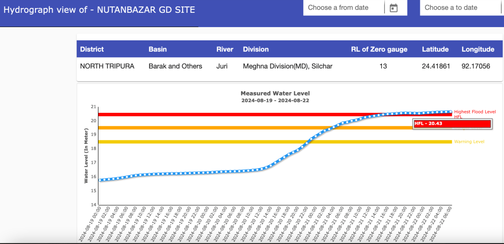
- Juri river at Nutan Bazar in N Tripura district crossed the HFL of 20.435 m and reached new HFL of 20.66 m at 0700-0800 hrs on Aug 22.
- At Belonia in S Tripura district, Muhari river crossed the HFL of 17.32 m and reached new high of 18.81 m at 0700 hrs on Aug 22.

- Within 0.5 m of HFL At Amarpur site in Gomati dist, Gumti river reached 32.62 m at 0600 hrs on Aug 23, compared to HFL of 32.74 m.

- At Sonamura site in Sepahijala dist, Gumti river reached 14.27 m at 0900-1000 hrs on Aug 23 compared to HFL of 14.43 m.

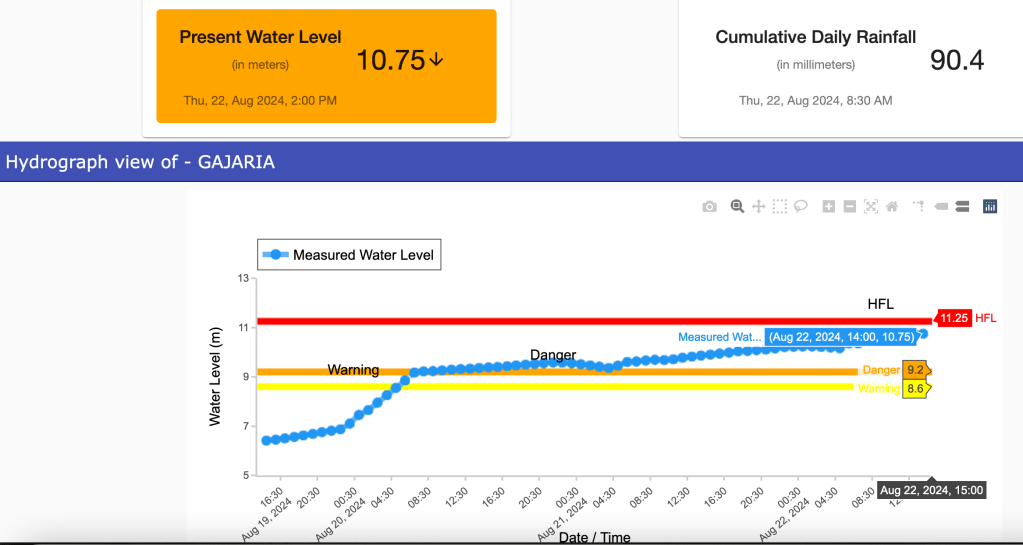
- At Gajaria in Sepahijala dist, Burima river reached 10.77 m at 1300 hrs on Aug 22 compared to HFL of. 11.25 m.
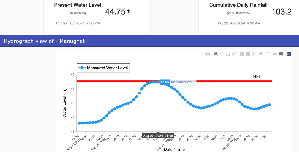
- At Manughat in Unakoti dist, Manu river reached 47.96 m at 1900-2100 hrs on Aug 20, compared to HFL of 48.04 m.
However, glaringly, the Dumbur or Gumti dam, the biggest dam of Tripura, is not part of CWC’s flood forecasting. Even among the sites that are listed on CWC’s flood forecasting in Tripura, a number of sites are not even working. Even for the Amarpur site on Gumti river that is part of India-Bangladesh agreement for flood information sharing, the site did not function between 1600 hrs on Aug 21 and 0600 hrs on Aug 23, the most crucial flood period, when the site is likely to have crossed the HFL. The Sonamura-2, Feni, Sabrum, Kadamtala and Manughat are some of the sites which are either not functioning or crucial information is missing.
Dumbur Dam: Why no advance water release action? Dumbur or Gumti dam located in the Gandatwisa sub-division and Dhalai district of Tripura is the biggest dam of the state with 30 m height and 103 m length. Spillway capacity is 481.38 cumecs. Reservoir area is 0.709 sq km as per CWC’s National Register of Large Dams dated Sept 2023. As per the Tripura State Electricity Corporation Ltd website[i], Gumti is a 15 MW project with the third 5 MW unit commissioned in 1984 and first two in 1976. It says: “The yearly energy content in the reservoir of Gumti project is only 60 Million units. Normally 2 units of 5MW each run at a continuous load of 8 MW and the 3rd one is kept as stand by.” The Gumti reservoir Minimum Draw Down Level is 83.6 m and FRL 93.55 m (energy content 85 Million Units (MU)). So this huge dam with massive reservoir area is supposed to be producing just 8 MW power.
According to North East Region Load Despatch Centre website’s daily power supply position report[ii] Gumti HEP generated no power on Aug 22. The reservoir level on Aug 21 was 92.7, on Aug 16-20, around 92.5 m. Strangely, the reservoir level was shown “Zero” on Aug 22 and 23 which clearly seems wrong. The website says Gumti HEP generated no power on Aug 21, 22. On Aug 20 it generated 0.01 MU, during Aug 16-19 0.05 MU daily. So even in peak monsoon months with high water flow in the river, the dam was not generating almost any power. Why was the project not generating power at full capacity during these days? Why was the reservoir storing so much water in that case?
Contradicting NERLDC about zero storage on Aug 22-23, the Central Water Commission’s weekly reservoir Bulleting for Aug 22, 2024[iii] showed that Gumti Reservoir had water level at 92.6 m, equal to live storage of 0.268 BCM (Billion Cubic Meters), that is 86% of live storage (out of 0.312 BCM at FRL) on Aug 22 2024.
Leaving aside the controversy about claim of Bangladesh that Dumbur dam releases brought floods in Bangladesh, the first question that arises is why did the dam not start releasing water starting from Aug 19 morning when dam was almost full and high rainfall had already started? Here we are not talking about action based on rainfall forecast, but based on actual rainfall in the catchment, which is surely going to end up in the river and reservoir. The claim of the project operators to media that the gates automatically operate when water reaches FRL and they cannot operate the gates manually is clearly wrong, the option of manual operation of gates is always available for safety of the dam.
It could have started releasing water from Aug 19 (& operating power units at full capacity if that was technically feasible) taking into account the downstream river carrying capacity and expected inflows into the dam based on the rainfall that was already happening in the catchment, for which it must be getting hourly data. That could have helped provide at least a few hours (it can be even few days depending on the extent of advance action) of respite to the downstream area. These hours could have been used to alert and prepare the downstream area and evacuate people at risk. It would have helped Tripura too since the river travels 120 km downstream of the Dumbur in Tripura before it enters Bangladesh.
India to Bangladesh: Floods not due to Dumbur India’s Ministry of External Affairs clarified on Aug 22 2024 through a Press Statement[iv]: “We have seen concerns being expressed in Bangladesh that the current situation of flood in districts on the eastern borders of Bangladesh has been caused by opening of the Dumbur dam upstream of the Gumti River in Tripura. This is factually not correct. We would like to point out that the catchment areas of Gumti river that flows through India and Bangladesh have witnessed heaviest rains of this year over the last few days. The flood in Bangladesh is primarily due to waters from these large catchments downstream of the dam.” While this is correct, if we had taken advance action of water release from Dumbur dam taking the high rainfall already happening, it would have helped both countries. Particularly when the dam is not even producing any significant amount of power.
Information about the disaster The FB page of Tripura Disaster Management Authority[v] has not been updated since Aug 16 as we write this.
Tripura Disaster Management Authority website[vi] provided no updates about the flood disaster till Aug 23 as we write this. Even on TDMA’s official facebook page[vii], there is no update regarding the disaster except one post with 3 photos on Aug 22. However, there are more updates about this disaster on Tripura Govt’s FB page[viii], however, large number of them are focussed on the visits of the Chief Minister Dr Manik Saha rather on the flood situation.
However, interestingly, the FB page of Gomati district magistrate had frequent and useful updates about developing flood situation in the district, some of them are given below.
On Aug 20 2024, 6.19 PM, Gomati District Magistrate conveyed “Dumbur Dam Alert” on FB[ix]: “Water from Dumbur Hydroelectric Project Dam has to be released as water has accumulated to the critical level giving no scope to TPGL but to release some water. Requesting all citizens concerned and downstream Districts of the state to take precautionary measures immediately.” As the FB page says, this is the “Official Facebook Page of District Administration, Gomati District, Udaipur”. This also shows that Dumbur dam had such high storage, while it was not even producing much power. This storage, particularly in view of heavy rainfall is clearly in violation of the rule curve and prudent dam operation.
Alert at 5 pm, Aug 21 2024: “Two nos. Flap gates fully & one gate partially (50%) (automatically) discharging water from reservoir.” At 8:35 am of 21st August: One flap gate (out of 3) have been opened.
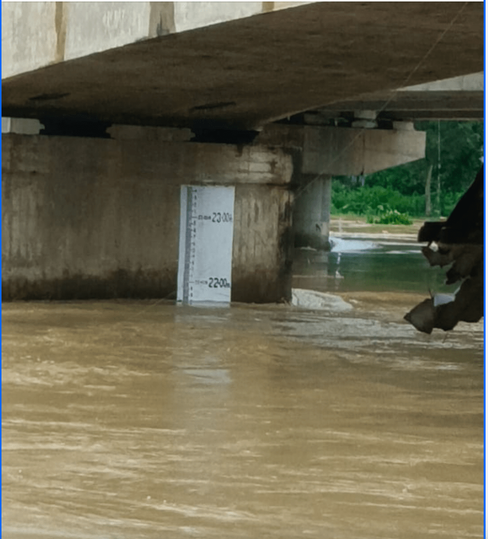
14.45 hrs, Aug 21 2024: Water Level of Gomati River at Udaipur Gauge Station (near Subhash Bridge): Extreme Danger Level crossed in the afternoon today. Extreme Danger level: 22.00 m – Present level: 22.05 m (Time: 14.45 hours); 21.9 m at 10.30 hrs; 21.8 m at 0945 hrs; 21.7 m at 0825 hrs.
Water level of Gomati river at Amarpur gauge station (near Rangamati bridge): Extreme Danger level= 32.00 m – Present water level at 8 am on Aug 22: 31.94m
Climate Change Preparedness? While it is known that climate change is going to bring such intense rainfall event with greater frequency, it is clear that the states and their disaster management authorities as also the central agencies are ill prepared to face the reality. As Indian Express[x] noted: “Tripura’s climate action plan, for instance, has only a few sentences on floods and landslides… The state’s farm sector is yet to recover from the damage caused by Cyclone Remal in May and another round of floods a month later.” Even what is written state climate action plan is hardly implemented.
Many questions, but will we improve our disaster management? Many questions have been raised here about the disaster management during the current Tripura flood disaster. The question is are we doing anything to address these issues and improve our disaster management? This becomes pertinent when we realise the increasing frequency of high intensity rainfall events and extreme flood situations we are increasingly facing. These questions are relevant for Dumbur dam, but also for the disaster management across the state.
The government need to immediately institute an independent inquiry into the flood disaster to understand and document what happened, who played what role, who was responsible, what lessons we can learn for future. The CWC should be directed to bring Dumbur dam into its flood forecasting. The Rule curve of the Dumbur dam should be reviewed. Reasons for its high storage when so little power is being produced investigated. Also investigate their claim that the dam gates cannot be operated manually.
IMD should be providing river basin wise rainfall information on hourly basis when rainfall crosses say 50 mm in a day or less. The disaster management authorities should have SOP that says that the disaster action plan everywhere should start based on the actual rainfall in the catchment.
If we want to improve our disaster management these steps need to be urgently taken.
SANDRP (ht.sandrp@gmail.com)
POST SCRIPT:
1. Additional issues with CWC Flood Forecasting in Tripura:
1 Feni G&D Site in South Tripura district: No river name and No HFL details
2 Sonamura II site on Gumti river in Sipahijala district: No HFL details
3 Sonamura site on Gumti river in Sipahijala district: No HFL date
4 Kadamtala site on Juri river in North Tripura district: No HFL details
5 Kailashahar site on Manu river in Unakoti district: Site is inactive
6 Sabrum site on Muhari river in South Tripura district: No HFL details
7 Manughat site on Manu river in Unakoti district: CWC corrected HFL to 18.04 meter dated 12.06.2018 after SANDRP raised this. CWC wrongly showed 46.97 meter HFL dated 16.06.1993.
8 Belonia site Muhari river in South Tripura district: Against SOP CWC updated HFL 17.32 meter attained on 02.08.2024. (Old HFL 16.98 meter dated 04.08.1993). River has touched peak of 18.12 meter on 20.08.2024 and 18.81 meter on 22.08.2024. (But these peak not updated, neither 17.32 meter HFL has been removed) Its an old site under CWC observation for over past forty years and HFL should be updated at the end of flood season as per CWC SOP.
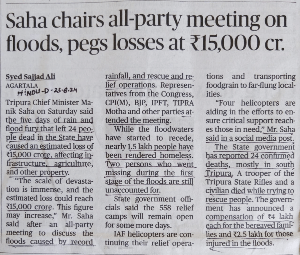
POST SCRIPT 2: According to Chief Minister, total lost during the floods is estimated at Rs 15000 Cr.

[i] https://www.tsecl.in/Generation.html
[iii] https://cwc.gov.in/file/41250/download?token=BQWl4uFZ
[iv] https://www.mea.gov.in/press-releases.htm?dtl/38197/Flood_situation_in_Bangladesh_not_due_to_release_of_waters_from_Indian_dam_on_Gumti_River_Tripura
[v] https://www.facebook.com/profile.php?id=100068132364259
[vi] https://tdma.tripura.gov.in/
[vii] https://www.facebook.com/profile.php?id=100068132364259
[viii] https://www.facebook.com/mygovtripuraofficial
[ix] https://www.facebook.com/share/p/bdTs4v1qocrmgTxm/?mibextid=oFDknk
[x] https://indianexpress.com/article/opinion/editorials/tripura-floods-agartala-9528229/
