(Feature Image: a picture of Tawi Riverfront and Real Estate Development uploaded on Jammu Smart City website)
Tawi Riverfront Development (RFD) project in Jammu symbolizes the fallacy of most of the RFD projects in India. The city owes its historical relevance, cultural legacy and gradual prosperity to the river. But in return the Tawi has been witnessing typical urban river problems of gradual decline in flows, continual rise in solid and liquid waste pollution, encroachments and riverbed mining. And as is the case with most of urban rivers, instead of taking effective measures to address the existing threats, the government here has been pumping crores of rupees into an artificial lake and RFD project for over past one and half decade in a non-transparent and questionable manner.
From Artificial Lake to RFD Project: A Mysterious Journey
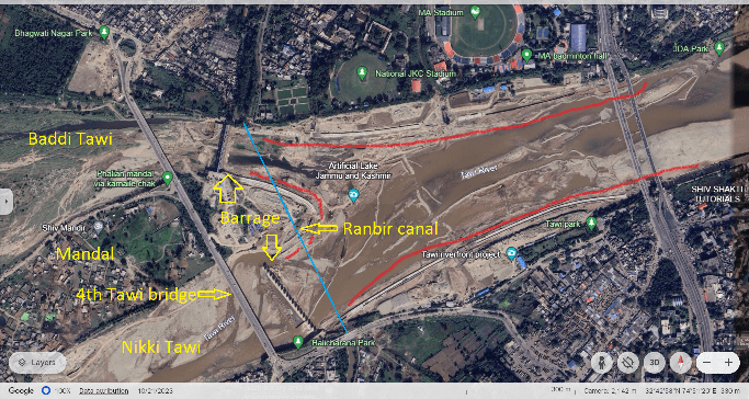
While passing through the heart of Jammu city, the Tawi river bifurcates into two separate channels Nikki (Small) and Baddi (Big) Tawi forming a huge river island called Mandal. Originally, there was a plan to create an artificial lake by building two barrages at the mouth of these channels separating Bhagwati Nagar and Belicharana.

The main objectives were to facilitate groundwater recharge in Kandi belt, to get 120 cusec irrigation water for Chatha, Tawi island villages and to make Jammu an independent tourist destination. The project also had components to beautify riverbanks, implement flood control action plan and divert sewage drains polluting Tawi river in Jammu.
The project was approved in 1986 by Governor Jagmohan with an estimated cost of around Rs. 23 crore. The project saw no progress on ground for the next two decades. It was taken up again during Gulam Nabi Azad rule’s in 2006-08. The foundation stone was laid in Dec 2009 by then CM Omar Abdullah. By that time, it became a central government sponsored project with 90:10 (centre: state) funding ratio and the cost went up to Rs. 69.70 crore.
Local people aware of the matter even stated that the project site has been changed many times from Nagrota to Nikki Tawi stretch to location between Bahu Fort and Sidhra Bridge in 2008 and then to area covering Bhagwati Nagar to Gujjar Nagar bridge stretch where the work actually started in 2010. There are allegations that the present location was selected because of some influential politicians owning properties there who anticipated it as good opportunity to increase land value.
Initially, the work was to be completed in 2 years. But next one year was lost in the drawing, designing and consultancy and the actual work started in July 2010. Since then, the project has faced repeated delays and cost escalation. It first missed July 2012 deadline and subsequently over half a dozen new deadlines including July 2013, December 2013, March 2014, June 2015, March 2016, January 2018, April 2018, December 2018, April 2023 and February 2024. In the past 15 years the government has already spent over Rs. 58.19 crore on the project. Cost has further been increased to about Rs. 130 crore, however the work is far from completion.
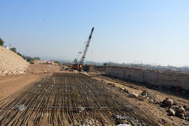
Tawi Barrage
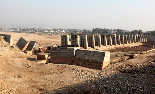
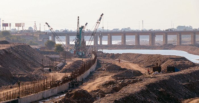
Construction of two Auto-mechanically Operated Gated Barrages (AMOGB) on Nikki and Baddi Tawi channels is one of the important components of Tawi artificial lake project. The barrages in total have 31 gates and are 370 meter long. The gates were planned to be 4 meters wide and 10 meters in height. The barrages would create about 1.5 km long and 600 meters wide water body of 1.1 Thousand acre feet capacity.
The Irrigation and Flood Control (I&FC) Department, Jammu was in charge to implement the plan and Hyderabad based GVR Infra Project Limited was given contract to build it. As per the reports, all the piers of 11 gated and 130 meters long barrage on Baddi Tawi have been built. One of 20 gated pier structure of 240 meters long barrage on Nikki Tawi remained to be built.
Politics, Floods & Losses
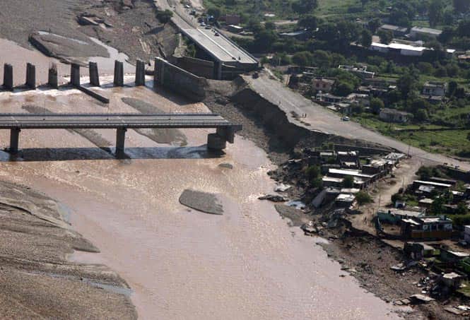
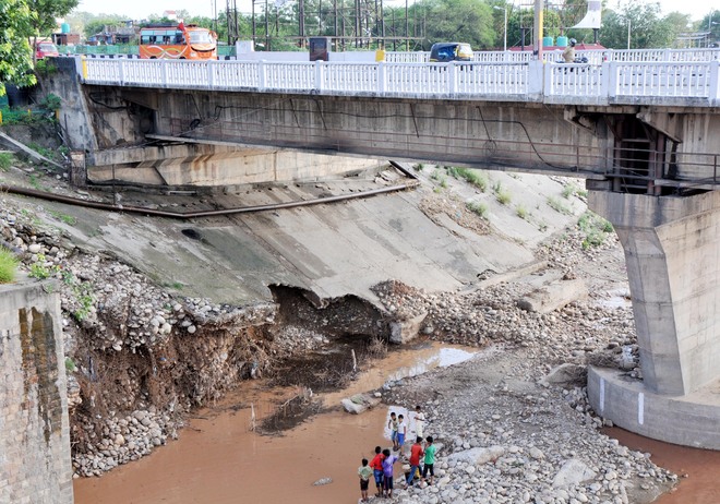
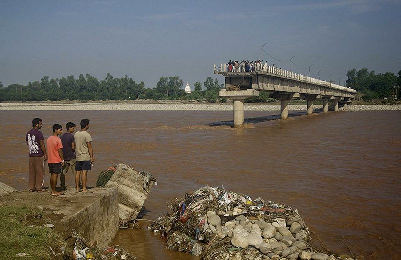
The project reportedly faced delays due to slow release of funds and interdepartmental issues. The Sept 2014 floods significantly affected the project. Some of the piers of barrage on Nikki Tawi side were damaged by the floods causing financial losses to GVK Infra Limited further slowing down the work. The protection bund of the project was breached in Aug. 2016 floods impacting the progress. Subsequently, the company left the work unfinished in February 2018.
Following this, Irrigation and Flood Control (I&FC) served several notices to the company asking it to resume the remaining work but in vain. In a meeting with the company officials in May 2018, Sham Lal Choudhary, Minister, I&FC even warned the company officials to resume the work within a week or face legal notice, tender termination and seizure of project machinery and apparatus.
Despite this, GVK Infra Limited could not resume the work and its contract was terminated in June 2018. However, the company challenged the decision in Madras High Court and the Court in December 2018 vacated the interim injunction regarding termination of contract paying way for retendering of the project.
The artificial lake project was moving at snail’s pace since the beginning. Then the change in central (NDA) and state government (BJP-PDP coalition) in 2014-15 reportedly brought changes in the project design.
In most interesting development on May 15, 2015, the PDP CM Mufti Mohammad Sayeed in presence of Deputy CM Dr. Nirmal Singh from BJP publicly decided to scrap the lake project terming it economically and technically unfeasible. He further stated that the Tawi is different from Chenab and Ravi rivers and the project will be silted up in a year.
However, the Deputy CM approached Uma Bharati, Union Water Resources Minister the very next day seeking Central support for the project. The PHE Minister Sukhnanadan Chaudhary even claimed to complete the project within a year at that time.
Some of retired and serving government engineers involved in project criticized the CM’s decision stating that after spending 80 percent of budget and completing 90 percent of barrage work, shelving the project was unwise decision. According to them the barrage project was technically viable as it was designed and cleared by IIT Delhi and Central Water Commission (CWC).
The step was taken within 6 weeks after formation of coalition government. It was alleged that the Tawi lake project could present rivalry to Kashmir’s lake based tourism activities. Though part of govt, the BJP Jammu politicians claiming it a dream project for the party kept finding ways to continue it. In Oct 2017, the then I&FC Minister even stated that remaining work of the project would be completed in four-months. Yet, the project saw no progress all through 2018.
In May 2019, the government ordered a special audit to verify the expenditure and quantify the Tawi barrage project in two weeks. It was also decided to seek advice from IIT Roorkee to complete the barrage work within specified technical parameters.
The audit team found several financial and other irregularities in execution of the project. As per the audit report submitted to government, the project work was not carried out in strict and planned manner as decided in the agreement between I&FC and GVK Infra Limited resulting in delays. In absence of protection work the barrage structures had suffered continuous damages during annual monsoon floods. I&FC had not recovered money paid in advance to the company for the work yet to be done. The audit team recommended for completion of remaining work to protect the existing structures and made no recommendation regarding action against erring officials.
During a review of the project in June 2019, Chander Mohan Gupta, Mayor of Jammu Municipal Corp (JMC), was informed that as per a revised Detailed Project Report (DPR), the project would require Rs. 51.57 crore more to get completion excluding Rs. 4.97 crore to restore the flood damages. Interestingly, in July 2019, the Ministry of Tourism while replying to a question in Parliament denied of receiving any proposal from J&K government to revive the Tawi lake project.
A three member panel was formed by the government in Feb 2020 to probe the lapses and fix responsibility for poor execution of barrage contract in a month time. As per the reports the findings of the panel were not made public and by July 2020, I&FC had floated no fresh tender for the project.
In May 2021, the I&FC was given four month time to submit new DPR for the barrage project after incorporating IIT Roorkee recommendations and suggestions made in river morphology study done by a Portuguese firm Aqualogus under the Jhelum Tawi flood recovery project. It was also asked to invite tender for completion of remaining barrage works. As pre reports the IIT Roorkee had suggested to increase the barrage height by three feet.
The government in Oct 2021 decided to complete the revised project in 10 month after selecting the contractor. The project cost was also increased to Rs. 131.53 crore including additional grant of Rs. 73.34 crore and already spent Rs. 58.19 crore.
By May 2022, the I&FC floated the barrage work tender twice but failed to award contract due to technical ineligibility and higher rate quoted by bidders. Broadly, the project saw no progress for seven years between 2015 to 2022.
Finally, the P&R Infra Projects was given project work in August 2022 through e-tendering and the company started completing the balance work since September 2022. However, the project has missed the April 2023 deadline and as of May 2024 the work has not been completed.
Meanwhile, flood threats on the Tawi barrage project are looming large. The project reportedly faced some damages during May and July 2023 flash flood spells in the river.
When we contacted, Sanjay Badhan, official I&FC, Jammu to know the present status of the project, he said that 80 precent of the barrage work is done and the project will be completed soon. Badhan shared no update on the latest deadline. On the question of non-availability of relevant project documents including the DPR in public domain, Badhan stated that the DPR would be in public domain only after the work is complete.
Sharing update on latest deadline, Bodh Raj another official I&FC, Jammu, stated that only two of gates are remained to be installed and the barrage project would be completed by June 2024. He accepted that the height of the barrage has been increased by three feet due to increase in riverbed depth.
Story behind Tawi River Front Development (RFD) Project
While the barrage project was in limbo, the Deputy CM Dr. Nirmal Singh in Dec. 2015 revealed to the media that Sabarmati River Front Development Corporation (SRFDC) had been engaged as a project consultant for overall implementation of Tawi RFD project on the pattern of Sabarmati RFD in Ahmadabad. He further stated that the SRFDC had already conducted site survey to prepare DPR for Tawi RFD project.
Responding to media questions, Naeem Akhtar, Education Minister, in January 2017 shared that Tawi RFD work would be taken up in second phase of Tawi artificial lake project and Jammu Development Authority (JDA) had signed MoU with SRFDCL for the project (in June 2016).
As per a review meeting by Dr. Nirmal Singh as Chairman JDA in November 2016, the SRFDCL had not submitted the project DPR. Ironically, he stated that the “overall objective of the project is to provide high quality River Training and Flood Protection Infrastructure to increase the safety of the Jammu city infrastructure and properties.”
Then in a meeting with Nitin Gadkari, Union Minister Water Resources and other cabinet ministers in Delhi in Dec 2017, Dr. Nirmal Singh sought Rs. 396 crore funds to develop various tourism and infrastructure projects in Jammu including to start Tawi RFD project.
In February 2018, the JDA claimed that it had floated Rs. 140 crore Tawi RFD project tender to develop 1.5 km river stretch between Bikram Chowk bridge to fourth Tawi Bridge. In a press conference, Rajesh Kumar Shavan, Vice Chairman (VC), JDA stated that the first DPR of Rs. 407 crore was for consolidated work but then for technical reasons two separate DPRs were prepared for flood protection and river conservation taking a lot of time. As per the VC, the project had been approved by National Institute of Hydrology (NIH), Roorkee.
After break-up in PDP-BJP alliance in June 2018, the BJP in Sept 2018 included the Tawi RFD project in its manifesto for JMC election. While releasing the manifesto BJP leaders including Dr. Nirmal Singh and Kavinder Gupta, former Mayor JMC (who was appointed as Deputy CM in April 2018) stated that tender for the project would be opened in Oct 2018.
During this event, claiming that the Tawi lake project was unviable and improperly designed, Kavinder Gupta also stated that the lake design would be changed and accommodated in Tawi RFD project.
There was no progress on RFD project even after three years of DPR preparation. Tender for the execution of the project were floated in Nov. 2021 and in Jan. 2022, Jammu Smart City Limited (JSCL) awarded contract to Shree Balaji Engicons Limited to develop the project.
In Feb. 2022, foundation stone for the first phase of RFD project was laid with Nov. 2023 being the completion deadline. The work is still going on and as per JSCL it would be finished by Sept. 2024.
Tawi RFD Project
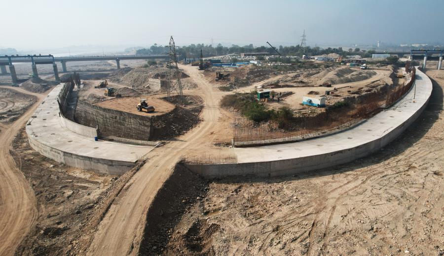
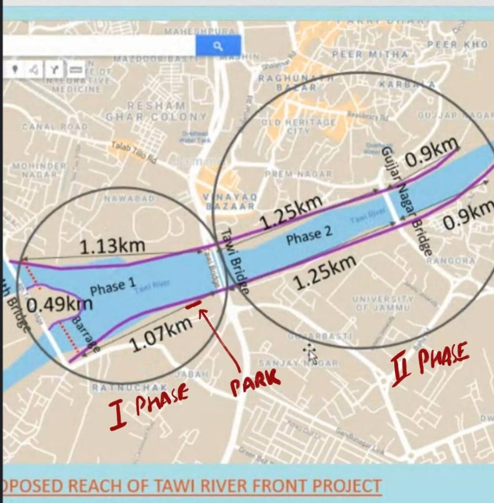
The Tawi RFD project proposes to develop riverfronts along 7 km (3.5 km on either side) long river stretch in two phases starting from fourth Tawi bridge between Bhagwati Nagar and Belicharna where the Tawi barrage is coming up. In first phase the project covers 2.7 km long river stretch lying between Bhagwati Nagar and Bikram Chowk bridges. The second phase will cover the remaining 4.3 km (2.15 km either bank) stretch.
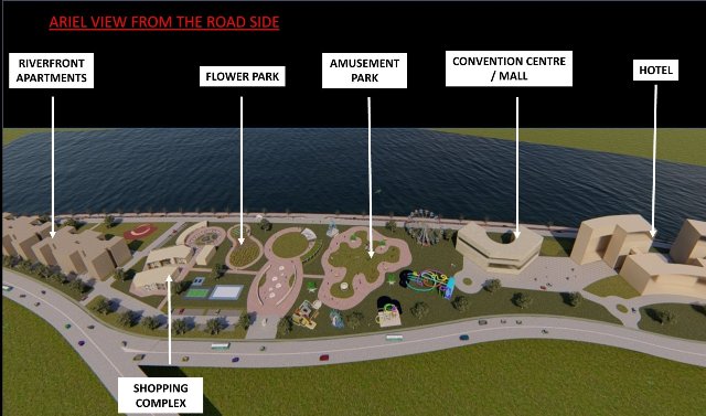
Overall, the RFD involves construction of embankments, interceptor drains, STPs cycling- jogging tracks, walkways, parks, river plazas, promenades, sports & entertainment venues, commercial & residential spaces along the Tawi river in Jammu.
There is different and incomplete information about the Tawi RFD project cost. JMC website shows the project titled as Development of Tawi River Front and Real Estate Development costing Rs. 179.26 crore. The project was started in Feb 2022 and was to be completed in Nov 2023.
According to website the Jammu Smart City Limited (JSCL) has been formed as special purpose vehicle (SPV) to implement over 124 projects in Jammu under Smart City Mission. The list also mentions Tawi River Front and Real Estate Development project under thematic area of Disaster Management.
Further another webpage of Jammu Smart City (JMC) website shares that the length of the project is 7 km including both banks from Bhagwati Nagar bridge to Gujjar Nagar bridge at a cost of Rs. 191 Crore. As per the webpage a barrage is being created by I&FC dept to create pondage for the river front.

There is no clarity on funds already spent and overall cost of Tawi RFD project. Concerned citizens say they have not seen the project DPR in public domain. As per them, the project has not gone through Environmental Impact Assessment (EIA) as prescribed in guidelines for Urban Riverfront Development (URFD) by National Mission for Clean Ganga (NMCG) in Sept 2021 and lacks required Environment Clerance (EC).
As per a JSCL official the total cost of phase one of Tawi RFD is Rs. 194 crore including Rs. 158 crore for infrastructures and Rs. 38 crore for creating public amenities. He also stated that the work has been delayed for some reason and it will be completed by Sept 2024.
However, reports say the first phase would take shape by the end of 2025 and the development of residential and commercial spaces under second phase would go upto 2026.27. As per the reports, the pondage for the project cannot be created until completion of Tawi barrage and diversion of sewage drains.
So far, the both the projects Tawi barrage and RFD are incomplete. The projects have common components supplementing each other but are being built by different agencies separately without any coordination. Both projects have undergone changes in design, DPRs and have been facing delays in execution for long while the construction cost has already crossed Rs. 324 crore including Rs. 131.53 crore in Tawi barrage and Rs. 194 crore in first phase of Tawi RFD. Additionally, both projects have suffered flood damages and are vulnerable to flood threats apart from having potential to turn the flood into disaster.
Concerns over Tawi Barrage & RFD Project
Amid confusion, cost escalation and delays citizens in Jammu are worried over adverse impact of Tawi barrage and RFD project on the river. They fear the scale of work has been damaging the river ecology and could increase flood threats for public infrastructure and local people in near future.
According to Bhushan Parimoo a geologist and environmentalist in Jammu, Tawi is potable water source for the city and lifeline for areas all along its 177km course, however the river has been facing decline in flows due to catchment degradation and shrinkage in glacier areas feeding the river. The river is in dire need of watershed protection and revival instead of turning a flowing river into a lake which is against the very nature of how river functions.
“Tawi is common name for rivers in the region. We have many Tawis here and the Tawi flowing through Jammu is Jammu Tawi. It is considered holy and revered as Surya Putri (daughter of Sun God)”, says Parimoo who heads Environment Awareness Group (EAG) and initiated Save Tawi campaign years back to raise the issues of solid and liquid waste polluting the river.
Parimoo fondly remembers the lost glory of Jammu Tawi describing it a clean flowing river rich in aquatic diversity and supporting fishing and boating activities during monsoon. “The RFD work has even removed boulders from riverbed which worked as natural flood defense mechanism, sewage drains are still polluting the river, green banks are being concretized for commercial, real-estate activities. If there is flood destruction, it’s not fault of the river but of the humans”, laments Parimoo.
Navjeev Digra, a founding member of Climate Front Foundation (CFF) Jammu, further expresses his concerns over potential flood risks from the under construction Tawi barrage and RFD projects stating that the Tawi RFD work has been squeezing the riverbanks from both sides by raising 2 km long concrete-block walls inside the river flood zone.
“We are in climate change era. There are frequent extreme rainfall, cloudburst episodes causing sudden devastating deluge spells in Himalayan region. Under such situation, the Tawi barrage and RFD would prove a huge obstruction during heavy floods and turn into imminent flood danger for river based infrastructures both up and downstream of project area including the barrage, riverbanks and bridges”, says Digra.
He also suspects that construction work on the central portion of RFD covering the river island called Mandal could damage the ancient Ranbir canal structure running underneath across the river. Named after a ruler Maharaja Ranbir Singh the 60 km long canal was built in 1905 to bring Chenab water for irrigation purposes in R S Pura and Samba tehsils in Jammu.
“The ‘U’ shaped concrete protection wall would also be pushing flood currents towards the banks. The greater the flood volume the bigger would be the force of strong eddy currents towards either riverbank exposing the base of barrage and bridge pillars to erosion and collapse”, adds Digra stating that the couple of barrage piers on Nikki Tawi side were damaged by 2014 floods when the gates were even not installed. “Imagine the situation after installation of all 31 gates.”
As per Digra, he has helped Tourism Department develop a biodiversity park on Tawi banks which was inaugurated by the CM Mufti Mohammad Syed in Dec 2015. “But now the officials of JSCL have been pressurizing the Tourism Department to hand over the park land to the JSCL. The RFD work is going on in a chaotic manner and damaging the green spaces, trees flourishing along the river Tawi in Jammu”, claims Digra.

Terming the RFD work as land reclamation and real estate project just to promote tourism at the cost of river eco-system, Digra feels astonished that the project is being built under Smart City Mission. “Climate change is bound to bring heavier floods and if we cannot increase, we should at least maintain the existing flood carrying capacity of the river. The RFD work is doing exactly opposite by reclaiming more than 50 acres of land belonging to the river for commercial and real estate activities”, shares Digra questioning “From which angle the RFD project is smart?”
Similarly, the people of Mandal a huge island formed by the Tawi just downstream the barrage are afraid of the projects for creating September 2014 flood disaster. Pankaj a youth from Mandal who goes by his first name only was about nine-year-old at that time but is still horrified by the intensity of deluge.
“Our homes went under four to five feet of flood waters in 2014 destroying all essential commodities and home appliances. The island remained disconnected from electricity, water supply for about three months. All the roads on the island were damaged. The bridge links to Jammu were washed away. Food and water packets were air dropped by army. Power and water supplies took half a year to be restored and our lives remained miserable for about a year” says Pankaj while recalling the 2014 flood disaster.
He says that the administration has done no consultation process with the people of about 40 villages inhabiting the river island regarding the flood impacts of the barrage and RFD projects. “Our group Friends of River Tawi (FORT) reached out to the concerned govt departments but they simply have refused to share any information about the project”, says Pankaj.
In addition to these serious issues; citizens in Jammu are equally concerned about rising pollution load in Tawi river. Presently the total sewage generation in the city is estimated to be around 170 million liters per day (MLD). In its Aug 2022 compliance report to National Green Tribunal (NGT), the Jammu & Kashmir Pollution Control Board (JKPCB) has mentioned about a network of 26 drains including 20 from north and 6 from south polluting Tawi river in the city.
There are 4 STPs in the city with total installed capacity of 71 MLD while the actual utilization is just 27 MLD as the sewerage network scheme ongoing since 1996 is still incomplete. Similarly, a huge part of 501 tons per day (TPD) waste generated in the city including plastic, bio-medical and construction debris is dumped in and along Tawi river. Recently, work on sewage interception and diversion plan costing around Rs. 45 crore to divert drains from Tawi RFD stretch has been taken up.

“Tawi supplies about 60 percent of potable water to Jammu city. Despite this, constant increase in solid and liquid waste contaminating the scared river” says Anomal Ohari a member of FORT the group behind regular river cleaning drive in the city. According to Ohri the exiting STPs in the city are running defunct at most of the times. “The city is lacking efficient sewerage infrastructure but like in Sabarmati model, the RFD proposes to divert all the sewage pollution downstream project area. Is it right way to deal with the river pollution”, asks Ohri.
Ohri finds Tawi RFD project contrary to NMCG guidelines calling it environmentally insensitive, climate mal-adaptive and socially exclusive. Though disappointed, Ohri urge administration to focus on actual problems deteriorating the river health instead of pushing the cosmetic beautification project. “What Tawi needs is holistic revival plan and the Sabarmati RFD is a delusion. Government has no mandate to commercialize and corporatize our rivers”, says Ohri terming the Tawi RFD a self-induced climate disaster in the making which Jammu citizens want government to comprehend before it becomes a reality.
Bhim Singh Rawat (bhim.sandrp@gmail.com)
End Notes:
1 File containing links of government websites, studies and news reports on Tawi Artificial Lake & River Front Development Project in Jammu.
