GUEST ARTICLE BY SARANG YADWADKAR
Pune,
A city along the banks of five rivers,
A city with 7 dams on the upstream,
A city surrounded by pristine green hills,
Hence probably the only city to enjoy abundance of water even in drought like situation.
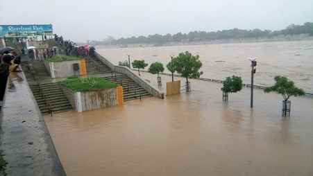
Due to this abundant availability of water, the city of Pune grew very rapidly. But this situation has a darker side of frequent flooding as well, which the citizens have witnessed and experienced quite a few times. The most recent example, is the floods in 2019. In a few hours hundreds of houses were washed away; properties worth Crores of rupees were destroyed and 25 innocent people lost their lives. The flood water breached the flood levels to inundate innumerable houses and even a hospital. In 2020 too, Bhairoba Nala breached its limits.
Why is this happening so frequently these days?
Was it similar in the past?
Will it be the same in future?
Who is responsible for this?
There are innumerable questions. But the real question is, “When will be find logical answers to these questions?”
For this we need to ponder over a few crucial aspects.
As mentioned, 5 rivers namely Mula, Mutha, Ramnadi, Devnadi and Pavana are flowing through Pune city. These 5 rivers form confluences and flow away from Pune as one river, Mula-Mutha. In short, water flows into Pune from 5 different catchments and there is only one outlet to that, Mula-Mutha River. Over and above this, Pune’s topography is saucer shaped leading to frequent inundation of the central city as storm water runoffs gush down from all directions whenever it rains heavily.
Total 7 dams (Khadakwasla, Panshet, Varasgav, Temghar, Pavana, Mulshi and Kasar Sai) are constructed on these rivers on the upstream on the West of Pune. These dams are not only close to Pune, but they are close to each other as well. If there is a cloudburst in the West of Pune, the catchments of all these seven dams will receive huge runoffs simultaneously and enormous quantities of water will have to be released from all these dams which will hit Pune city within no time.
Another unique characteristic of the rivers and streams in Pune is the topography of their catchments. All these catchments are hills and valleys forming steep slopes. Therefore, whenever it rains heavily, the surface runoffs gush down to the rivers and streams so fast that the flood levels rise hardly in few minutes leading to flash floods, without giving any opportunity even for evacuation. The floods of the Ramnadi and Ambil Odha have already proved it.
Another important aspect that needs some serious attention is the report prepared by “The Energy and Resources Institute” (TERI) in 2014 for Maharashtra Govt: “Maharashtra State Adaptation Action Plan”. In this report, the impacts of Global Warming on Maharashtra are discussed in-depth and scientific ways and solutions to avoid the same are advised. The report predicts that there will be a rise of 37.50% in Pune’s annual rainfall with less rainy days and increased frequency of cloudbursts. This clearly means Pune city is headed towards more severe and frequent floods in the future.
In last 20-25 years health of Pune rivers has deteriorated from bad to worse. Pune’s population has increased by leaps and bounds leading to generation of huge quantities of sewage which is not being treated completely as the capacities of PMC’s Sewage Treatment Plants are extremely poor and their efficiency is questionable. As this partially treated sewage is released in the rivers from all STPs, through most of the year, all these rivers are practically carrying only sewage rather than fresh water. And on the top of this, there are huge quantities of industrial effluents released in the rivers. The quantity of industrial effluents is so much, that the monitoring by the Pollution Control Boards has become questionable.
Solid waste management is another serious concern in Pune as is in all cities. Keep aside the waste segregation and processing, we are still stuck with the problem of 100% collection of garbage. The garbage strewn everywhere around is proof of carelessness of the citizens. This garbage, mainly plastic finally flows with the surface runoffs and gets stuck in the storm water drainage system leading to water stagnation at many locations, which we call as “pluvial floods”.
Water carrying capacity of all rivers and streams in and around Pune is drastically eroded in last many years. For this, initially we need to understand the concept of “Flood Lines” which are identified by Water Resources Department. There are two types of flood lines, Red and Blue. The Blue Flood Lines mark the level of the flood that comes every 25 years whereas the Red Flood Lines mark level of the flood which comes every 100 years. The portion of land between the two Blue Flood Lines is known as “Prohibitive zone” where no construction is permissible. And the portion of land between Blue Flood Line and Red Flood Lines is known as “Restrictive Zone” where construction is permissible but under certain conditions. Under any circumstances, the cross section of the river cannot be altered due to which the water carrying capacity of the river reduces.
In and around Pune, there are innumerable encroachments upon floodplains, riverbeds and streams. Most of these encroachments are unauthorized but some are “authorised”, e.g., car parking on the riverbed, Chowpatty, sewage pipes, Metro pillars on the riverbed etc. Due to these encroachments, the cross section of the riverbed is reduced at many locations and so is the water carrying capacity. We do have experienced this in the recent years. In 2011 when the flow of 67,212 CuSecs. (Cubic Feet Per Second) from Khadakwasla dam was released it reached the same level as it had in 1997 when 90,000 CuSecs. were released. The Blue Flood Line, which has been identified for a flow of 60,000 CuSecs., was breached by the flow of 45,474 CuSecs. in 2019.
The conclusion emanating from this situation is that; on one hand the severity of rainfall and frequency of cloudbursts is on the rise, while on the other hand, riverbeds are being strangulated on large scale by encroachments. Just to give an analogy, we can compare this situation with the artery supplying blood to our heart. Gradual deposition of cholesterol reduces blood supply to heart, ultimately leading to cardiac arrest. Similarly, the encroachments on the riverbeds are eroding their water carrying capacities as if we are waiting for a cardiac arrest. Unfortunately for today’s awful situation local politicians and administration is responsible and the innocent common citizens would be left with no choice but to face its gruesome consequences.
The water release capacity of Khadakwasla dam is 100,000 CuSecs. This release can reach Pune within minutes and if it is raining in the free catchment on the downstream of the dam, there is additional storm water flow of at least another 50,000 CuSecs. This means that if it rains cats and dogs in the catchment of the dam and in the downstream, the city of Pune will be left with no choice but to face the deluge of 150,000 CuSecs. only from Mutha River. If the Blue Line identified for the flow of 60,000 CuSecs. is breached by 45,474 CuSecs., can we imagine what catastrophe 150,000 CuSecs. would cause in Pune? And this could happen in any rainy season, including in 2021. Unfortunately, it appears that the politicians and administrators are least concerned about it.
The Central Water and Power Research Station (CWPRS), a reputed and Pune-based organization, recently released a report on the impact of riverbed construction of metro on the flood levels of Mutha River. The report shockingly reveals that in the present circumstances even without metro pillars, the flow of 60,000 CuSecs. which is expected to touch Blue Flood Line will actually flow 5 Ft. above it. In short, due to encroachments, the flood level in Pune has gone up by 5 Ft. which is not only serious but a very scary fact. If the flood level rises by 5 Ft., the flood water will spread few hundred Ft. beyond riverbed inundating thousands of homes. The question is, even after the report was released in January 2021, why are our politicians and administration have chosen to remain tight-lipped about it?
The confluence of Mula and Mutha is another dimension to this scary situation. Similar to 150,000 CuSecs. from Mutha, Mula River can bring in flow of 160,000 CuSecs. These rivers meet each other near Sangamwadi at a right-angle causing reduction in the velocity of water of both rivers. This further aggravates the flood situation on the upstream side of both the rivers.
In Pune, biodiversity in the rivers is another vital subject related to the rivers. The pollution and encroachments on the rivers have caused immeasurable damages to the biodiversity. Innumerable trees have been axed down. The riparian wetlands which is a prosperous and intricate ecosystem on its own is completely disturbed by these anthropogenic interferences. These wetlands consist of a variety of plants, innumerable species of insects and reptiles and hence interminable presence of local as well as migratory birds. It is not yet too late, we still can save these precious wetlands by protecting them and by of removing the encroachments on the riverbeds, in fact it is our responsibility.
Except for few days of monsoon, it is only polluted sewage that flows in the rivers throughout the year. Due to lack of dissolved Oxygen, hardly two species of fishes are surviving in the river water. The fishermen are dependent on these fish for their livelihood. If we stop releasing polluted water in rivers, the aquatic life will bounce back to its original. Mula-Mutha is so polluted due to the sewage and the industrial effluents that even the groundwater has become highly toxic not only in Pune but up to a few hundred Kilometres downstream. This polluted water of Mula-Mutha has also adversely affected the agriculture depending on the river. It is also observed that certain health disorders are on the rise in the people and the cattle along both the banks of Mula-Mutha.
On this background, Pune Municipal Corporation has proposed a massive project of River Front Development on the 44 Km. long rivers in Pune. The cost of this project as estimated in 2018 is Rs. 2619 Cr. Obviously this cost is to be borne by the tax paying citizens of Pune. Hence, we need to know, what this project is all about, how it is, what are its consequences etc. It’s not only the need of the hour but also our responsibility to search for the scientific and logical answers to all these questions.
What is the “Pune River Front Development Project”?
Part-2: PUNE RIVER FRONT DEVELOPMENT PROJECT:
It is stated in the Detailed Project Report (DPR) of River Front Development project that following were the objectives while envisaging and planning the project:
1) Reduce the floods caused by the rivers.
2) To have clean rivers
3) To rejuvenate the rivers,
4) To develop a link between rivers and citizens.
But the question is, will these objectives be truly delivered by this project?
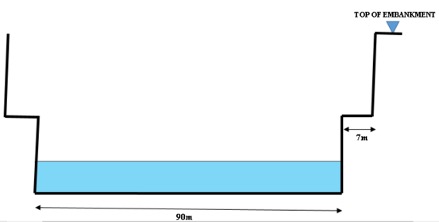
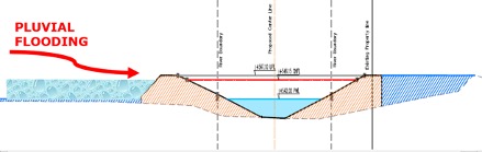
Pune Municipal Corporation boasts that, 44 Km. long Mula, Mutha, and Mula-Mutha rivers flowing within PMC limits will be “rejuvenated” due to this project. The river Front Development (RFD) project predominantly comprises of channelising and converting the rivers into canals by constructing 30- 40 Ft. high concrete or stone walls (Embankments) along both the banks.

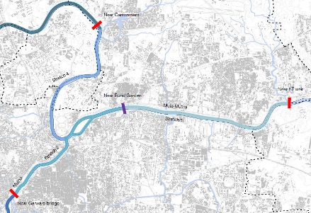
Apart from the embankments, three barrages are to be constructed at following locations:
1. Mutha River – Near Garware College
2. Mula River – Kaspate Vasti, Near Cantonment
3. Mula Mutha River – Near Mundhwa K. T. Weir.
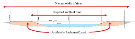
The embankments are to be constructed inside the flood lines, narrowing the river and reducing the riverbed’s cross-sectional area. The floodplains on the outer sides of these embankments are to be filled with soil to create artificial gardens. The Water Resources Department (WRD) has specifically warned Pune Municipal Corporation not once but twice on 30.1.18 and 15.11.19 that, “While implementing the River Front Development project on Mula, Mutha, and Mula Mutha rivers, care should be taken that the cross-section of the river must not be reduced.” It appears that PMC and their project consultant has decided to completely disregard these instructions from the WRD while implementing the project.
As mentioned earlier in Part 1, Pune is a flood-prone city. There are two root causes for this, first is increasing rainfall and the second is gradually constricting riverbeds due to encroachment (same is the situation of all streams). Rains, being a natural phenomenon; is not under our control but what can be controlled by us is to free all streams and rivers from encroachments.
As a matter of fact, the River Front Development project would further narrow down the rivers by constructing embankments to create more land by reclaiming the riverbed or the flood plains. Reduction in width of the river would reduce its cross-sectional area necessary for uninterrupted flow of water. Consequently, whenever water is released from the dam, that flow will get less space to flow in the riverbed leading to steep rise in flood levels inundating large areas of the city.
The embankments proposed to contain the rivers in this project are pretty high. At some locations they are above the surrounding ground level. This will obstruct the storm water from other parts of the city to flow naturally in to the river causing further inundation in the residential localities.
The RFD project report highlights that Central Water and Power Research Station (CWPRS) has given approval to this project after in-depth hydrological study of the rivers. A letter stating the same is also attached in the report but when we approached CWPRS, they categorically stated, “CWPRS was requested by PMC to examine hydrology and hydraulics report prepared by the HCPDPM (project consultants).”, CWPRS also clarified that, “CWPRS did not conduct any study for RFD of PMC”. This raises a plethora of questions:
- Given the history of floods in Pune, why isn’t CWPRS involved to conduct an independent detailed study? Or was it avoided intentionally?
- If CWPRS did not conduct an independent study then what is the credibility of their so called “approval”?
- Why are the citizens of Pune misguided about this?
And most importantly
- Who will be responsible when flood levels rise? The Project Consultant or the Politicians or the administration or Water Resources Department, or CWPRS?
In short, the River Front Development project is going to be a perpetual arrangement leading to more frequent and intense flooding of Pune city.
Furthermore, just to show water (stagnant) in the rivers, three new barrages are to be constructed. The impounding water in these three barrages will create new problems. The water currently flowing through rivers is nothing but stinking half-treated sewage. If this water stagnates, the stink would further aggravate, and the levels of the stagnant water will also rise. This stinking stagnant sewage will flow back in to the streams. This will instigate mosquito infestation everywhere in the city. The stagnant water will further lower the already low dissolved Oxygen (DO) levels leading to extinction of the remaining two fish species (Mangur and Tilapia) in the river.

Environment Clearance for this River Front Development project has been accorded by State Environment Impact Assessment Authority (SEIAA), but in a highly objectionable and controversial manner from multiple aspects.
- The SEIAA, in its meeting held on 11.10.19 issued Environmental Clearance for this project. The minutes of this meeting specifically mention, “Project Proponent informed that there are 4 (four) barrages to be constructed. As the Committee has no expert working in this field, the Committee has not gone into this aspect. Proper appraisal from proper authority in this regard is solicited.”
- It also is clearly visible that the Environmental Clearance is accorded by SEIAA; ignoring the very basic facts and features of the project. While according the EC, SEIAA has mentioned in the minutes at point No. 18 (a) that the proposed Built-up area of this project (FSI and Non-FSI) is 00 Sq. M. i.e., the project does not propose any Built-up area at all. Completely in contravention with this, the Cost Estimates clearly mention about many built components like Retaining Walls, Promenades, Embankments, Stairs, Ghats, Toilet Blocks, Food Courts, Parking Spaces, Plazas, Bridges etc. etc. All this covering minimum Built-up area of 17,41,684 Sq. M. (1,87,47,486 Sq. Ft. or 430 Acres). How could SEIAA overlook such a massive part of the project while issuing the EC?
- Further, while providing the “Details of the demolition with disposal” at point No. 30, the SEIAA minutes specifically say that, “There will be no demolition.” Whereas the Project Cost Estimates show that some Bridges, Weirs, Causeways, Check Dam, Roads, Retaining Walls, Compound Walls, Small Buildings and Ghats will come under the hammer of demolition at the lump sum estimated cost of Rs. 5 Cr.
Such an Environmental Clearance given by SEIAA raises innumerable questions:
- If the State Environment Impact Assessment Authority could not study the impacts of the barrages in absence of Experts, then on what basis was this project accorded the Environmental Clearance?
- As per the SEIAA directions, was any study conducted independently by any competent authority?
- If such independent study was conducted, what are its conclusions?
- What is the validity of the Environment Clearance which is given completely overlooking the massive Built-up area of 1,49,00,000 Sq. Ft. or 342 Acres?
- Why the demolition of so many structures like Bridges and Weirs, Causeways, Check Dam, Roads and some Retaining Walls, Compound Walls, Small Buildings and Ghats etc. was not considered by SEIAA?
- All this, because of premeditated misrepresentation by the Project Consultant and Proponents or sheer ignorance of the SEIAA members?
And the citizens of Pune need logical answers to all these questions.
Apart from this, the embankments to be constructed on the riverbed will have some other serious adverse impacts, the foundations of these 30-40 Ft. tall walls will be deep down in the riverbed. Due to this, the main course of river will get completely disconnected from aquifers on both the banks. River banks are recharge and discharge zones of groundwater. Some aquifers feed the rivers by releasing groundwater into it and rivers also recharge ground water through the aquifers. This natural process goes on incessantly maintaining the ground water table. The concrete embankment walls and their deep foundations will stop this permanently affecting the groundwater table adversely.
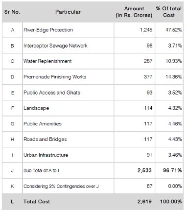
The cost estimate clearly shows that 80% of the cost is for different types of civil constructions. There is no mention of purifying or cleaning the rivers. How the rivers could be rejuvenated by such concretisation and without cleaning? This is a million-dollar question.
There are few more shocking revelations in the Detailed Project Report of the project.
Chapter 6.3 discusses raising finances for this project. On page 224, it states, after erection of embankments, 625 Ha (1544 Acres) of land will be created or reclaimed on the flood plains, through which finances can be made available for this project. Does it mean that the reclaimed flood plains which form the integral part of the riverbed will be monetised for this beautification project?
Furthermore, it is mentioned on page No. 228, “As per the study, approximately 73 Ha of land is under the ownership of various government authorities. A possibility to lease out or sale or give development rights of the government owned land needs to be explored as a source of revenue generation.” This means that the 73 Ha. (180 Acres) of centrally located government land, which is a public property will be sold to provide finances for this project. Is this acceptable to the citizens?
This clearly means that the future of the centrally located priceless 1544 Acres of reclaimed land and 180 Acres of government land will be completely in the hands of the Politicians, administration and the SPV (Special Purpose Vehicle) formed for this project. Citizens who are the real owners of this land will stand at the losers’ end. The question is, were the common people taken in confidence while deciding such policies? And is this acceptable for Punekars? Close look at the Detailed Project Report of this River Front Development project raises a strong suspicion that this project is not really intended to rejuvenate the rivers at all but this actually is a real estate development project. The land belongs to citizens, money will be spent from the taxes collected from the citizens, the risk of floods will be for the citizens at the cost of irreversible environmental damage but for the benefits of only few selected people.
Gist of River Front Development project.
- The River Front Development project is not going to clean and purify the rivers.
- Biodiversity on the riverbank will be irreversibly destroyed.
- Ground water table will deplete.
- Some existing bridges will become redundant and the existing riverbed road will be closed.
- The rivers will become canals due to channelisation, altering their natural flow.
- Flood levels will rise and more areas will submerge underwater
and
- All this at the cost of several thousand Crores from our pockets.
It’s not just about Finances,
It’s about the irreversible Environmental damages also,
It’s about the safety and security of our next generations also,
It’s about Punekars, their families and houses not only on the riverbanks, but away from the banks also.
The question is, do we want to repeat the history of 1961 Panshet floods?
We do want our Rivers to be beautiful,
But before that they should flow clean,
And even prior to that, we want our Rivers to be safe.
The need of the hour for us is to rise,
Not for our sake, but for the sake of our future generations.
–Sarang Yadwadkar
(yadwadkarsarang@gmail.com)
- Architect,
- Member of the Planning Committee of the Development Plan of Pune City.
- Has filed many cases in the National Green Tribunal against river pollution and encroachments on riverbeds.
(The original article was written in Marathi, the translation is by Ms. Tanmayi Shinde.)

Excellent analysis. I hope and pray that the powers that be apply their minds to it and just follow their greed.
I have sufered for the past three years with storm water flooding my home to about 3 ft ht.
The analysis is absolutely accurate.
Builders have blatantly changed the topography of the land around and also paved most open surfaces.
Natural flows have changed leading to flooding.
LikeLike
Many thanks for sharing your feedback and also your experience. Keep sharing.
LikeLike