Guest Blog by: Amruta Pradhan
Background Three rivers (among some others) with a total length of 44km traverse through Pune city. Mula river flows a distance of 22.2 km, Mutha River 10.4 km and Mula-Mutha River 11.8 km. Plight of these rivers is well known. They have been featured in the list of 300 most polluted rivers of India. Pune Municipal Corporation (PMC), Maharashtra Pollution Control Board (MPCB), Maharashtra Water Resources Department (WRD) etc. have pulled number of controversies over river pollution, illegal construction of roads and townships through river bed and most recently Pune Metro being proposed through the river bed. Making a case for ‘rejuvenation’ of the ‘neglected rivers’, PMC has now proposed Pune Riverfront Development Project (PRDP).[1] The project has been designed by the same HCP Design Planning & Management Pvt. Ltd (HCP) led by Ar. Bimal Patel from Ahmedabad who conceived and implemented Sabarmati Riverfront Development Project (SRFDP).
In September 2014 SANDRP in its article “Riverfront Development in India: Cosmetic make up on deep wounds” had raised serious issues regarding several riverfront development projects sprouting across India. Following the footsteps of SRFDP these projects treat rivers as extension of urban spaces and are more about encroachment of floodplains and river beds for real estate than restoration. Pune’s Mula-Mutha Riverfront Project being one among them, maintains the same focus. The project also shows several signs of an ill planned project which may exacerbate the risk of flooding and may take a severe toll on water quality and river health. This article questions some underlying assumptions upon which the project has been designed. Draft Master Plan (DMP) of the project prepared by HCP has been referred as a base document. The Environmental Impact Assessment (EIA) report of the project is of a poor quality and devoid of even basic information about the project. Thus was not referred for details.
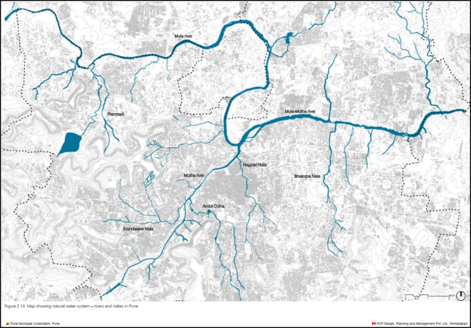
Pune’s River System Mula and Mutha rivers which traverse through the City are tributaries of Bhima river which in turn is a tributary of River Krishna. They merge near the centre of the city to form Mula-Mutha River which exits the city flowing Eastwards and falls in Bhima River.
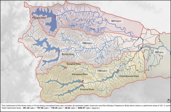
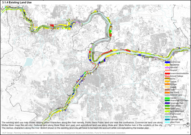
Mula River originates near Mulshi dam and traverses a distance of 64 Km before meeting Mutha River at Sangam wadi. 22.2 km stretch of Mula river downstream of Mulshi Dam falls within the PMC and PCMC area. Mutha river originates about 45 km to the west of Pune at village named Vegare, near Khadakwasla Dam. It flows a distance of 15 km before meeting Mula River. Out of this around 10.4 km stretch of the river downstream of Khadalwasla Dam is within PMC area. Mutha river has two tributaries, Ambi and Mose. Mutha flows though the core of the Pune city. After the confluence Mula Mutha flows Eastwards for another 50 km before falling in Bhima river. Of this 50 km, 11.8 km lies within PMC limits. Other than this, several rivulets feed the mainstream of the Mula-Mutha Rivers. Dev Nadi and Ram Nadi feed Mula River; Erandwane Nala and Ambil Odha feed Mutha River while Bhairoba Nala feeds Mula-Mutha River. The total catchment of all these rivers adds upto 2095.97 sq km.
The natural flow of Mula-Mutha rivers has been retained by five upstream dams. Details of these dams are given in Table-1.[2] PMC sources raw water from Khadakwasla dam which is fed by gravity from three upstream dams viz. Panshet, Varasgaon and Temghar. Khadakwasla is the last dam in this cascade[3]. While PMC has been drawing 14.5 to 16 TMC of water annually to supply 194 lpcd water to its citizens; flow of Mula-Mutha has been reduced to trickle. What flows through the river through most part of the year is untreated sewage poured into the river by the nallas and treated sewage let out from the sewage treatment plants (STPs), albeit not confirming to the discharge standards set by the MPCB.
| Table 1: Dams on Mula-Mutha Rivers (Source: SANDRP 2016) | ||
| River | Dam | Storage capacity |
| Ambi River | Panshet Dam | 10.64 TMC |
| Mose | Varasgaon Dam | 12.81 TMC |
| Mutha | Temghar Dam | 3.71 TMC |
| Mutha | Khadakwasla Dam | 1.96 TMC |
| Mula | Mulshi Dam | 19.87 TMC |
Plight of Mula-Mutha
Rivers of Pune have consistently made headlines for pollution for the past four years and more. In a 2015 report of CPCB titled “River Stretches for Restoration of Water Quality”[4] all the three Pune rivers were listed for their highly polluted (priority II) stretches. Out of 22 km length of Mula river which flows though the city, 6 km from Bopodi to Aundh Gaon; the entire 12 km stretch of Mutha river from downstream of Khadakwasla dam to Shivaji Nagar (just upstream of the Mula-Mutha confluence) and the 15 km of Mula-Mutha river flowing through the city have been flagged by CPCB for all the monitoring locations having BOD (biochemical oxygen demand) between 20-30 mg/l. According to the ‘Water Quality Standards for Best Designated Usages’ prescribed by MPCB[5] water with BOD exceeding 10 mg/l is termed as ‘Not fit for human consumption, Fish & Wildlife Propagation’.
In 2018 report of CPCB, the stretches of Mula and Mutha have shifted under Priority I category. Mula-Mutha stretch continues to be under Priority II.[6] Criteria for Priority I includes all monitoring locations exceeding BOD concentration of 6 mg/l. Another criterion for Priority I stretches is that at certain locations the BOD exceeds level of 30 mg/l which is a discharge standard for sewage treatment plants and effluent treatment plants to fresh water sources. What this means is the river water at these locations is more of effluent than fresh water.
It is this effluent like water which is unfit to support any aquatic life flows through the river in non-monsoon seasons.
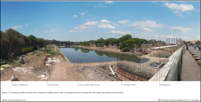
Mula-Mutha rivers also face severe encroachment. According to the DMP of PRDP; 437 ha of area falling within red line (46%) has been encroached. PMC also has routinely violated the red and blue flood lines.[7] In year 2000 PMC constructed a road through the Mutha Riverbed from Mhatre Bridge to Sambhaji Bridge and then to Shivaji Bridge over a distance of 4.3 km. In 2013 a 2.3 km long (and 24 m wide) road from Vitthalwadi to NH-4 bypass was being constructed illegally through the Mutha Riverbed. This was subsequently challenged in NGT. In its final judgment in July 2013 NGT ordered the road to be realigned. Subsequently a contempt petition was filed when PMC failed to comply with the orders where the NGT in January 2015 again ordered removal of the constructed road. Currently 1.7 km stretch of Vanaz-Ramwadi Metro corridor is proposed through left bank of river Mutha. Along with this a 30 m wide road with a length of 7.4 km has also been proposed within Mutha riverbed as a part of 2007-27 DP of Pune city.
The Pune Riverfront Development Project
With such dire state of Pune’s rivers, PRDP has been introduced making some attractive promises. It promises to make the river as a clean, aesthetic, people friendly, green space. In a city like Pune experiencing more and more space crunch and shrinking green areas owning to its haphazard growth; such a promise is indeed a valuable one. Another promise that it makes is to restore the river water quality, “enhance its ecology” by retaining and replenishing water. This is another valuable promise considering the dire state of the river stinking with sewage water and filth. While these promises sound very optimistic, the project design seems to ignore some vital bio-physical and social interactions between the river, the landscape through which it flows and the people that occupy that landscape. The project has been designed making numerous bio-physical and social assumptions. Careful look at them shows that there is a hugh probability that the interactions between the river and the landscape may not go as imagined and the river may not behave as assumed. As a result, it may increase Pune city’s vulnerability multifold in terms of flood and water quality; especially with predicted changes in rainfall due to climate change.
But first let us take a look at the project design.
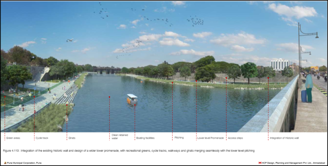
Even though the project is called Mula-Mutha River “Rejuvenation” Project in its EIA report, it is more about encroachment on flood plain and riverbed for real estate than the river rejuvenation. Huge concrete embankments— just like Sabarmati Riverfront Project—are the hallmark of the PRDP as well. The project proposes to build total 92.5 km of embankments reclaiming whopping 180 ha of land. The project also proposes to build four barrages on three rivers to store 57122.5 mm3 of water for the riverfront. The water is to be made available from the treated sewage from the existing and the proposed STPs under a separate project titled “Pollution Abatement of River Mula-Mutha in Pune” funded through soft loan of ₹ 1000 Cr by Japan International Cooperation Agency (JICA). Some added elements like Phytorid beds to restore the water quality, fountains for aeration of the riverfront water have been included in the project. The claim is that this treated water when stored in barrages will replenish the river. PRDP also proposes number of public places along the embankments such as new ghats, visarjan tanks, eateries, boating joints etc.
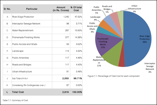
The Project cost is massive ₹ 2,619 Crores. Out of this 11% cost is for the barrages, 4% cost is for catering to the water quality (bridging of this project and the JICA project). Even if we buy into the argument that this cost is for river water “replenishing”; it forms only 15% of the project cost. Other 85% cost is for building the embankments and converting that into a “vibrant” “continuous public realm”. 48% cost is for constructing the embankments alone!
The project is proposed to be implemented in three phases, starting each from 2019, 2023 and 2026. The 10% of the capital cost is to be incurred in each year and 1% per year is considered to be the maintenance expenditure with an annual escalation of 4%.
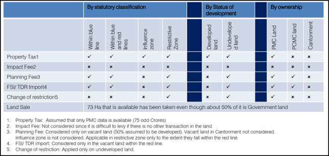
The biggest fact that confirms that the project is more about real estate than river is that the project finance is proposed to be raised by mechanism where an increase in land and property value is seen as an impact of the project. The project will be financed by way of charging impact fee, betterment charges, development charges etc for the land and properties directly benefitting from the project. This is essentially the land within the flood lines.
Details of the project elements
- First objective of the project is to reduce the risk of flooding.
(1a) The project identifies structures such as bridges, causeways, weirs, check dams etc. built within the river to be the obstructions to the flow of water. Thus as a first step it is proposed to “reduce the flood impact” of these structures by “removing, streamlining, remodeling, or rebuilding them.”
(1b) Silt deposition due to the existing “solid check dams and weirs” has been identified as another problem for the afflux of the flood water. The project proposes gated barrages for water retention “so that flood can easily pass without creating afflux or rise of water level in upstream.
(1c) Rocky out crop from River bed of Mula and Mula-Mutha and the cross current due to eddies produced from the surface of the banks are said to “interrupt the conveyance carrying capacity of the side channels.” The project thus proposes removing these rocky out crops from River bed and smoothening the uneven edges of the river along entire 44km length of the project area.
(1d) The project proposes to protect low-lying areas along the River from flooding by constructing 92.5 km embankments along the entire project area of 44kms of river stretch. Based on the level of development (encroachment) and public land available for embankment development; three kinds of embankments have been proposed namely ‘Engineered Section’ of 19.8 km length for the intensely developed core city areas, ‘Urban Riparian Section’ of 38.8 km for moderately developed city areas and ‘Rural Riparian Section’ of 33.9 km for the sparsely developed outskirts of the city.
It is assumed that after removal of the identified obstructions to the flow of water and implementation of various solutions so as to improve the flood carrying capacity of river; the blue line and the red line marking the probability of flood levels once in 25 year and once in 100 years respectively will be duly lowered.
- Second objective of the study is to clean the river and make it pollution free
(2a) according to the DMP of the project, there are 88 piped and 50 open outfalls discharging sewage and wastewater directly into rivers. The project proposes to construct approximately 18.15 km of Trunk lines along the river to curb these piped outfalls by diverting them to existing or proposed STPs. Additionally, 2km trunk line has also been proposed along Ram Nadi and to 5km along Mula River within PCMC area curb the pollution.
(2b) Realignment of the existing trunklines within the river bed.
(2b) All the important Nallas like Ambill Odha, Bhairoba Nalla, Nagzari Nalla, Erandwana Nalla, etc. which contribute to the river flow bring untreated sewage into the rivers along with the surface runoff during monsoon. In order to reduce river pollution due to these Nallas, gabion walls are proposed along the Nalla with a Phytorid beds at the point of termination at 10 locations. It is assumed that after passing through the root zones of the Phytorid beds will consequently achieve the required quality standards fit to be released into the river.
(2c) The DMP states that there are 9 functional STP’s with a capacity of 567 MLD and 252 MLD of untreated sewage being discharged directly into the river (further sections of this article will show why this is a gross underestimation). PMC has proposed 10 STPs under JICA proposal. The project proposes to augment the existing sewage treatment capacity by constructing 11 new STPs of 396 MLD treatment capacity to cater to the sewage generation upto the year 2027.
- Third objective is to retain and replenish water for the riverfront
(3a) The DMP of the project states that the existing structures built on the rivers within PMC area consist of 1 barrage, 2 check dams, 3. The DMP states that these structures “do not hold enough water”, majority of the river bed is thus dry or mostly holds polluted water.
The DMP also identifies the “solid design” of these structures as an obstruction to the river flow resulting in siltation in upstream areas. Thus the project proposes to replace the existing water reservoirs with advanced gated barrages with low crest level that do not act as an obstruction.
(3b) The project proposes following structures to retain water.
| Table 2: Barrages Proposed under PRDP (Source: Source: DMP Pune River Rejuvenation Project p.109, 113) | |||||
| Stretch No. | Barrage location | New/Old | River | River stretch | Water to be retained (MLD) |
| 1. | Near Garware Bridge | New | Mutha | From Khadakwasla dam to Garware Bridge | 4948.74 |
| 2. | Near Bund Garden | Old | Mutha | From Garware Bridge to Bund Garden | 8636.13 |
| 3. | Near Cantonment | New | Mula | From Wakad-Balewadi Bypass to Cantonment | 16707.16 |
| 4. | – | Mula | From Cantonment to Confluence of Mula Mutha | 11995.14 | |
| 5 | Near KT Weir | New | Mula-Mutha | From Bund Garden to KT Weir | 14835.29 |
| (DMP does not give any details about the design features of the barrages like height, length, gate type etc.) | |||||
(3c) Aeration fountains at 15 locations are proposed to maintain the desired DO level in the stagnant water.
- Fourth objective of the project is to create a continuous public realm along the river.
(4a) The 44 km of embankments are imagined to create a continuous public realm by way of promenades which are a part of their design. Access – perpendicular and parallel to the promenade have been proposed at intervals of every 300 – 500 m.
(4b) Additionally, 270 more access points in terms of stairs and ramps are to be provided to access the riverfront.
(4c) The project also proposes numerous public spaces—In addition to the existing 20 ghats along the river, the project proposes additional 50 ghats. They are believed to make the riverfront a more vibrant, dynamic, highly spirited and distinct public space. The project also proposes 25 new visarjan tanks, 16 boating facilities and around 18 eateries along the riverfront.
- The last objective of the project is to improve access and connectivity along the river.
The project thus proposes to integrate several roads proposed by PMC within the flood lines as a part of Development Plan 2007-27.
The project shows lack of understanding of the bio-physical reality of the river
The project is clearly concerned about only select elements of the Pune’s rivers viz. flow, floods, land in the floodplains and the river water quality. These elements however do not exist in isolation. They are a result underlying bio-physical processes which are the essence of the river ecosystem.
Bio-physically speaking, river is a ceaseless flow of water (resulting from gravity) along with processes of erosion and sedimentation. River ecosystems encompass river channels, its floodplains and riparian areas forming a diverse mosaic of habitats at the transition zone between the land and water. Rightly termed as a ‘living ecosystem’, river is much more than just being a conduit of water. It is a sum of complex interactions between abiotic physical-chemical components of the river such as water flow, sediments, substrate, light, temperature, dissolved oxygen, pH etc. and the biotic components such as plants, animals, microorganisms adapted to the variations of the flow. They all play a crucial role in maintaining the flow of important provisioning services for humans such as freshwater supply, groundwater recharge; regulating services such as buffering flood flows and maintaining the water quality and supporting services such as breaking down waste, nutrient recycling and maintaining the primary productivity. Thus as important as river’s channel are the riparian belts, hyporheic zone, flood plains and the aquatic biodiversity.
The most striking aspect of the project designed around real estate in the name of flood and water quality is the denial for these vital underlying processes.
The aim of the project, the DPR states, is:
“The riverfront is proposed to be developed as a green and recreational space that can transform the existing neglected waterfront into a centre for social, cultural and recreational activities in the city. It will create a vibrant and a completely public riverfront which will provide many opportunities for leisure and recreation.”
While proposing to make river banks as a place for leisure and recreation, the project treats the flood plain of the river as urban land which can be subjected to any landuse. In the process it denies the bio-physical functions that the floodplains of the river perform such as maintaining the base flows, silt deposition, recharging groundwater, providing habitat for the aquatic & floodplain diversity and most importantly- make a room for flood water etc.
Ecological Society recommends against concretizing the river
Thus project essentially has chosen to value the river as an urban space and has chosen not to value the river as an ecosystem. This difference between two value positions becomes starker when one takes a look at the report titled “Ecological Guidelines and Recommendations for Mula-Mutha Riverfront Development” prepared by Ecological Society, Pune and commissioned by Centre for Environmental Education (CEE) Pune.
The report insists upon the value position that the vision of the riverfront development project must focus on:
- Conservation of the river as a natural entity
- Restoration of natural zones along the river
- Maintaining environmental flow and carrying capacity
- Restoration of the feeding streams through decentralized approach
Subsequently the guidelines that the Ecological Society report presents are a corollary of this vision. It is worth noting how different value positions can produce diametrically opposite ideas of riverfront development.
Ecological Society report warns that channelization of the river will adversely affect the river ecosystem. And recommends removal of even existing river channels. Instead of concrete embankments the report recommends restricting the impervious cover so as to restore the base flows. Most importantly instead of encashing the land and property value of the flood plains; the report recommends that “all encroachments within the red flood line be removed…Safety measures considering a worst-case scenario of structural damage or breakage of the three upstream dams must be considered for the same…There is an immediate need to formulate a policy to stop development on the banks of the rivers. These banks must be kept reserved for the development of riparian habitat.”
The difference between the approaches of PRDP and the Ecological Society starts right from the use of terms and their meaning. Ecological Society uses the term “restoration” implying the natural physical features of the river, protecting and enhancing the natural flora-fauna and their natural habitats. While the PRDP DMP uses term “rejuvenation” with a limited sense. For the PRDP proponent the term only means retaining water through barrages which supposedly will lead to replenishing the flood plains and diverting the sewage to STPs.
PRDP could attempt to show complete disregard towards the vital biophysical function because PMC has secured fresh water supply (close to 194 lpcd) for most parts of the city from the four upstream dams. These dams store water from an undisturbed catchment where the river is able to perform its hydrological, biogeochemical and ecological functions and provide for fresh water supply. PMC and the citizens can thus afford to pollute the river which in turn is polluting the ground water, to encroach upon the riverbed and concretize its banks which blocks its base flows. This attitude may work for a short span of time and space but is bound to bring backlash in the longer run, mostly suffered by the poorest.
For now, even if we choose to treat the river as an urban space and not as a living ecosystem; the biophysical realities of flood and water quality cannot be escaped. In this regard the PRDP makes unscientific assumptions about the interaction between the river and the city.
Unreasonable and unscientific assumptions about the social reality of the river
An urban river —unlike a pristine river flowing through landscape less disturbed by humans— is not a purely bio-physical entity. Flowing through densely populated area and highly modified surrounding landscape it experiences some intense interactions between its bio-physical and social realities. In such cases for every biophysical function of the river, there is one or more social realities associated with it. For example, in case of Pune city for a provisioning service of freshwater supply by Mula-Mutha there is a social reality of five dams being constructed on them to retain their water, for supporting service of assimilating the waste there is a social reality of number of outfalls discharging untreated wastewater into the river etc.
In economic terms a river is said to be a “non-excludable rival good”. As the river flows through large expanses with an intricate network from first order springs to large tributaries; access to the river by humans cannot be restricted. It is also a rival good because use (or misuse) of river by one can affect the other person. And because of the unidirectional flow of the river such effects also are by and large unidirectional.
With the large geographic expanse and non exludability the river becomes an open system which is hard to predict or model. Let us look at some assumptions which mask the possibility the PRDP may not be able to safeguard the city from floods and improve the river water quality but make it even more vulnerable in both these regards.
Floods
The project proposes following flood protection measures.
(i) removing, streamlining, remodeling, or rebuilding of obstructions such as bridges, causeways, weirs, check dams etc.; (ii) gated barrages for water retention so that flood can easily pass without creating afflux or rise of water level in upstream; (iii) removing these rocky out crops from River bed and smoothening the uneven edges of the river so that the flood water passes quickly and (iv) constructing flood protection embankments along the entire project area of 44kms of river stretch.
The assumption is that these measures will improve the flood carrying capacity of river; the blue line and the red line marking the probability of flood levels once in 25 year and once in 100 years respectively will be duly lowered. There are several problems with this assumption.
These floodlines are governed by a circular dated 21st September, 1989 issued by the Assistant Secretary, Irrigation Department, Government of Maharashtra.[8] According to this circular, activities within the blue line (1 in 25 years) is regulated and restricts construction within red line (1 in 100 years). This circular was issued with a set of necessary instructions in connection with Chapter 8 of the Dam Safety Manual, 1984 detailing precautionary measures for river flood plains below the dam. During the proceedings of Vitthalwadi Riverbed Road petition NGT withheld this circular highlighting the importance of the flood lines.
According to the DMP of the Mula-Mutha RFDP; 437 ha of area falling within red line (46%) has been developed. It is reasonable to assume that the land within flood lines was not developed to the extent when the red and the blue lines were marked in 1990s when the 1989 circular was passed. Today if the 46% land within these flood lines is encroached, then there is already a significant increase in the flood risk. The project does not explicitly call it as encroachment and does not propose demolishing any of them. To add to that the project proposes to reclaim 180 ha of land and to construct embankments, which will further constrict the river. Bimal Patel famously calls it “pinching the river”.[9] With the flood risk mounting, can the concrete embankments built on straightened river and gated barrages (assumed to not be a flow obstruction) safeguard the city from floods?
PMC seems to rely upon a hydrology and hydraulics analysis which has been conducted by HCP team in coordination with CWPRS between March and December 2017. A hydrology report with catchment area plan and comparative statement of various flood discharge calculated for 100, 50, 25 year return period was prepared by HCP and compliances to the observations made by CWPRS have been approved by CWPRS in December, 2017. HECRAS model has been used to model existing and proposed HFL with proposed type of embankments for the entire project area of 44kms of river stretch with cross sections at every 100m interval. The data used is “topographical survey with all details of various bridges with number of columns, top, bottom/soffit level etc.”
First thing to note here is that the study has not been conducted by CWPRS but only approved by them. Secondly, limitations of the CWPRS research which is focused solely on water flow hydraulics are well known. Their “solutions” seem to be rather disconnected from the larger environmental, socio-economic or climate change realities. The hydraulic models have often worked only in the controlled laboratory environment and often fail on ground where they cannot be isolated from complex riverine, environmental and social interactions. It is bound to happen because a large open system such as river which cannot be excluded from the bio-physical and social interactions with surroundings cannot be modeled effectively in a pure hydrological set up. There are several projects laden with serious technical, environmental and social issues for which CWPRS has served as a technical agency. I had written more in detail about CWPRS in an article titled “CWPRS: A 100-year-old institute remains uni-dimensional; has no achievement to show”.
And most importantly, what remain strictly out of the discourse around project design and its hydrological aspects is PMC’s future plans regarding the area within flood lines. It has been assumed by PMC that after the embankments have been built, the land within floodlines will be completely protected from the floods. And thus can be made available for further development!
Quoting from the DMP—
“The study states that approximately 975 Ha of land is within the flood lines which is presently under flood threat and regulatory restriction. Out of total 975 Ha land approximately 350 Ha is developed and 625 Ha is vacant. Through the flood protection embankment, the entire land will be safe from the threat of floods and benefited. In the future, this land can be made available. With the advantage of the proposed riverfront project, the land price is estimated to increase and the local authority can levy betterment charges and look as a revenue source for the project.”
The question is, can the 92.5 km embankment—built spending ₹ 1245 Cr—protect the floodplain if more than 75-80% of the area within red flood line is encroached in the name of development? The whole scheme of things does not sound convincing at all. It is simply taking the river for granted. As Manoj Mishra ji of Yamuna Jiye Abhiyan rightly points out “The fact that there is hardly any legal prohibition in place to safeguard the flood plains and catchments of our water bodies including rivers has made the task of exploiters that much easier.”[10]
One keeps wondering when even some basic numbers are enough to point to the magnitude of the flood risk involved, how can such unreasonable project be conceived? The answer perhaps lies in an assumption which is rather buried in the verbose DMP. In the “Potentials of the River” the DMP states “Controlled discharge of water into the rivers by upstream dams prevents sudden floods.” This is one of the most important assumption underpinning the ₹ 2600 Cr project.
Fallacy of this assumption cannot be over-emphasized more on the background of Krishna basin floods in Maharashtra and Karnataka in 2005 & 2019, Kerala floods of 2018, Chennai flood of 2015, Surat floods of 2006 and so on. Torrential rains coupled with poorly operated dams- flouting of the rule curve[11] and encroached rivers has been a standard recipe for these disasters. Pune city alone has 5 dams upstream as seen from the maps and descriptions earlier in this article. “Maharashtra State Adaptation Action Plan on Climate Change” prepared by The Energy and Resources Institute predicts 10-32.5% increase in the monsoon rainfall.[12]
Has the HECRAS model run by HCP considered scenario of 80% encroached river bed, close to 30% increase in monsoon and dams operating in violation of the rule curve?
Water quality
The entire dream of clean and green riverfront rests upon belief that the rivers will be clean once the JICA project has been implemented successfully. The DMP of the PRDP is full of digitally rendered graphic 3D views depicting beautiful riverfront at par with Seine River in Paris or Tiber River in Rome. However even a cursory look at the JICA project design confirms that PRDP dreams might never become a reality.
The DMP of the PRDP gives following figures for sewage generation and treatment. These figures have been borrowed from the JICA Report[13] which states that Pune generates about 728 MLD of sewage and treats about 567 MLD (assuming that the STPs function at their full capacity).

But before talking about the efficiency of Pune’s STPs, let us see if PMC knows how much sewage is generated in the city. Table below shows different figures of sewage generation given in different official reports of PMC in different years. The sewage generation figures till 2016 were compiled for a SANDRP study of Pune’s sewage treatment titled study titled “Pune plans more STPs while existing plants under perform and there is no attempt to fix them” conducted in 2016. The 2018 figures are added as a part of this study.
| Table 3: Different sewage generation figures found in different documents (All figures in MLD) (Source: SANDRP 2016 Study) | ||||||||
| CSP
2011 |
Revised CDP
2012 |
PMC
2013 |
JICA
2014 |
Smart City
2016 |
PMC affidavit submitted to NGT
2016 |
ESR of PMC
2018 |
DMP of PRDP
2018 |
|
| Sewage generation | 744 | 575.2 | 728 | 728 | – | 744 | 744 | 728 |
| Treatment | 527 | 527 | 567 | 476 | – | 430 | 567 | 567 |
| Untreated | 217 | 48.2 | 161 | 252 | 355 | 314 | 177 | 161 |
As we can see the figures of 744 MLD and 728 MLD appear repeatedly.
Figure of 744 MLD was first mentioned in the City Sanitation Plan prepared by Pune for the Jawaharlal Nehru National Urban Renewal Mission (JNNURM). The same figure was recently submitted to the National Green Tribunal (NGT) during the proceedings of a Public Interest Litigation case filed against PMC in for failing to control water pollution in Mula Mutha River(s). So essentially the figure is not updated at least for the past eight years.
Second figure of 728 MLD first appears in an official presentation of PMC uploaded on the web in Feb 2013. So this figure is six years old. They are calculated based on ‘rule of thumb’ which states that sewage generation of the city is at 80% of the total water supplied by PMC. The SANDRP 2016 study of Pune’s sewage treatment showed that Pune’s water consumption has gone up by 80 MLD since 2011. Even then the Rs 1000Cr JICA project uses the base figure which is not updated for six years and which is even lesser than the estimated figure of 2011.
Considering water supply figures of Pune for year 2015-16 the sewage generation is at least 808 MLD calculated at 80% of the water supply.
Even bigger problem is that this sewage generation is ‘estimated’ and not ‘measured’. It thus completely excludes the sewage generated from growing groundwater consumption. A 2016 study of SANDRP about groundwater use in Pune titled “Groundwater of Pune: An Over-exploited and ungoverned lifeline” takes a detail account of this problem.
To recall this SANDRP 2016 study about groundwater of Pune—
“However, people do not depend solely on the municipal water supply they also use groundwater and tanker water…Pune city has been more and more dependent on groundwater for last five years with more than 5000 borewells drilled every year within the city. Despite the unregulated increase in borewells Pune has no system to measure the actual groundwater use. Sewage generated due to groundwater use also remains a black box which has direct implications on required treatment capacity. As Dr Himanshu Kulkarni of ACWADAM points out, “If you do not account for GW you can never fill the gap between wastewater generation and treatment. Untreated sewage will further contaminate the groundwater. This loop needs to be addressed at the earliest.”
It has been close to three years since the JICA loan agreement has been signed. And the base figures are still not updated. It remains unclear till this date on what basis are the 11 new STPs proposed or on what basis their installed capacity has been calculated. To add to this the present overall efficiency of the Pune’s existing STPs is only about 60%.
In such case, can the PMC’s promise based on implementation of ₹ Rs 1000 Cr JICA project be trusted? And is it worth proposing another ₹ 2619 Cr riverfront project based on fraudulent promise of JICA project?
If we couple this scenario with the riverfront project, what do we see? That the water retained by 4 proposed barrages will still be mostly untreated wastewater which PMC has failed to treat. Can we imagine health impacts like spread of Dengue and Malaria of such stagnant wastewater?
In conclusion
It is clear from above that the Pune Riverfront Development project seems to be designed without giving a careful thought about the its consequences in terms of amplified environmental hazards- mainly of flood and water quality. The core assumptions on which the project is designed are far from the bio-physical reality of river, water supply and groundwater extraction. Especially in terms of flood hazard, we have witnessed the destructive power of rivers just few weeks back in Krishna basin in Maharashtra and Karnataka and in Aug 2018 in Kerala floods. The project was planned being barely a year after 2016 witnessing the cost Chennai had to pay in 2015 & again in 2016 for encroaching its rivers and mismanagement of dams. PMC does not even want to learn from disaster Pune city faced when Panshet dam breached in July 1961. Absence of legislation to protect the river flood plains only works in favour of such projects choking the rivers in the name of riverfront development. The non-serious environmental impact assessment also aids their way. Utmost poor quality of the EIA for PRDP stands as yet another testimony for this.
The core question which seems to be missing is whether spending ₹ 2619 Crore on such ill designed project is worth? And is it necessary at all? And there has not even been any proper consultations with the people of Pune. Will the people, civil society and media of Pune stand up against this project? Will the judiciary scrutinise this project with independence and rigour that it deserves?
Amruta Pradhan (amrutapradhan@gmail.com)
References:
- Pune River Rejuvenation Project, Draft Master Plan, prepared by HCP Design Planning & Management Pvt. Ltd, 12 May 2017
- Pune Riverfront Project, Draft Detailed Project Report, prepared by HCP Design Planning & Management Pvt. Ltd, 25 January 2018
- Ecological Guidelines and Recommendations for Mula-Mutha Riverfront Development, prepared by Ecological Society, Pune and commissioned by Centre for Environmental Education (CEE)
END NOTES:
[1] The project is named ‘Mula-Mutha River Rejuvenation Project’ in the Environmental Impact Assessment Report and as ‘Pune River Rejuvenation Project’ in the Detailed Project Report.
[2] Pradhan (2016): “Consume more, Pollute more, Pay less, Ask for more Dams: Pune City’s water policy”, Amruta Pradhan, published on blog of South Asia Network on Dams Rivers and People, June 04, 2016
[3] Certain images have been used from draft DMP as they were of better resolution
[4] CPCB (2015): “RIVER STRETCHES FOR RESTORATION OF WATER QUALITY”, Central Pollution Control Board, Ministry of Environment Forest and Climate Change, February 2015, p.33
http://cpcb.nic.in/cpcbold/RESTORATION-OF-POLLUTED-RIVER-STRETCHES.pdf
[5] MPCB (Undated): “Water Quality Standards for Best Designated Usages”, published by Maharashtra Pollution Control Board on their website
http://mpcb.gov.in/envtdata/waterquality42.php
[6] CPCB (2018) “RIVER STRETCHES FOR RESTORATION OF WATER QUALITY”, Central Pollution Control Board, Ministry of Environment Forest and Climate Change, September 2018, p.13
http://cpcb.nic.in/openpdffile.php?id=TGF0ZXN0RmlsZS8yMTNfMTUzODEzNDIwMl9tZWRpYXBob3RvMTczMzgucGRm
[7] Pradhan (2017): “NGT stays work of Pune Metro affecting rivers: Another violation of the river floodplain”, Amruta Pradhan, published on blog of South Asia Network on Dams Rivers and People January 07, 2017
[8] Ibid.
[9] Pradhan (2014): “Riverfront Development in India: Cosmetic make up on deep wounds”, Amruta Pradhan, published on blog of South Asia Network on Dams Rivers and People, September 09, 2014
https://sandrp.in/2014/09/17/riverfront-development-in-india-cosmetic-make-up-on-deep-wounds/
[10] Mishra (2015): “CHENNAI FLOODS: Cities today, countryside tomorrow?”, Manoj Mishra, published on blog of South Asia Network on Dams Rivers and People, December 05, 2015
https://sandrp.in/2015/12/05/chennai-floods-cities-today-countryside-tomorrow/
[11] Thakkar (2018): “Role of Dams in Kerala’s Flood Disaster”, Himanshu Thakkar, Economic and Political Weekly, Vol. 53, Issue No. 38, 22 Sep, 2018
https://www.epw.in/tags/rule-curve
[12] TERI (2014): “Assessing Climate Change Vulnerability and Adaptation Strategies for Maharashtra: Maharashtra State Adaptation Action Plan on Climate Change”, prepared by The Energy and Resources Institute for Department of Environment, Government of Maharashtra, p.9
http://www.moef.gov.in/sites/default/files/Maharashtra%20Climate%20Change%20Final%20Report.pdf
[13] JICA (Undated): “Ex-Ante Evaluation (for Japanese ODA Loan)”, Published by Japan International Cooperation Agency

Very well explained, thanks for sharing your thoughts.
LikeLike