
Marking a significant failure of India’s Disaster Management apparatus, the massive dam created by landslide on the Phutkal River in Zanskar Valley[1] in Kargil district in Jammu and Kashmir burst on May 7, 2015, leading to extensive damage to the bridges, culverts, some buildings and land along the river.
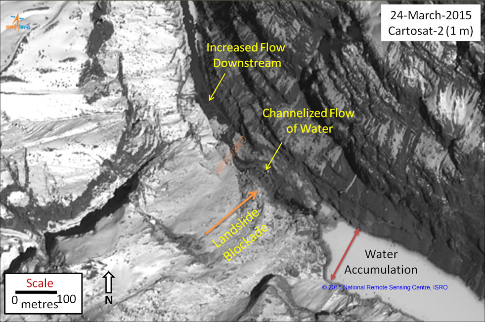
The dam was formed by a massive landslide (it is still not clear what exactly triggered that landslide) on December 31, 2014 when the river was still frozen. A joint task force of NDMA and all its supporting organisations including Central Water Commission, Geological Society of India, SASE, Military wings and local administration collectively had sufficient time and resources to take care of this 200 ft (equivalent to over 20 storey building) high landslide dam so that it does not burst suddenly and create damage and disaster in the downstream areas. The joint task force was authorized and directed by the National Crisis Management Committee (NCMC) chaired by the Union Cabinet Secretary Shri Ajit Seth, which met on Feb 20, 2015 and approved the Action Plan. The team flew to the area in March and on April 1, 2015 claimed to have successfully avoided the disaster, but it seems to have turned out to be a bad April fool joke. NCMC called it a National crisis, but it seems no one was even monitoring what is happening at the site.
The DAMage The dam on Phutkal River (also known as Tsarap River) at 13000 feet altitude was expected to burst on the onset of summer, and it did at 8.10 am on Thursday, May 7, 2015, leading to washing away of some three motorable bridges, ten suspension bridges located at different palces including Ichar, Padum, Tipting, Chah and Pipcha, numerous culverts, two school buildings, guest houses, residential houses, irrigation canals, pony treks and land pastures, as reported by The Tribune on May 9, 2015. This report mentions that 70-80% of stored water has been released, which means about 20-30 % of stored water is still held back, creating possibilities of future flash floods. Some 3000 people were evacuated from the 40 river bank villages in the 90 km stretch from the landslide dam to Padum (headquarter of the Zanskar sub-division of Kargil District) area as a precautionary measure. Fortunately there seems to be no deaths as far as news available so far[2]. The flood from the bursting of the 15 km long reservoir behind the landslide dam released over thirty million cubic meters of water and silt and led to damage to a school building too, it is reported. The Nimo Bazgo HEP of NHPC in the adjoining Leh District is in the path of the flood, it is not clear if it has suffered any damages.
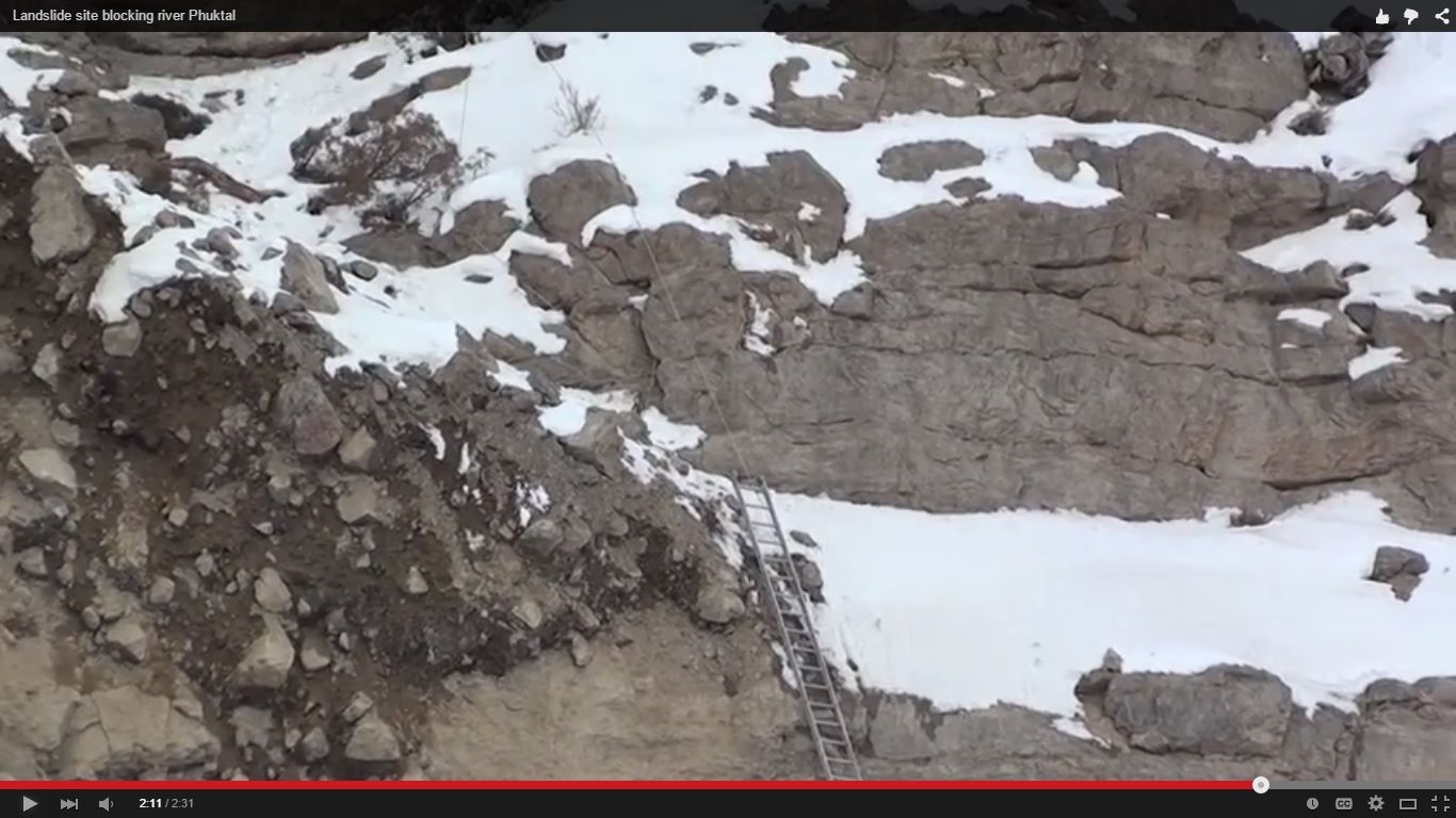
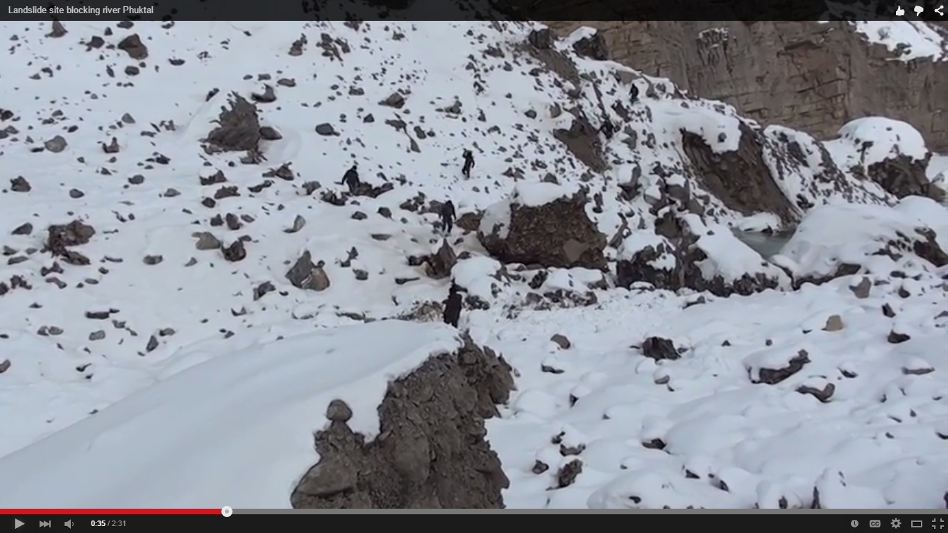
Unfounded April 1 claims On April 1, 2015 a joint task force of the Army, Air Force and NDMA had claimed, “A 75-metre-long channel, 2-metres deep and 2-metres wide, was created by controlled blasting using 175 kg of explosive, over five days after which an artificial channel was created through the landslide area that facilitated flow of water to the downstream side. Water finally started gushing across the landslide in an uninterrupted manner from the lake formed”. NDMA in fact reached the area only on Feb 8, 2015, almost 40 days after the breach. It took another 50 days to create the channel over the landslide dam which clearly proved grossly inadequate. It seems there was not even monitoring, local or through remote sensing as to how the claimed solution was working.[3]
After the claims of April 1, 2015, one newspaper headline[4] screamed: “Jammu and Kashmir: Major tragedy averted in Zanskar Valley” and claimed, “The successful completion of this operation is a testimony to the synergised efforts of the joint task force of Army, AF and NDMA in conjunction with the civil administration. Due to the joint efforts of the Army, Air Force, NDMA and the civil administration, a major calamity has been averted.”
After this claim of successful operation by Joint Task Force, the local leaders had warned, as reported by media on April 17, 2015[5] that the threat of flash flood continues to haunt the Zanskar sub division, but the central authorities did not show if they were doing anything about it.
Local leaders, angry at the neglect of the threat in the region, said: “the NDMA team comprising sectoral experts who were entrusted the responsibility to fix the problem had done shoddy work. Imagine making a channel of two meter depth, two meter wide in loose, rocky, sandy terrain and expect it to drain out discharge from glacier 50 meter thick 100 meter wide and 14 km in length. These experts of NDMA did not even apply common sense, forget about coming up with any scientific solution to it”.
Failure of NRSC The National Remote Sensing Centre is supposed to be monitoring the Phutkal landslide[6], but even after the dam bust, the latest images available on the NRSC website are for March 24. It seems NRSC too has failed to provide timely state of the landslide images. How can such delayed response from the National agency be useful or dependable in times of disaster?
In Conclusion This is clearly a bad failure of the NDMA and all the other organisations involved with it tackling this situation. The local people naturally feel cheated and deceived, by NDMA. The least one can expect is, as demanded by local leaders, an independent inquiry into this failure and a public report about this as soon as possible. The army will no doubt assess the failure of “OP PHUKTAL”, but that will be an internal exercise, what is required is an urgent, independent inquiry of the failure of the civil authorities led by NDMA, which also involved NDRF.
Such landslide dams can form all along the Himalayas. This failure of NDMA shows that NDMA is not in a position to tackle such disasters in future, which is a very worrying sign. In fact, it seems our neighbor Nepal is better equipped to handle such landslide dams, considering the way they handled the Sunkoshi landslide dam in August 2014[7], the dam was emptied with minimum downstream damage.
Himanshu Thakkar, SANDRP

POST SCRIPT: According to a report in The Tribune (http://www.tribuneindia.com/news/jammu-kashmir/another-flash-flood-hits-kargil-village/78313.html), a flash flood hit Sankhoo village, 40 km from Kargil town, causing flooding and damage at 3.30 pm on Friday, May 8, 2015, said to be caused by “melting of snow” which is clearly insufficient explanation.
END NOTES:
[1] For SANDRP’s earlier blogs on this event, see: Feb 1, 2015: https://sandrp.wordpress.com/2015/02/01/landslide-dam-blocks-zanskar-river-tributary-threatens-valley/; Feb 13, 2015: https://sandrp.wordpress.com/2015/02/13/landslide-dam-blocks-phutkal-river-threatens-zanskar-valley-update/ and Feb 21, 2015: https://sandrp.wordpress.com/2015/02/21/landslide-blockage-threat-in-zanskar-valley-to-continue-for-more-weeks-update-2/
[2] Some of the post burst news reports: http://www.risingkashmir.in/news/artificial-lake-on-phuktal-river-in-kargil-bursts/, http://www.tribuneindia.com/news/jammu-kashmir/lake-burst-ndma-under-attack-for-shoddy-work/77569.html, http://in.shafaqna.com/EN/IN/431687-Blocked-Phuktal-river-spills-over-floods-Zanskar-areas, http://www.dailykashmirimages.com/news-lake-burst-triggers-flash-floods-in-kargil-evacuation-on-78273.aspx#sthash.elVWPUZs.dpuf, http://www.downtoearth.org.in/content/lake-made-landslide-debris-bursts-causes-flash-floods-kargil, http://www.tribuneindia.com/news/jammu-kashmir/another-flash-flood-hits-kargil-village/78313.html
[3] NDMA has put up a video showing how difficult terrain was, see: https://www.youtube.com/watch?v=ZX39ON123iM and another one giving aerial view of the frozen reservoir behind the landslide dam: https://www.youtube.com/watch?v=W6Sdz9WPKQ8
[4] http://indiatoday.intoday.in/story/a-major-tragedy-averted-in-the-zanskar-valley-in-jammu-and-kashmir/1/426859.html
[5] http://greaterkashmir.com/news/2015/Apr/18/phutkal-glacial-lake-a-looming-disaster-mla-zanskar-30.asp
[6] http://www.nrsc.gov.in/Phutkal.html
[7] https://sandrp.wordpress.com/2014/08/02/massive-landslide-blocks-sunkoshi-river-downstream-nepal-india-under-threat/

Many things including the dates and periods given here are wrong. Without getting into facts it is easy to jump to conclusions. Many things that are posted here are not true and the disinformation is a work of people who wanted to make money out of it. Any logical minded person will appreciate the work of Army, Air force and NDMA team who despite of -35 degree temperatures ventured into making a channel in the landslide at a place which is practically inaccessible. Had the channel not been created the damages would have been far more. The water level indicator installed at Phuktal Monastery was the main reason of creating an alarm which activated the local administration and thus saved precious lives. Criticizing for sake of it makes no sense. Please get your facts right.
LikeLike
Thanks, for your response. All the information given here is from public sources, links for which are given there.
Unless you point out which facts are not correct and what are the alternative facts with source of information, it is difficult to substantiate the contention that there is attempt at spreading disinformation.
I totally agree that work done in difficult, inaccessible terrain and inhuman climate is certainly to be appreciated. Whatever critical outlook is there here is based on the damages that has happened following the flash floods. There is no information out there that said that the channel created was functioning and that there was a water level indicator installed at Phutkal Monastery, which helped alerting the downstream people and administration. Thanks for this information, I did not know that, but I have been monitoring as many as possible public information sources, but could not find this information anywhere! Thanks all the same, kindly let us know the sources for this and other helpful information.
LikeLike
Thanks
LikeLike
Hi,
Nice content! Thanks for sharing content and such nice information for me. I hope you will share some more content about Flood creates extensive damage
! Please keep sharing! And plse visit nadiyaparao.
Wildlife Resort Ramnagar
LikeLike