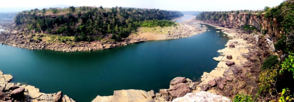
Above: Ken River in PTR – Glimpse of long deep gorge (Photo by RS Murthy, former Field Director of PTR)
Guest Blog by Hemendra Singh Panwar (Padma Bhushan, director of Project Tiger (1981-85 and first director of Wildlife Institute of India (1985-94)
My professional conscience impels me to make this submission, challenged as it is by the reliance on half-truths and misinformation by the Project proponents to justify environmental and wildlife clearances for Ken-Betwa River Linking Project (KBLP) from the State and Union governments. Let me at the outset clarify that I am not and have never been an activist even to promote conservation, though I did strive my best to this end within the system. I also have no phobia against dams and canals but do carry the conviction that ill-conceived such projects using wanton half-truths to present a mirage of unachievable benefits can but severely impact ecological and field conservation status while failing to deliver the claimed outcomes. Continue reading “What ails DPR and EIA of Ken-Betwa Link Project: A Note for EAC of MoEF&CC”→
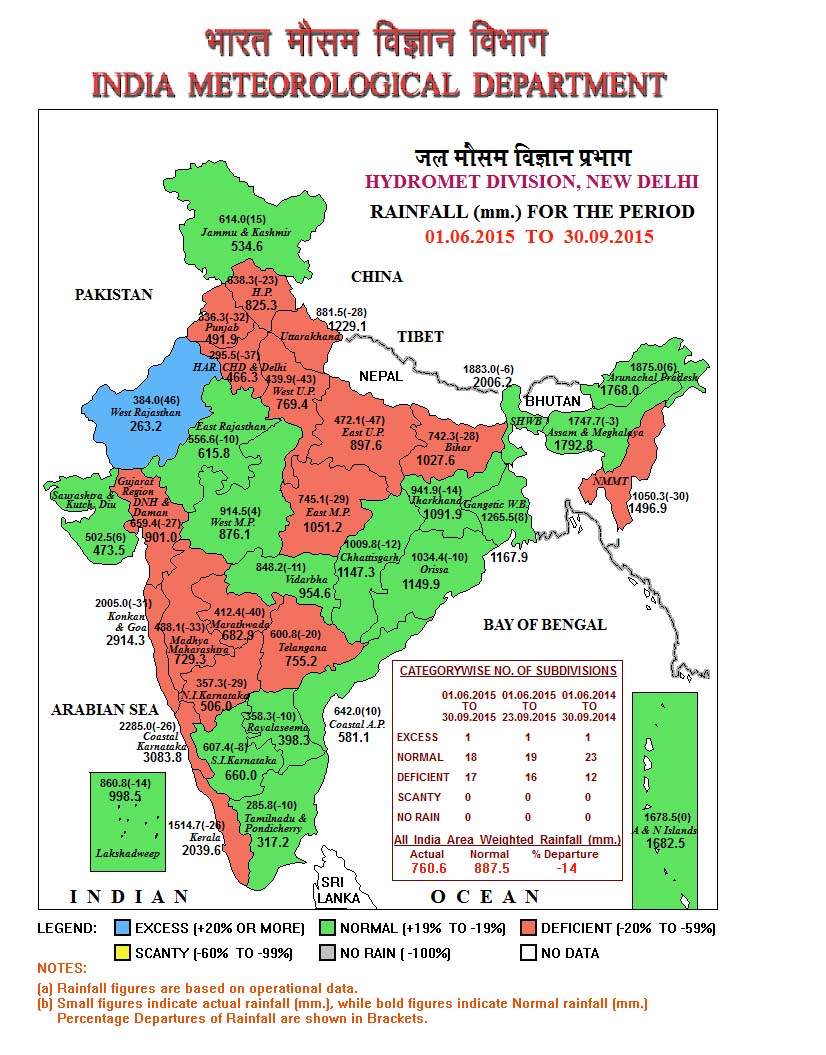
On Oct 26, 2015, Madhya Pradesh declared drought[1] in 33283 villages in 228 tehsils in 35 districts (of total of 50 districts), affecting 4.4 m ha area and 4.8 m farmers. It sounded a bit strange since Western MP, comprising of 30 districts, had above average rainfall as per IMD (India Meteorology Department[2]) figures for the 2015 monsoon (rainfall during June 1 to Sept 30).
Above: A fabulous view of Ken river. Nesting sites of Long-billed vultures are to the right. All will go under water if Ken-Betwa linkup is carried out (Photo by AJT Johnsingh)
PREFACE: Following is a submission by the authors to the Ministry of Environment and Forests’ Expert Appraisal Committee on River Valley Projects, sent on Oct 25, 2015, as the EAC was to consider the Ken Betwa River Link Project for Environment Clearance on Oct 27, 2015. The authors had sent a submission to EAC in Aug 2015, when the EAC considered this project for the first time. In response to the various submissions that EAC received on this proposal, including one by the authors and another by SANDRP, among others, the EAC had asked the project proponent, NWDA (National Water Development Agency, an organisation under Union Water Resources Ministry) to provide a point wise reply. The NWDA response can be seen here: http://environmentclearance.nic.in/writereaddata/Online/EDS/0_0_15_Oct_2015_1405329601eac.pdf
One has to wonder that if the Ken-Betwa is such a worthwhile project, why is it necessary for the proponents to lie and obfuscate facts in order to promote it. We are not unreasonable individuals and have no reason not to want people to be benefited by appropriate development. If the project had more overall benefit than detriment, why would everyone not support it. However we find that it is prejudiced, not argued on reason, much is being obscured and alternate views have not been taken into consideration. The project is being undertaken in an area that has been evaluated as important enough to set aside for the tigers’ welfare. High priority must therefore be given to this species; but throughout totally inadequate consideration has been given to this. Continue reading “Ken Betwa River Link Project involves India’s first Major Dam inside National Park: It needs, fresh, credible EIA, not misleading falsehoods from NWDA”→
The Environmental Impact Assessment (EIA) of Ken Betwa Riverlink project used for the public hearing to be held on Dec 23 (Silon village in Chhatarpur district) and Dec 27 (Hinouta village in Panna district), 2014 in Madhya Pradesh is, as can be seen from the details below, unscientific, incomplete, inadequate, biased, inconsistent (self contradictory), callous, making unwarranted conclusions/ assumptions, it accepts government claims uncritically and is generally a shoddy piece of work.
Background Agriculture Finance Corporation of India (now AFC Ltd) was commissioned in 2007 itself to conduct Environmental Impact Assessment (EIA) of Ken Betwa Riverlink proposal. This was even before National Water Development Agency (NWDA, a society of Government of India created in 1981-82 exclusively for studies on River Linking proposals) applied for the Terms of Reference Clearance for the EIA for this project in December 2010.
This review of the EIA of Ken Betwa project is based on the Executive Summary (English) of the EIA made available on the Madhya Pradesh Pollution Control Board (MPPCB) website in Dec 2014 before the statutory public hearing slated for Dec 23, 2014 at Silon village in Chhatarpur district and Dec 27, 2014 at Hinouta village in Panna district, both in Madhya Pradesh.
Since this executive summary is largely the same as the EIA made available to the Expert Committee set up on Inter Linking of Rivers (ILR) by the then Union Ministry of Water Resources (now Union Ministry of River Development, Ganga Rejuvenation and Water Resources – MRDGR&WR) for which I was a member, I have also provided the critique of that earlier EIA(in red font) in Annexure 1 to this Article[2].
The comments given below under each heading are only indicative to establish what is contended about the EIA here and not exhaustive.
Biased EIA In the very second paragraph of the EIA Executive summary[3], it is stated, referring to NWDA studies, “These studies established that Betwa is a water short basin”. But an EIA is not supposed to uncritically accept such assertions or assumption of the developer. In fact the EIA accepts this as gospel truth without critically examining it.
Incomplete EIA The EIA executive summary does not even have a project layout map, sections like biodiversity impact assessment, impact of destruction of substantial part of Panna Tiger Reserve, surrounding forests and livelihoods of the people dependent there on, options assessment, hydrological viability assessment, disaster potential assessment, how the project will be impacted by destruction of forests and climate change, additional green house gas emissions due to the project and downstream impacts, to name just a few issues..
EIA makes wrong claims The EIA claims in very second paragraph: “The scope of EIA studies inter-alia does not include water balance studies.” This is a wrong claim since water balance study of the Ken Betwa links establishes the hydrological viability of the project and by not going into the water balance study, the EIA has failed to establish hydrological viability of the project. SANDRP analysis in 2005[4] of the NWDA feasibility study of Ken Betwa Proposal[5] had established that the hydrological balance study of the Link Project is flawed and an exercise in manipulation to show that Ken has surplus water and Betwa is deficit.
As the collector of Panna district noted in 2005 itself[6], if the 19633 sq km catchment of the Ken river upstream of the proposed Daudhan dam (comprising areas of eight districts: Panna, Chhatarpur, Sagar, Damoh, Satna, Narsinghpur, Katni, and Raisen) were to use the local water options optimally, then there will not be any surplus seen in Ken river at the Daudhan dam site and by going ahead with the Ken Betwa Link without exhausting the water use potential of Ken catchment, which is predominantly a tribal area, the government is planning to keep this area permanently backward. But the EIA of Ken Betwa link does not even go into this issue, making the whole exercise incomplete.
Ken Betwa project destroys Panna Tiger Reserve but EIA claims project may benefit PTR! The Ken Betwa Project, as per the EIA, will submerge 4141 ha of Panna Tiger Park reserve, but the EIA Ex Summary says (para 58), “the reservoir may prevent encroachments of the park and invasion by livestock so that a relatively more secure and compact habitat is formed on Right flank of Daudhan dam which may be beneficial.”
In Para 63, the EIA executive summary goes on to claim that the project will not decrease tourists flow (due to destruction of Panna Tiger Reserve or drying of waterfalls in the downstream), but in fact increase tourist inflow because of the creation of reservoir! No word about the destruction of river!!
Absence of credible submergence figures The EIA has hugely reduced the area to be affected in Panna Tiger Reserve and in the surrounding forests compared to the figures given in the Feasibility report of the project, without any explanation. Well known conservation expert Kishore Rithe, in his article in December 2014 issue of Sanctuary Asia Magazine has raised doubts about these figures and has suggested that much larger area will be destroyed by the project than what is stated in the EIA. He has also said that the EIA does not take into account the biodiversity that will be destroyed in the forest because of the project. Using strong (& justified) words, he has said this is assassination of wildlife, to help the contractors.
EIA LIES on Biodiversity: Endangered and vulnerable species in Ken Basin find no mention in EIA Para 59 of the Ex Summary of EIA is about Aquatic Environment and it says: None of the species of aquatic plants come either under rare or endangered or endemic or threatened categories (REET). This is a shocking lie, since the following paper by Dr.K.D Joshi and B.K. Biswas of CIFRI (Central Inland Fisheries Research Institute) says that the Ken has at least 4 endangered and 9 vulnerable species. The EIA is also keeps mum about the existence of Ken Ghariyal Sanctuary in the downstream area, which will be destroyed due to the project.
CIFRI paper of 2010 said there are 4 endangered and 9 vulnerable fish species in Ken River According to a paper by Dr. K. D. Joshi and B. K. Biswas published in Journal of Inland Fisheries Society of India (42(2): 25-31, 2010) titled Piscine Diversity and Fisheries in the River Ken, proposed for the Inter-River Linking, “53 fish species classified under 40 genera, 19 families and 7 orders. Out of these, 51 species are native and 2 exotic. The river comprises some highly important threatened species including 4 endangered and 9 vulnerable species… The fish species available in the river have immense economic importance”.
Endangered species include: Tor tor (Mahseer), Chitala chitala, Eutropiichthys vacha, Ompok pabda.
The paper concludes that the proposed Ken Betwa link project will have “Deleterious impacts on piscine diversity and fishery may occur downstream to the Daudhan dam site in the river Ken, as a result of the depletion in breeding and feeding grounds and hiding sites of the fishes. This could be due to reduction in flow as a result of diversion of the water to the Ken-Betwa link.” The EIA has no word on this.
GEM of the EIA: Project canals help fish migration and will provide a ‘short cut’ for fish! This is indeed a GEM from the EIA executive summary. In para 59 the EIA executive summary says: “Interlinking of these basins through link canal will facilitate rapid migration of the fish easier… The fish has a tendency to migrate upstream. The inter linking of rivers provide another route for fish migration from Yamuna to Betwa and ultimately from Betwa to Ken. Further, the distance from Duadhan dam to the place of confluence of Ken with Yamuna is longer as compared to the distance from the place of confluence of Betwa with Yamuna and Daudhan dam through link canal. Thus, this route will facilitate rapid migration of fish.” This shows shocking ecological illiteracy of the EIA consultants. This para not only shows how poor is their understanding of fish, rivers and ecosystems, it also shows by AFCL should be blacklisted from doing any EIAs.
ANOTHER GEM FROM EIA: RESERVOIRS HELP REDUCE POLLUTION! In para 61 the EIA Ex Summary says: “Stagnated body can get rid of their pollutants by sedimentation while lotic body carries its load of pollutants downwards.” This narration of advantages of stored water as against flowing river clearly seems like a prescription that it is better to dam the river to reduce pollution! Another example ecological illiteracy of the EIA consultants.
Incomplete EMP The Environment Management Plan (EMP) in the EIA ex summary starting from para 66 is incomplete: It does not include environment flow assessment, muck disposal plan, compensatory afforestation plan, Compensatory land allocation for destruction of Panna Tiger Reserve, habitat improvement plan for the balance part of PTR, REET species plan mentioned in para 70(c) at cost of Rs 10 crores, upstream (of Daudhan Dam) water development impacts/ management plan, downstream impacts management, to mention only a few.
Outdated R&R Plan norms As stated in Paras 76 onwards, R&R (Resettlement and Rehabilitation) plan has been prepared based on norms of National R&R Policy of 2007 and MP R&R policy of 2002, but both are outdated in Dec 2014 where the applicable norms are based on The Right to Fair Compensation and Transparency in Land Acquisition, Rehabilitation and Resettlement Act, 2013. Thus the whole R&R plan is completely outdated and will need fresh assessment starting from Social Impact Assessment. The whole EIA has no mention of settlement of rights under Forest Rights Act. Thus the whole social impact and R&R section is outdated, incomplete and under estimated and hence unacceptable.
Fundamental contradictions in R&R figures Para 80 of EIA ex Summary says that 1585 families will be affected by the Daudhan Reservoir. In next para, this becomes population of 1585! Two paras latter, in para 83, the population affected by the reservoir becomes 7224! In para 92 the EIA executive summary says: “Therefore it is only 806 project affected families and there are no other affected families in the project affected villages.” This not only shows contradictions but absolute callousness of the EIA agency.
EIA says minimum agriculture wage is Rs 64/-! In para 94 the EIA executive summary says all the entitlement has been assessed based on agriculture wage rate or Rs 64/- of 2006-07! This is when the minimum agricultural wage rates for unskilled labourers w.e.f. 01.04.2014 is Rs 193[7], more than three times the rate assumed by EIA agency!
Joke of Land for Land by providing 5% of acquired land Para 96 of EIA Ex summary says that total of 6423 ha of revenue land is acquired and it is proposed to provide land for land to ST and SC families. Than it says for this purpose, a total of 358 ha of land will be required! This comes to 5.57% of acquired land and the EIA consultant says this is sufficient for providing land for land! This is clearly a cruel joke on the ST and SC families and shows how great an impoverishment programme this project is.
Social & Environmental impacts of backwater effect not assessed Para 67(c) says that 956 ha of land will be affected due to back water impact, but there is no social and environmental impact assessment of the back water impacts.
Contradictions in EMP
Para 59 says there are no REET species, and para 70(c) provides Rs 10 crores for REET species plan!
Para 70(a) says fisheries production from reservoir will be 470 MT / year and para 70(e) says the same will be 60 tons!
In para 70(a) the EMP says the reservoir fisheries will provide livelihood for 500 families and also that there will be sport licensing.
Questions over choice of AFCL for Ken Betwa EIA The Ken Betwa EIA work has been given to Agriculture Finance Corporation Ltd. (now AFC Ltd – http://afcindia.org.in/). Firstly, the basic mandate of this corporation is Agriculture Finance, and as we all know agriculture finance is in bad shape in India, one of the major reason for the agrarian crisis. In stead of focusing on its core area, this corporation has been majorly working on preparation of Environment Impact Assessment related work. Why should the government encourage such non core work by AFCL, [AFCL is itself is a quasi government body, it being owned by NABARD and EXIM bank]? Secondly, the track record of AFCL in EIA related work is quite bad. Some of the recent EIAs of AFCL that has invited adverse remarks include the EIA of Polavaram Multipurpose project (also one of the ILR links), Tipaimukh project in Manipur, Kameng Hydropower project in Arunachal Pradesh and Thoubal irrigation project in Manipur. In case of Tipaimukh and Polavaram EIAs, even some of the official agencies have found their EIAs to be wanting.
For example, the minutes of the minutes of the meeting of the Expert Appraisal Committee of the MoEF&CC for River Valley Projects, held on Oct 15, 2007 said that the EIA report for the Tipaimukh (even after several revisions spread over several years) “The revised EIA report incorporating the above mentioned information was considered by the committee in its meeting held on 15th October 2007. After careful examination of the report, the committee was of the opinion that the report has been prepared haphazardly… As such the data reported (flora and fauna) is of little value… No fresh study (on water quality) has been undertaken… No mention has been made about as to how many water bodies (ponds, lakes, Jheels, springs, etc.) are going to be submerged by the dam and what type of flora and fauna available there… The Biodiversity Management Plan as well as Fishery Management Plan are not up to the mark. Separate plan for rehabilitating the riverine species should be done. Fishery Management Plan does not say anything as to how measures will be taken for the conservation of the fish fauna occurring in the region. Instead, it talks about cultivation of economically important fish… Plan for the Biodiversity Management also needs significant improvement. IVI should be calculated for dominant species. Nothing has been said about the rehabilitation of mahseer (and similar other species), in spite of its endangered nature. The Financial outlay for both the plans has been prepared just as an eye wash and need thorough revision and enhancement of at least ten to fifteen times. The Biodiversity Management Plan is also having very small financial outlay. This also needs significant enhancement.” (Emphasis added.)
Cover Photo of B Tech paper by Chandan Bhavnani
CONCLUSION This analysis clearly shows that the EIA consultant does not have basic understanding of ecological issues related to rivers or river valley projects, ground situation in project area or laws of India. This EIA is clearly unacceptable and should be rejected. The EIA should be re-commissioned to a credible EIA agency. Appropriate steps should be taken against the current EIA consultants. The public hearing planned on Dec 23 and 27, 2014 should be cancelled as there is no basis for conducting an informed public consultation. This EIA and also the public hearing conducted based on this EIA will not stand public, scientific, social or legal scrutiny.
Ken Betwa River Link EIA from NWDA received in November 2009
WHY THIS EIA IS NOT ACCEPTABLE
This is in response to NWDA letter No.: NWDA(SCILR)/Tech-1/200/3/2006 (Vol.X)/67-86 Dated 23.3.10, requesting expert committee members to submit comments on the DRAFT Ken Betwa EIA, a soft copy of which was sent to the committee members in Nov 2009.
EIA AGENCY IS BIASED
In the very second para of the executive summary, EIA says Betwa is “Water short”. EIA agency is supposed to be unbiased and cannot parrot the assumptions of the developing agency, NWDA.
In para 1.02 (chaper 1, volume 1), it says, “It is noted that dams with reservoirs are among measures mostly resorted to as long term solution to mitigate flood losses as well as to prevent drought situations.” This is completely wrong statement, with no basis in reality, and in any case shows the bias of the agency at the outset.
In para 1.16 it says, “The anticipated benefits of the project include the following. The transfer of water to deficient areas from surplus areas;…” This clearly shows that the EIA agency has uncritically accepted the conclusion of the project developer, without so much as even an attempt to assess its correctness. How can such an agency be accepted as an objective EIA agency?
In Para17 it says, “There is no other alternative for irrigating the proposed CCA of about 3.436 lakh hectares, providing drinking water facilities to 16.98 lakh population and generating 78 MW power. This project is inevitable for removal of the backwardness and poverty of this Bundelkhand region of Madhya Pradesh. The no project option will adversely affect the development of this backward region of Bundelkhand and thereby increase the regional disparities. Such disparities contribute for large scale migrations from and unrest in the region. Therefore, no project option is an alternative to be considered.” Here again we can see the clear and repeated bias of the EIA agency. Firstly, the EIA agency does not even say what is the no project alternative. Secondly, it assumes that the project would remove the backwardness and poverty of the Bundelkhand region of MP, without any substantiation. Lastly, it says, no project option is to be considered!!! What does it mean??
EIA AGENCY IS INCOMPETENT
In para 14 of the Exe Sum, it says, “Out of the above, forest land accounts for to 5258 ha, rest of the area being agricultural lands, settlements, scrubs and water bodies. Ten villages are likely to be submerged. Area of Panna national park or Tiger reserve accounts for about 65.13 percent of total forest area under submergence with 4163 ha.” Simple calculation shows that 4163 is 79.2% of 5258, and not 65.13% as stated by the EIA. The EIA also does not explain why the forest land has reduced from 6400 ha in Feasibility report to 5258 ha and area of Panna tiger resevee has come down from 4586 ha in FR to 4163 ha now.
In Para 56 the EIA says, “The area (Daudhan project) under irreversible impacts is neither a home nor an important habit for the wildlife including birds”. To say this when the project is going to submerge over 4600 ha of Panna Tiger Reserve is shocking.
In para 58 EIA says, “Interlinking of these basins through link canal will facilitate rapid migration of the fish easier.” How can this become possible?
In Para 60 EIA says, “Stagnated body can get rid of their pollutants by sedimentation”. This is clearly wrong.
In Para 73 EIA says, “The budget for different management activities required to be carried out for mitigation and prevention of dam break is 60 lakh.”, However, none of the measures listed there can prevent dam break.
In para 1.04 it says, “In the nineteenth century British colonialism introduced technical and hydraulic principle by introducing perennial irrigation in the sub-continent… A third wave in hydraulic manipulation emerged in 1930s with new technologies put into operation to effect the virtual industrialization of river control. Now the entire river basin had become the focus for water planners and engineers. This facilitated to train the river through interconnected dams, reservoirs and diversions all the way to its estuary by harnessing its waters simultaneously for navigation, irrigation, flood control and power generation.” These statements make no sense and in any case are irrelevant and also show the ecological illiteracy of the agency and also its bias for such systems.
In para 1.10 it says, “The Gangau weir was constructed to augment supplies from Bariapur PUW for transferring the water from Ken basin to Betwa basin, as the construction of a reservoir is proposed at Daudhan village in Chhatarpur district. Before selecting the Daudhan site for construction of a reservoir, an assessment of two other alternative sites were considered.” Makes no sense. There are many other such paras and statements, but these samples should be good enough for any objective reader.
In Para 1.18 it says, “National Water Development Agency, New Delhi taken up feasibility studies of Ken-Betwa Link Project in Madhya Pradesh to cater to the needs of irrigation besides providing drinking water, power generation and diversion of waters to Betwa basin. Though there are large benefits that may accrue after assuring irrigation they are out weighed by social, environmental and economic costs.” (Emphasis supplied.) If the benefits are out weighed by the costs, than the project is non viable is it not? Why that conclusion is then not reflected in the rest of the report?
EIA INCOMPLETE
In para 66 (under Reservoir Rim Treatment) the EIA says, “The periphery line beyond the MWL will be in submerged condition for a few days only during flood period and will be vacant during other period.” No details are given as to how much area of which specific villages/ districts will be affected over how much period and what will be the impacts thereof.
EIA DRAWS UNWARRANTED CONCLUSIONS/ ASSUMPTIONS
Para 26 of Exec Sum says, “Due to drying up of leaves of trees, monkeys were found moving from one tree to another for their shelter in Panna Park near proposed Daudhan dam.”
In Para 40 it says, “Hence impact due to change in the hydrological cycle are not anticipated.” This is completely wrong, the hydrological cycle will change with the building of the dam and there will be impacts there of.
In Para 57 it says, “The Daudhan reservoir is capable of effecting the distribution of Tigers since the Tiger reserve of 4163 ha (National Park) will be submerged. But at the same time, the reservoir may prevent encroachments of the park and invasion by livestock so that a relatively more secure and compact habitat is formed on Right flank of Daudhan dam which may be beneficial.” There is no obvious logic to what the EIA says here.
In Para (on growth of aquatic weeds in reservoir) 59 it says, “The problems are manageable through bio-manipulation of reservoirs.” How can that be achieved and what will be consequences?
In Para 62 it says, “There are no places of tourist interest going to be affected due to the submergence.” This when the Daudhan dam will submerge over 4500 ha of Panna Tiger reserve, which is obviously a place of tourist interest.
In Para 66 (under compensatory afforestation) it says, “Assuming that non forest land is not available…” when the EIA is not supposed to make such assumptions.
In Para 69 the EIA talks about development of fisheries in Daudhan reservoir, without understanding that the most of the reservoir will remain under the forest dept and tiger reserve and such activities are not allowed in reserve area.
EIA MAKES CONTRADICORY STATEMENTS
In Para 69 the EIA says, “Funds to a tune of 1000 lakh are required for conservation of REET species in the submergence area.” However, earlier in para 57 it says, “…impact of the projects on REET species may not be too severe to prevent any recovery.” And in para 58 it says, “None of the species of aquatic plants comes either under rare or endangered or endemic or threatened categories (REET).”
In Para 69(a) the EIA says, “There is a proposal to develop carp based fisheries in Daudhan reservoir with an anticipated production of 470 MT/ year” and in para 69(e) it says, “Fish production from the reservoir will be increased steadily on a sustainable basis to attain a yield of 60 tones on full development by adopting the measures suggested.”
EIA AGENCY IS CARELESS
The EIA in para 34 says, “The Daudhan dam and reservoir area comprises of very hard, compact and dense quartz – arsenate”, but does not give any implications of the presence of dangerous Arsenate compound. According to Wikipedia, “An arsenate(compound) is any compound that contains this (AsO43−) ion.”[1]
The EIA says (para 4) that the Full reservoir Level is 288 m. When the FRL in FR was 287 m, the EIA should explain this change. It also claims that the MWL will be same as FRL, which is also a change from FR, no explanation is given.
EIA AGENCY USES WRONG TERMS
In para 39 it says, “No change in the regime of Ken River due to Daudhan dam or Betwa river due to Makodia dam is anticipated.” The line or the para does not explain what is meant by regime of river. If it means flood regime, since the para is talking about floods, its conclusion that there will be no change is completely WRONG. Such big reservoirs would completely change the flood regime downstream from the dams.
EIA Provisions are inadequate
In Para 91 the EIA provides for “Provision of land to land to the extent of land acquired, to the ST and SC PAFs.”. However this is completely inadequate. If the displaced population of Sardar Sarovar Dam from the same state of MP are entitled for minimum of 5 acres of irrigated land, why should the displaced population of Ken Betwa get anything less? All displaced families must get at least this.
The EIA does not indicate the R&R plan for the canal and other categories of displaced. This is also not acceptable. All categories of displaced must be treated the same way.
The R&R plan does not ensure improved and permanent livelihood for the displacement population. It also does not take into account the total resource base of the affected population, without which one cannot even assess if the affected people are better off or not.
THE EIA PROVIDES NO REFERENCES OR NAMES OF THE SOURCES OR EXPERTS IT USES IN THE REPORT. THIS MAKES SUCH FIGURES AND STATEMENTS UNVERIFIABLE AND HENCE UNRELIABLE.
The EIA also does not address many of the issues I raised following the earlier version of the EIA shared with the expert committee, this is pretty shocking too.
This brief note is sufficient to show why the current EIA for the Ken Betwa link proposal is unacceptable and the best course of action would be to go for a fresh EIA with a more credible agency. Pl include this note in the agenda of the 9th meeting of expert committee on ILR. This is not an exhaustive comment, but provides sufficient reason to reject this EIA and commission a fresh EIA from a credible agency, in consultation with the Expert Committee.
March 31, 2010, South Asia Network on Dams, Rivers & People (www.sandrp.in)
The public hearings required for the Ken Betwa River linking project (KBRLP) are to be held on Dec 23 and 27, 2014 at Silon in Chhattarpur and Hinouta in Panna districts of Madhya Pradesh. However, these public hearings violate fundamental legal norms in letter and spirit and should be cancelled and not held till these violations are rectified.
Firstly, the EIA (Environment Impact Assessment) notification of September 2006 clearly states that project EIA and EMP (Environment Management Plan) should be put up on the website of the Pollution Control Board a month before the actual public hearing. However, a perusal of the MPPCB website (http://www.mppcb.nic.in/) shows that the full EIA and EMP are still not uploaded on the website. When I talked with the concerned officers of the MPPCB, they confirmed that full EIA-EMP reports have NOT been uploaded on the MPPCB website.
Secondly, even the executive summary of EIA-EMP Report on the website is put up in such an obscure fashion that it is not possible for any common person to locate it. So I called up the phone number given on the MPPCB website: 0755-2464428. I was then told that I should call 0755 2466735 to talk to Mr Kuswaha about this. When I called Mr Kuswaha, he directed me to call Mr Manoj Kumar (09300770803). Mr. Manoj Kumar told me at 5.15 pm on Thursday, Dec 18 that he was already home and that I should call him at 12 noon next day. He however, confessed that even the executive summaries were not there about 15 days ago! When I called Mr Manoj Kumar next day and succeeded in connecting only after a few attempts, he told me that I need to first click on “Public Hearing” tab (Under EIA notification). On clicking this, one goes to a page with a table displaying various lists entitled List 1, List II, List III and List IV etc. Then one needs to click List IV. On clicking that one will see a list of projects from 469 to 601 and in that you go to project no 594 which is the Ken Betwa Project. There is no mention of the date of Public Hearing here.
I also called up Dr R K Jain (09425452150) at MPPCB regional office in Sagar, under whose jurisdiction Chhattarpur and Panna come to ask about the availability of the full EIA and EMP in soft copies. He said they are available at designated places, but about not being available on MPPCB website and available executive summaries not being properly displayed on MPPCB websites, he said that he is unable to do anything as that is happening from Bhopal.
When I told him that it is impossible for anyone visiting the MPPCB site to find this project and that the current public hearings need to be displayed more prominently, he hung up the phone, saying he has no time to answer such questions! In any case non-display of the public hearing date and executive summary in Hindi and English in easily searchable form is another violation of the EIA notification.
Thirdly, when we go through the Executive summaries in English and Hindi, we see that both are incomplete in many fundamental ways. The Hindi executive summary[1] has completely wrong translations. I could find nine gross translation errors in just first 16 paragraphs. The Hindi translation has not bothered to translation words like monsoon, MCM, PH, LBC, CCA, FRL, MWL, K-B, tunnel in first 16 paras, nor given their full forms. This makes the Hindi translation completely incomplete, wrong and unacceptable.
Fourthly, even the English (& Hindi) version of Executive summary on MPPCB website[2] is incomplete. It does not have a project layout map, sections like options assessment and downstream impacts.
Fifthly, the EIA claims in very second paragraph: “The scope of EIA studies inter-alia does not include water balance studies.” This is a wrong claim since water balance study of the Ken Betwa links establishes the hydrological viability of the project and by not going into the water balance study, the EIA has failed to establish hydrological viability of the project. SANDRP analysis in 2005[3] of the NWDA feasibility study of Ken Betwa Proposal[4] had established that the hydrological balance study in the Feasibility of the Ken Betwa Link Project is flawed and an exercise in manipulation to show that Ken has surplus water and Betwa is deficit. As the collector of Panna district noted in 2005 itself, if the 19633 sq km catchment of the Ken river upstream of the proposed Daudhan dam (comprising areas of eight districts: Panna, Chhatarpur, Sagar, Damoh, Satna, Narsinghpur, Katni, and Raisen) were to use the local water options optimally, then there will not be any surplus seen in Ken river at the Daudhan dam site and by going ahead with the Ken Betwa Link without exhausting the water use potential of Ken catchment, which is predominantly a tribal area, the government is planning to keep this area permanently backward. But the EIA of Ken Betwa link does not even go into this issue, making the whole exercise incomplete.
Sixthly, the Ken Betwa Link project is a joint project between Uttar Pradesh (UP) and Madhya Pradesh (MP), about half of the benefits and downstream impacts in Ken and Betwa basins are to be faced by Uttar Pradesh, but the public hearings are not being conducted in UP at all, the proposed public hearing is only in MP! Even within MP, the link canals will pass through and thus affect people in Tikamgarh district, but the public hearing is not being held in Tikamgarh district either.
Seventhly, the project had applied for the legally required Terms of Reference Clearance (TORC) and the same was discussed in the meeting of Expert Appraisal Committee (EAC) on River Valley Projects of Union Ministry of Environment, Forests & Climate Change (MoEF&CC) on Dec 20, 2010. However the public hearing is being held more than four years after EAC recommended the TORC and that is way beyond the normal term of two years for which TORC is valid and even for extended term of TORC of four years. The public hearing being conducted without valid TORC can clearly not be considered valid under EIA notification and hence there is no legal validity of this public hearing.
Eighthly, the EIA done by the Agriculture Finance Corporation of India was already completed when the project applied for TORC! I know this for a fact since copies of their (most shoddy) EIA were made available to the members of the Expert Committee on Inter Linking of Rivers set up by the Union Ministry of Water Resources in Nov 2009 itself. I having been a member of the committee had critiqued the shoddy EIA in April 2010 and this was also discussed in one of the meetings where the AFC EIA consultants were called and had no answer to the questions. The same base line data that is now more than five years old is being used in the EIA being used for this public hearing! This is again in complete violation of the EIA norms.
Ninthly, in a strange development, MoEF&CC issued TORC for the project on Sept 15, 2014, following a letter from National Water Development Agency dated 18.06.2014. This letter is clearly issued in violation of the EIA notification, since as per the EIA notification, the ministry could have either issued the TORC within 60 days of Dec 20, 2010 meeting of the EAC or the TORC would be deemed to have been given on 61st day or Feb 19, 2011. However, issuing the letter almost four years after the EAC meeting and that too without mentioning the deemed clearance is clearly in violation of the EIA notification.
The TORC letter on MoEF&CC website is also incomplete as it does not mention the Terms of Reference at all! They are supposedly in the Annexure 1 mentioned in the TORC, but the letter on MoEF&CC site does not include Annexure 1. When I asked Dr B B Barman, Director of MoEF&CC and who has signed the TORC letter, he said that the project has been given standard TORs for any River Valley Project. But Dr Barman forgot that the MoEF&CC was giving the TORC for the first ever interlinking of rivers project and the TOR for this unprecedented project CANNOT be same as any other River Valley Project. The TORC letter is invalid also from this aspect.
The MoEF&CC letter of Sept 15, 2014 is also without mandate for another reason. The letter says “Based on the recommendations of the EAC, the Ministry of Environment & Forests hereby accords clearance for pre-construction activities at the proposed site as per the provisions of the Environmental Impact Assessment Notification, 2006 and its subsequent amendment, 2009”. However, MoEF&CC seems to have forgotten here that the Daudhan dam site and most of the reservoir is inside the Panna Tiger reserve. Perusal of the 45th EAC meeting held on Dec 20-21, 2010 shows that EAC did not recommend preconstruction activity and the EIA division of the MoEF&CC that issued the Sept 15 2014 has no authority to allow pre construction activities inside the protected areas like Panna Tiger Reserve. Even the NBWL (National Board of Wild Life) Standing Committee meeting of Sept 14, 2006 allowed only survey and investigation and NOT preconstruction activity and in any case such activities inside protected areas cannot be allowed without Supreme Court clearance. It is thus clear that Sept 15, 2014 letter of MoEF&CC for Ken Betwa link is also without authority.
There is a third reason why the MoEF&CC letter of Sept 15, 2014 is legally invalid: the letter giving Terms of Reference clearance did not include the conditions EAC stipulated when it recommended the TORC in the EAC meeting of Dec 20, 2010. One of the conditions was that a downstream study will be done by Central Inland Fisheries Research Institute. This becomes particularly important since there is a Ken Ghariyal Sanctuary[5] which will be affected, as also the Raneh falls, both are also tourist attractions.
However, the EIA of the Ken Betwa links has no downstream impact assessment, no mention of Ken Ghariyal Sanctuary or Raneh falls. The EIA also does not contain the CIFRI study that EAC had asked for. This is yet another reason why this incomplete and inadequate EIA cannot be basis for the public hearing from Ken Betwa Project.
This article is not a critique of the EIA of the Ken Betwa Link, I hope to write a separate article for that. Here we only see how illegal is the Public hearing for Ken Betwa link to be held during Dec 23 and 27, 2014 in Chhatarput and Panna districts. The Ken Betwa link project itself is unviable and unjustified and should not be taken up at all. But that will need another article.
It seems the current Union Government under Mr Narendra Modi and Water Resources Ministry under Sushri Uma Bharti are trying to push ahead with their River Link agenda, putting aside even legal stipulations. They also do not seem to be bothered that the Ken Betwa link will only have adverse impact on Ganga and this will also affect the Ganga Rejuvenation that they say is their priority. The EIA does not say a word on this count.
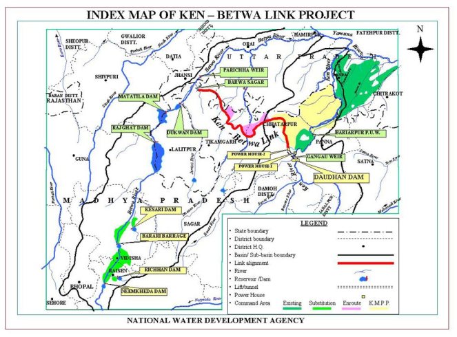
NWDA Index Map of Ken Betwa link proposal
We hope the proposed public hearing will be cancelled. In any case, any clearance given to the project based on such a public hearing will remain open to challenge.
Bahut kathin hai dagar chunav ki; kyo bhar lau pipe-link se ye mataki….
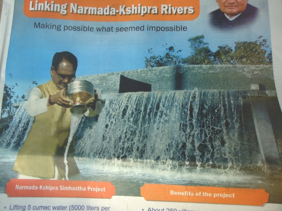
Hype vs Reality of Narmada Kshipra Pipeline Project
The Narmada Kshipra Simhastha Project is to be dedicated to the people of Malwa by former deputy Prime Minister L K Advani on Feb 25, 2014. Significantly, it is happening in absence of BJP’s Prime Ministerial candidate Narendra Modi.
The full page advertisement (going on daily during Feb 23-25, 2014 at huge public expense) and the hype that is being created by the Madhya Pradesh’s BJP government around pumping of around 5000 litres of Narmada water per second from a small Sisalia tank through 47 km long pipeline involving four stage pumping and releasing in the bed of dry KshipraRiver needs to be put in correct perspective. Madhya Pradesh government calls it river linking that too “the first-ever river linking project of the country” (see Madhya Pradesh Govt press release dated: Jan 9, 2013[1]). Such claims are not only a fraudulent presentation, possibly aimed to create a hype in view of the upcoming elections, but are factually wrong in many ways. In MP itself, Indore and Bhopal [both outside Narmada basin] have been getting water from Narmada river through such pipeline schemes for many years, Indore is now getting water through third phase of the scheme). More importantly, the project will not be able to deliver most of the benefits it claims.
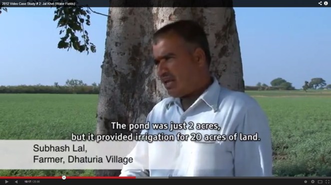
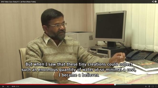
Dewas district collector Umakant Umarao explaining in Jal Khet film how RWH is the best option for the region and showed this on ground
The hype The Madhya Pradesh government claims this is “Making possible what seemed impossible”. It is not clear since when has pumping 5 cumecs water through piple-line become impossible in India. It is claimed to be “Realizing the dream of former Prime Minister Shri Atal Bihari Bajpeyi” (wrong spellings in the official MP govt advertisements). It is not clear when did Mr Vajpayee say that it was his dream to achieve pumping of some water through 47 km long pipeline. The project achievement, the advertisement claims: “First phase of restoring Malwa’s legendary prosperity successful”. This claim actually takes the cake and much more! What happened to Malwa’s legendary prosperity? Did they need piped water from another basin for that? How can such a limited quantity of water from another basin at huge cost achieve that?
Some over-enthusiastic MP government officials are claiming (see press statement dated Nov 27, 2012) that this project will also link Narmada with Ganga and some water from the project will go right upto Allahabad! It is just god’s grace that they did not claim it will also help Bangladesh in achieving greater food production!
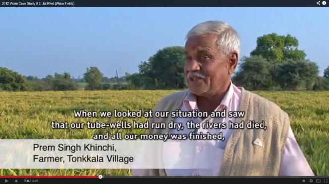
A farmer of Malwa describing the problem and solution, the result can be seen in the background, from film Jal Khet
The reality But first let us understand what this project is about. The water that will be pumped from Sisalia tank will reach there from NarmadaRiver: through one of the right bank canals of Omkareshwar dam. So the path of the water will be: Narmada river – Omkareshwar dam – common water carrier canal – right bank canal – Rising main of Omkareshwar project Phase IV – Sisalia tank – pump station (PS)-1 – Rising Main (RS pipe) 1 – BP Tank 1 – Gravity Main (GM) 1 – PS-2 – RM-2 – PS 3 – RM 3 – BPT 2 – GM 2 – PS 4 – RM 4 – tank – (Ujjaini village) Kshipra river. Secondly, how much of the water that is released from the dam will reach the consumers? There are no assessment of this in public domain, but considering the long path of the water even after reaching the Kshipra riverbed and considering huge evaporation losses and seepages into the dry riverbed and aquifers below, only a small fraction, less than a quarter of the water pumped, would reach the consumers.
The project claims it will provide drinking water to Dewas and Ujjain cities, over 250 villages along Kshipra river, supply water to Ujjain, Dewas and Pithampur and also recharge groundwater! Showing true intentions, agreements have already been signed with Delhi Mumbai Industrial Corridor for providing 90 MLD (or 25% of the 362 MLD water to be pumped in this scheme) water from this project to Pitampur industrial area in Malwa at the rate of Rs 26 per KL. That will leave very little water for other claimed objectives. Who will get how much water is a matter of assessments which are not in public domain. Moreover, in absence of credible wastewater treatment system and governance in place, more water for industry would mean more untreated industrial effluents into the Kshipra river, worsening the problems for the river and the people. (See: http://www.patrika.com/news/narmada-shipra-river-link-to-pithampur-sanctioned-by-dmic/958548, http://daily.bhaskar.com/article/MP-IND-special-purpose-vehicle-proposed-for-rs-200-cr-pithampur-water-supply-plan-4236793-NOR.html
)
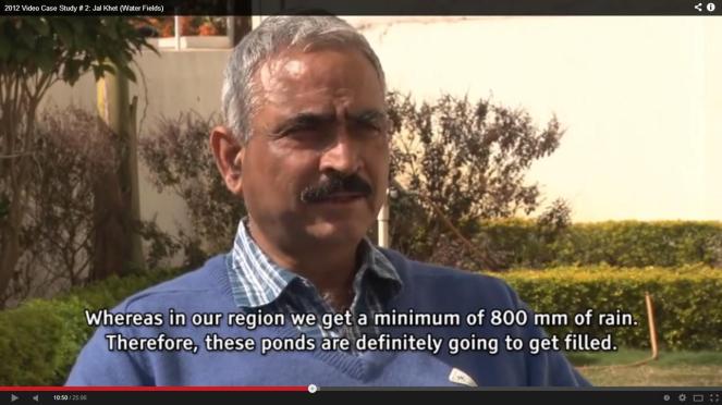
An engineer explains that ponds in Malwa would certainly fill up even at 400 mm rainfall, from film Jal Khet
Unaffordable cost of water Thirdly, this pipeline project involves pumping through 47 km long pipes that would raise the elevation of water by about 348 m from Sisliya (228 m) to Ujjaini (576 m) through pipelines of 1.8 m diameter. This involves use of at least 27.5 MW of power. The power bill of this project would be Rs 118.92 crores per year as per the MP Govt Public Relations Officer (PRO), power cost would be Rs 9 per KL for the pumping of 362 MLD (Million Liters per day). Even if 35% (very optimistic assessment) of the water were to reach the consumers, just the power cost of the raw water reaching the consumer would come to Rs 24 per KL (kiloliter). If we add the cost of maintenance, replacement cost, staff costs for the Narmada Kshipra Pipe Project (NKPP) and also the cost of treatment, distribution of the water to the consumers, the cost of the water that would reach consumer will multiply, would surely go much above Rs 50 per KL. Compare this to the water rate of Rs 5-10 per KL that average urban consumer in India is paying. Which of the rural or even urban consumer is going pay this kind of water bill? Here it may be added that the Rs 432 crores of the project cost is not even included in this water rate. More importantly, do we need this project for drinking water needs of Malwa? Such high head pumping schemes have proved unviable elsewhere too.
It maybe added here that Kshipra river is today in highly polluted state[2]. About 4 lakh liters of polluted water is entering the Kshipra river from Dewas city and industries, affecting villages of Ujjain, Dewas and Indore, and also Hirli dam and even groundwater. The Madhya Pradesh government has completely failed to ensure that such illegal dumping of polluted water is stopped. Now pouring this pipeline water to the polluted Kshipra water would only mean more quantity of polluted water.
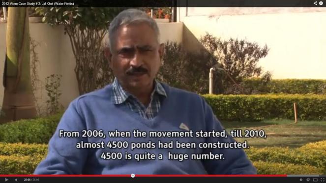
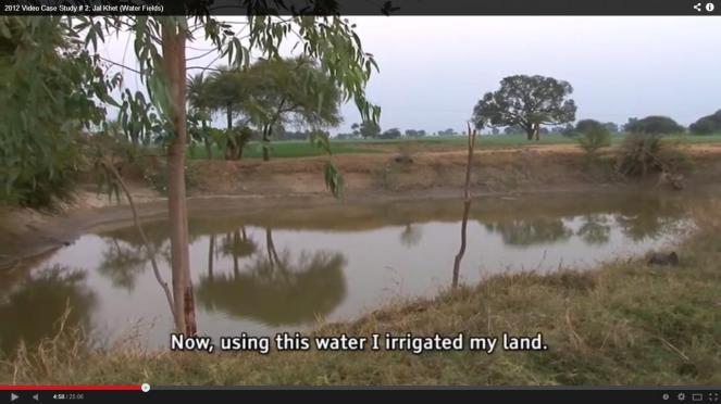
4500 ponds constructed in just four years, storing 100 MCM water, more water than what Narmada Kshipra pipeline will bring here at much higher expenses: Jal Khet film
Inappropriate use of Omkareshwar Project’s water and funds The administrative approval for the project dated Oct 19, 2012 says the cost of the project will be taken from Omkareshwar Project Unit II (Canals). Now this raises many questions. Firstly, it is clearly wrong to include the cost of the NKPP in the Omkareshwar canal cost. Secondly, this component was not included in the Omkareshwar project as approved by the Union Ministry of Environment and Forests, Central Water Commission or the Planning Commission. Adding this component to the Omkareshwar project would change the scope of the project and which should entail a fresh clearance from all these authorities. Thirdly, the Omkareshwar project canals get significant funding from Union of India under AIBP (Accelerated Irrigation Benefits Programme) and using that project money for such completely new component is clearly wrong, also from audit and accounts point of view. We are sure CAG will take due note of this and disallow such practices.
Similarly, diversion of water from Omkareshwar canal has angered the farmers and they have filed an Interlocutory Application in Indore bench of Madhya Pradesh High Court, asking for stay on inauguration of the project. While the HC has not provided a stay, it has remarked that command area of the project cannot be changed. As Rehmat of Manthan Adhyayan Kendra said, these projects are also creating new conflicts, which also happened in case of Veda dam in NarmadaValley. More conflicts are likely to come up in future.
A farmer in film Jal Khet explains how Malwa villages could prosper without the Narmada waters
No Impact Assessments, no participatory process There has been no social or environmental impact assessment for this project at any stage. The project also escaped need for environmental clearance using the loophole (which has been questioned for years now) that drinking water projects do not need environmental clearances and hence environmental or social impact assessment or management plans or monitoring or public consultations. In fact, since the project was funded from Omkareshwar project fund, use of that loophole itself is fraudulent. From the statements of the Madhya Pradesh Chief Minister Shri Shivraj Singh Chouhan, and former deputy Prime Minister L K Advani and others, they seemed quite sure about the project being beneficial. Why then they did not have any participatory processes and impact assessments? Incidentally, Mr Advani laid the foundation stone for the project on Nov 29, 2012, strangely at Ujjaini, where no significant work of the project was to happen, leave aside starting of the work where normally, foundation is laid! Did the project have inappropriate foundation?
A screenshot from film Jal Khet showing a rainwater harvesting structure in a village in Dewas district in Malwa
That the project had adverse impacts was apparent even from Govt of MP Press statement of March 21, 2013, which said: “Families who are growing water melons for generations at Kshipra river’s originating point[3] Sisliya reservoir urged Shri Agrawal to give them assistance since they will no more be able to grow water melons due to all-weather filling of Sisliya reservoir due to the project and their livelihood will be affected. Shri Agrawal assured to consider these families’ demands sympathetically.” It is not clear, what decision, Mr K L Agrawal, then chairman of NVDA, took about these and other affected people, it has not been brought out in public domain. There was also forest land affected in construction of the pipeline. There will also be issue of huge energy footprint and hence carbon foot-print of this water. These are only a few of the environmental issues related to the project.
The farm pond movement also led to reduction in electricity consumption, reducing carbon footprint, but the govt scheme is actually going to increase it manifold!
The project was in fact approval through a hurried process without any involvement of either the people of the NarmadaValley or the people of the Malwa. The introductory note[4] of Govt of Madhya Pradesh’s Narmada Valley Development Authority claims: “The Malwa region of M.P. had been reeling under acute water scarcity since about 3 decades. The ground water was plummeting at fast pace and experts had opined that if such conditions prevails, the whole Malwa region shall transform into a desert. The life line of M.P.-Narmada was the only option to feed the water to Malwa…” Similarly, MP Information Department Press Release[5] says: “…the Chief Minister concluded that the crisis can be solved only through Narmada water.” Amazing claims, since there are areas within Malwa that are even today have no water shortage, as can be seen from the screenshots from the film on water harvesting work done in Malwa. However, more importantly, is there anything to substantiate this standard “only option” theory? Why did the government not have a participatory process for arriving at such a conclusion? Also, if Malwa was once prosperous, without needing water from outside, why has it come to this stage now? Why not tackle those reasons? Why did Kshipra, a perennial, sada nira River became, seasonal, polluted River?
As Planning Commission member Dr Mihir Shah recently wrote, the 12th Five Year Plan proposes paradigm shift in Urban sector sector: “Each city must consider, as the first source of supply, its local waterbodies. Therefore, cities must only get funds for water projects, when they have accounted for the water supply from local waterbodies and have protected these waterbodies and their catchments. This precondition will force protection and build the infrastructure, which will supply locally and then take back sewage also locally.” The NKPP clearly violates this norm.
The chief minister, through full page advts is now projecting himself as Bhagirath, but the Malwa communities already got it from UN in 2012, from film Jal Khet
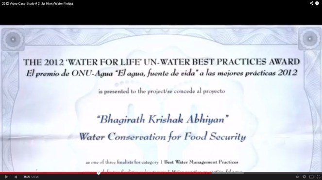
Story of proven alternative: Jal Khet However, this conclusion of There Is No Alternative (TINA for short) is typical phrase used by authorities to shut down any questions or debate. There are many Options for the Malwa region, but to see something that has been proven by the people of Malwa on ground, see a 25 minute film Jal Khet by Anjali Nayar[6], done for the International Water Management Institute, the film synopsis says: “In this awe-inspiring tale of innovation and courage, watch how the district administration joined forces with the villagers to bring water to this arid land. Soon the entire district would come under the throes of change in a massive effort to resolve its own problems, and many other fascinating and unforeseen changes would be discovered to have accrued. The perseverance of these people is a testimony to the enormous human capacity for resourcefulness and resilience.” Note that the district administration and the state were involved in this effort! Even the United Nations recognised this Bhagirath Krishak Abhiyan as best practice of water conservation for food security, as recently as in 2012. There should be no doubt that there are better alternatives than the Narmada Kshipra pipeline project.
The Bhagirath Krishak Abhiyan work was simple: create farm ponds in Dewas district villages in Malwa that will harvest rainwater and provide source for groundwater recharge, irrigation and drinking water. The scheme started on a slow note, but has picked up over the years and has led to construction of over 4500 ponds, recharging groundwater, increasing water and food security and making the people so confident that they say they will never have water shortage. The biodiversity in the area has increased, with lots of birds and some wild animals too coming to the area. While there could be some questions about the claims of the district collector and other government officials, there is little doubt that if such works are implemented with honesty and participation, they can bring significant change.
People started celebrating birthdays of talab and death ceremony of the tubewells in Malwa, from film Jal khet, but MP govt seems hell bent on imposing the pumps on the people
Is this Interlinking of Rivers? Is this part of ILR? The whole hype bringing in Vajpayee dreams etc seems designed to imply that the NKPP is part of the controversial and discredited interlinking of Rivers proposal. This is clearly far fetched and a major stretch on the credulity of all concerned, considering the scale, manner and cost of the ILR compared to a water pipeline project like NKPP. While it does involve transfer of some water from one basin to another for drinking water and the NKPP, like the ILR itself is of seriously doubtful justification, optimality, desirability and sustainability, there can be no comparison of NKPP with the ILR. Moreover, in ILR scheme of things, Kshipra, being part of Ganga basin, is surplus basin, and Narmada, claimed to be a deficit basin, is supposed to get water from Par and Tapi rivers! It seems we are seeing a case of Ulti Ganga here too, compared to ILR!
Watch the confidence of the people: No drinking water shortage EVER! (Jal Khet film)
But than MP is not new to working at cross purposes with the ILR project. It already did that in case of Mohanpura[7] and Kundalia major irrigation projects in Chambal basin in recent months. Both projects are part of PKC (Parbati-Kalisindh-Chambal, one of the five prioritized links of ILR) link of the ILR project, but MP is going ahead with the projects independently, jeopardizing the ILR link. And the Central Water Commission is in fact supporting MP in these machinations.
Model of sangam tirth from NVDA website
Next phase of Narmada Malwa link? The Madhya Pradesh government is saying that the NKPP is only phase 1 of a larger programme. In next phases, they hope to transfer water from NarmadaRiver to other tributaries of ChambalRiver like the Kali Sindh, Parbati and Gambhir. Those phases will involve much bigger transfer, much bigger impacts, costs and implications. However, the MP govt on Sept 27, 2013, gave in principle approval to full Narmada Malwa link at the cost of Rs 2375 crores and asked the NVDA to prepare Detailed Project Reports for these phases. The next phase is making impossible sounding claims of achieving irrigation to 17 lakh ha, drinking water to 3000 villages and 75 towns, in addition to water for industries!
The whole farm pond movement has led to change in heart of some govt officials, from Jal Khet filmThe whole farm pond movement has led to change in heart of some govt officials, from Jal Khet film
No information is available as to how much water is to be transferred (earlier estimates said 3 Million Acre Feet of water is to be transferred, requiring over 550 MW of power), in what manner and with what impacts. MP govt is clearly most undemocratic, non transparent and non participatory. There is an interesting clause in the administrative in principle approval, however. It says the project operation and maintenance expenses must be recovered from the farmers! Rehmat of Manthan Adhyayan Kendra based in Badwani suspects this is because the project is part of the application to the World Bank. Going by the first phase costs, the O&M (Operation and Maintenance) costs of next phase are going to be only higher! But farmers have no clue what they are going to be asked to pay! In no state of India are the farmers charged to completely recover the O and M expenses. In this project, it would clearly be impossible, considering the much larger O&M costs of this project compared to standard gravity fed canals. Is this than a ploy to create a water source of urban and industrial areas?
Photo from NVDA, showing part of the pipeline
However, besides requiring the statutory impact assessments and clearances, the next phase will also have serious inter state implications for the downstream Gujarat state (even NKPP will transfer 158 MCM of water). Gujarat sees NarmadaRiver and the Sardar Sarovar Project on it as its lifeline. The large no of projects that MP is building and planning to build on Narmada[8] is going to have serious implications for Gujarat. With hydrological basis of the Narmada Water Disputes Tribunal, on basis of which Sardar Sarovar has been designed, already in doubt, Gujarat would be wary of this. Now with these Madhya Pradesh plans of transferring water outside the basin, Gujarat would be very worried! And so would Modi! But as recent Madhya Pradesh decisions have shown[9], Madhya Pradesh is least bothered about downstream states.
Another screenshot from Jal Khet showing why the govt official changed his views
In fact, while the discredited ILR is included in Modi’s Lok Sabha elections agenda, he seems to be missing from the scene at this major ILR moment (Modi also completely forgot about it during his trip to North East, it seems, but that is another story!). May be, Gujarat’s worries at Madhya Pradesh schemes are somewhere a reason for this? It is clear, to paraphrase the words of famous qawalli of yester-years (with apologies to poet Sahir Ludhianwi), Bahut kathin hai dagar panghat ki… Full page advertisements at public expenses, making unfounded claims about river linking are much easier!
Himanshu Thakkar, SANDRP [We would like to acknowledge the useful comments provided by Shripad Dharmadhikary and Rehmat from Manthan Adhyayan Kendra and Parineeta Dandekar from SANDRP on an earlier draft of this note.]
Annexure 1:
Time line of Kshipra Narmada Pipeline Project
April 8, 2007 A global call floated by NVDA to invite EoI for selecting a consultant for DPR
Aug 8 2012 The approval of project was given by the CM, to be completed in one year
Aug 27, 2012 Tenders invited
Oct 12 2012 Official sanction for Rs. 432 Crore was accorded
Oct 19 2012 Approval letter issued
Nov 5, 2012 Contracts signed (not clear who are the contractors)
Nov 29 2012 Mr. L K Advani laid the foundation stone
Feb 25 2014 Project to be dedicated to the nation after time over run of 25%
The EIA of the Bansujara Multipurpose Project (BMP) dated May 2013 by WAPCOS has been submitted for Environment Clearance of the project before the Expert Appraisal Committee on River Valley Projects, in Nov 2013. WAPCOS is known to do very shoddy job of Environment Impact Assessments, this one is no different. In what follows I have given a few instances of wrong facts, contradictory facts, wrong calculations or assumptions, incomplete assessments, instances that shows it is cut and paste job and lack of options assessment by the 564 page EIA document. The conclusion is inescapable that the EAC and MoEF must reject this EIA and recommend black listing and other measures against WAPCOS. The project should be asked to get a fresh EIA done by a credible agency.
Location Map of Bansujara Irrigation Project
WRONG FACTS The EIA provides several completely wrong facts, here are a few instances:
1. River description On p 1-1 the EIA says: “The Bansujara Dam Project lies in Dhasan sub-basin of Betwa basin, River Betwa is a tributary of Yamuna river, rises in district Bhopal district at an elevation of 472 m. After traversing a length of 365 km, it joins Yamuna river in Uttar Pradesh. The river runs for nearly 240 km in Madhya Pradesh, 54 km along common border of Madhya Pradesh and Uttar Pradesh and 71 Km in Uttar Pradesh state before its confluence with Yamuna river near Hamirpur town in Hamirpur district of Uttar Pradesh.” This is actually the description of River Dhasan and not Betwa! It is exactly same as the description of river Dhasan given on the next page and several other places subsequently.
2. Land required for Canals In Table 2.3 it is stated that canals will require 44 ha land, this is clearly gross under-estimate considering even 49.9 km of main canal.
3.Private land under required for project The SIA says on page 1-2, “About 935.11 ha of culturable area, 57.49 ha of forest land and 4209.118 ha of other land including road, nallah, river, etc. will be affected.” This is blatantly wrong figure. On page 1-3/4 of SIA it is stated: “About 2935.11 ha of revenue/government land and 2894.37 ha of private land is to be acquired.” This again is wrong.
As the MoEF factsheet for the Forest clearance for the project says, “Apart from the 57.495 hectares of forest land proposed to be diverted, the project involves submergence of 287.951 hectares of government land and 4,856.276 hectares of private land.” Thus the suggestion by the SIA that only 935.11 ha of culturable land is going under submergence is clearly wrong since most of the private land is under cultivation in these villages.
4.How many families will be affected The MoEF Factsheet for the project says: “The project involves submergence of 21 villages. 2628 houses, 773 wells, 5082 trees, and 2628 families with population of 13,142 are getting affected due to submergence.” These figures are at variance with the figures mentioned in the EIA. For example, the SIA (p 1-4, repeated on page 4-1) says: “Over all 748 families of 9 Abadi Villages will be affected”. This when the project will be taking away 2628 houses as per the Fact sheet, is clearly gross wrong reporting of figures. Because of use of wrong figures, their R&R plan and R&R costs are also all wrong and gross under estimates. Moreover, now the R&R plan and costs should be as per the new Land Acquisition Act Passed by the Parliament, which has not been done in the EIA-SIA. As per the new Act, land has to be provided to each losing farmer, and this must be followed.
5. Completely impossible figures of crop yields A look at table 4.3 of SIA (repeated in table 7.1 of CADP) shows that the consultants have given crop yields before project (e.g. paddy 7 t/ha, wheat 18 t/ha, groundnut 10 t/ha and gram 10 t/ha) which are much higher than the average of even Punjab crop yields and they are expecting to double that post project! These are clearly impossible figures. This shows that the consultants are plain bluffing and seem to have no clue about possible crop yields and in any case do not seem to have done any surveys, but are only cooking up data. Amazingly, they are claiming that with 211% increase in crop yield, the profits from crops will go up by 318%! All this simply shows the manipulations they are indulging in to show the project is economically viable.
CONTRADICTORY FACTS 1.Main canal length Page 2-2 says main canal length is 90 km, the salient features on next page says Main canal length is 49.9 km.
2.Command area Tehsils and villages Section 10.2 of EIA (and again section 2.7 of the CADP) says: “The Command area of the proposed Bansujara Major Irrigation project lies within the district Tikamgarh in jatur and Baldeogarh tehsil” and than goes on to give details of these tehsils, but the rest of the document (e.g. section 6.1) says: “A total of 124 villages are likely to be benefitted by the project. 80 villages are located in Tehsil Khargapur of district Tikamgarh. About 13 villages are located in tehsil Jatara of district Tikamgarh. The remaining (31) villages are located in tehsil Palera of Chattarpur district.” Chapter 6 in fact provides full list of 124 villages in the command area. The subsequent details of the command area given in chapter 10 thus does not match with what is given say in chapter 6.
Contradicting this, page 1-4 of SIA says: “The Bansujara Multipurpose Project will benefit almost 132 villages in districts Tikamgarh and Chattarpur.” Amazingly, the SIA says Palera tehsil is in Tikamgarh district and not in Chattarpur district and that additional ten villages of Badamalhera tehsil of Chattarpur district will also be in command area!
Number of beneficiary villages in Palera tehsil are given as 31 in page 44 (chapter 6) and 30 on page 141 (chapter 11), with even names differing, e.g. Banne Khurd and Bastaguwan mentioned in chapter 6 are missing in chapter 11, village Bargram mentioned in chapter 11 is missing from the list in chapter 6.
All this is most callous and shocking. This fact alone should be sufficient to REJECT this callous EIA and recommend blacklisting and other punitive measures for WAPCOS as consultant.
3.Command area population Section 10.2.1 of EIA says: “As per 2001 Census the total population of the command area is about 38,000. The male and female population is 20,181 and 17,828”. However a look at the 10.2 that follows this sentence shows that these figures are for Jatara tehsil and not command area. Another sign of callousness.
4.Submergence villages Table 11.3 of EIA gives list of Project affected families, which is at variance with the list given in tables 10.8-10.14. Firstly, chapter 10 tables say that 14 villages of Tikamgarh Tehsil are affected, but table 11.3 lists only 13 villages. More shockingly, tables in chapter 10 say 6 villages of Bada Malhera tehsil of Chhatarpur district are affected, whereas the name of this tehsil given in chapter 11 is Bijawar. All this shows shocking callousness of WAPCOS.
5.Storage Capacity Page 11-10 says: “The storage capacity of Bansujara Reservoir is 539.42 Mm3.” This is clearly wrong, the figures for gross and live storage capacity given in salient features and elsewhere are: 313.1 MCM and 272.789 MCM respectively.
6.Water Availability As per Table 5.8, water availability at the project site from MP catchment (2788 sq km) alone is 843 MCM. Strangely, this reduces to 588.68 MCM in table 11.6 for whole of catchment (3331.776 sq km) at dam site. No explanation is given for these figures.
7.Submergence area While most of the document gives submergence area as 5201.71 ha. However, in section 2.7 of EMP, it says, “The submergence area of Bansujara Irrigation Project is 7476 ha.” This is amazing kind of contradiction.
WRONG CALCULATIONS/ ASSUMPTIONS 1.Field channel length grossly underestimated The p 6-6 of EIA says: “The Bansujara Dam Project envisages irrigation over a CCA of 54000 ha. In the areas where irrigation is proposed no field drainage, land shaping of field channels exist and used to be constructed. From general experience and existing practice, it is assessed that a length of 1600 m of field channels will be required to serve a chak of 40 ha of CCA. On this basis, an approximate network of total length of 180 km of field channels will be required for 50% of CCA proposed for irrigation.” Simple calculation suggests that the field channel length for 50% of CCA would be 1080 km (54000 ha / 40 ha per 1.6 km divided by 2 for 50% CCA).
2.Drainage requirement under estimated Section 6.9 (p 6-7) of EIA says, “The command area is being traversed by a large number of nallahs and drains, therefore field drainage should not pose any problem.” This is clearly wrong assumption since additional irrigation will certainly require additional drainage and cost calculations based on such flawed assumptions are bound to be wrong.
3.Baseless assumption about waterlogging Similarly about the assumption in section 6.13 (p 6-8): “Even after construction of Bansujara Dam Project the area will not face any waterlogging problem.”
4. Wrong claims about no floods The conclusion about flood and back water impacts is completely unfounded in section 6.14 (p 6-8): “As per information gathered from the Collectorate Tikamgarh there is no village affected due to back-water of Dhasan and Ur rivers. The existing drainage system in the command is adequate. The statistics gathered from collectorate Tikamgarh show that there is no flood affected area. The command has fairly good flood disposal capacity and not special measures are called for.” This when the Maximum water level of the dam is full 1.4 m above the FRL, the back water level is found to be high. This is also particularly relevant in flood prone basin like Betwa-Dhasan.
5.Drainage characteristics of clayey soils ignored The assumption in section 7.1 (p 7-1) shows complete lack of understanding on the part of EIA consultants: “The area is sloping gently and near its outfall into Betwa river, the slope is of the order of 0% to 3%. It is traversed by small drainage channels at short distances and they help in draining excess water efficiently. Hence, no provision for drainage has been made. The soil is generally clayey.” It is well known that clayey soils are inefficiently draining soils and to make such assumption for clayey soils is clearly wrong.
6.Unrealistic assumption of irrigation efficiency System irrigation efficiency of 54% assumed in Table 11.10 is clearly wrong, no project in India has achieved such high efficiency. The water loss will surely be much higher than the assumption of 105 MCM on page 11-14. The conclusion on that page that: “The quantum of water not being utilized is quite small and is not expected to cause any significant problem of waterlogging” is clearly wrong and baseless, since water logging also depends on many other factors including drainage, soil structure, underground geology, among other factors.
7.No industries, but 19.4 MCM for industries! The CADP (page 5-7) clearly states: “At present there is no industrial requirement in the area.” And yet the project allocates 19.4 MCM water for industries. This again shows that the project is being pushed even though there is no need for it.
INCOMPLETE ASSESSMENT 1. Dependence on fisheries incomplete It is not clear what is the area from which fisheries assessment done as reported in section 9.11.6. How many people depend on fish, what is the production market and economy of the same is also not reported.
2. Hydrology figures without basis Chapter 11 (Table 11.6) assumes that “For use on u/s of Bansujara dam for environmental and ecological balance and Misc. uses by surface water” is 10 MCM and “Quantity of water reserve for d/s release for environmental and ecological balance” is 15.18 MCM and that groundwater available upstream of dam site will be 58.86 MCM (10% of surface water). No basis is given for any of these and all these (and many other) figures given in the water balance are clearly ad hoc, unfounded assumptions. The groundwater availability is typically 40% of total water availability, so around 67% of surface water availability. Why should it be 10% in case of the Dhasan basin is not explained and in any case does not seem plausible.
However, in Table 2.2 of EMP, the environment flow suggested in monsoon months is 12.8 cumecs. This would mean that the project would need to release 132 MCM of water in four monsoon months as environment flows, when they have assumed in hydrology that only 15.18 MCM water is required for this!
3.Incomplete SIA SIA says (SIA page 1-7) that it has selected certain of the 21 villages facing submergence due to the project. Actually the SIA should have done full survey of all the villages not a sample of villages.
4.Impact of loss of river not assessed It is expected that the SIA will assess the impact of loss of river for the people in submergence and downstream zone, but no such assessment has been done. Even in section 4.4 of SIA on “Impacts of Socio-Cultural Environment”, there is no mention of impact of river (or forest or other natural resources) on the people.
5.Full Canal details not given The EIA or CADP report does not provide the full lengths of main canals, distributaries, minors, field channels and field drains, including their width, land requirements, protection measures like canal like plantations etc. Without these basic details, the EIA or the CADP cannot be considered complete.
6.Command area coinciding with command area of Ken Betwa Link canal and other such projects? A perusal of the Command area of the Ken Betwa River Link Project (TOR approved by EAC in its 45th meeting in Dec 2010) shows that all the three Tehsils (namely Baldeogarh or Khargapur in Tikamgarh district, Jatara Tehsil in Tikamgarh district and Palera Tehsil in Chhattapur district) are also benefiting from Ken Betwa Link Canal. A look at the map of the command area of Ken Betwa link canal and that of the Bansujara shows that some area are certainly common. The EIA of Bansujara should have pointed this out and also if the proposed command area is to benefit from any other such projects, but it has not done that.
CUT AND PASTE JOB? Several parts of EIA raises the suspicion that they are cut and paste from other documents. This suspicion is proved correct when we see this sentence in Table 12.2 in Disaster Management Plan (Chapter 12 of EMP): “All staff from dam site, power house & TRC outlets alerted to move to safer places”, since the Bansujara project has no power house or TRC (Tail Race Channel). The consultants forgot to remove these irrelevant aspects while doing the cut and past job[1], it seems. This is just by way of illustration.
Similarly, the title of the section 2.6 of the Command Area Development Plan says it all: “2.6 FOREST TYPES IN THE MOHANPURA PROJECT AREA”. Here again it is clear that while doing cut and paste from another EIA, the consultants forgot to change the details! There is also the sentence “Tehsil Shajapur has maximum population density of 238 persons per sq.km. (2001 Census data)” on page 2-6 of CADP, but there is no mention of any such Tehsil in the area!
NO OPTIONS ASSESSMENT The EIA does not contain any options assessment. In fact section 10.2.4 shows that 19174 ha of the 48157 ha of cropped area in the command is already irrigated. This means a substantial 40% of the command area is already irrigated.
On page 3-5 of SIA it is mentioned that out of 318 land holding respondents in the SIA survey (in submergence villages), only 4 had unirrigated land. This shows that land of over 99% of respondents is already irrigated.
Very shockingly, the report does not mention what are the levels and trends of groundwater in the catchment and command of the project. When Groundwater is India’s mainstay for all water requirements, not give this full picture of groundwater makes the report fundamentally incomplete.
The area has average rainfall of around 1100 mm and thus more area can get irrigated with better use of this rainfall and such a huge dam with such huge submergence (5202 ha) and land requirement (5887 ha, gross underestimate considering that land for canals are not properly assessed), over 25000 people displacement (at least and that too only from submergence area) and other impacts is not the best option.
CONCLUSION What is listed above is not an exhaustive list. Nor are these some typographical errors, but these show serious incompetence, callousness and worse. The conclusion is inescapable that the EAC and MoEF must reject this EIA and recommend black listing and other measures against WAPCOS. The project should be asked to get a fresh EIA done by a credible agency. The EAC in the past have failed to apply its mind about such shoddy EIAs even when this was shown to EAC through such submissions. Most recent such case is that of the Mohanpura Irrigation Project in MP, in which case too the EIA was done by WAPCOS. It is hoped that EAC will apply its mind to this issue and make appropriate recommendations.