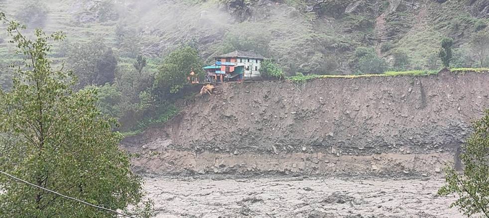
Salun village, perched roughly 50 feet above the Ravi River, had its moment of fame on the 26th August 2025 — a moment that also became its last. On the dark, rainy afternoon, the small village with homes, rajma fields, apple orchards and cattle sheds collapsed into the flooded River Ravi like a house of cards. In a matter of 30 minutes, ancestral homes with warm hearths, blankets for the coming winter, old report cards and wedding albums, adhar cards and bankbooks-entire archives of living-were erased. Villagers, who managed to escape in time stood in awe and saw their village going extinct before their eyes.
Continue reading “The Day Salun Village Fell: Impacts of Cascading Hydropower Projects in the Ravi Basin”Tag: floods
Bundelkhand: Overview of 2025 Monsoon
Bundelkhand is known as a drought prone region. It is comprised of 7 districts of Uttar Pradesh and 6 districts of Madhya Pradesh. The region is known as drought prone region in recent years. Let us see the situation of 2025 SW Monsoon rain in Bundelkhand.
Continue reading “Bundelkhand: Overview of 2025 Monsoon”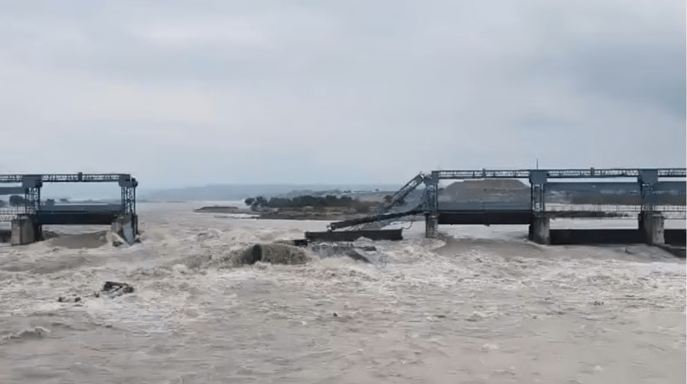
Punjab Floods 2025: Role of Bhakra, Pong and Ranjit Sagar Dams
Every dam can potentially help moderate floods to some extent in the downstream area. This is possible only when the dam is operated with that objective in mind. However, when the dam is NOT operated with that objective and is filled up as soon as there is water available, the same dam can in fact bring avoidable flood disaster in the downstream area.
This is exactly what has happened in Punjab ONCE AGAIN during the 2025 SW Monsoon. This has happened on numerous occasions in the past including in 1978, 1988 and 2023, for example.
Continue reading “Punjab Floods 2025: Role of Bhakra, Pong and Ranjit Sagar Dams” Guadalupe River Floods: Understanding the tragedy along ‘The Most Dangerous River valley in the USA’
Guadalupe River Floods: Understanding the tragedy along ‘The Most Dangerous River valley in the USA’
“This is the most dangerous river valley in the United States, we deal with floods on a regular basis.” – Kerr County judge, Rob Kelly about Guadalupe River[i], 5th July 2025
“If you live in the Guadalupe River Basin, you also live in one of the three most dangerous regions in the U.S.A. for flash floods!”[ii] – Opening Statement of “Staying safe: A Guide to Flooding in the Guadalupe River Basin[iii]” published by the Guadalupe River basin Authority
Flash Flood Watch Alert from National Weather Service received 3 hrs 21 minutes ahead of the devastating “30 feet high tsunami ball of water[1]”.
“If you do not want to be flooded, do not build or live in a floodplain”– Guadalupe-Blanco River Authority
And yet, several summer camp buildings built on not only floodplains, but on extremely dangerous floodways[iv]. more than 27 children lost to floods.
Continue reading “Guadalupe River Floods: Understanding the tragedy along ‘The Most Dangerous River valley in the USA’”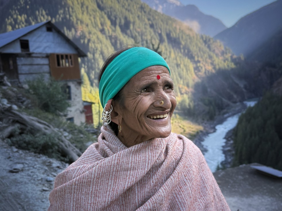
The Moon River: People’s Story of Chenab
Chenab, which translates as the Moon River is the largest of the five tributaries of River Indus. It flows for about 974 kilometers from the High Himalayas of Lahaul to the forests of Jammu and Kashmir and onto the plains of Pakistan. Its main tributaries in India include Miyar, Marusudhar and Tawi. In the vast plains of Punjab in Pakistan, it is met by Jhelum, Ravi and Sutlej to form the mighty Panjnad before it meets the Indus. Its catchment, spread across 67,430 km2, is shared between the two countries.
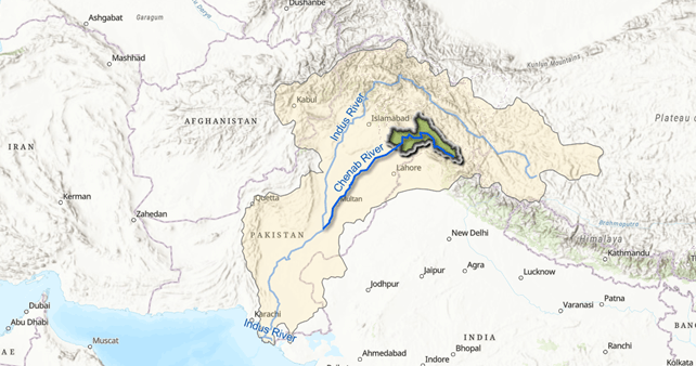
Chenab is Chandrabhaga (Crescent Moon) in its headwaters. It was the River Asikni in Rigveda, and the Acesines for the ancient Greek. From sparse mountain settlements of Lahaul to the bustling urban centers of Sialkot, more than 10 million people live and prosper along the Chenab. Hydropower projects operational and under constructions on the river have an installed capacity of more than 5000 MW (Central Electricity Authority 2024), and its canals irrigate hundreds of thousands of acres in Pakistan and India (Shakir et al).
Continue reading “The Moon River: People’s Story of Chenab”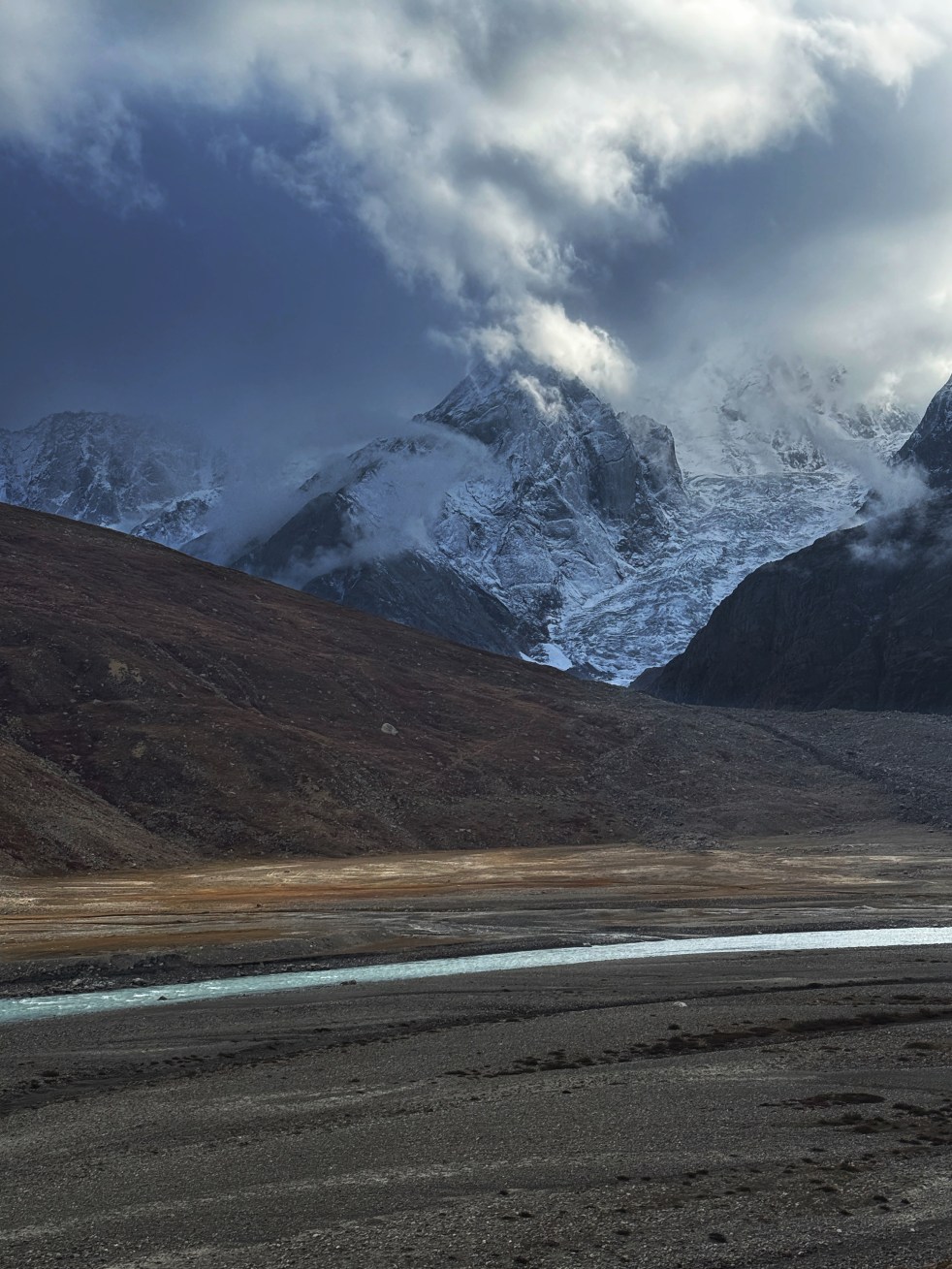
Hydropower-GLOF Nexus in Chenab Headwaters: Absence of credible studies and accountable governance
Increasing incidences of Glacial Lake Outburst Floods (GLOFs) are being experienced in the Indian Himalayas. One of the most notable examples of GLOF was the Chorabari Lake GLOF that occurred on 16th June 2013 in Kedarnath, Uttarakhand[1] which was triggered by heavy rainfall induced mass movements into the lake. The GLOF devastated villages of Kedarnath, Rambara, and Gaurikund. Around 6,000 people were officially killed, and a significant number of the deaths were linked to the GLOF. Countless bridges and roads were washed away, and about thirty hydropower plants were affected or completely devastated. Several Hydropower projects resulted in exponential losses to life and livelihoods. Whole of Uttarakhand was affected in the disaster, and a significant proportion of it was related with GLOF.
Continue reading “Hydropower-GLOF Nexus in Chenab Headwaters: Absence of credible studies and accountable governance”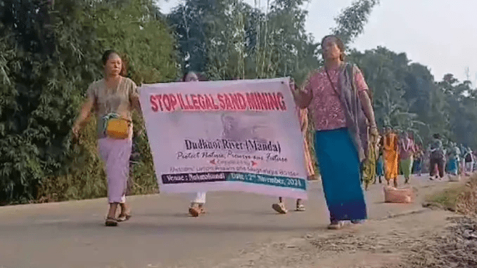
DRP 251124: Protest by Mothers Union against sand mining along Assam-Meghalaya border
(Feature Image: Mother’s Union protest rally against sand mining. Image Source: Nagaland Post, 03 Nov 2024)
The ongoing protest by the Mother’s Union against sand mining in Dudhnoi River along the Assam Meghalaya border has brought to focus the serious implications of unsustainable sand mining, whether legal or illegal. The campaign has wide based support from the Garo Students Union, All Bodo Students Union, Krishak Mukti Sangram Samiti and other groups.
The campaign has highlighted that due to use of motorized equipment to extract sand, the water level in the Dudhnoi river is dropping hugely, including during rainy season. The campaign has also pointed out that the forest, mining, transport and police departments have been allowing over loaded sand laden dumpers with or without proper challans.
Continue reading “DRP 251124: Protest by Mothers Union against sand mining along Assam-Meghalaya border”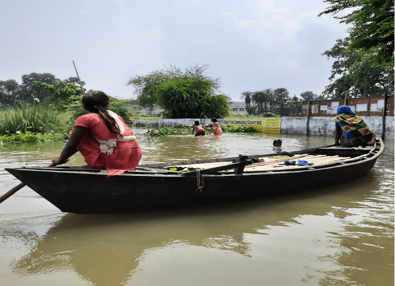
Frequent 2024 Floods in Bhagalpur-Bihar
Guest Article by: Dr. Ruchi Shree
In 2024, Bihar received 19 percent less rainfall than the normal rainfall and one of its districts named Bhagalpur even lesser with 29 percent. From 1 June to October 21, this district of South Bihar situated on the banks of the Ganga received merely 713.8 mm rain while the expectation was 1054.3 mm according to India Meteorological Department figures. It is the third consecutive year when Bihar has received lesser rainfall than expectation[i] and it is likely to worsen the water scenario in the coming years. On the other hand, Bihar faced severe flood this year and Bhagalpur was one of its worst affected districts due to a rise in the level of the Ganga. In a span of around 45 days i.e. from mid-August to end of September, Bhagalpur faced floods four times. This writing is based on my observation of three locations in Nathnagar block of Bhagalpur — two villages named Dildarpur and Biharipur and the Tilka Manjhi Bhagalpur University (TMBU) premise (administrative wing and Lalbagh Professors’ Colony). TMBU is quite close to Dildarpur village (situated on the Diyara land between Champa Nalla/River and river Ganga).
Continue reading “Frequent 2024 Floods in Bhagalpur-Bihar”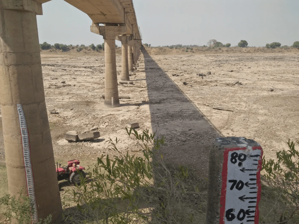
Yamuna Manthan 050924: Changing parameters of Ken-Betwa Project needs fresh appraisal?
(Feature Image: Dry Ken river beneath bridge at Pandvan in Amanganj, Panna in April 2018. Image taken during Ken river walk by SANDRP & Veditum India)
The controversial Ken-Betwa Interlinking project is undergoing several changes being proposed by central and state governments of UP and MP. Firstly, there are plans to build two new barrages at Pailani and Banda and renovate Beriyapur and Pariksha weirs and Barua Sagar dam apart from renovation of 15 dams and large ponds in Mahoba district. Then, the construction of a 21 km link channel will require 271 ha of forest land.
Similarly, the CM of MP has requested to increase irrigation capacity of Patne-Biarma Irrigation Scheme from 90,100 ha to 2,50,000 ha under the interlinking plan. On the other hand, the CM of UP has suggested inclusion of Hamirpur district in the plan.
Continue reading “Yamuna Manthan 050924: Changing parameters of Ken-Betwa Project needs fresh appraisal?”
DRP 010724: Time for independent review of Polavaram Project?
(Feature Image: Work going on Polavaram Project at Polavaram in West Godavari. DC Image: Narayana Rao, Dec. 2020)
The sequence of events over the last two decades that ended this week with white paper on Polavaram project being released by the newly elected Andhra Pradesh govt underlines urgent need for an independent assessment of the multi-state Polavaram Project on Godavari River in Andhra Pradesh.
The story of the project similar to, though a bit longer than that of the ill-fated Kaleshwaram Project of the neighbor Telugu speaking state of Telangana. Both are ill-conceived, expensive, high impact projects on same Godavari River, both taken forward without sufficient studies and implemented without sufficient checks and balances.
Continue reading “DRP 010724: Time for independent review of Polavaram Project?”