“This is the most dangerous river valley in the United States, we deal with floods on a regular basis.” – Kerr County judge, Rob Kelly about Guadalupe River[i], 5th July 2025
“If you live in the Guadalupe River Basin, you also live in one of the three most dangerous regions in the U.S.A. for flash floods!”[ii] – Opening Statement of “Staying safe: A Guide to Flooding in the Guadalupe River Basin[iii]” published by the Guadalupe River basin Authority
Flash Flood Watch Alert from National Weather Service received 3 hrs 21 minutes ahead of the devastating “30 feet high tsunami ball of water[1]”.
“If you do not want to be flooded, do not build or live in a floodplain”– Guadalupe-Blanco River Authority
And yet, several summer camp buildings built on not only floodplains, but on extremely dangerous floodways[iv]. more than 27 children lost to floods.
Hundreds of children sleeping about 500 feet of a river known to be tempestuous, in a month which has seen the highest flood waves in the past. Children who did not have access to their phones, who did not have access to siren or alerts, who were not moved to higher grounds after Flash Flood Watch alert came in. It is unclear if the dire warning, Flash Flood Emergency issued at 4.03 am reached them. “This is a PARTICULARLY DANGEROUS SITUATION. SEEK HIGHER GROUND NOW!”.
“The fact that Kerr County officials and others say, “We didn’t know it was coming” is either the height of negligence or a demonstration of total incompetence.”[v]– Austin Meteorologist Jim Spencer
“Blame is “the word choice of losers,”[vi]– Gov. Greg Abbott of Texas when questioned whether he would call for an investigation into possible failures surrounding the deadly floods, which include a lack of state and local spending on flood control measures and warning systems.
Till now, the death toll of Texas Hill Country Floods has crossed 120, many of them children, with more than 160 people still missing.[vii] It is feared that the death toll will reach 250[viii], making it one of the starkest flood disasters in the US.
I’ve been living in the Texas Hill Country for about 8 years and have traveled several times across the length of the Guadalupe River through its headwaters in Kerrville, Hunt, to Guadalupe River State Park and River Road, its middle reaches where San Marcos River joins it and its mouth in the Matagorda and San Antonio Bay, where Guadalupe meets the Gulf of Mexico.
We have witnessed the recent drought and low water levels in Guadalupe and its tributaries like Blanco, Comal and San Marcos with concern and have experienced the flashy nature of the river where the water table rises with little or no warning. The ravages of 2015 floods along the Blanco River in Wimberley are still visible and a reminder of why this region of Texas Hill country is known as the Flash Flood Alley. Turn around, Don’t Drown is a sign that is a constant companion across low water crossings. Almost everyone here is aware of the volatile nature of the land and its rivers, more so the landowners, ranchers and farmers who live with the land.
All this makes the unprecedented death toll in the recent Hill Country Floods difficult to accept and comprehend.
At the same time with the onset of monsoon, flashfloods in Himachal Pradesh in Indian Himalayas have already claimed more than 70 lives. Bhoti Kosi in Nepal is in spate and has claimed 11 lives so far. [ix]
Across prosperous and not so prosperous corners of the world, flash floods are here to stay. How prepared are we? The death toll in Texas is a disturbing reminder that even in the best equipped regions, same things make a difference between life and death: respecting the floodway of a river, state-of-art forecasts, specific warning and alerts, last mile reach of warnings, vulnerable groups being kept away from dangerous sites and funding towards local communities to set up early warning systems in remote regions.
What follows is an overview of Hill Country Floods along the Guadalupe River mainly during 3rd-6th July 2025.
Guadalupe River
Guadalupe flows for about 390 kms through the heart of the Texas Hill Country. In the upper reaches where the flood-ravaged Kerr County is located, Guadalupe is considered as “one of the highest rated recreational and scenic rivers in Texas and is Kerr County’s central asset.[x] The river is lined with RV camps, summer camps, river tubing facilities, all of which are especially crowded during holidays like the 4th of July weekend this year. In the drought-prone Texas, flowing rivers and green riverbanks are extremely attractive magnet for people to come together.
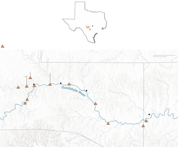
There is network of 29-gauge sites between Kerr County to Port Lavaca where Guadalupe meets Gulf of Mexico.[xi] It has a large dam named Canyon Lake 68 mts high and 2080 mts long in its middle reach.
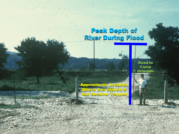
Guadalupe is no stranger to floods. The river has experienced major floods in 1936, 1952, 1972, 1973, 1978, 1987, 1991, 1997 and 1998 and this is only with limited data available. Its major tributary Blanco River in Wimberley flooded catastrophically in 2015 taking 13 lives.[xii] While 1998 floods claimed 12 lives, the 1987 Guadalupe flood resulted in the tragic death of 10 teenagers when a bus and van leaving a church camp encountered the flood waters in an attempt to evacuate a flooded region (https://www.weather.gov/ewx/wxevent-19870717)
That was in July too.
Most of the deadly floods here occur at night or early hours of the morning “Due to tropical nature of the air and atmospheric physics at play“, as Meteorologist Horwitz puts it.
“1998 Flood was the flood that many thought would never happen. But floods are not predictable. They do not follow measured cycles. They destroy homes, businesses and take lives. Unfortunately, an even greater flood will occur sometime in the future.”‘
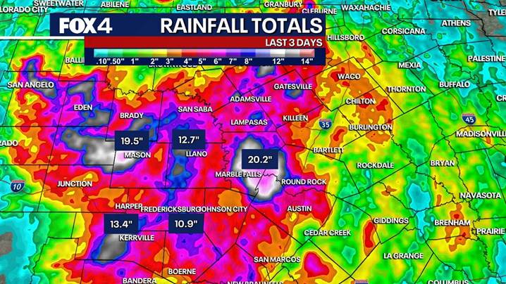
Truly enough, in the early hours of 4th July 2025, about 10-12 inches rain fell in this region by a slow-moving storm system.
4th July Weekend Floods
Dalton Rice, Kerrville’s city manager, explained how the Guadalupe River flooded so quickly.[xiii] “When you look at the headwaters of the Guadalupe, there’s a north and a south fork. Since 1987, under normal conditions, you’ll hit water in one of those areas, and those two forks will converge into the Guadalupe, which comes through the city of Kerrville. This rain event sat on top of that and dumped more rain than what was forecasted on both of those forks. When we got the report, it was about 7 feet or so on the south fork, and within a matter of minutes it was up to 29 feet, and all of that converged at Guadalupe.”

Slow moving storm system on 4th July Weekend
While the tropical storms around July are robust but fast moving, this time around the storm did not dissipate soon. It was fed by the remnant moisture of a tropical storm Barry and Hurricane Flossie. What developed over Texas was known as the Mesoscale Convective Vortex. The steering currents were low around this with steady flow of moist air from the south. All this combined into a system which caused upto 6″ or more rain per hour in some areas.
Rapid rise in the River
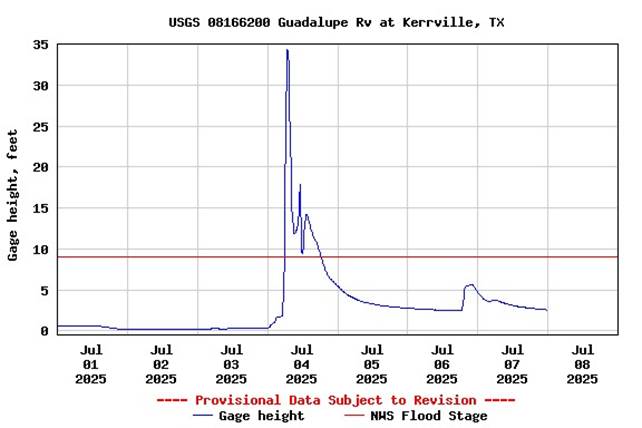
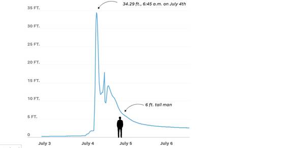
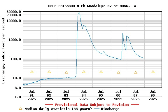
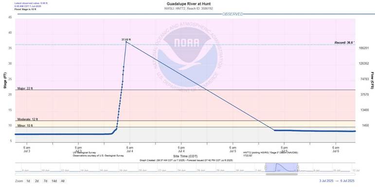
According to KCTV Meteorologist Mike Nicco,[xv] the average depth of Guadalupe River at Kerrville is about 2 feet. It rose to 5 feet in 15 minutes, 9 feet in 30 minutes, 26 feet in 45 minutes and within a hour and a half, it was 34 feet high. It reached flood stage in just 30 minutes. This shows how rapidly the river rose and how limited the time was to respond and move to safer grounds once the process started.
The average daily flow of the river at Kerrville is about 1.56 cusecs (cubic feet/sec) average day. On the 4th of July, during the flood, it reached 134,000 cusecs. The river almost quadrupled in size.

Warning or Alerts
It is being said that the residents received no warning of the flash flood and there was very little time to respond as the waters were rising “more than one foot per minute” in RV parks close to the river as told by survivors.
However, National Weather Service (NWS) issued a Flood Watch Alert on Thursday afternoon (3rd July afternoon) and NOAAs Weather Prediction Centre released a discussion about a worrying “mesoscle precipitation event” on the 3rd July evening around 6 pm. Even then it was impossible for meteorologists to predict exactly how much rain will fall where and the actual event exceeded the worst-case scenarios of the models used.
Timeline of Flood Alerts as per NOAA Scientist Jeff Masters and Meteorologist Bob Henson [xvi][xvii]:
- A Flood Watch was issued 1.18 pm on 3rd July, more than 15 hours ahead of the disaster, by the National Weather Service in New Braunfels, TX, for parts of eight counties, including hard-hit Kerr County. The watch warned that localized rainfall amounts could reach 5 to 7 inches by 4th July morning.
- A Flood Warning went into effect for parts of Bandera and Kerr counties 1.14 am on 4th July It warned of “life threatening flash flooding” at locations that included Kerrville, Ingram, Hunt, and Waltonia. The warning also noted that the damage threat was “considerable” – a tag that automatically triggers Wireless Emergency Alerts on cell phones.
- A Flash Flood Emergency was issued for south central Kerr County, including the town of Hunt, at 4.03 am on 4th July. The warning noted, “Numerous low water crossings as well as the Guadalupe River at Hunt are flooding. Between 4 and 10 inches of rain have fallen.”
- A Flash Flood Emergency was issued for locations along the Guadalupe River from Hunt through Kerrville and Center Point at 5.34 am on 4th July, with the note that “Automated rain gauges indicate a large and deadly flood wave is moving down the Guadalupe River. Flash flooding is already occurring.”
- It remains unclear whether or how the overnight warnings made it to the people most at risk – a classic “last-mile problem.”
“The heartbreaking catastrophe that occurred in Central Texas is a tragedy of the worst sort because it appears evacuations and other proactive measures could have been undertaken to reduce the risk of fatalities had the organizers of impacted camps and local officials heeded the warnings of the government and private weather sources, including AccuWeather,” AccuWeather Chief Meteorologist Jonathan Porter.[xviii]
Children’s Camps along the Guadalupe River
Several Children’s Camps are situated on the banks of Gudalupe River in its headwaters. Some of them are nearly 100 years old and are a beloved legacy of Texas. However, the event has raised pertinent questions about the location of these camps and the steps taken to move children to safety, especially about its oldest and most famous camp, Camp Mystic where 27 young girls and teenage counsellors are now confirmed to have died.
Camp Mystic[xix]
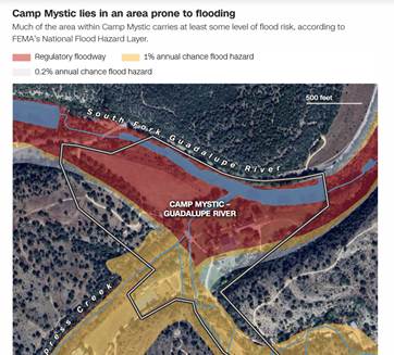
Camp Mystic is an extremely popular private Christian summer camp for girls situated along the banks of Guadalupe established in 1926. There are three primary gauges with a robust historical record near Camp Mystic, none of which had been above flood stage during the summer camp dates in the last 17 years[xx].
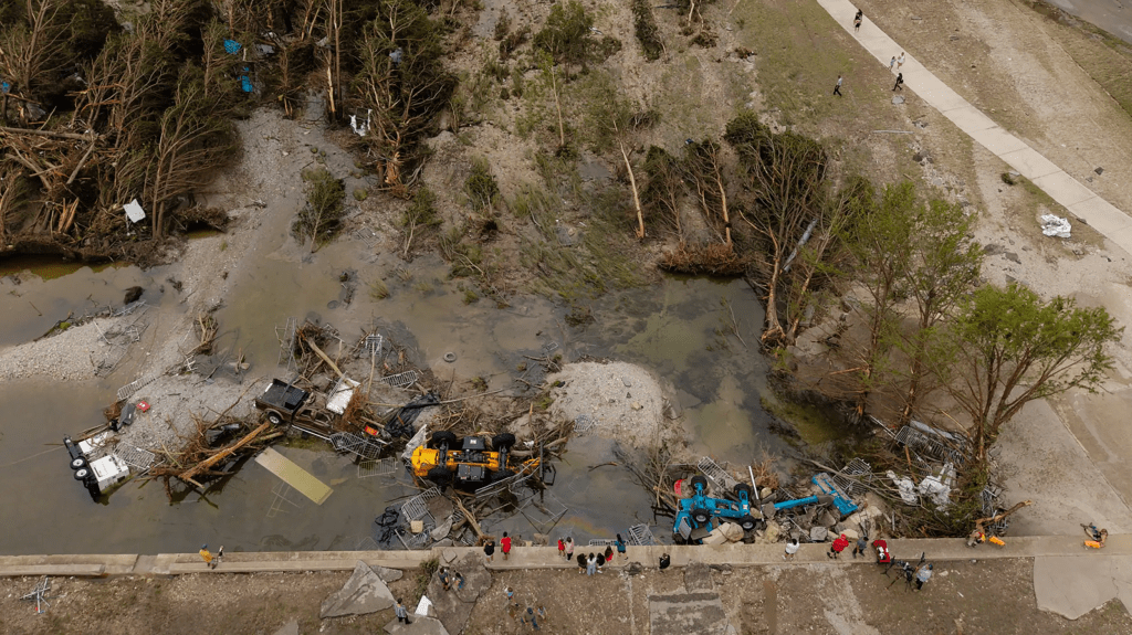
However, several girls who went missing after the floods were in the low-lying cabins on the “Flats,” where junior and intermediate campers live, less than 500 feet from the riverbank.[xxi]
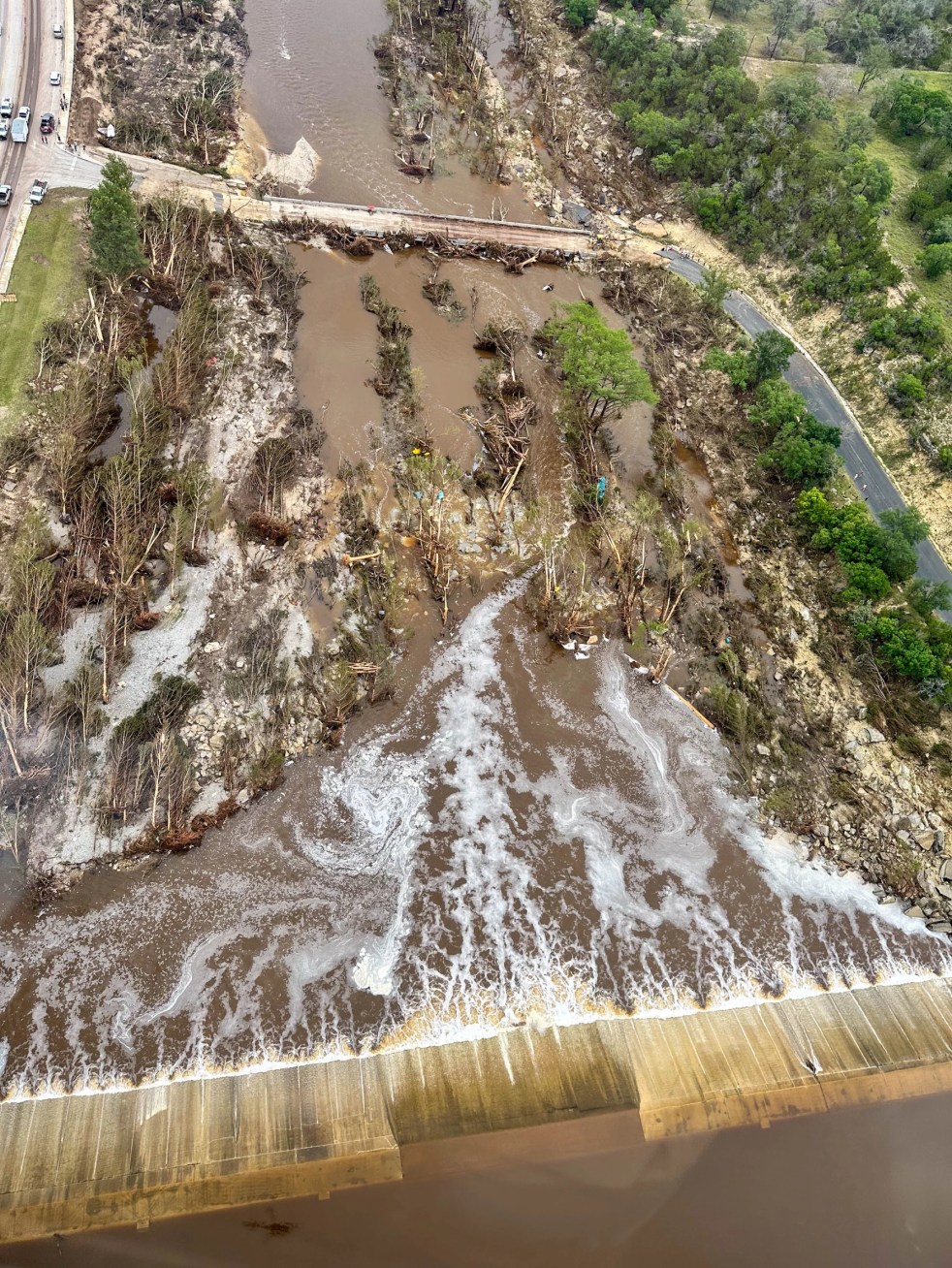
The quickest flood gauge level rise recorded during Friday’s event was on the Guadalupe River at Comfort, Texas, 20 miles east of Camp Mystic. That river gauge rose 30 feet in 75 minutes, with the river spiking 12.93 feet in 15 minutes Friday morning. That’s 10.34 inches per minute or an inch every 6 seconds,[xxii] which is also verified by survivors. The river gauge on the Guadeloupe at Hunt, Texas, 6 miles northwest of Camp Mystic, rose nearly 30 feet in six hours, peaking at 37.52 feet, the highest on record, beating the previous high of 36.6 feet set in 1932.
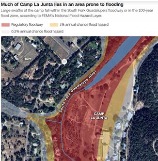
Major part of Camp Mystic lies inside Regulatory Floodplain as is clear from the images below. It is now said that it was not only on Floodplain, but also the floodway, one of the most dangerous sites for flood wave to pass.
Flood Warning and Alerts to the camps and its residents
- The strongest Flash Flood Emergency Warning issued by the NWS was at 4.03 am when most people were asleep
- The kids at Camp Mystic did not have their phones with them as per the camp policy
- Mobile network coverage is spotty in the region and alerts could not have reached some groups
- Youngest kids were sleeping closest to the river, about 500 feet away from the river
- There were no independent Sirens or alerts which alert the community. There was a proposal in 2017 to install such an alert system, but it did not receive funding, and it is reported that the community did not approve it as it was costly.[xxiii]
All the above factors together meant that there was no way reliable and independent warning could reach the affected population including the over-700 children at Camp Mystic.
For a region known as the Flash Flood alley, which has seen past two highest recorded flows in July, which knows just how dangerous Guadalupe can be, this is a very serious lapse and cannot be condoned easily.
Whether staffing cuts/ budgetary cuts affected forecasting ability
Again, Jim Spencer the popular Austin Meteorologist states:
“Currently at our local National Weather Service office, due to early retirement packages to reduce its budget/personnel and a hiring freeze there are:
*Warning and Coordination Meteorologist position open (yes they coordinate Warnings)
*2 open meteorologists positions open (yes they are on call 24/7)
*Hydrologist position open (yes, they project floods)
*Electronic Tech position open
*Manager position open
So, I don’t know — you tell me.”[xxiv]
This is as evident as it can get.
There is a robust discussion about whether the staff cuts and budget cuts affected the warning around this tragedy. Evidently, there is need to strengthen these institutions and systems further and not weaken them. USA is fortunate to have great historical data, records, analysis, models, and forecast abilities. Many countries do not have that and will need decades to develop it. It will be foolhardy to weaken one of the most important assets of the country.
FEMA (Federal Emergency Management Agency), housed in the Department of Homeland Security, plays a major role coordinating complex emergency operations involving federal, state and local agencies. NOAA (National Oceanic and Atmospheric Administration) provides vital disaster alerts through the National Weather Service, potentially affecting weather forecasts and climate research. Since January, more than 200 employees at FEMA have been cut, and 1,000 employees at NOAA have been laid off by the Trump Government. (PBS[xxv] and Statescoop[xxvi])
Five former Directors of NWS, both Republican and Democrat, said in an open letter on May 2, 2025: “Our worst nightmare is that weather forecast offices will be so understaffed that there will be needless loss of life.”
In its report dated May 13 20225, Scientific American explained How Trump’s National Weather Service Cuts Could Cost Lives. Weather experts warn that staff cuts at the National Weather Service that have been made by the Trump administration are a danger to public safety as tornadoes, hurricanes and heat loom this spring and summer.
Sirens and Flood Warning System not funded[xxvii]
8 years ago, Kerr County officials had considered installing a siren system on the Guadalupe after the deadly floods in Wimberley. But a commissioner voted against an initial study and other officials had doubts if the community would pay for such a siren system. In the words of Tom Moser, a Kerr County commissioner at the time who pushed for a new system, “We can do all the water-level monitoring we want, but if we don’t get that information to the public in a timely way, then this whole thing is not worth it.”[xxviii]
In Conclusion
We are hence left with a situation where hundreds of people and children have succumbed to a flash flood in one of the most prosperous states in the most prosperous country of the world. There were warnings provided which possibly did not reach the people. Vulnerable children were sleeping next to a river labelled “Most dangerous river in the country” by the city managers themselves. It is difficult to reconcile the contradictions together. The situation holds valuable lessons for countries like India.
Hill Country Floods of Texas is a tragedy of epic proportions. In order to ensure that such a tragedy does not befall anyone else again it is imperative to understand the gaps and fix accountability where due.
USA is lucky to have robust mechanisms of NOAA, NWS, local weather stations and public facing meteorologists. This is much more than what many countries have, while facing similar challenges. This is the time to strengthen the available systems, not to weaken them.
We pay our respect to the first responders, volunteers, officials and residents of the Hill Country who are relentlessly working even now to locate missing people.
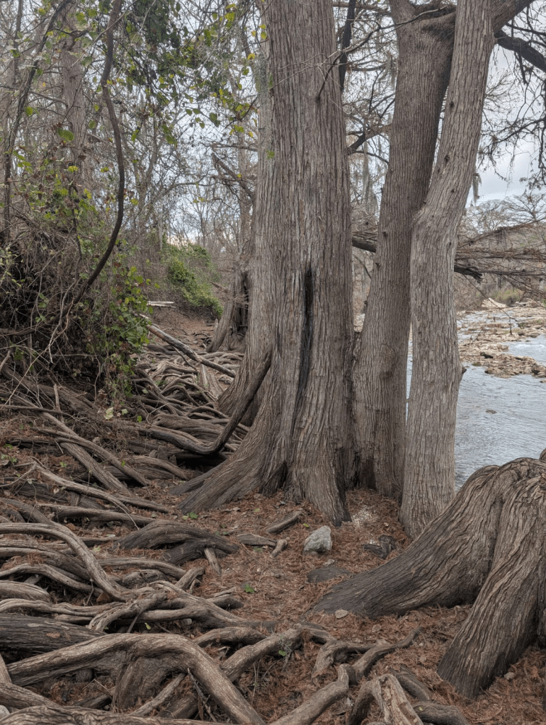
Bald Cypress Trees: Sentinels of the Guadalupe
In the end, a special mention to the riparian trees: Bald Cypresses and Pecans along the Guadalupe which are a signature of Guadalupe River. Several of the survivors were found clinging to the trees and were rescued from these trees including a woman who was washed 32 kms down the river. The tree on which she was found has also saved the life of a first responder some years back. In 1987 too, Bald Cypress Trees saved lives of a number of teenagers washed down the river. It is hard to imagine the scale of the tragedy if there were no trees but retaining walls around the river. A specific lesson for India as it clears trees along the rivers to make room for walls and embankments.
Parineeta Dandekar, SANDRP (parineeta.dandekar@gmail.com)
POST SCRIPT 1: July 15 2025: Dick Eastland—executive director of Camp Mystic—received an alert on his phone from the National Weather Service at 1:14 a.m. on July 4 about “life-threatening flash flooding.” At that point, he “began evaluating whether to evacuate the young campers who were sleeping in their cabins without access to electronics,” according to Eastland family spokesperson Jeff Carr. He started to evacuate 45 minutes later, after the flood was upon them. This representation strikes me as unfathomably strange and expressive of incompetence of a mind-boggling scale.
Everyone who has spent some time in the Texas Hill Country understands the meaning of the expression “flash flood”—that is, a creek or a river that floods in a flash, leaving humans and animals who are in the flood plain unable to escape. Dick Eastland had been at Camp Mystic since 1974 and was certainly aware that the camp and other habitations along the Guadalupe River had been been subjected to flash floods in the past that had swept away and drowned people. In July 1987, ten children at a church camp in Comfort, Texas— about thirty-nine miles downstream from Mystic—were drowned by a flash flood. (https://www.thefocalpoints.com/p/a-competence-deficit)
REFERENCES:
[1] http://www.texastribune.org/2025/07/08/texas-weather-service-warning-kerr-county/
[i] https://www.nytimes.com/2025/07/05/us/texas-hill-country-guadalupe-river.html
[ii] https://www.gbra.org/wp-content/uploads/2021/04/StayingSafe.pdf
[iii] https://www.gbra.org/wp-content/uploads/2021/04/StayingSafe.pdf
[iv] https://www.houstonchronicle.com/projects/2025/texas-camp-mystic-guadalupe-fema-floodplains/
[v] https://www.facebook.com/jimspencerKXAN/posts/pfbid0pt9knKpctDiDrdAVWujk1i8nLsL99YVpAV4RX8d9AiZ4AvJnU54hgLHaAyX26Lobl
[vi] https://www.nytimes.com/2025/07/08/us/abbott-blame-floods-losers-football.html
[vii] https://www.usatoday.com/story/news/nation/2025/07/08/texas-floods-search-rescue-live-updates/84502052007/
[viii] https://www.facebook.com/jimspencerKXAN/posts/pfbid0pt9knKpctDiDrdAVWujk1i8nLsL99YVpAV4RX8d9AiZ4AvJnU54hgLHaAyX26Lobl
[ix] https://www.reuters.com/sustainability/climate-energy/dozens-missing-after-floods-nepal-china-border-2025-07-08/
[xi] https://www.gbra.org/wp-content/uploads/2021/04/StayingSafe.pdf
[xii] https://www.texastribune.org/2025/07/05/texas-hill-country-floods-warning-forecast-nws/
[xiii] https://www.cbsnews.com/news/texas-flooding-guadalupe-river-how-much-rain-fell-national-weather-service/
[xiv] https://www.researchgate.net/figure/Location-of-the-Guadalupe-River-Basin-including-the-upper-Guadalupe-River-watershed_fig1_271518668
[xv] https://www.kctv5.com/video/2025/07/07/guadalupe-river-rises-26-feet-45-minutes/
[xvi] https://www.nbcdfw.com/news/local/texas-news/national-weather-service-alert-timeline-texas-flooding/3879084/
[xvii] https://yaleclimateconnections.org/2025/07/devastating-flash-floods-slam-texas-hill-country-tropical-storm-chantal-heads-for-carolinas/
[xviii] https://slate.com/technology/2025/07/texas-flood-guadalupe-river-camp-mystic-hill-country.html#:~:text=Meteorologists%20fired%20back%2C%20with%20AccuWeather%27s,the%20risk%20of%20fatalities%20had
[xix] https://www.campmystic.com
[xx] https://www.accuweather.com/en/weather-news/camp-mystic-where-deadly-texas-flooding-took-place-is-in-flash-flood-alley/1791962
[xxi] https://www.nytimes.com/interactive/2025/07/05/us/camp-mystic-texas-flooding.html
[xxii] https://www.accuweather.com/en/weather-news/camp-mystic-where-deadly-texas-flooding-took-place-is-in-flash-flood-alley/1791962
[xxiii] Officials Feared Flood Risk to Youth Camps but Rejected Warning System – The New York Times, https://www.nytimes.com/2025/07/06/us/texas-flood-warnings-sirens.
[xxiv] https://www.facebook.com/jimspencerKXAN/posts/pfbid02afPvNZAUQP8XdVsZcWzv1e9fDt3JSTYY1CzYAb1xLEMkhbikCZpXHb3x23AMyL9sl
[xxv] https://www.pbs.org/newshour/nation/as-noaa-braces-for-more-cuts-scientists-say-public-safety-is-at-risk
[xxvi] https://statescoop.com/fema-noaa-cuts-emergency-response/
[xxvii] https://www.nytimes.com/2025/07/06/us/texas-flood-warnings-sirens.html
[xxviii][xxviii] https://www.nytimes.com/2025/07/06/us/texas-flood-warnings-sirens.html
