I was standing in a waste dump, with pigs, garbage and dumped clothes all around me when Mr. Shailendra Patel told me to take off my shoes.
Just a few steps ahead of me was a miracle.
In the midst of the dump, Mr. Patel went down to a sparkling spring of clear water and kneeled down. This was a living stream in the heart of Pune city, with “development” all around, with a sewage carrying nallah flowing right next to it. Crystal clear water gushed out of rock crevices, there was a small sandy pool with tiny fish, water skaters and a desolate looking statue of a jaldevata on a stone ledge.
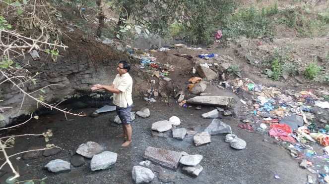
Mr. Patel talked with ladies with their washing loads who came to the spring, with school children running past, late for the school, with construction workers brushing their teeth nonchalantly next to the spring. The problem was he could not talk with the people who stayed in huge apartment complexes right next to the spring. They find the place too filthy, despite the fact that the tankers that supply water to complexes fill up from springs like these.
One more problem was that the Pune city does not recognise existence of such springs and the City Development Plan has not marked this as a spring or stream. It is up for grabs. A building complex will be built over this at any time.
This led me thinking, how does a city recognise & protect living streams and springs? How can we make the city development plan leave them out of development activities? Are there examples where this happened somewhere?
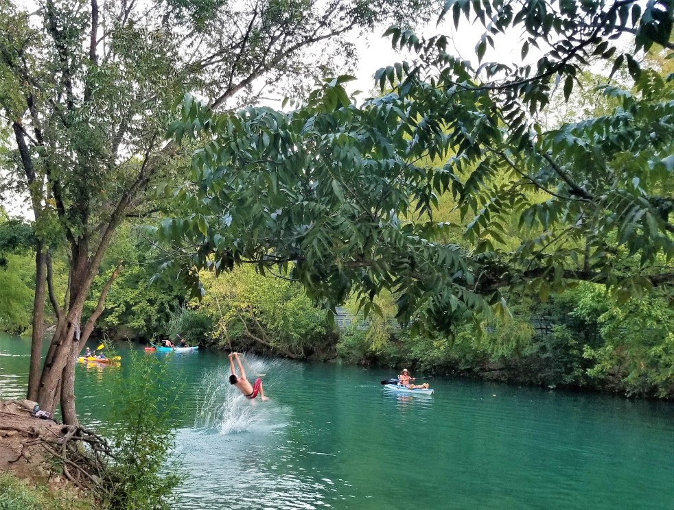
Back in Austin, Texas (USA), I met with Ms. Ana Gonzalez, Environmental Scientist and Riparian Specialist leading stream restoration work in the Austin Watershed Protection Department[i]. Ms. Gonzalez graciously agreed to discuss intricacies of stream protection and restoration in Austin, Capital of Texas and the journey which went from channelizing streams, to now protecting riparian areas, recharge zones and dechannelizing sections of streams, known as “Creeks” in Austin. Austin (elevation 149 m) is a City of creeks, with hundreds of small and large creek running throughout, making up more than 1000 miles[ii].
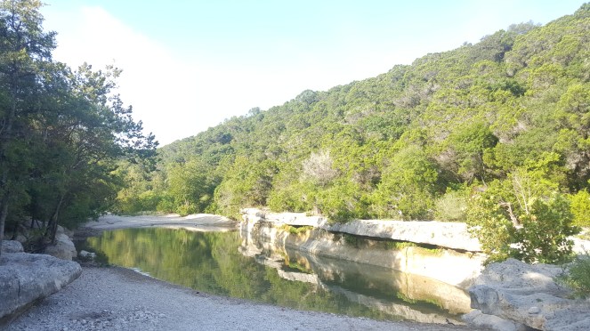
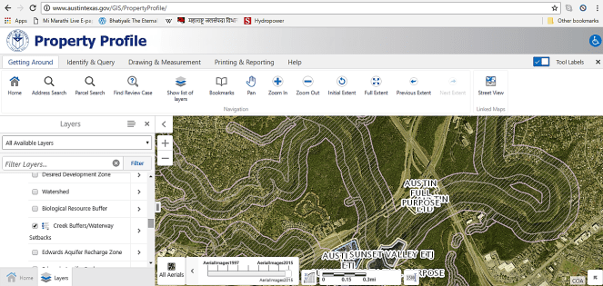
Watershed Protection Department has an intricate map of creeks in Austin which it happily distributes for free for those interested. Most creeks[iii] are mapped, marked and zoned with development zoning. Of course, things are still work in progress, but there are several aspects to learn from.
A brief snapshot of the interview of Ms. Ana Gonzalez.

What are the various development and restoration zones which protect creeks in Austin?
A: Almost all creeks are mapped with zones. There are several layers of zoning. First is the Floodplain zone along a creek. Floodplain zoning is extremely important not only from the ecological perspective, but also from the perspective of safety of the citizens living in floodplains. Austin is in the “Hill Country” of Texas, also known as the Flashflood Alley. Erratic and intense rainfall, clay soils and Karst landscape, made of limestone means that most water that falls quickly enters creeks and rivers. We recently had once in 100-year floods for three consecutive years. That’s the expectation, with climate change models predicting more frequent, bigger pulses. In this scenario, floodplain management is very important. We do not allow any construction in 25-year floodplain and its highly regulated in once in 100-year floodplain. Few things that are allowed are Golf course (not that I like it), athletic fields, creek crossings with design bylines, bike and pedestrian trails etc. But if you in anyway change the boundary of this floodplain, that triggers a Code Piece with certain strong conditions[iv].
But this was not always the case, we have a legacy of houses within the floodplain and people are in the harms way. For severely risky areas, we have a buy-out program to purchase parcels so people can move to safer areas. This is super-expensive, but a long-term approach. Then on we do not allow any more development in this zone.
This is a difficult debate but depends on your priorities. In situation like India that you explain, an approach might be to protect undeveloped patches along creeks and rivers immediately and over time, try to have a fund to move people out of floodplain and reconnect green space at least in 25-yr flood plain and restore it. It’s the risk of having people there. From safety perspective we need to move people in a socially equitable way, not kicking them out of the way.
How do you demarcate floodplains?
A team of engineers model each creek in the city. They simulate the rainfall, topography and shape of the channel so when we have a rainfall event, we know how far water will go. Flood plains are different for different creeks. Two important considerations are slope of watershed and how big the drainage area is. More upstream is a smaller floodplain, downstream is wider floodplain. Each floodplain has its own boundary. While modelling, we consider a fully developed region, because we then don’t have to change it with development.

We have another buffer zone known as Critical Water Quality Zone/ Creek Buffers which is the area to be left natural and undisturbed as a riparian area. Some of the services this buffer provides are Healthy vegetation, erosion prevention by holding on to the banks, filtering pollutants, provides habitats, shades the creek for cooler and clear water, etc. By promoting healthy soils and vegetation along the creek corridor and allowing the stream adequate space to migrate over time, stream buffers help control flood impacts, reduce channel erosion and property loss, help maintain good water quality, reduce operation and maintenance costs, and provide multiple community benefits.[v]
How are these Buffers protected? Is this area smaller than the flood plain?
Bigger the creek, larger the Buffer zone. Sometimes, Buffer is larger than floodplain. In headwaters the critical water quality buffer is larger than floodplain, it can reduce in the downstream. Width of the buffer depends on the size of the drainages. For the main channel of Barton Creek, the width of the Critical Water Quality Zone is 400 feet from each side of the stream centerline.
While the Buffer can be a part of your property, there can be no construction in this zone. Buffer is not actively monitored but there are restoration projects going on in many of the buffers, where we monitor how we see how these areas are gaining function. We have a project called Riparian Functional Assessment[vi], comparing sites where canopy has been untouched for 50-60 years, we measure several characters in those areas and we hope in the long term all our creeks can be restored like natural areas.
So do you see a difference between urban forested streams and degraded streams?
Absolutely! Soils are the basis of what happens in riparian areas. We need fluffy, loose soil so that when it rains, water can infiltrate and then it is slowly released in the creek, reducing flooding, keeping the creek ever-flowing and providing services. This is how riparian areas are sponges. Riparian soils in degraded areas tend to be much more compacted, with less organic matter, and roots of the plants don’t go very deep. Mature riparian trees intercept rain, which moves down along their trunks and meets the soil slightly away from the creek. These trees are special conduits. This reduces impact of flashy rainfall events, directly reducing floods and erosion. In restored areas, you have mature canopy, middle trees and baby trees and the area has a living future. Even dead wood is an important feature, providing habitat for fish, nutrients, slowing down speed of water and increasing floodplain complexity. It is so important in restoration that sometimes we bring logs to restoration sites!
Soils in riparian areas hold exponentially higher amounts of carbon and each percent increase in soil carbon increases its water holding capacity by 20,000 gallons! In addition, this carbon is also taken out of the atmosphere, that is sequestered.
In India many streams/creeks are being channelized ostensibly for beautification or reclamation of land from the flood plain or to protect people from flooding. This leads to loss of riparian areas also. Do you think channelization is a solution to tackling floods?
Not at all. Channelisation destroys floodplains and riparian areas. When you channelize a stream, you lose all that a floodplain provides, in addition, you have to maintain a channel till perpetuity. Streams don’t like to be trapezoidal, straight channels. They are dynamic systems, they are going to break the channel. It is a harmful solution environmentally, but if run by governments, its also a very expensive solution in the long term. This is as sensitive discussion, I’m aware of that, but if you look long term, channelizing a stream is not a sustainable solution, even to keep people out of harms way. Entire society loses all the services provided by the riparian corridors and that’s really sad.
In addition, with increasing extreme rainfall events, engineers cannot always model channels properly since past is no longer the best guide for future. Floodplains and riparian areas are our real insurance against floods.
In Austin, we do not channel our streams anymore. We’ve done it in the past to protect people from flooding, but now we are looking at other options, including buffers, floodplains, bypass channels, tunnels, storm water retention areas, retention ponds, and lastly buy-outs. There is still so much that needs to be done here. But all these options need to explored before even considering channelizing a stream.
How is floodplain buy-out program funded?
We have seeding funds from tax revenue, some comes from Federal Government, in the form of FEMA (Federal Emergency Management Agency) funds. Our department has allocated some funds, which come from drainage utility charges. We cannot buy out everyone, about 10% Austin lies in a floodplain. But in some floodplains, where we see clearly that engineering and restoration solutions will not work, we have to impose buy outs as the best cost and most sustainable approach. It’s a sensitive discussion and social equity is very important. In India, I’m sure it’s more complex.
Apart from Floodplains and Buffer zones, are there any other development restrictions to protect creeks?
We have mapped “Critical Environment Features” likes wetlands, springs. Not all mapped completely, but when development projects apply for permitting, we study area and it gets mapped, if not already mapped. All critical environmental features are protected and any development project has to demonstrate “No harm done”.
Other Critical Environment Features include Recharge zones, caves, fractures, sinkholes, rocky bluffs: rock walls in the stream which are important from erosion perspective etc.
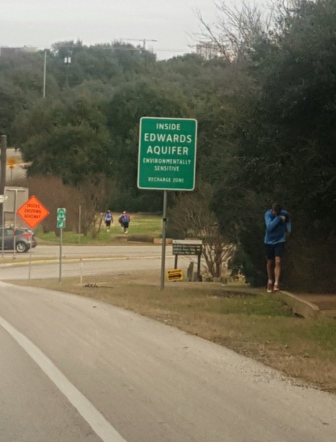
Is there anything specific for groundwater?
Entire south of Texas is fed by an aquifer known as Edwards Aquifer. The aquifer has its own Authority with its set or rules, in addition to rules of Texas Commission on Environmental Quality and individual cities. Edward Aquifer Recharge Zone is extremely sensitive. We have mapped the whole aquifer, contributing, recharge and discharge zones of Edward Aquifer with a team of geologists. In contributing and recharge zones, Development Rule are most difficult and stringent. Impervious limits are different, water quality treatment ponds need to be lined and this is very strict as compared to other layers. Any development needs to file a water pollution abatement plan with the Texas Commission of Environmental Quality (TCEQ) and organized sewage collection system plan for the site.[vii]
How do you go about restoring a stream? Do you have set guidelines for this?
We have two major programs: Erosion control and stream restoration. The direction of stream restoration program that we took now, supporting natural riparian areas, grow zones, native vegetation etc., evolved in an interesting way.
A few years back, we realized we have all the creeks that are mowed, devoid of vegetation, with possibly just short grass. Some creeks needed it to maximise conveyance. But we were thinking, why don’t we stop doing this and try and return them to natural state. Eventually this idea caught on.
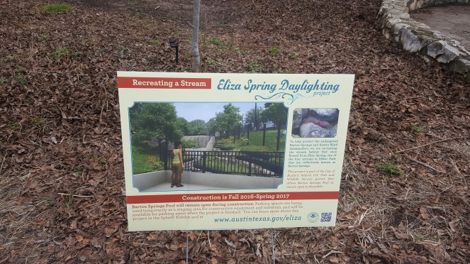
It all started with a creek called Willow brook, in a very urban area. The banks of this creek were in a precarious condition due to erosion and it needed an erosion stabilization program. The program took a long time to materialize and in the intervening 12 years, the creek was not mowed, native plants kept growing on its banks and it returned to a natural character. Finally, the project was on, and this time the neighbourhood was up in arms against it! They did not want their trees to be cut! No tractors were allowed at the site!
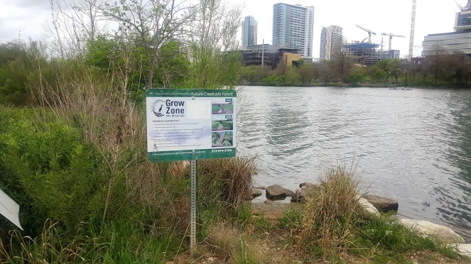
We jumped at this opportunity and did full restoration, planting, seeding, irrigation on the riparian area, it was great, but this was a lot of work! We have 1000 miles of creeks in Austin. We can’t do it for all. It’s too resource intensive. So we called Parks Department to develop “No Mow” zones along creeks, we provided native riparian seedlings and baby trees, but no irrigation. Somewhere we decided No Mow was negative and started calling them “Grow zones”.
So now we have several Grow zones, coordinating with volunteers, coordinating with neighborhood organizations.
But this is not our story. We could not have done this alone. We have partnered with an amazing community organization “Keep Austin Beautiful” who runs a program called Adopt a Creek[viii]. We realized we can use this model. We provide resources and technical assistance. They are the face, we are at the background and it works just perfectly.
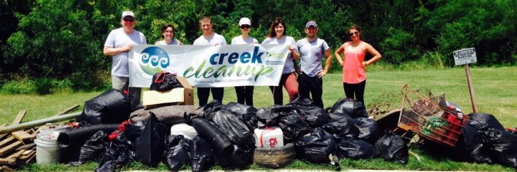
Today, more than 100 creek sections in Austin are adopted, with their own restoration plan and trash clean up drive.
One more organization we partner with in planting baby trees in riparian areas is called “Tree Folks”. [ix] They coordinate volunteers and organize riparian plantation drives. 100s of volunteers take part in this each month.

Having the community to work along with us and partnering with these two organizations is a hard-learned lesson. We realize how sustainable and energetic this is. With 1000s of miles of creeks, there was no way we could have done it. This way, people are connected with their own creeks and it’s much more long-lasting and organic.”
Ms. Gonzalez showed me several examples of stream restoration where the buffer was protected, engineering plans were changed to more natural ways of protecting creeks, banks were dechannelized and planted with native vegetation to arrest erosion.
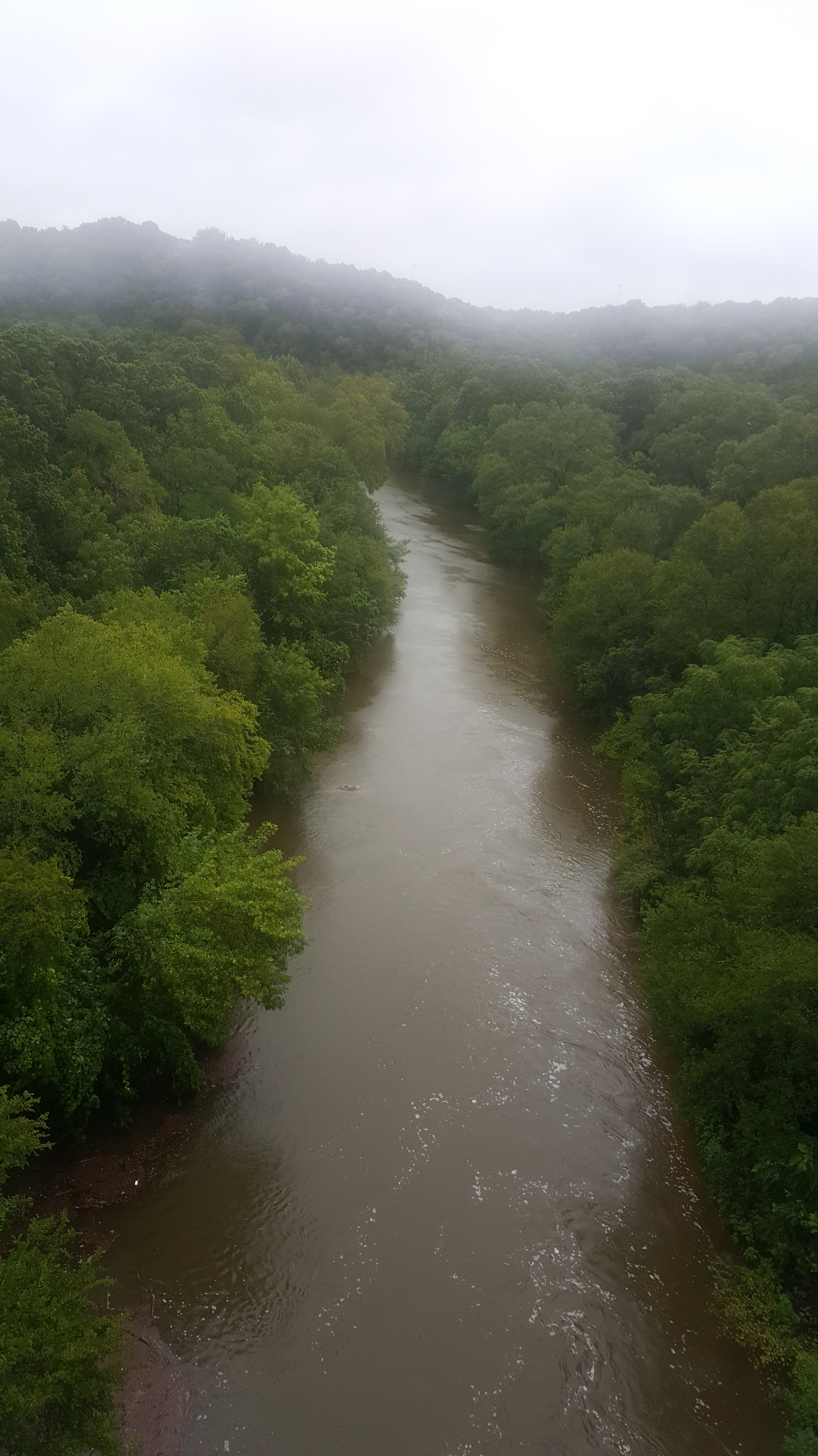
We looked at pictures of Willow brook restoration from a degraded, desolate looking stream to a verdant, hidden and forested stream in about 6 years, Ms. Gonzalez stopped at the picture. “This picture is so beautiful. Willow brook makes me cry.”
I looked at several more examples in silence.
~~
There is sheer magic in people coming together for their streams. People from Government, civil society, students, housewives. People coming together for a stream, backed by a positive and participatory governance can make all the difference.
We need a radical shift in the way we are managing urban streams in India. It looks like the key lies in democratizing governance of water, rivers and streams and looking at local population and organizations as an ally in the process, not an obstacle. People like Mr. Shailendra Patel in Pune are comrades-in –arms of the government in the journey towards protecting streams and rivers and we all need to be a part of this change.
Parineeta Dandekar (parineeta.dandekar@gmail.com)
END NOTES:
[i] http://www.austintexas.gov/department/erosion-control-and-stream-restoration
[ii] http://www.austintexas.gov/blog/city-creeks-explore-creek-every-council-district
[iii] http://www.austintexas.gov/floodpro/
[iv] More about permissions here: http://www.austintexas.gov/page/floodplain-development-information
[v] See this video for more info: https://youtu.be/orNG8KD3LPw?list=PLDKZTUlNzz3oErOxiufs8duewSNmQFQ_j
[vi] http://www.austintexas.gov/sites/default/files/files/Watershed/riparian/SR-12-12-Riparian-Functional-Assessment.pdf
[vii] More information here: https://www.tceq.texas.gov/assets/public/comm_exec/pubs/rg/rg-011.pdf, https://www.tceq.texas.gov/permitting/eapp
[viii] https://keepaustinbeautiful.org/programs/adopt-a-creek/
[ix] https://www.treefolks.org/

EXCELLENT AND INSPIRING. HOPE OUR CHENNAI, MUMBAI AND OTHER METROS READ THIS AND INITIATE LOCAL ACTION.
LikeLike
Thanks a lot, Sr. Plz help us spread the word about this article by sharing it.
LikeLike
I sent the following mail to CJ of Hyderabad High Court:
Dear Hon’ble Chief Justice,
Sir, this is with reference a news report on 2nd February 2018 as referred above on the subject referred above. In this connection, I would like to bring to your kind notice the following few facts.
1. Supreme Court Judgment dated 1st December 2000 of above subject, wherein the Hon’ble Court upheld the GO111 under environmental Act and introduced Precautionary Principle as these two lakes are drinking water resources. I was a member of APPCB Task Force [another member was Prof. M. V. Naiudu on whose name the SC order in Civil Appeal Nos. 368-371/99 stands]. As per the court’s directive, this committee closed the polluting industries in the catchment area – we both sit on the legal hearings of all types of polluting industries. I was a co-opted member of Supreme Court Monitoring Committee on Hazardous Waste.
2. Shamshabad Airport – I appealed the then Chief Minister to include new Airport in CBI Probe [see The Hindu, dated 28.9.2006] and later met CBI officials and presented necessary documents on this matter. After discussing for few hours, CBI simply said “sorry”. Then I approached the Hon’ble High Court with a PIL.
3. W.P.No. 9386/2007: I on behalf of environmental groups filed this PIL in 2007 relating GO111 violations. Government submitted the list of violations to Hon’ble Court. MAUD/Government of AP submitted a Memo No. 14046/I1/07 dated 12-10-2007. This Memo ratified the GO111. With the Hon’ble Court directive, government published the Memo in news papers and TV scrolling.
3(a) The Memo state that “Accordingly, Government hereby instruct all concerned authorities of —- which are associated with regulating the construction and development activity within the catchment area of Himayat Sagar and Osman Sagar Lakes not to allow any construction, layout and non-agriculture development activity within the upstream area of Himayat Sagar and Osman Sagar Lakes in tune with G.OMS.No. 111 M.A. dated 8-3-1996 – downstream issue was dealt under another PIL and government provided guidelines on this.
The Memo state that “Now that this entire catchment of the two water bodies falls within the jurisdiction of recently expanded Hyderabad Urban Development Authority area, the Vice Chairman, Hyderabad Urban Development Authority, the Collector, Ranga Reddy District, and the Collector, Mahaboobnagar District shall ensure that no construction or development comes in violation of the above said G.O. They shall keep a strict vigil and take stringent action against the violators as per the law”. But the reality is that they have been simply enjoying watching while the violations taking place rampantly even after media reporting in some cases.
3(b) Also, government agreed to establish “Lake Protection Authority” but failed to do so. In its place established a toothless body “Lake Protection Committee” – G.O. Ms No. 157 dated 06-04-2010 – wherein it refers that “in compliance of the orders of Hon’ble High Court in W.P.No.9386/2007, dated 02-02-2010, have decided to constitute a Lake Protection Committee for preservation and protection Lakes in Hyderabad Metropolitan Development Authority area pending consideration of enactment of separate legislation for constitution of Lake Protection Authority. While Justice Ramana, who was an acting Chief Justice, while dealing the case asked the government council, whether the government will appoints the committee members, if not court will appoint them. By next hearing Justice Ramana moved to Supreme Court.
3(c) during the hearings, government approached the Hon’ble Court to modify GO111 with reference to Wattinagulapalle. Court expressed anger on this and then government withdrew the request to modify GO111.
3(d) vested groups tried to get amended GO111 for this got a report from EPTRI [NGRI & IICT]. On this I submitted my counter to Chief Minister. After seeing my counter he dumped the report. In this connection the Chief Minister come forward to help farmers in terms of subsidized support. Also, he proposed Chevella-Pranahita Godavari River project to get water for irrigation. The present CM has a technology to earn one crore per acre. With the government support they can implement the same technology and reap the riches. Instead protecting the lakes that supply drinking water at no cost through gravity, it became proverb “we have plenty of water from Godavari and Krishna” who needs this water. We get Godavari and Krishna water at huge costs and on the way farmers lose their lands for laying pipes; they lose their share of water. This needs power to pump water. The cost of getting water is high. Also, 55% of water under metro water is going as waste [pilferage & losses] and 75% of the water is going as wastewater which can be treated [STPs] and used for non-drinking purposes – irrigation, construction, green belt development. Governments are not interested on these as they don’t get much profit.
4. Adapting the lakes by Cyberabad Police Commisionarate: I questioned the veracity of such move through a letter to Police Commissioner. Police Commissioner discussed the entire issue with me and called for a stake holders meet. In this meeting I reiterated what I told to Police Commissioner earlier. In this meeting they withdrew from the adaptation of lakes. This would have created large scale illegal/anti-social activities that help illegally established resorts in the lakes catchment area.
The Court Registry should have brought these issues to bench knowledge before taking any decision on this issue. In fact in the case of Durgam Cheruvu on our petition the court directed the government to demolish illegal constructions within the buffer zone & full Tank level. Nothing has happened on this but government has undertaken commercial activity. Again somebody approached the court. The court has given again the same judgment. Court time is wasted this way..
With Kind Regards
Dr. S. Jeevananda Reddy
LikeLike