
Arunachal Tawang residents protest against unfulfilled promises Hundreds of residents on July 22 marched through the streets of Tawang, the home district of newly elected CM Pema Khandu, in protest against non-fulfillment of their demand for jobs to kith and kins of two anti-dam activists killed in police firing on May 2. During the protest march they also led a signature campaign against large dams planned in Tawang, where the predominantly Buddhist Monpa tribe feared that many of the proposed hydro-power projects would damage sacred Buddhist sites in the district. At least 13 large hydro-power projects have been planned in the district, which shares border with China’s Tibet region. On June 21 the Lamas-led Save Mon Region Federation had issued six-point charter of demand to the state government for fulfillment in 30 days. Arunachal comprises a fragile, rich parcel of wildlife and ecosystem, among the richest ecosystems in India. But planning & building of hydro projects has been and will cause irreversible environmental damage. Perhaps it’s time for an aggressive freeze on all the un-built projects and an evaluation of other models of energy. Mr Prema Khandu must consider why Arunachal should become India’s mitochondria-the country’s energy provider, while losing its own enormous wealth. But contrary to this new while addressing a press conference, the new CM, on July 18 said that the govt would find ways to tap the petroleum resources & harness the hydropower potential which could be a money spinner for the state. On the 2000Mw Lower Subanisiri HEP at Gerukamukh, Mr Khandu has emphatically said he would discuss the issue with the Assam govt as well as the Centre for a solution. He said that in all the hydropower projects the affected people should be taken into confidence by both the executing agencies as well as the state govt. The new CM elected from Tawang, seeing the hydropower projects as money spinner does not sound very encouraging. Let us see how far he actually goes to take people into confidence as promised by him.
Continue reading “DRP: 25 July 2016 (Tawang residents protest against unfulfilled promises)”Tag: Bihar

DRP: 18 July 2016 (Remove inefficient Farakka Barrage: Bihar CM)
Bihar CM demands removal of Farakka barrage CM Nitish Kumar on July 16 demanded removal of Farakka barrage on river Ganga, saying “the disadvantages of the barrage appear to be higher than its benefits”. Raising the issue of Bihar’s share in Ganges waters at the 11th Inter State Council meeting in New Delhi, Nitish also sought the Centre’s intervention to ensure uninterrupted flow of water from the states of upper co-basin so that the entire length of Ganga has continuous supply of water even during lean season. The meeting was chaired by PM Narendra Modi and attended by CMs of different states and union ministers. The CM also told the meeting that responsibility to ensure the required water availability at Farakka barrage has been put solely on Bihar. Presenting Bihar’s views Nitish further added that about 16% of the catchment area of river Ganga is in Bihar, but in the lean season 3/4th of the total water flowing in Ganga comes from rivers of Bihar. Estimated 400 cusecs of water flow is received at the Uttar Pradesh border of Bihar in river Ganga. However, at Farakka barrage, 1500 cusecs of water flow is to be ensured, which is achieved mainly through the water contributed by the rivers of Bihar. Indeed, during lean season, not even 400 cusecs of water flow is available at the border of Bihar. In this regard, Centre’s intervention is required to ensure uninterrupted flow of water from the states of upper co-basin, so that the entire length of Ganga river in Bihar has continuous supply of water even during lean season. Nitish also demanded formulation of an effective National Silt Management Policy, saying such a body at the national level is essential for silt management as well as for ensuring uninterrupted flow of water not only in Ganga, but all the other rivers.
Continue reading “DRP: 18 July 2016 (Remove inefficient Farakka Barrage: Bihar CM)”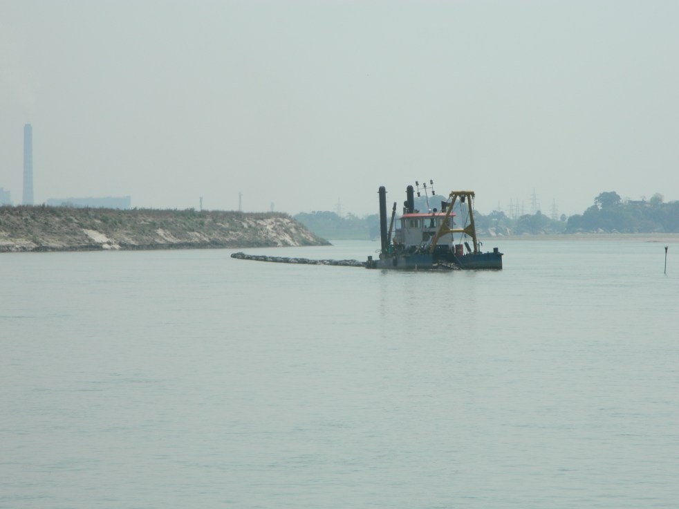
In the Pits: the Ganga River, dredged to death
Guest Blog by Nachiket Kelkar (rainmaker.nsk@gmail.com)
When human beings fall into manholes or die in traffic accidents on a highway they are all over the news. We pity and fear such news, and feel sad for the deceased, just because the whole event is so unfortunate. We are angered by the condition of traffic – that continues to remain appalling despite having six-lane highways that look deceptively magnificent. We wonder if these cases could have been avoided. It is therefore even more disturbing that not a single news item has covered a series of major accidents that have happened right in the middle of the Ganga River National ‘Waterway’ (India’s National Waterway No. 1; see Dams, Rivers & People: Feb-March 2016 issue: p. 1-7, 2016 for details[i]) in the last six months.
Over twenty people have died by drowning at the Barari Ghat (Image 1) at Bhagalpur in Bihar in this period. Offering prayers, taking dips, or lunging in for a calm swim, these people have slipped away as their feet have lost the ground all of a sudden. The river, scouring off the silt from under the concrete, has been catapulting their bodies into the deepening abyss on the fringes of the ghats. Many bodies have not even been found. Family members of many, whose bodies were found, must have never suspected that they would have to carry back their kin’s corpses. What made the same Barari Ghat, which people traditionally visited for years, so dangerous suddenly?
Continue reading “In the Pits: the Ganga River, dredged to death”
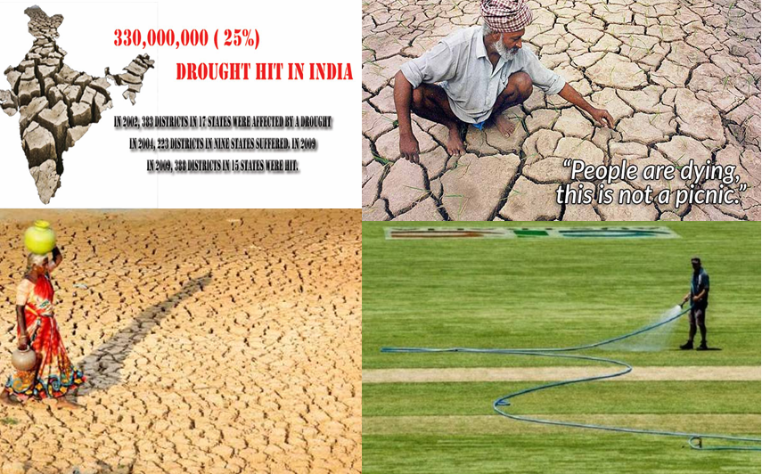
Landmark Supreme Court Order on Govt Failure in Tackling Drought
A PIL under Article 32 was filed by the NGO, Swaraj Abhiyan praying for directions for declaration of drought and relief in affected areas. The apex court came out with a 3 part judgment earlier this month – the first one dealt with the issue of drought and the latter judgments took up the poor implementation of the National Food Security Act, 200513 (NFSA) and the Mahatma Gandhi National Rural Employment Guarantee Act, 2005 (NREGA). These directions largely signify the failure of the governance in tackling drought and suggest actions to be taken hence, we need to be thankful to the petitioners and apex court for this. We also hope the apex court continues to monitor the implementation of the directions.
Continue reading “Landmark Supreme Court Order on Govt Failure in Tackling Drought”

Bihar Floods of 1987- V – District Khagaria
Above: Cover photo and map from NIDM report of Bihar floods 2007
Guest Blog by: Dr. Dinesh Kumar Mishra
Khagaria faced the first round of floods starting 8th July this year when the floodwaters of the Kosi, the Kareh and the Bagmati had engulfed large number of villages in the district. The Ganga and the Burhi Gandak was relatively quiet at this time despite heavy rainfall locally. It took towards the end of July that the flood level of the rivers started rising alarmingly and the Kazijaan embankment on the Burhi Gandak breached on the 2nd August in Alauli block of the district. The flood water emanating out of the gap created thus engulfed the Panchayats of Raun, Sahasi, Budhaura, Mujauna, Bhikhari Ghat, Shumbha and Burhawa Haripur. The road connecting Alauli to Khagaria was submerged in flood water and its connection with Khagaria was snapped. There was an untimely flood in the Kosi and all the Panchayats of the Beldaur block came under a sheet of water. The blocks of Chautham, Parbatta and Gogri were still spared by floods as the Ganga was maintaining its low profile. So far only 14 Panchayats of Alauli, 5 Panchayats of Chautham, 13 Panchayats of Gogri, 11 Panchayats of Beldaur, 3 Panchayats of Khagaria and only one Panchayat of Kosi was flooded. Relief programs were started in this district on the 4th August but its coverage was meager according to the local people. Rise in the levels of the Badla-Karachin embankment on the Kareh and Badla- Nagarpara embankment on the Kosi/Bagmati was causing concern among the local people. Continue reading “Bihar Floods of 1987- V – District Khagaria”
Bihar Floods in 1987 – IV – Sitamarhi
Above: Cover photo and map from NIDM report of Bihar floods 2007
Guest Blog by Dr. Dinesh Kumar Mishra
Till the end of the third week of July, rains in Sitamarhi were normal and whatever flood that normal water could cause was there in the district. But when it stared raining in the fourth week of July then just within three days, on the 27th July, the Bagmati overtopped the Muzaffarpur-Sitamarhi Road at three places and the road communication between the two towns was snapped. The road communication, however, was quickly restored on the 31st July. On the 28th July, the Bagmati breached its right embankment near Belwa Ghat in a length of 400 meters. A flood regulator was being constructed here for the past many years to divert part of the river flow (50,000 cusecs)and make it rejoin the river downstream thus delaying this portion of the flow by 16 hours when it rejoined the mainstream. Engineers hoped that by so doing they will be able to control the floods of the river to a great extent. The under construction regulator used to get washed away every year during the rains and this was not a new thing that it was damaged this year also. Water coming out of the damaged regulator submerged the villages on the western bank of the river. The rains of the past 4-5 days were enough to flood hundreds of villages in the blocks of Bairgania, Majorganj, Shivhar, Tariyani, Piprahi, Belsand and Runni-Saidpur of Sitamarhi and Katra and Aurai of Muzaffarpur district. The river water had entered the Sub-divisional HQ of Shivhar on the right bank and on the left bank in the block HQ of Belsand and the thana there through the gaps left in the embankment for constructing sluice gates in future.. The water of the Bagmati had entered every house of Sugia, Katsari, Sugia Bazar, Shahpur, Pokharbhinda, and Bisahi etc and it was flowing one and half feet above the Sitamarhi-Muzaffarpur road near Kataunjha where the river crosses this road that was closed for the vehicular traffic. There was a simultaneous flood in the rivers of the Adhawara Group and a causeway connecting the villages Chilara and Parchhaiyan was washed away. This meant that the road connection between Sitamarhi and Sonbarsa block was also lost. The rail line between Sitamarhi and Darbhanga was overtopped at many places and the train services were suspended between the two stations. Continue reading “Bihar Floods in 1987 – IV – Sitamarhi”
Bihar Floods in 1987 – III – West Champaran
Above: Cover photo and map from NIDM report of Bihar floods 2007
Guest blog by: Dr. Dinesh Kumar Mishra
West Champaran district of Bihar is located in the Northwestern corner of the state and is surrounded by the Gandak and the Burhi Gandak along with their tributaries. Two of its blocks, Madhubani and Thakaraha, are located on the western bank of the Gandak and are adjacent to the Deoria district of Uttar Pradesh. There used to be a rail line connection between Chhitauni Ghat of Uttar Pradesh and Bagaha in Bihar. A bridge connecting these two towns was washed away during the floods in 1924 and the British Government did not restore this bridge as the train service was coming handy for the freedom fighters to travel to UP and vice versa. This bridge and the rail service were restored a few years ago. The administration of these two blocks (these are split into four now) is run from Padarauna in UP during the flood season as the blocks get thoroughly disconnected from Bihar. To prevent the westward movement of the Gandak and embankment named Pipra-Piparasi Ghat embankment (PP Embankment) was constructed in 1960s as the river has a tendency to shift towards the west and there is a constant pressure of the river on this embankment during the rainy season. At times, the safety of this embankment is threatened and there is long history of its breaches and the engineers of the Irrigation Department face a tough time maintaining the embankment. When the rail bridge was not there on the Gandak one had to go to Madhubani and Thakaraha by crossing the Ganga via Chhapra, Siwan and Gopalganj. Continue reading “Bihar Floods in 1987 – III – West Champaran”
Bihar Floods of 1987-I
Above: Cover photo and map from NIDM report on Bihar floods of 2007
GUEST BLOG BY Dr. Dinesh Kumar Mishra (dkmishra108@gmail.com)
Background Bihar faced the worst floods if its history in 1987[1], the records of which are yet to be bettered. In the preceding year of 1986 the flood was severe in many parts of Bihar but as the rainy season drew to close, the last October rains failed and a vast area of the State came under the grip of drought. Surprisingly, the districts cited for perennial floods like Saharsa, Purnea and Khagaria in the State were also hit by the drought. The year 1987, however, was worst for floods in Bihar (in addition to UP and W Bengal) while the rest of the country was facing one of the most severe droughts in the century. Many parts of the country were facing famine like situation while all the rain bearing clouds had moved toward Bihar. Traditionally, two days of continuous rains or a clear sky of the same duration during the rainy season signals floods or drought in the State and makes farmers apprehensive of the days to come. Continue reading “Bihar Floods of 1987-I”

Breach in Chamarbandha Embankment in Samastipur-1958
Above: Samastipur Floods 2013 Photo: RailIndia
Guest blog by Dr Dinesh Kumar Mishra[1] (dkmishra108@gmail.com)
Background There was an unexpectedly heavy flood during 1953 in Bihar that led the State leaders to think about the flood control measures to be taken seriously. The losses incurred in the State in floods prompted the Government of India to formulate its first Flood Policy and take preventive and corrective steps so that the flood victims are helped in whatever way possible. While the Flood Policy was given the final shape and announced in September, 1954 Bihar was already under a severe spell of floods in 1954. The 1954 flood is still counted as one of the worst floods in the history of Bihar and remembered well by the elderly generation. Following the floods of 1954 and promulgation of the National Flood Policy many embankments were constructed along the Bihar rivers and the Burhi Gandak that passes through the present districts of W & E Champaran, Muzaffarpur, Samastipur, Begusarai and Khagaria and joins the Ganga about 25 km below Khagaria town was one to be embanked in its stretch below Champaran. Continue reading “Breach in Chamarbandha Embankment in Samastipur-1958”

Thanks to Bagmati Project, They Are on Roads for Forty Years
Guest blog by Dr Dinesh Kumar Mishra[1] (dkmishra108@gmail.com)
“We went to meet the collector to ask him whether we were the citizens of this country or not? If, because of the Bagmati Project, our citizenship is terminated, he should issue orders to us to leave the country and get settled in Nepal and we will go there” says the Mukhia of Masaha Alam of a village that was in the Bairgania block of Sitamarhi district of Bihar prior to the construction of the embankments on the Bagmati in 1971-72. The village had an area of 150 acres and 420 families according to 1971 census. Only 104 families have been settled till date[2] and the remaining 316 families in the village are still awaiting rehabilitation as they were trapped within the river and its right embankment then forty years ago and are literally on roads since the river was jacketed to prevent flooding of the plains in the river basin. Continue reading “Thanks to Bagmati Project, They Are on Roads for Forty Years”
