
In a development described as unprecedented, by 1030 hours on Friday, Oct 29, 2021, the waters of Kameng River in Arunachal Pradesh in North East India suddenly became dark with large amount of silt and debris and thousands of dead fish floating on the surface. A video on twitter by 1300 hours[i] showed the dark Kameng waters. (The Feature image above is from twitter post by The Arunachal Pradesh on Oct 31, 2021)
The Arunachal Times[ii] reported on Oct 30, 2021, the first instance of fishes and aquatic lives jumping out of the river to the banks was reported at Marjangla, 45 kms from Seppa, on Thursday evening. The unusual behaviour of the fishes followed just after the river’s water turned turbid at Marjangla… “A large number of fishes was coming out to the riverbank and jumping abnormally. Such activity could be seen only during sibik (local name for flood/ mudflow) in the Kameng river,” said a local in Marjangla camp. Lot of logs, followed by huge amount of foam was seen flowing down the river. The paper also reported that in the late 1960s, a similar unusual activity of fishes and aquatic lives occurred when there was a massive flood in the Para river (a tributary of Kameng) in the upper area of the district.

As reported by Eastern Sentinel[iii] from Seppa, the headquarters of the East Kameng district on that day, according to District Fisheries Development Officer (DFDO)-East Kameng Hali Tajo, the immediate cause of death of the fish is due to large content of Total Dissolved Solids (TDS) which eventually creates low visibility to aquatic life as well as breathing issues. The DFDO also stated that, during the initial testing it was found that TDS reading was 6800 mg/liter, whereas normal TDS range should be 300 to 1200 mg/liter. However, as of now no reason has been ascertained for increase in the TDS in the river, he added. Tajo also appealed to the public to avoid consuming the dead fish as it may cause serious health issues. Local MLA Tapuk Taku has appealed to the Arunachal Pradesh state government to immediately constitute a fact finding committee of experts to find out the specific reason behind the development.
On Oct 30, Scientist Chintan Sheth wrote in Eastern Sentinel[iv], “A look at satellite images taken on 29th October by PlanetScope satellites (courtesy of Planet Labs Inc) shows the debris flow along the Warriyang Bung (as corrected by Sheth on Nov 10 article, the correct name is Wapra Bung) river, a tributary of the Kameng upstream Marjangla, Khenewa circle, East Kameng district. The flood eroded valley is visible. Upstream this tributary are many glaciers & glacial lakes. Marjangla is about 60 km downstream where the fish were observed. It’s not clear if there is still any danger present in the glaciers to cause another debris flow.”

Sheth added further useful details on blog Discovering Arunachal[v]: “By the scale of the flood it seems the greatest damage occurred in the initial 30 km of the river. A larger scale event in the future cannot be ruled out so caution is necessary. There is unlikely to be any foul play by China as this region of glaciers is completely within Arunachal Pradesh, India. It is separated from Tibet by a 6000+ meter ridge-line and the Tibet side is full of glaciers. The cause of such a flow event maybe natural, rainfall induced or temperature induced. There have not been any earthquakes in the vicinity of this area in the recent past.”

The clarification by Sheth that the suspicion of foul play by China in this case is unlikely as the editorial in Eastern Sentinel[vi] on Oct 30, 2021 pointed fingers at China remembering the similarly episode of muddy Siang river waters earlier in Dec 2017[vii] and Oct 2018[viii], among others.
On Oct 31, 2021, The Arunachal Times[ix] sharing a video of the muddy Kameng on Twitter said: “Even after three days, there is no sign of improvement in Kameng River. Water continues to be muddied, flowing in huge quantities of fresh logs while fishes and aquatic lives washed to the bank. State govt constitutes fact finding committee.”
UPDATE: 1st November 2021
From Chintan Sheth: Avalanche started on 28th October 2021 as observed by Landsat 7 satellite. In an image shown below and right, taken on 28th October Landsat 7 shows the avalanche below the main glacier (glacier id G092671E27916N as per GLIMS dataset) feeding the Warriyang Bung river. Most likely its signs of the avalanche. Green colours in both images indicates vegetation.

Images taken on 14th October and 1st October of the glacier are mostly cloud-free and do not show any excessive surge or avalanche activity. The avalanche must have occurred before and/or during the period from 28th to 29th October based on the 28th Landsat 7 image above. The river is still muddy as per local authorities and may indicates the avalanche is still ongoing. As per satellite images from August 2020 and October 2021 there seems to be no glacial lake on the slopes of this particular glacier – its too steep as its the south wall of Nyegi Kangstang (6970 m). An avalanche of rock, ice, mud and snow seems to be the likely event that led to a debris flow.

Glaciers are composed of ice, rock, water and mud and move slowly. Sometimes they may move suddenly during thaw or due to a destabilizing trigger these can result in avalanches and debris flows.
UPDATE: 2nd November 2021
From Chintan Sheth: Satellite images taken by Planet Labs Inc. show completely snow and ice free slopes of Nyegi Kangstang (6970m). Nyegi Kangstang is one of the major peaks along with Chomo along the ridgeline separating Arunachal and Tibet. While it seems like the glacier is much lower down the slope of Nyegi Kangstang, the higher elevations perhaps are composed of just rock, ice and snow.
Generally the slopes look partly snow free from November – January each year but this year seems more snow and ice free than usual. Coupled with the evidence of an avalanche below the glacier and a debris flow on 28th and 29th October, the probable cause of the muddy Kameng is the collapse the southern slope sometime between 28th and 31s Oct. If this is true and there is debris that has collapsed from this mountain slope then there may still be ample debris in the valley causing Kameng to be muddy. Radar satellite images could have revealed if a lake had formed but the images are not clear enough to make a good inference. Its hard to say how much landslide and debris flow risk remains to downstream communities.


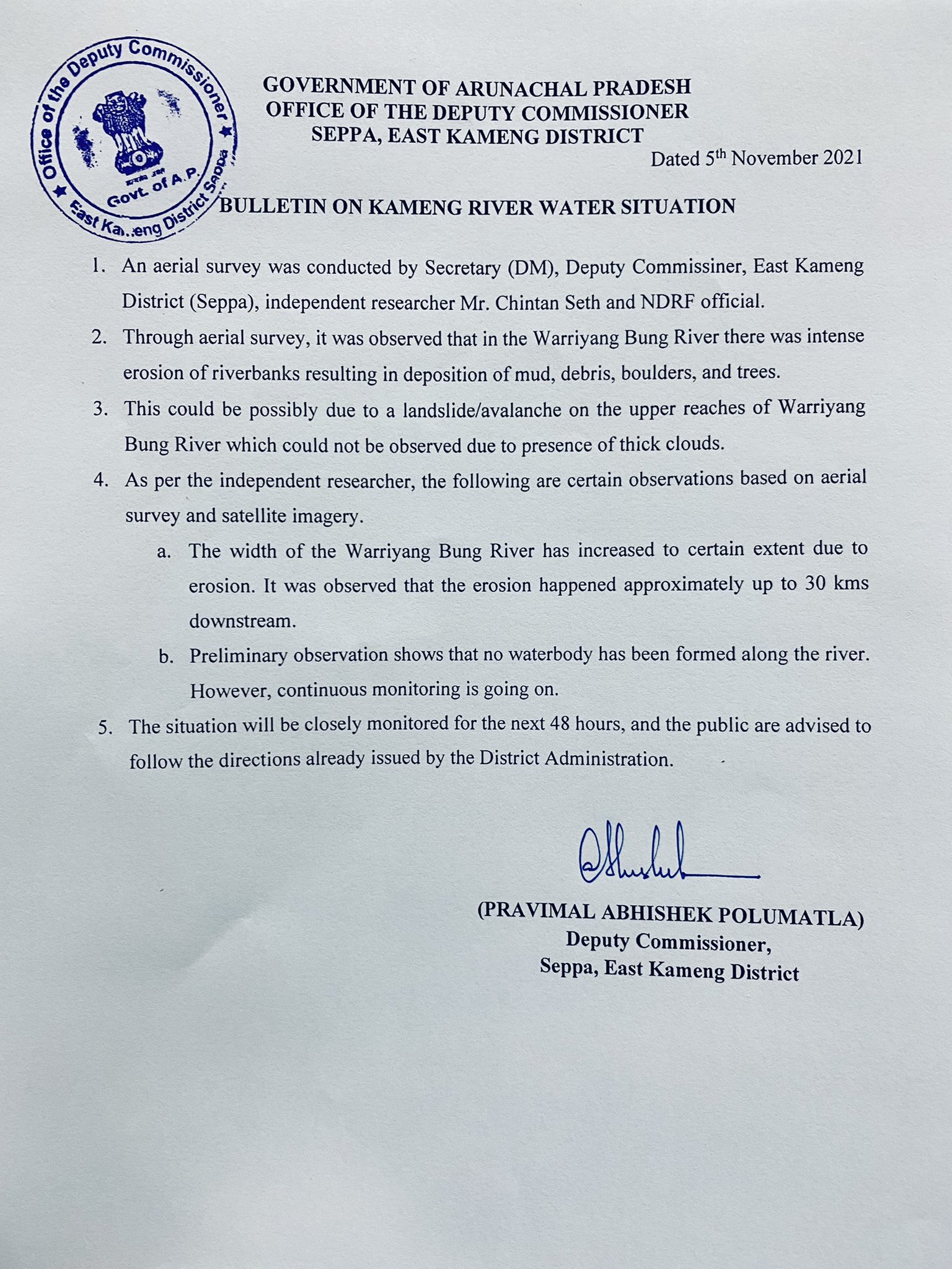
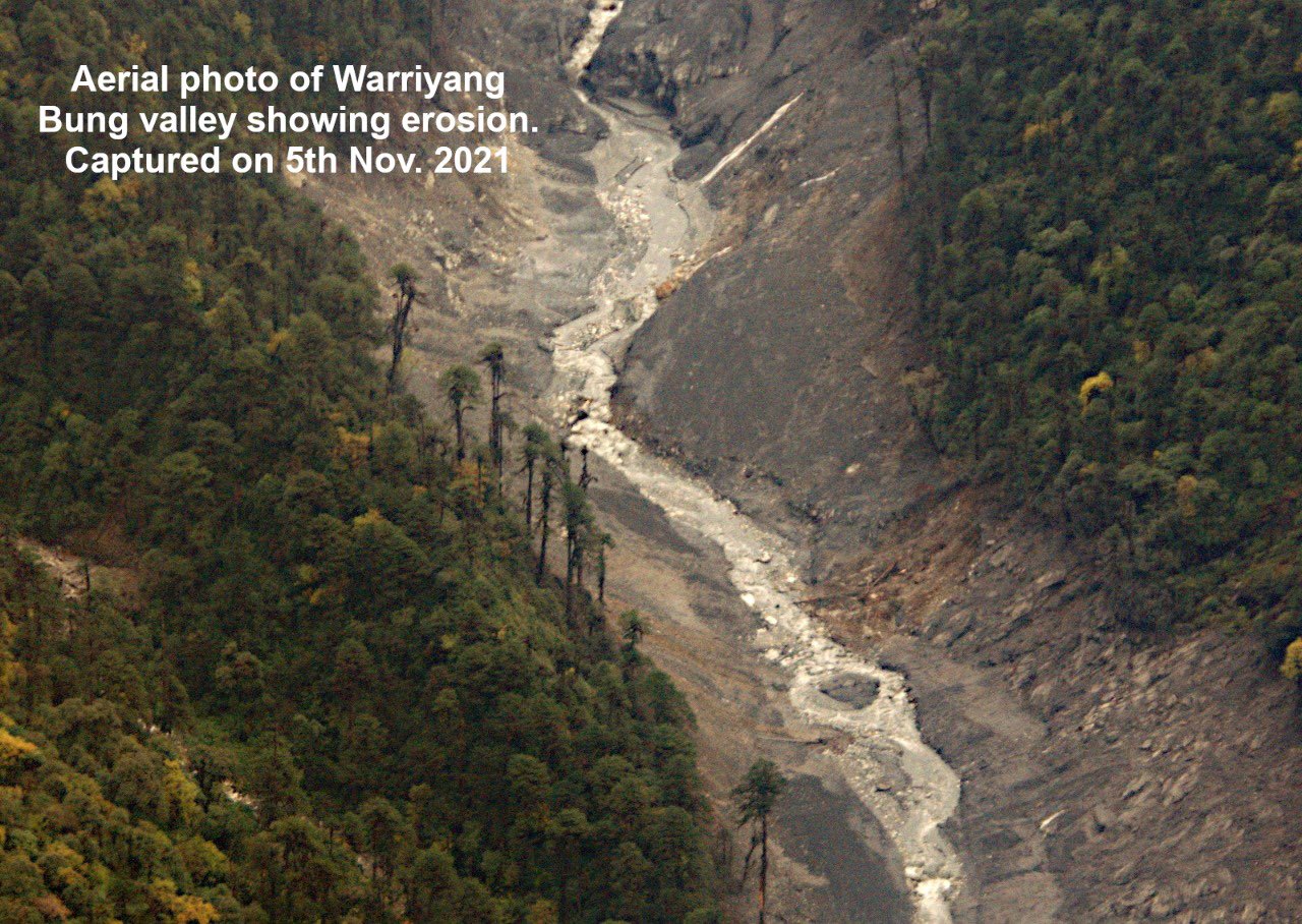
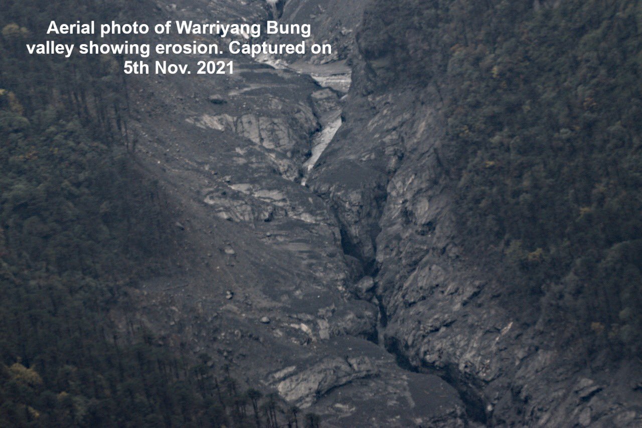
UPDATE: November 5, 2021
From DC, EAST KAMENG DISTRICT:

UPDATE: Nov 10, 2021. Article by Chintan Sheth: https://arunachaltimes.in/index.php/2021/11/10/siltation-of-the-kameng-river-is-due-to-a-landslide-upstream-of-its-tributary/. Key Aspects:
1. On 13 October, 2021, the earth sciences ministry’s National Centre for Seismology detected a shallow earthquake of 3.4 magnitude near a ridge separating the Kameng river and the Wapra Bung river. Subsequently, on the 30th, another earthquake of magnitude 3.4 occurred 46 kms southwest of this area. Satellite images of this area before and after 13 October did not reveal any detectable change in the geomorphology here. No landslides were observed. However, by the 29th, the river was already heavy with sediments.
2. On 28 October, a landslide scar was observed in the Wapra Bung river valley, and on the 29th people started observing dead fish, an exceptionally muddy Kameng river and logs deposited by the river’s banks. Satellite images show that the Wapra Bung had significantly widened due to a debris flow. Subsequently satellite images also reveal a large landslide had occurred on the mountain slope above one glacier of the Wapra Bung. The landslide destabilized a part of a glacier, perhaps blocked the flow of glacier channels, and then failed, resulting in the debris flow and siltation of the Kameng river.
3. While it is unusual for the effects of an earthquake to take effect after so long, there may have been tremors that were undetected due to their low magnitude. Additionally, this region may be composed of layers of rock that are susceptible to failure if destabilized. The mountain slope above Wapra Bung glacier is exceptionally steep, rising from 3,500 m to 6,900 m in just 8 kms. Satellite images show complete loss of snow and ice on this slope, perhaps due to a combination of factors such as the earthquakes, melting of ice and snow, rainfall and steep slopes. The exact causes are currently being investigated by a team of scientists.
4. The aerial survey conducted on 5 November revealed significant erosion of the Wapra Bung valley up to 30 kms downstream from the glacier. Preliminary observations suggest that this was a debris flow event (silt and sediment slurry) and not a debris flood event (water with ‘normal’ sediment concentration), based on the damage to vegetation, mud deposits, and the absence of any glacial lake in the past. A ground survey will allow us to confirm the same. Between 31 October and 4 November a second debris flow event occurred along the valley, expanding the width of the erosion scar five-fold. Thereafter, satellite images show no accumulation of snow on this mountain slope for unknown reasons. An unstable slope seems to be the explanation.
5. The aquatic ecosystem is under stress as there is exceptional sediment that is reducing dissolved oxygen levels. An analysis by Dr Punyasloke Bhadury of IISER Kolkata has revealed very little photosynthetic activity in the river due to the turbidity. Thus, there is very little food for the fish, and those that survived the debris flow event have escaped into other tributaries that were clear. The protection of fish in these neighbouring tributaries is very important through this ecological disaster, to allow them to bounce back and take care of the Kameng river. This is likely to happen only next year or later, and the citizens of East Kameng must play their part.
UPDATE: Nov 19, 2021: Dan Petley Blog: https://blogs.agu.org/landslideblog/2021/11/19/the-29-october-2021-kameng-river-rock-and-ice-avalanche-in-india/
1. New @planet cloud-free imagery of the #KamengRiver event showing possible source (S) & deposition (D) in river valley. From my viewpoint, this appears to have been a rock avalanche from peak E of Chiumo. If correct, this is a drop of 3.5km (summit ~6800m), with ~10km runout.
2. A very provisional analysis is that some sort of slide appears to have developed in this area, which is about 600 m long and 700 m wide. This appears to have descended as near vertical slope onto the head of the glacier in the valley below. The vertical distance from the top of the peak to the top of the glacier is about 1,700 m. The images indicate massive fragmentation at this point, and the formation of a rock and ice avalanche that swept down the glacier, entraining material en route before transitioning into the flow that was observed down valley.
3. Provisionally this is broadly similar to the 7 February 2021 Chamoli event, although the mechanism of the initial failure is not clear at present.
[As Chintan Sheth says, Dave Petley may have got the geographical names wrong. The peaks are not known by the names they refer to it as. And this is important to preserve the traditional names given by the Puroik and Nyishi tribes in Arunachal. It is also surprising that Dave Petley does not even refer to the detailed and updated Chintan Sheth blog.]
UPDATE: Nov 23, 2021: Chintan Sheth Blog: https://discoveringarunachal.wordpress.com/2021/10/30/why-was-the-kameng-river-muddy-in-oct-2021/
1. Finally clear views of Ngyarisatam’s mountain slope and the Wapra Bung glacier show us the areal extent of the deposits. Satellite images taken on 3rd, 17th and 18th November show a fairly dynamic freeze-thaw process ongoing. The images also show that the most unstable part of the mountain slope is still sliding giving off dust plumes.
2. The best possible explanation of why these glaciers are black is because the bed rock here is shale from the Tethyan Himalaya zone. Why the entire glacier is a mix of black silt and ice is yet to ascertained.
3. Local Puroik tribals that witnessed the first event saw a block of ice break off the mountain on the Kameng river side but not on the Wapra Bung river side. They did not observe any debris flow or flood on the Kameng river side on the west of Ngyarisatam but saw the debris flow event move slowly accumulating mud, trees, boulders along the Wapra Bung river valley. They believe the mountain spirits were quite upset and have triggered this event. No other animals were found dead other than fish.
Further details are awaited.
SANDRP (ht.sandrp@gmail.com)
END NOTES:
[i] https://twitter.com/i/status/1453990319679148034
[ii] https://arunachaltimes.in/index.php/2021/10/30/fishes-found-floating-in-kameng-river-high-tds-level-suspected-as-cause/
[iii] http://easternsentinel.in/news/state/fishes-die-in-large-numbers-as-kameng-waters-turn-turbid-da-issues-advisory.html
[iv] http://easternsentinel.in/news/state/why-is-the-kameng-river-muddy-oct-2021.html
[v] https://discoveringarunachal.wordpress.com/2021/10/30/why-was-the-kameng-river-muddy-in-oct-2021/
[vi] http://easternsentinel.in/news/editorials/kameng-waters-brings-back-memories-of-siang.html
[vii] http://easternsentinel.in/news/editorials/kameng-waters-brings-back-memories-of-siang.html
[viii] https://sandrp.in/2018/10/19/landslide-dam-on-tsangpo-creates-flood-disaster-risk-for-siang/
[ix] https://twitter.com/arunachaltimes_/status/1454665352445456398

This sounds like a very bad situation, particularly with fish die off that many people living close to the river rely on. An investigation needs to be conducted to determine the exact causes – i.e. to determine whether these were natural or man-made.
LikeLike
Yes, for the fisherfolk and people dependent on the river, it is indeed very bad situation and a fact finding effort is indeed needed.
Himanshu Thakkar
LikeLike
Any further evidence on what have triggered this event. Is it a debris flow that happened or any glacier outburst?
LikeLike
The blog has been updated with new information.
LikeLike
Sounds to me like deforestation might have had a role to play here – but only an investigation would prove that to be true or not.
LikeLike
Not likely. The elevation is too high above the forest tree line.
LikeLike