
Krishna River Basin is in for worst floods than the previous big flood of August 2005. Already at eight sites, the water level has already crossed the previous HFL – Highest Flood Level recorded by CWC (Central Water Commission), at four sites each in Maharashtra and Karnataka, almost all on different tributaries.


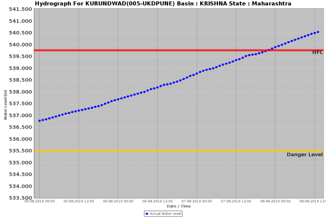


Unprecedented nature This has happened just over the last three days. It and this is pretty unusual as you do not see HFL crossing at so many places simultaneously. Moreover, normally when HFL is crossed, the new level is at the most a few centimeters higher than the previous HFL. In current floods, the new HFL is upto unbelievable 5 mts above the previous HFL at more than one place. Additionally, normally the water level crosses HFL for a few hours at the most. In current floods, the water level has so far remained above the previous HFL for over two days in some instances. EVERYONE of these parameters show how unprecedented the floods are. Higher the duration, amplitude and sites, implies higher the damage potential of the floods.
High Rainfall There has been above normal rainfall in Upper Krishan Basin in Maharashtra, which mainly includes districts of Kolhapur, Sangli and Satara. In these three districts, the rainfall, as per IMD’s figures, till 0830 am on Aug 8, 2019, have been 2068.5 mm (70% above normal), 480.7 mm (60% above normal) and 1028.1 mm (78% above normal). These districts have received rainfall much above rainfall during Aug 1-8, with rainfall of 716.6, 177.6 and 363.6 mm respective, the rainfall being about 400% above normal in this first week of August. But this is not such an unprecedented high rainfall that cannot be managed without allowing it to create a disaster that these districts are now facing. Moreover, the high rainfall was distributed over eight days and was preceded by warning of high rainfall.
Role of dams However, in the same period when these districts were getting high rainfall, the dams in these districts started releasing large quantities of water, which played a major role in creating the flood disaster. The dam operators are likely to turn around and say that but the dams were full and we had no option but to release water. The question is WHY WERE THE DAMS FULL when monsoon is just about halfway through and IMD has predicted much higher rainfall in the remaining part of the monsoon compared to the first half?
If we look at the graph below, we see that three of the big dams in this region, namely Koyna, Radhanagari and Warna were almost 100% full by Aug 5, when the current flood wave started. The flood disaster has exactly coincided with the dams getting full, that is from Aug 5, 2019. But why were the dams full by Aug 5, 2019? Why did the dams not start releasing water from say July 25, 2019, when Koyna and Warna dams were only around 50% full. The Radhanagri dam should have started releasing water even earlier as that dam was already close to 80% full by July 25. If these dams had started releasing water from July 25, 2019, they would have had sufficient space during the first week of Aug 2019, when the districts received heavy rainfall and that would have helped reduce the floods rather than increased it as the dams ended up doing.

Koyna dam, by far the largest of the Upper Krishna basin dams in Maharashtra, in fact, has FRL (Full Reservoir Level) of 657.9 m and live storage at FRL of 2652 MCM (Million Cubic Meters) as per CWC’s weekly reservoir level bulletin. However, as per Maharashtra Water Resources Department website, Koyna FRL is 659.43 m, and was already filled upto 658.65 m, with live storage of 2742 MCM, higher than its live storage capacity.
The story of other dams in the Krishna basin in Maharashtra is similar with Ujani (89.8%), Khadakwasla (95.73%), Dhom (88.43%), Dudhganga (89.28%) full as on Aug 6. In downstream Karnataka too story is similar with Ghataparabha (95%), Malprabha (92%), Almatti (70%). Almatti, fortunately has reduced the storage level from 85% on Aug 1 (why it filled up to 85% on Aug 1 is another question) to 70% by Aug 7.
This indicates that if Krishna basin were to get another week of high rainfall, the flood situation in the basin would get much worse than was the case either in Aug 2005 or in Oct 2009 (Andhra Pradesh). And the large dams, that are supposed to help moderate the floods, would again be major contributor to the flood disaster. As has happened in numerous occasions in the past too.
The role of dams in the current Krishna basin floods is also apparent from the statements of Karnataka and Maharashtra Chief Ministers. The Karnataka CM wrote to Maharashtra counterpart to convey that because of sudden release of large quantities of water from Koyna dam contributed to floods in North Karnataka. Maharashtra CM, in turn, called up Karnataka CM to request to reduce the water level of Almatti dam to reduce the backwater impact in upstream Maharashtra.
No Lessons from the past? In fact, Maharashtra had set up a committee after the Aug 2005 floods, but the report of that committee remains a state secret till date! That reflects a lot on amazing transparency in our water governance.
It may be recalled, that just weeks earlier, large parts of Maharashtra faced drought that many described as worst than the drought of 1972. Why is it that so soon after that the state is facing the worst floods of the century? We may choose to sweep this under the climate change carpet, and there is no doubt there is role of climate change in worsening our rainfall pattern.
But we may also understand and acknowledge that capacity of our catchment areas to hold, to absorb, store the rainwater and recharge the groundwater in a decentralised manner is reducing, thanks to our indiscriminate and mindless development pursuits. We need to really work to improve the capacity of the catchment to hold, store and absorb the rainwater and recharge the groundwater. This includes increasing the capacity of our soils to hold and store moisture and having sufficient local water harvesting systems, wetlands, forests and other groundwater recharging mechanisms. That would help reduce the flood peaks and also drought frequency and intensity.
However, immediately, we need to ensure that the water stored in the dams is judiciously released to make way for possibly high rainfall incidents in coming weeks. The rule curves of all the dams need to be put out in pubic domain and accountability fixed when the rule curves are violated.
Himanshu Thakkar and Parineeta Dandekar, SANDRP (ht.sandrp@gmail.com)

1. Why should dam/reservoir rule curves in India be a state secret? (Hope, reservoir rule Curves even exist for many of Indian dams)
2. Similarly, why should reservoir sedimentation and loss of live storage data be a state secret?
One of the causes of floods is the loss of storage in India due to aging dams of India.
Pl read “Aging large dams and future water crisis ” in EPW June 29, 2019.
LikeLike
Thanks, indeed Harsha, yes, agree with you.
Himanshu Thakkar
LikeLike
Nice study sir
Maharashtra and Karnataka govt must take simultaneously steps.
Dr.Ramesh Redekar….
LikeLike
There is no foresight at all to planning authority. It is being run by political parties. Every politician is safeguarding his own consitituency. Dams are built but distribution channels are yet to be constructed even after many years of construction of dams. Sedimentation of silt in reservoir of dam catchment area is unknown. Hence we don’t the know holding capacity of resirvoir of dams. there is regional authority’s who are managing the water resources to safeguard reginal interest witout considering overall impact on others.hence centralised authority is required to take care of worst condition without political influence.
LikeLike
Nice article. This calls for judicious dam water management, proper canals building from the reservoir & accurate meteorological prediction of rains in the regions concerned.
Regards
LikeLike
It would be interesting to know whether the CM and Irrigation ministers in both states were monitoring this situation during the last week of July or only woke up in August. Also what were the orders ( oral or written ) given to dam operators ref release given the depleted storages last year and the obsession with drought alleviation inspite of risking a disaster like this for the third time in 14 years. I live in Dattawad which is across the river from Sadalga, and now a veteran of these situations.
LikeLike
Thanks sir, Plz share your email address, would like to hear more from you.
LikeLike
Thanks for posting detailed analysis. While the rains have been way above average over the last couple of weeks, this is not a natural calamity but an artificial one. If not the floods, at least their effects could have been prevented.
I would like to make following points here, your response would be appreciated
– Preemptive discharge of water from dams based on forecasts is risky given the accuracy of present forecasts. It is easy to say so in hindsight but in case the forecasts go wrong, authorities will have tough time defending their actions.
– Can we have better short term forecasts of rise in water levels at dams based on live recording of rainfall in catchment area?
– Do we have detailed maps/data in public domain of affected areas as function of discharge from dams? Something like when Koyna discharges at X cusecs, what areas are going to flood.
– Is there any modelling of river basins, rainfall, discharge levels and flooding?
LikeLike
Thanks Good points. No, sir, we have fairly accurate short term forecasts that is sufficient warranty for action. If we do not have accurate information about rainfall in the catchment, than we do not have basic information required for dam management and it reflects badly about our state of water information. Indeed, inundation maps for specific releases and river flows is again basic requirements for forecasting, preparedness, rescue and relief. But unfortunately, they are not in public domain, as per CAG report in most cases they do not exist. Modelling is very much required and has to be dynamic, but we do not even have accurate river carrying capacity figures at different locations in public domain. Possibly does not exist in most cases.
LikeLike
This is a good article. Do we have a kind of rulebook or protocol for dam management in India, particularly in Maharashtra? Where can I find one? … Anil Shidore
LikeLike
There is rule curve for each dam, but not in public domain.
LikeLike
Sharing mail address as requested.
LikeLike
Dear Sir
Thank you for very informative article on the flood situation of Krishna river as on 8.8.19
Already a week passed , still heavy rains are continuting and inflows are raising daily to Almatti Dam.
I am a resident of Vijayawada city where river is flowing above prakasam barriage.
In view of above i wanted to go through the “Dishaster Management Report” of Almatti dam for which i am searching the net and I bounced with your article but could not find the report. Can you please help me in linking such report if at all it exits.
Regards
CMD MURTHY
LikeLike
Sorry, sir, we do not have the report.
LikeLike
In my honest opinion, I think Almatti Dam is not responsible for flood situation in Sangli Kolhapur region .
Is there any such technically fit study available in the issue ? There are many things which can neutralize this Almatti myth. How does the SANDRP look at this factor of ‘Almatti Dam causes flood in Sangli Kolhapur region’ ?
LikeLike
The backwater impact study of Almatti, if it is put in public domain, will show that Almatti does have an impact in upstream Maharashtra, the extent is a matter of study.
LikeLike