
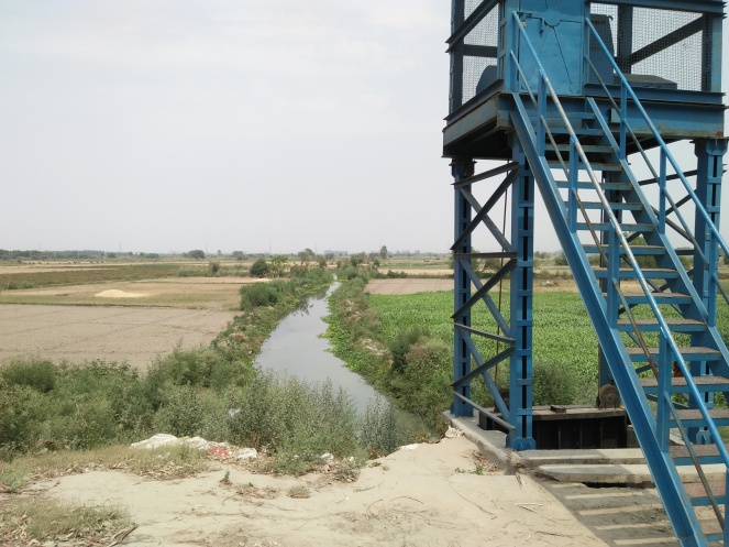
The stretch of Yamuna River & its floodplain lying between Palla and Wazirabad Barrage in Delhi is still in reasonably good state. Though bisected by an embankment, the floodplain is free of too many recent major encroachments. The River keeps meandering between physical boundaries of Delhi and Gaziabad district of Uttar Pradesh on the other side. The average width of floodplain from embankment to embankment is 2 kilometres. The width of active river current varies from 200-300 metres.
Most parts of the floodplain on both sides of this embankment are under agriculture. The crops grown here includes paddy, vegetables and floriculture as cash crops apart from wheat, traditional riverbed crops of melons, cucumber, tomato and bottle guards etc. Use of chemicals is also growing. There is not much information available about the impact of chemical farming on floodplain and river eco system.

The water quality in the river is apparently of bathing quality mostly when there is no industrial discharge in Drain Number 6 and 2 and Dhanaura Escape which carries massive effluents load from Sonipat, Panipat, Karnal and Yamuna Nagar districts of Haryana located along the river. These three drains originally flood escapes, more than often keep discharging industrial effluents in Yamuna. The stretch is also preserving some of the remaining riparian bio-diversity of plants, animals and birds.
The right marginal embankment (RME) construction started in 1976 two years before the historical 1978 floods. Delhi’s elderly say that in 1978 the flood water spread went beyond Grand Trunk (GT) Road at an approximate distance of 10 kilometres from river. The total length of the embankment is about 20 kilometres from Palla to Wazirabad barrage. Then there are more than two dozen shank branching off the main embankment, created to reduce flood velocity.
All the major human settlements like the villages Palla, Bakhtawar Pur, Mukmelpur, Tajpur, Ramzanpur, Akbarpur, Tiggipur, Usmanpur, Hiranki, Janghola etc. in Delhi are on right side of embankment, to escape flood damages.

On left side five big and several other rainy wells are located along this embankment. These rainy wells supplement Delhi’s potable water requirement of raw water. Although, most of the rainy wells are in dilapidated condition, many new are coming up to tap groundwater from the floodplain. A new water treatment plant is also being constructed and pipeline laying work is in progress there.

The Flood Control and Irrigation Department of Delhi Government has also built three flood monitoring sites at Palla, Janghola and Jagatpur with the objective to alert Delhi city about flood situation during monsoon. These sites are protected by shanks and RME. Recently three computerized gauge reading system have also been installed to improve flood forecast.

This is also the stretch proposed for water taxi project. In past, a seaplane project was also planned there. Currently some segments of embankment cum road are being turned into double lane to ease growing traffic movement. Sources also reveal that a new barrage project at Palla is in conceptual stage to replace aging Wazirabad barrage.

These projects will adversely affect the river ecosystem in multiple ways in years to come when they will be implemented. Considering the low water flow, the viability sea plane and water taxi projects is doubtful.
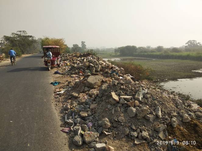
Apart from these looming threats, currently the floodplain in the stretch is facing abuse from encroachment and dumping of solid and liquid waste. The author visited the river length thrice in the months of May and June 2019, but saw the situation only turning worse. This account attempts to present a glimpse into to prevalent scenario.
Dumping of solid and liquid waste in Yamuna Floodplain

Industrial packaging waste dumped in Yamuna floodplain at Palla. Image 18 April 2019, Bhim Singh Rawat.

The dumping of industrial waste starts at the very entry point of the river into Delhi at shank number 1, Palla which as per locals is done by packaging and other industries located in Kundli, Sonipat. Kundli industrial are actually forms the border with Delhi state at Palla. A huge pit between embankment and road to Flood Monitoring Station Jhangola have been filled with solid waste.

The problem magnifies from the point the residential colonies of Burari starts. In the length of about 7 kilometres along the river between Salempur Mazra upto Wazirabad barrage area about a dozen colonies have come up in the Burari and Jagatpur village land over the years. The name of colonies is Upkar Colony, Bhagat Colony, Teachers Colony, Prem Nagar, Sant Nagar, Baba Colony, Dada Colony, Satya Vihar, Bengali Colony and Milan Vihar etc.
Slideshow of images showing solid waste dumping in Yamuna floodplain at multiple locations along RME. Images taken during 18 April, 11 May and 9 June 2019.
The part of floodplain along the embankment is filled with solid waste dump at multiple locations. At places it is defiling the water bodies filled with flood water. There are signs of the waste being burnt regularly.
Slideshow of images showing solid waste defiling water bodies, wetlands in Yamuna floodplain at multiple locations along RME. Images taken during 18 April, 11 May and 9 June 2019.
We can see municipality notice boards have been place at all these waste dump site warning people against throwing practices and monetary fine if caught. But notice boards have made hardly any difference in curbing the illegal practices.
As per local there is growing trend of visiting river during religious celebration lik Chhath, Navratri, Ganesh Chautarthi. As a result a lot of religious leftovers and idols are left on the banks polluting the river.
In addition to solid waste dumping, the untreated waste water from the villages including Nathu Pura and from most of colonies is entering the river Yamuna flood plain via a drain.
Dumping of construction debris and floodplain encroachment
There are sites at Milan Vihar and Jagatpur village where construction debris are also being dumped inside the floodplain. This is also encouraging encroachment of the floodplain land.


C&D waste being thrown in Yamuna floodplain along RME near Wazirabad. Part of Signature bridge can be seen in backdrop. Image taken during 18 April, 11 May, 9 June 2019, by Yayati Bhardwaj, Bhim Singh Rawat.


Also at places temples (e.g. the temple sitting close to river at Jagatpur village bund road) and other permanent structures are being built inside floodplain, against the rules.


A huge piece of Yamuna floodplain under grab at Jagatpur village. Image 18 April 2019, Bhim Singh Rawat.
Similarly a huge piece of Yamuna floodplain is under grab at Jagatpur village. Sources say a Baratghar is being built there. A small room, plantation work, demarcation of land with wire fence and installation of submersible has already taken place there.

In the name of flood protection work, bunds are being extended into river which is squeezing the space for flood water flow and may create problem during monsoon.
Levelling of Floodplain for Yamuna Bio Diversity Park Phase II
The levelling of floodplain land for second phase of Yamuna Bio Diversity (YBD) has taken place. This is changing the original form of floodplain and eating into space meant for flood water spread. It appears that a huge piece of floodplain has been separated from the river by creation of extended bunds and embankment.


Under YBD park phase II huge chunk of Yamuna floodplain is being earth filled. Image 18 April 2019, Bhim Singh Rawat.
While under first phase YBD has done remarkable work in restoring riverine vegetation, the earth work and bund creation bisecting floodplain from river for restoration purposes is neither desirable nor advisable. It would set bad precedent and encourage further abuse of floodplain by other government and private agencies.

Summing Up Yamuna river and its floodplain between Palla and Wazirabad are still ecologically rich and biologically diverse in comparison with the 22 kilometres stretch between Wazirabad and Okhala barrage. The water intensive, commercial and chemical farming activities going on there needs to be checked. The impact of embankment widening work into double lane road and construction of rainy wells, land levelling for YBD phase II on the river should be studied.
The stretch would also be under tremendous stress due to Palla barrage, sea plane and proposed water taxi project in future. However in present the prevalent practice of garbage, construction waste and untreated waste water dumping in the floodplain requires urgent attention from concerned government departments. At the same time the ongoing and existing encroachment of the floodplain land must be stopped.

We hope prompt action from all the respective government departments to address immediate causes ruining Yamuna river and its floodplain. We wish urban planners would chalk out sustainable floodplain management policy and plans which holistically look into the feasibility and demerits of Palla barrage, sea plane and Yamuna water taxi projects by treating the floodplain as living entity and integral part of river and not just a piece of land waiting to be developed.
Composed by Bhim Singh Rawat (ht.sandrp@gmail.com)
You may also like to see,
Exploring a Living stretch of Dying Yamuna at the threshold of Delhi

For the government and land mafia flood plain are just piece of land ,they start it with this only first the people starts dumping debris on it and then the government encroach it in terms to clean that area and then game of construction over land start.I wish more and more people sensitise over Yamuna destruction and come forward.
LikeLike