An abundance of a river and fast diminishing forests This photo-story chronicles the various moods of Lohit river from the point it enters India to the point where it is joined by two equally big rivers to form the mighty Brahmaputra. All photographs taken by Nivedita Khandekar during various journeys over the last decade, mostly in winters.
From references in Indian mythology to the location for proposed cascade of hydro-power projects, Lohit river of Arunachal Pradesh in north-eastern India is unique in many ways. It enters India at the juncture of Tibet, Myanmar and India at the easternmost point. It is as if this free-flowing, almost tempestuous river, cutting across the Himalayan hills, draws its tenacity from the people abounding its path. It would not be wrong to say that the unpretentious Meyor and the Mishmi communities lend their character to the river they call their own. After meandering through the Mishmi Hills, it traverses a short distance at the foothills as if freed from hilly prison only to assimilate its huge volume of waters with two other giant rivers to form the colossal Brahmaputra.
SANDRP map of Lohit Basin
In winters, the river becomes a calmer and beautiful version of its turbulent monsoon torrent. Even when there are roads till very near the border with Tibet, the journey along the river is through difficult terrain. The government has planned a cascade of 13 dams on the Lohit and its tributaries much to the chagrin of many locals and environmentalists from all over. The government has goofed up number of times when it comes to obtaining environmental and forest clearances. Fortunately, work has not started on any of the projects. May the river remain free flowing as it is today.
Lohit Basin map with location of proposed Hydropower projects (Source: Cumulative Impact Assessment)
According to the Cumulative Impact Assessment study of the Lohit river basin by WAPCOS India (Wapcos India is not known for doing credible reports on environmental aspects, but quoting here as it provides an over view of the Lohit Basin): “River Lohit is a tributary of river Brahmaputra and originates at an EL 6190 m above mean sea level from the snow clad peaks in Eastern Tibet and enters India through Kibithoo area of the district. River Lohit in the upper reaches is known’ as Krawnaon and after flowing westwards, joins tributary called Chalum Susning flowing from Indo-Burma Border. The combined flow is known as Tallow or Lohit river… Rivers Dau, Dalai and Tidding are its major tributaries on the right bank and river Lang is the major tributary on the left bank. It meets Noa- Dihing, Kamlang, Tabang and Tengapani River on the left bank and Digaru, Balijan and Kundli on the right bank. The catchment area of river Lohit including Tibet region is 29,487 sq km. The catchment area in Tibet has been estimated as about 15,034 sq km.”
Google Map showing the location of various places mentioned in the Photo EssayAnother Google Map showing more locations mentioned in the Lohit Basin Photo Essay
Here is just a glimpse of that fascinating ride along the free flowing river, from the point where it enters India, to the point where it becomes Brahmaputra and further downstream.
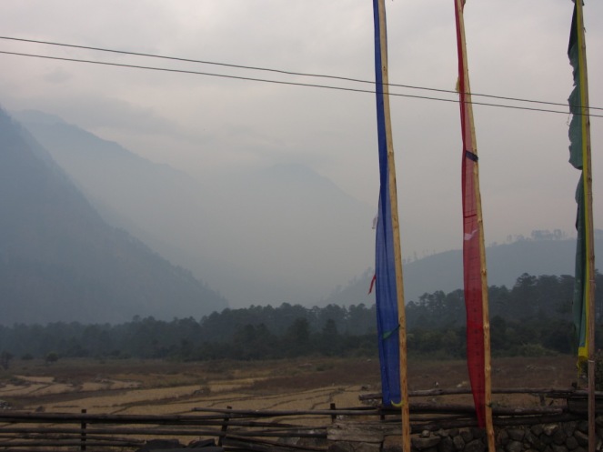
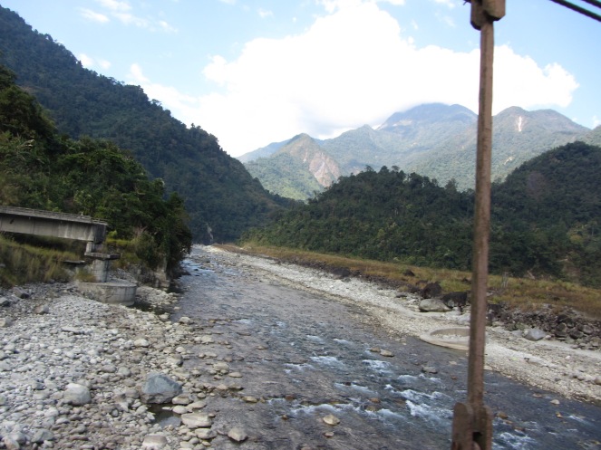
This is a view from a house at Kaho, the last village near the Indo-Tibetan border. Down below the tilled land (on the left) is the point where Lohit enters India at a point little north of Kaho (28°19’N, 97°00’E; c. 1327m asl). The two hills partly visible (on the left) are inside the Indian territory while the third almost entirely engulfed in the fog is part of the ridge that forms the McMohan Line that divides India and Tibet. (Photo: Nivedita Khandekar)Kaho and Meshai (also called Mosai) are the two small habitations of Meyor community on the left bank of Lohit in Kibithoo neighbourhood. Kaho has just seven houses. In absence of a road (which is on the right bank all through), this hanging bridge, about six kms from Kaho, is the only connection that the two bastis have with Kibithoo and hence, rest of India. Lohit flows through a gorge for a long distance in this stretch. The atmosphere is hazy in winters on most days. Similarly, the strong winds on most days exacerbated due to the gorge make it very hard for commuters crossing the hanging bridge. (Photo: Nivedita Khandekar)This was the only motorable road connection that the two bastis Kaho and Mosai had with Kibithoo. Built only in 2009 as suspension bridge by the Indian army, which touted it as the “Easternmost Road of India”, this bridge was washed away by Lohit’s perilous floods in 2012. People are left to use the hanging bridge again. (Photo: Nivedita Khandekar)As the blue river charts a serpentine path, the sparsely populated hills are covered with large coniferous trees as found in higher altitude. The Lohit is called Tallow in local Mishmi language. Beyond the human habitations around Walong area, there are large and small several lakes, some of them glacial lakes, at 6,000 feet and above. These lakes feed big and small streams and rivers joining the Lohit from both sides. In monsoon the river turns muddy and showcases an entire range of grey and ash. (Photo: Nivedita Khandekar)The difference in volume that the Lohit carries in winters and monsoon can be understood from the markings on the torn hill on the other side. The water column easily rises to almost 100 feet or more in peak monsoon and the winding river gnaws off hillocks and washes off soils and trees in its spate. In winters, icy cold water splashes the banks that are full of pebbles of various shapes and sizes. These pebbles form the core of building material for roads by the Border Road Organisation (BRO) that needs to bring tar / bitumen from outside Arunachal Pradesh. Locals in the higher reaches still majorly live in houses made of bamboo, so these pebbles hardly make to the civilian construction sites there. (Photo: Nivedita Khandekar)The site near Walong that has hot springs, aptly called Garam Pani. It is a typical Himalayan geological feature of warm water oozing out of a small opening barely metres away from the bone chilling cold waters of Lohit. This is a popular tourist destination for both locals and outsiders. In winters, as the Lohit waters ebb, the spot is open for all to reach easily. (Photo: Nivedita Khandekar)Places that are few and far on the left bank are connected with a variety of bridges – bamboo made, steel wire suspension bridges and at very few places, proper RCC bridges – with the road on the right bank. This one, a little downstream of the hot springs leads to Dong that receives the first sunrays of India. (Photo: Nivedita Khandekar)Walong, situated at a picturesque location at an undulating 4,500 to 6,000 feet, was where the Indian soldiers braved the Chinese onslaught during the 1962 war at the nearby Namti plains. Here the Lohit flows on one side of a vast relatively plain land form at about 4,500 plus altitude while the hilly road side has almost all the houses. There are war memorials (both old one and new one) and few government offices apart from the ALG (advanced landing ground) of the armed forces. (Photo: Nivedita Khandekar)
An emotional poem adorns the plaque at this war memorial. (Photo: Nivedita Khandekar)
This is a war memorial in the shape of Mishmi community’s memorial for the dead. A sentimental poem adorns the plaque at this war memorial. (Photo: Nivedita Khandekar)
This is a war memorial in the shape of Mishmi community’s memorial for the dead. An emotional poem adorns the plaque at this war memorial. (Photo: Nivedita Khandekar)
All the way downstream till Hayuliang is all pristine landscape. The free-flowing river makes for photogenic frames anywhere you look. The multitudes of shades of green around in winters makes one imagine what it might be in peak monsoon season. The changing vegetation is an indicator of the changing altitude as you travel down along the river that covers about 200 kms during its journey through Anjaw and Lohit districts till Parshuram Kund in Lohit. (Photo: Nivedita Khandekar)From Kibithoo till Hayuliang, the road runs parallel to the river and entirely on the right bank. At times, right near it, as can be seen here. At times, high above on the face of the lofty hills. Having a road connection makes or breaks the overall connectivity for the people and the army. In 1962, there was no road beyond Tezu, the headquarters of the then undivided Lohit district and Indian soldiers had walked almost 8-10 days to reach the respective posts near Walong and Kibithoo. Things are relatively easier now with the BRO building and maintaining roads but there is always a possibility of a landslide washing away a substantial chunk of the road and/or the hill on which that road is built. (Photo: Nivedita Khandekar)Hayuliang (seen on top left) is a scenic place at an altitude of about 4000 feet approximately almost mid-way between Tezu and Walong. As altitude decreases, alpine vegetation gives way to subtropical forests. These were some of the densest tropical jungles in all of India. But now, places such as Hayuliang and surrounding areas have become major concrete zone as scores of government offices shifted here in last decade. Also, it is a major congregation point for people coming from the Chhaglagam side, an area that is not entirely connected with motorable roads. Hayuliang showcases both the modern and the traditional facets of Mishmi community, especially its housing and food habits. (Photo: Nivedita Khandekar)That the Lohit flows with a mighty force in monsoon season is known. But how much force? So much so that it washes away even RCC pillars and bridges, both under-construction and old ones too. This picture near Hayuliang is looking from one hanging wire bridge to the terrifying remains of a swept away bridge from previous monsoon season. (Photo: Nivedita Khandekar)Apart from seven main tributaries, hundreds of such smaller rivulets join Lohit from both sides. This small one, from near Manthi basti near Wakro, remains a mere trickle in winters but flows almost wall to wall in monsoon. Some years witness its furious floods too. (Photo: Nivedita Khandekar)A beautiful, serene destination, Parshuram Kund is a major pilgrim place on the Lohit banks. A huge mela is held for two days on the occasion of Makar Sankranti in January every year. The story associated with the place goes that after killing his mother and brothers on the orders of his father, Parshuram could find no other place to wash off his sins. The kund here, now only a portion of it remains after the 1952 quake, was the place where the Parshu came off his blood-stained hands. Also, upstream of this place till Tiding inside the river waters is considered to be the sacred abode of Nimkay, the spirit that is invoked by the Mishmi community before their every ritual. (Photo: Nivedita Khandekar)The spot where Lohit emerges free from the mountains. A little upstream of this place is Parshuram Kund, a place squeezed tight between two virtually parallel mountain ranges. Downstream of this, on the right side, the road continues through the gradually decreasing slope towards Tezu while on the left side is jungles bringing in several more tributaries of Lohit. In winters, a whole lot of pebbled riverbed is exposed. At several places, this makes for an easy spot to collect pebbles and stones for crushers used for road building. (Photo: Nivedita Khandekar)An aerial view of the Lohit’s braided channels in winters soon after it emerges from the hills and simply spreads on the plains. The fantastic view right till the horizon makes for a good photo opportunity. At the same time, it also brings in a thought about the possible dreadful image of this whole place under thick volume of water in monsoon. (Photo: Nivedita Khandekar)This is the kind of ever green jungle that Lohit once had in the catchment in the plains. With a rich biodiversity, these jungles are home to several rare species of flora and fauna, comprising both identified and yet to be identified by scientific community. These jungles were home to orchids and medicinal plants. (Photo: Nivedita Khandekar)For about last five years, the thick forest is giving way to agriculture as need and greed of the increasing population increases exponentially. Plus, several of the farmers are shifting to commercial crops as against the traditional practice of subsistence farming. This spot near the road joining Wakro and Chongkham had till about four years ago forest so thick that nothing was visible from the road beyond 50-60 feet. But today stands a sorry picture of the forest turned into agriculture land. Road side land pieces have commercial crops such as tea and oranges in this area but deep inside, acres and acres of jungle is fell for poppy cultivation. (Photo: Nivedita Khandekar)Till about 6-8 years ago, central Lohit had no bridge and hence the main mode of transport was such a raft made from joining wooden boats to carry vehicles across. The army would also lay pontoon bridges for its heavy trucks, but most civilian vehicles preferred this arrangement of crossing the river – much tamed down compared to its roaring monsoon avataar. (Photo: Nivedita Khandekar)This is but a small glimpse of how the Lohit waters engulf every square inch of land and still spill over in monsoon. At times, the width of the single big channel that Lohit becomes spreads to few kilometres with the onlooker from one bank able to see only water till the horizon. (Photo: Nivedita Khandekar)A serendipitous scene of the bridge on the Noah-Dihing, a major tributary of the Lohit, now in Namsai district. When driving from Tinsukia in eastern Assam, Noah-Dihing is the first big river that a traveler encounters as he / she enters Arunachal Pradesh. This river did not have a bridge till about a decade ago and cause major connectivity issue in monsoon. The bridge, part of the series of bridges on the Lohit, has proved to be a big time boon to the locals as commuting has become a 24 X 7 X 365 days business unlike older times when monsoon means cutting off from rest of India for at least 8-10 days per season. (Photo: Nivedita Khandekar)
The 9 kms long Bhupen Hazarika Setu (bridge), inaugurated in 2017, connects Assam’s Dhola on the left bank with Sadia on the right bank of Lohit. This road that leads to Lower Dibang Valley and its headquarters Roing in Arunachal Pradesh and is useful for the people there as well as the army. (Photo: Nivedita Khandekar)
The chaporis are small sandy islands bang in the middle of the rivers with almost nil but distinct vegetation. Many people use it for farming even with the inherent risk of land erosion. This particular one is where the inhabitants have grown trees around in an attempt to protect themselves from complete erosion. (Photo: Nivedita Khandekar)
The 9 kms long Bhupen Hazarika Setu (bridge), inaugurated in 2017, connects Assam’s Dhola on the left bank with Sadia on the right bank of Lohit. This road that leads to Lower Dibang Valley and its headquarters Roing in Arunachal Pradesh and is useful for the people there as well as the army. (Photo: Nivedita Khandekar)
The 9 kms long Bhupen Hazarika Setu (bridge), inaugurated in 2017, connects Assam’s Dhola on the left bank with Sadia on the right bank of Lohit. This road that leads to Lower Dibang Valley and its headquarters Roing in Arunachal Pradesh and is useful for the people there as well as the army. (Photo: Nivedita Khandekar)
The 9 kms long Bhupen Hazarika Setu (bridge), inaugurated in 2017, connects Assam’s Dhola on the left bank with Sadia on the right bank of Lohit. This road that leads to Lower Dibang Valley and its headquarters Roing in Arunachal Pradesh and is useful for the people there as well as the army. (Photo: Nivedita Khandekar)
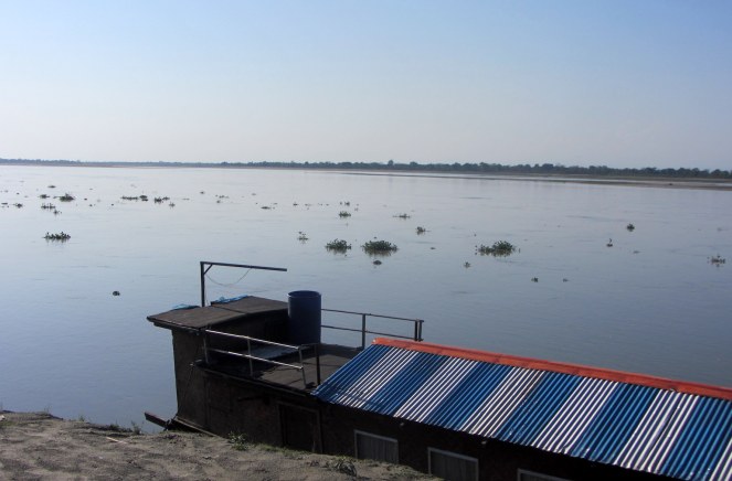
A tranquil evening at the spot where Lohit ends and Brahmaputra starts; the confluence of Lohit, Dibang and Siang. This is about 15 kms north of Tinsukia. This spot is famous for its Gangetic Dolphins and a variety of aquatic biodiversity. In winters, the Brahmaputra – it is ब्रह्मपुत्र and NOT ब्रह्मपुत्रा as the massive volume has made it a male river, a and नद, one of the only few in India – is nothing like its monsoon version, appearing restrained as against in full spate in June and July. Here the river is called the Burha Luit, signifying the ancientness of the river as burha means old. (Photo: Nivedita Khandekar)
Nivedita Khandekar is an independent journalist based in Delhi. She writes on environmental and developmental issues. She can be reached at nivedita_him@rediffmail.com or follow her on twitter at @nivedita_Him
3 thoughts on “Photo Journey along free flowing Lohit River in Arunachal Pradesh”
Dear Nivedita,
Thanks for visiting here. Your contribution in visual and literature kind will go down a long way while giving a socio-scientific face to the Mishmi Hills.
a native.


Dear Nivedita,
Thanks for visiting here. Your contribution in visual and literature kind will go down a long way while giving a socio-scientific face to the Mishmi Hills.
a native.
LikeLike
Many thanks,
On behalf of Nivedita.
LikeLike
3
LikeLike