
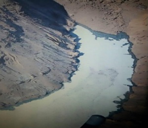
The picturesque Zanskar Valley in Jammu and Kashmir State in Northern India is under threat as one of the tributaries of the Zanskar River has been blocked by a massive 200 ft high landslide dam (equal to height of a 20 storey building). The landslide dam between Shaday Sumdo and MarShun in the Zanskar subdivision of Kargil district has created about 8 km long lake, whose size is increasing with every passing day. The landslide dam is made of mostly fine grained debris & blocks 97% of the flow of around 50 cusecs flow at this period as per records. While the lake is frozen right now, the threat of its breach looms as soon as the melting season starts. The landslide dam was reportedly created on Dec 31, 2014, when a whole side of mountain soil had landed on the Phuktal River. The landslide lake has been accumulating water for over a month now.
For Update dated Feb 13, 2015, see: https://sandrp.wordpress.com/2015/02/13/landslide-dam-blocks-phutkal-river-threatens-zanskar-valley-update/
For Update on Feb 21, 2015, see: https://sandrp.wordpress.com/2015/02/21/landslide-blockage-threat-in-zanskar-valley-to-continue-for-more-weeks-update-2/

This is the second such major event in Himalayas this year, the Sunkoshi landslide dam in Nepal happened earlier this year in August 2014[1]. The cause of the Zanskar valley event is not immediately known.
The location of the landslide dam[2] over fast flowing Tsarap or Phuktal River (a tributary of Lungnak River, which in turn is a major tributary of Zanskar River, which in turn is a tributary of Indus River) is near Marshun village, about 90 km from Padum, the sub-divisional headquarters of Zanskar, 43 km of that distance has to be trekked on foot. Sudden reduction of flow in the river at the downstream Nimo Bozgo Hydropower project of NHPC raised the suspicion of the landslide and this was ascertained only after a flight over the river path. The earliest news is dated January 17, 2015.[3] The reports indicated than that National Disaster Management Authority (NDMA) was immediately alerted then, but the NDMA team is yet to reach the location as per the latest reports[4] available.
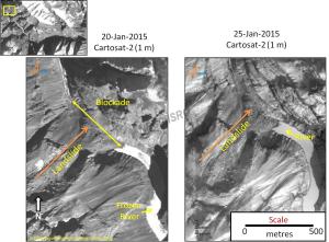
As of January 20, 2015[5], that dam was about 600 meters (2,000 feet) long, according to an analysis of satellite imagery collected by the Indian Space Research Organization’s CartoSat-2. The artificial lake that formed behind the dam was nearly 8 kilometers long and covered about 55 hectares.
Tourists from all over the world visit Ladakh to trek through famous 150 km long Chadar trek to Zanskar as well as people living along the Chadar trek from Leh to Zanskar use this route during Winter, due to blockage of Kargil Zanskar road in winter. The trek is famous for its breathtaking beauty. Chadar in Hindi means carpet and the term is used to convey that the frozen river in winter resembles a carpet.
“We had never before heard of a landslide of this magnitude hitting the region. It has almost completely blocked the fast-flowing tributary, which passes through a narrow gorge,” Skalzang Wangyal, executive councillor (tourism) in the Kargil Autonomous Hill Development Council told media[6]. Wangyal said the trek is opened by early January and operates until March. “This is the peak season but we had to close it for the safety of local people and tourists”.

What is the government doing The Kargil deputy commissioner said that they have done aerial survey of the area[7] more than once. On January 17, 2015, the Leh District Administration[8] notified, “It is being informed to the Tourists/Adventurers who are planning to undertake the famous Chadar Trek on river Zanskar, in Ladakh region, in the coming weeks that the District Administration has imposed a blanket ban on the trek with immediate effect due to sudden landslide in one of the tributaries of River Zanskar, thereby leading to a danger of flash floods.” This ban on trekking[9] triggered the major impact on the livelihood especially of porters.
The district administration also informed media that they stationed police personnel at Chilling and Nerak[10] and have started on January 25[11] air lifting of the stranded tourists.
After surveying the situation on January 18, 2015, a team of civilian and military engineers recommended that people who live downstream move to higher ground. They also discouraged authorities from using explosives to clear the blockage as doing so could trigger additional landslides. While the chance of a catastrophic flood is lower with the lake frozen, the risk will increase when temperatures rise in the spring.
Authorities have issued an advisory to the people living in four villages to vacate as there is a danger that artificial lake may submerge these areas. “A few villages in and around the Padum area have been given direction to move to higher areas. We don’t have any control over the situation. The NDMA will have to deal with the situation,” the Deputy Commissioner of Kargil Muhammad Sadiq Sheikh told media. “We cannot say off hand whether it is because of the global warming,” that assessment will have to wait, said the officials.
The administration is planning to establish a police detachment in Phuktal Gumpa to get regular updates about the situation in the area, but ensuring that the information from this monitoring station reaches the concerned people in administration and also those at risk will be a challenge considering the remote location.
The Government of India has constituted a committee of experts to assess the situation and formulate strategy to prevent damage to life and property. The Committee comprises of experts from the Central Water Commission, NHPC Ltd, Army, NDMA and the Indian Institute of Technology, Roorkee. The Governor of Jammu and Kashmir, NN Vohra, has also asked the National Disaster Management Authority (NDMA) to constitute a Multi-Disciplinary Expert Group with representatives drawn from NRSC, Central Water Commission, Geological Survey of India, Wadia Institute of Himalayan Geology and other concerned to evolve an Action Plan for dealing with the issue.

The Threat The local media is reporting about ‘grave situation’,[12] ‘imminent eco disaster’, “Environmental disaster unfolding in cold desert”[13] & ‘imminent catastrophic flashfloods’ in the Zanskar Valley[14]. The Member Parliament from Ladakh, Thupstan Chhewang said, “For past two weeks, I have been apprising the Ministry of Home Affairs about the imminent ecological catastrophe.” Chhewang said he has also requested the Defence Ministry to send its experts and a team of the Snow and Avalanche Study Establishment (under Defence Research & Development Organisation).
“Damming of Phutkal water course can result in destructive flashfloods in downstream habitations,” Prof. Shakil A Romshoo, Head of the Earth Sciences department at Kashmir University warned. Bursting of the accumulated soil due to land slide is also ruled out as the valley is narrow with 70 – 80 degree in gradation, which will further accumulate more soil and boulder.[15]
Water Spread is increasing NRSC (National Remote Sensing Centre) of ISRO (Indian Space Research Organisation) has started monitoring the situation[16]. As per the latest update on its website on January 30, 2015, the high resolution Cartosat-2 satellite data (1 m spatial resolution) of 25-January-2015 has been acquired by NRSC. As per this image, an increase in water spread is observed, the length of the water spread has hugely gone up, it is not clear if the width has also increased. NRSC has not quantified the increase from previous image of 20 January 2015.
Deputy Commissioner, Kargil, said that in case of the sudden bursting of the stored water from the artificial lake, a total of 29 villages and some bridges and other properties. in Kargil district would get affected.
Nimmo Bazgo HEP in line of possible flashfloods The 45 MW Nimmo Bazgo Hydropower Project of NHPC[17] on river Indus in Leh District also gets water from the River. It has a 57 m high Concrete Gravity Dam (the landslide dam blocking Phutkal river is higher than that), surface power house with 3 units of 15 MW each, 63 m long Head Race Tunnel & 35 m long tailpool & was commissioned on Oct 10, 2013. This dam near Alchi village also is one of the highest elevation hydel power projects in the world, located at over 10,000 feet above sea-level[18]. It has been generating below potential capacity for a number of reasons including lack of transmission lines and connected load within the region. The lean season generation was expected to be low (10.43 Million Units in January 2014 as per Central Electricity Authority figures[19], Dec 2014 generation from the project was 9.02 MU, marginally below 9.65 MU in corresponding month the previous year), and would have fallen further due to the landslide. The project is in the line of floods that the breach of landslide would create, but it is not clear if and what consequences the project may face.
Prof Dave Petley Considering the remoteness of the location, as noted geologist Prof Dave Petley of the University of East Anglia in the United Kingdom wrote in his first blog[20] on this landslide on January 19, 2015, “it will be extremely difficult to move sufficient resources to the site to manage the hazard.” His first estimate of the landslip volume, based on satellite pictures, is 2.7 Million Cubic meters, leading him to conclude, “This is quite a large landslide.”
In his post on January 22, 2015[21], Petley, based on images released by district administration concluded, “The landslide barrier appears to be tall but to have quite a narrow crest. Whilst there are many boulders in the debris, from these images there appears to be a great deal of fine-grained material as well. As an aside, the geological structure on the valley above seems to be quite unstable, with slope parallel discontinuities (bedding plans) that can act as detachment surfaces… there may be some seepage through the landslide mass occurring, given that there appears to be water in the Tsarap River channel (downstream of landslide dam). That water is not clean, which may suggest that there is some internal erosion occurring.”
Some recent events of similar nature In Aug 2010, the flashfloods triggered by a cloudburst in Leh caused massive damage to life and property. In January 2010[22], landslide dam in Attabad in Northern Pakistan led to death and destruction. In Sept 2014, Jammu and Kashmir also witnessed large scale destruction due to floods triggered by incessant rains. In Aug 2014, Sunkoshi sub-basin in Nepal saw massive landslide dam leading to death and destruction.
In Conclusion In his latest post (dated January 27, 2015[23]) Petley has warned: “I remain concerned that the material forming the dam is potentially erodible and that the dam crest is short, both of which suggest that there is the potential for a rapid breach event when the water overtops the barrier. There remains some urgency to get a monitoring system in place for this landslide, and then to start the detailed planning for what will happen when snow melt starts to fill the lake more rapidly.”
As we publish this in February 1, 2015, there are as yet no reports of NDMA team visiting the area, the NDMA website is totally silent on this issue, the Leh Administration that provided the first notice of the event on January 17, 2015 has no further update and it is not clear if the monitoring station has been put up with necessary communication system.
Shockingly, the national media is almost totally silent on this unfolding event in a picturesque remote corner of Ladakh (Kashmir) that could turn into a massive disaster.
We hope this situation improves soon and the issue is resolved with minimum damage.
SANDRP
PS: Its good to see the word spreading and media picking up the news, and giving it wider coverage. (For example: http://www.earlytimes.in/newsdet.aspx?q=141852 on Feb 1, 2015). If using information from this blog, kindly acknowledge the source.
2. The blog also features at: https://www.authintmail.com/2015/kashmir/landslide-dam-blocks-zanskar-river-tributary-threatens-valley-172856 on Feb 5, 2015
3. http://scroll.in/article/703953/landslide-blocks-zanskar-river-tributary-threatens-region on Feb 6, 2015
END NOTES
[1] https://sandrp.wordpress.com/2014/08/02/massive-landslide-blocks-sunkoshi-river-downstream-nepal-india-under-threat/
[2] The exact coordinates provided for the site are N 33° 17′ 25.3″ E 77° 17′ 06.8″ as per: https://www.facebook.com/notes/the-quint/disaster-looms-in-ladakh-but-is-anybody-listening/406548059512388
[3] http://www.kashmirlife.net/in-ladakh-chadar-trek-closed-for-tourists-71932/ dated Jan 18, 2015
[4] http://www.tribuneindia.com/news/community/j-k-artificial-lake-ndma-team-to-assess-threat/35844.html
[5] http://landsat.visibleearth.nasa.gov/view.php?id=85149
[6] http://www.telegraphindia.com/1150119/jsp/nation/story_9151.jsp#.VMyh-GiUfsF dated Jan 19, 2015
[7] http://www.sunday-guardian.com/news/governor-centre-strategise-to-save-zanskar-from-flash-floods dated Jan 24, 2015
[8] http://leh.nic.in/Minutes%20of%20meeting/CHADER%20Trek.pdf
[9] https://www.facebook.com/notes/sphere-india/situation-report-1-blockage-of-phuktal-river-due-to-landslide/719390981508834
[10] http://www.outdoorjournal.in/news-2/ban-on-ladakhs-chadar-ice-trek-after-landslide-blocks-river/ dated Jan 18, 2015
[11] http://www.dailyexcelsior.com/airlifting-people-stranded-zanskar-region-begins-2/
[12] http://www.tribuneindia.com/news/jammu-kashmir/lake-created-out-of-phuktal-river-poses-threat-in-kargil/32821.html
[13] http://www.dnaindia.com/india/report-environmental-disaster-unfolds-in-cold-desert-2053482
[14] http://www.greaterkashmir.com/news/2015/Jan/25/centre-wakes-up-to-imminent-eco-disaster-in-kargil-17.asp
[15] Sphere India SITUATION REPORT 1: BLOCKAGE OF PHUKTAL RIVER DUE TO LANDSLIDE dated Jan 21, 2015
[16] http://www.nrsc.gov.in/Phutkal.html
[17] http://www.nhpcindia.com/projectdetail.htm?CatId=1&ProjectId=39
[18] https://chandrashekharasandprints.wordpress.com/2012/11/16/filling-up-the-alchi-dam/
[19] http://cea.nic.in/monthly_gen.html
[20] http://blogs.agu.org/landslideblog/2015/01/19/zanskar-valley-1/
[21] http://blogs.agu.org/landslideblog/2015/01/22/tsarap-river-zanskar-1/
[22] http://www.landslideblog.org/2010/01/landslide-at-attabad-village-hunza.html
[23] http://blogs.agu.org/landslideblog/2015/01/27/tsarap-landslide-1/

Thank you SANDRP for the fantastic coverage of events such as these as they unfold. I have a couple of questions – which populated area is threatened due to this? Second, could you post a Google Maps link for the site of the landslide?
LikeLike
Hi Manu Sharma,
Many thanks for your feedback, this is very useful and encouraging indeed.
If you can enter coordinates mentioned in the blog (N 33° 17′ 25.3″ E 77° 17′ 06.8″) in Google Maps to find the exact spot.
NASA website also provides spot map, see: http://earthobservatory.nasa.gov/NaturalHazards/view.php?id=85149.
Two kinds of people are in the risk zone: One is habitations upstream of the landslide dam, along the river, that would face submergence as long as the reservoir size keeps growing, administration seems to say there are four villages here. Second is the set of habitations along the river in the downstream area that would face flashfloods and related disaster when the landslide dam breaches. The local government seems to suggest there are 29 villages here. However, we do not have more details of both classes.
Himanshu
LikeLike
Thank you, Himanshu for detailed response. Here’s Google Maps link for the coordinates.
Someone is quoted in the post saying that certain areas in Kargil district may be affected in the event of bursting of dam. I hope the Lahaul region is not affected in such an event, there are settlements along Keylong-Udaipur road that I’m concerned about but don’t know the terrain so well to be certain. Let’s hope the authorities control the situation before onset of summer by when it’s likely to get much worse.
LikeLike
A very professional and thorough report. Well done Himanshu ji. National media must pick this up and start to monitor it.
LikeLike
I had the privilege of working in this area of Phuktal Gompha and further downstream along Phuktal river and Lunek Chu in 1975. During summers these rivers are mighty roaring mass of water. But in winters, fortunately the streams are thin rivulets. The area is devoid of vegetation, as it is above the tree line and in that latitude even otherwise, nothing except few blades of grass grow. Landslides due to freezing and thawing action of water are common. All water that manages to reach the cracks and crevices of rocks during the day freezes by night. Next morning as the Sun shines the melt water in the cracks causes the rocks to burst. At times they burst with such a force that it sounds like gun fire. This leads to disturbance on the slopes and leads to landslides. Fortunately the area is sparsely populated and most of the villages are much above the river banks. Still if the water accumulated in the artificial lake thus formed is of great volume the result can be disastrous. In1897 when a similar landslide blocked Birehi Ganga at Gohna leading to formation of Gohna lake, it was estimated that the dam would burst by 26th Aug 1898. As per the calculation the dam did burst. But the ‘tyrannical’ British govt evacuated all low lying villages from Gohna to Rishikesh. Thus when the dam burst only five people died at Srinagar. Of course the loss of property was tremendous. Here the district magistrate’s statement that they can not do anything is not expected from a democratic govt. He can jolly well order all the 29 villages to be vacated and shift people to safer locations. The NDMA can at best make a recky and suggest means of controlled blasting to let the accumulated water flow out. Time is running short. Steps have to be taken before the onset of summers-these quiet streams will then become roaring monsters and even the hydroelectric project may be jeopardised.
LikeLiked by 1 person
Thanks Himanshu Bhai for this article. Plese follow what is happening there. It is astonishing that the NDMA team hase’t reached there yet and the media is silent about it.
LikeLike
It is indeed shocking that the media is silent on the impending danger and ‘disaster waiting to happen’ in the remote location in Ladakh.
LikeLike
We are pasting below a post about dealing with this situation from Sonam Wangchuk’s Facebook Page. Mr. Wangchuk is credited for setting up several ‘Ice Stupas’ in Ladakh to store water and address local needs.
FINDING A SOLUTION…
TO THE PROBLEM OF RIVER BLOCKAGE IN ZANGSKAR
Sonam Wangchuk
The recent blockage on a tributary of river Zangskar is a serious issue and if not cleared in time it will grow bigger and bigger as water collects to form an even bigger lake. The earlier we defuse this bomb the better.
This morning I spoke with the Executive Councilor from Zangskar and he briefed me about the situation there. He said that solutions by some experts as like airlifting a JCB excavator or bombing the landslide blockage do not seem feasible as the gorge is so narrow and there is danger of further slides if disturbed violently.
I have some experience in excavating earth without using heavy earth-movers. Some years ago I used this technique to dig a small passage/gorge from a plateau without hiring a JCB excavators. As they say in Hindi ‘Loha lohe ko kaat ta hai’ the idea is to use water itself to solve the problem of water. Strong jets of water from a fairly powerful pump can be used like water cannons to erode the loose soil that is blocking the river.
As we know water is a powerful cause of soil erosion anywhere. Well for a change, that destructive aspect of water could be used for a constructive purpose. So what I propose is that a helicopter should airlift one or two powerful portable agricultural pump sets, a few rolls of canvas pipes (fire brigade type) and… and me . With the jets of water the mound of loose soil can be washed down/eroded towards both the sides until the mound reaches within 7 meters of the water level of the lake. At this point, when suction is within atmospheric pressure range, you don’t even need pumps as natural siphoning system can work and the several big pipes can suck water out of the lake and continue the erosion process, just like we suck out water or kerosene from a barrel. For this you need non-collapsible pipes though. Once the water in the lake comes down to a non-dangerous level you can actually erode the rim of the lake itself to let the water out and let it erode its own banks and flow out till the bottom.
I have been preparing this technique for de-fusing the many dangerous high altitude glacial melt lakes that have formed all over the Himalayas and could burst into a flashfloods as happened in Gya village this year. But it’s good that this could be used for an even more urgent need on the Zangskar river. So those of you who are in contact with people exploring solutions to this problem may forward this post or ask them to get in touch with me. I see hardly any reason why this would not work.
But one thing is clear… Sooner the better.
LikeLiked by 1 person
nothing would happen and in future there will be a lake and hope fully a small water fall also.
LikeLike
Plz do something n open the river my friends home and field are in danger so plz sir do wat u can n open the river just like before……
LikeLike
Alex, it seems a channel has been opened over the landslide dam by combined efforts of Army, Air Force, Civil Administration and technical bodies, see: http://indiatoday.intoday.in/story/a-major-tragedy-averted-in-the-zanskar-valley-in-jammu-and-kashmir/1/426859.html
LikeLike