
 Days after walking down the Gori, we go to the Sub-Divisional Magistrate of Dharchula sub-division, Pramod Kumar, who is busy coordinating rescue and relief on a war-footing, but still has the courtesy to meet. On being asked by me regarding the sudden release of water by the 280 MW National Hydro-Power Corporation (NHPC) Dhauliganga Hydro-Electric Project (HEP, see below the layout of the project given on NHPC website) at Chirkila and the ensuing damage downstream, he confirms that he received an emergency call on the night of 16th June, 2013 from the NHPC, asking that they be permitted to release the impounded water in their reservoir, because it was in danger of breaching. Under normal circumstances they do not need his permission. He also confirms that he had refused, because the water level in the Mahakali main-stem was already flowing at danger-mark. NHPC went right ahead and opened their gates at full on the night of 16th June, without authorization or any prior warning to anybody[1] but their own office-residence complex 20 km downstream, at Dobat.

Source: NHPC
Was this really an emergency, or was this purely opportunistic on the part of NHPC to take this opportunity early in the season to flush their reservoir that had been filled almost to half with bed-load and silt? We went looking for clues and information. I went to the NHPC office complex at Dobat, and met Bhuvan Chand Joshi, their Public Relations Officer. After giving me the spiel on how safe, and how green this so called run-of-the-river (ROR) project was, constructed by no less than the Japanese, the Germans and the Koreans put together[2], he admitted that their underground power-station was entirely flooded. Housed in a gigantic underground cavern about 100 meters long, four-storeys high at 40 meters and about 16 meters wide, river water had filled it right upto the control-room on the fourth floor. I had already been told by Kesar Singh Dhami, taxi owner of Dharchula, that on the 16th June itself, when he was ferrying the first batch of Kailash yatris to the road-head on their way up to Tibet, he had noticed the reservoir was filled high already with flood-waters, with large uprooted trees and other woody debris floating at the damsite. He confirms that water was being released, but only a small release, despite the dam being fuller than he had ever seen it.
I was also told by another employee of NHPC (who did not wish to be named) that what had gone wrong was that despite the high flows on the 15th and 16th June, the power-station continued with production of electricity as usual. In what seems to be an unbelievably short-sighted and poor design, the Tail-race Tunnel, from where water is released back into the river after having turned the turbines, is flushed into a tributary stream, the Ellagad. It was when Ellagad also pulsed, that it sent a train of bed-load debris down its lower reaches, effectively blocking the exit of the Tail-race Tunnel coming out of the powerhouse. The power house continued to take in water from the Head-race Tunnel intake to work their turbines, unaware that the exit for water had been blocked. It is only when the water blocked in the Tail-race Tunnel surged back up, burst through the turbine units and began flooding the powerhouse, that NHPC even know that something was wrong. It was then that the massive curved steel gates of the intake were slid shut, and the powerhouse evacuated. This was further confirmed by Joshi, PRO, who also said that the ‘matter was under investigation’ by their own team for organizational detail. The General Manager and the Chief Engineer of the Dhauliganga HEP had meanwhile been transferred out. It is not clear yet how soon after the powerhouse was flooded, that they opened the sluice gates at the bottom of the reservoir. Draining it was clearly beneficial for NHPC, but catastrophic for roads, bridges and habitations downstream, both in India and Nepal.
If you look closely enough, there are two separate events here. The flooding of the powerhouse, and the ’emergency’ release of reservoir water. The powerhouse was not flooded because of too much water in the reservoir, but because it was in operation when its tail-race exit seven km downstream, is blocked-off because of poor short-sighted design[3]. They are then forced to close the gates of the intake, and abandon the powerhouse where water has reached the control-room on the fourth floor. The intake gates are now shut, but the flood waters continue to fill the reservoir further. They have already allowed the dam fill to a very high level, and here is the other curious factor.
The design of the Dhauliganga dam, is such that the dam has no provision for water to ‘overflow’ the dam safely, should undesired (even if foreseeable) levels be reached as they did this year. Or say if giant boulders block the narrow sluice gates at the bottom of the reservoir. Or in the real-time situation of what actually happened this year, the blocking of the tail-race tunnel leading to flooding of the powerhouse, hence requiring the shutting off of the intake, and losing the option of reducing reservoir levels more gradually and safely through two simultaneous releases. They then open the flood-gates. Clearly, one of two things have led to this decision:
One, letting the reservoir fill to a very high level is not out of the ordinary for NHPC; they do it every monsoon, as they had done on 16th June as well. It is not for many months in the year that they have enough water to run all four turbines. Despite the run-of-the-river label, Joshi confirmed that they were unable to let any water to continue to flow un-diverted in the river-channel during the winter-spring months (we have photographic evidence of this as well), or they would not have water to turn even one turbine! The mandatory requirement that every hydro-power dam in Uttarakhand be required to release at least 10% of the river’s minimum flows at all times (as greatly insufficient as such a small flow is for downstream life), it seems neither a consideration while justifying the economics of such projects, and neither is it complied to here. The use of the term run-of-the-river here, is plain deception.

Source: Author
Their regular annual schedule for flushing the reservoir of bed-load and sediment is normally the 15th of July and the 31st of July every year. Here again, when the reservoir is full, and there is enough water to provide the pressure for increased and accelerated flow to flush the reservoir on a twice-annual basis. Both flushing schedules follow each other closely at peak-flow season, so that the flushing is as complete as possible, and there is enough of a monsoon season ahead to fill the reservoir up again before the winter-lean. The probable reason for preponing the flushing could be the chance of flushing some of the unusually high accumulation of bed-load debris that had come down in this years flood. What this meant to the efficiency of the power-station is one thing, but what it means to all life in and along the river, is quite another.
Two, that the faulty design of the dam, both in location of its tail-race exit as well as no provision for over-topping, in combination with the carelessness of allowing the reservoir to fill to such levels at the start of the monsoon, was responsible for the ’emergency’ catastrophic release.

Source: Author
The Dhauliganga HEP is located on the Darma–yangti river, re-christened the Dhauliganga river, just a couple of kilometers upstream of the confluence with the Mahakali at Tawaghat. In these two kilometers, the rivers flows (twice a year when it is allowed to, for a few hours) down steeply to the confluence which it meets at right-angles. With the Mahakali already in spate, coupled with the sudden release of more than 6 million cubic meters of stored water (Gross Storage Capacity), plus the flow of the river in flood (steadily increasing from 398 cubic meters a second on 15th June), as well as millions of tonnes of bed-load boulders and sediment, the damage downstream is clear to see. If you look at the fresh scour-level on the banks downstream of the dam, it is in places more than 15 meters higher than the flood-level flow of the DhauliRiver. The river added thousands of tonnes of even more debris when, because of the flood level it reached, it tore through, plucking high at the talus-cones on either bank, and at every turn. At the confluence at Tawaghat, there must have been something of a back-flood for some time (a common flood phenomenon where the high-flowing main-stem creates a temporary water-dam), because the water-level seems to have risen very high, taking away the bridge that connects the entire Kuti valley and the trade route to Tibet, tearing away almost the entire village-market complex at Tawaghat, and destroying the road as well. The flood waters had clearly reached the top of the road because of the deposition of river-sand on it. When I walked this section days later, the river was only less than a meter below danger mark. Even so, it was flowing about 12 meters below the road! Further downstream, the destruction was more serious.
In order to understand the magnitude of this flood event, I ask Joshi of NHPC for flow-data of the Dhauli river between the 12th and the 18th of June. He goes off for some time and returns with a sheet of paper that has hand-scrawled 6 hourly flow volumes from 12th June, but stops short at 15th June. All the flow volumes between the 12th and the 15th were below 150 cubic meters a  second (cumecs), and at 12 am, on the night of the 15th June it jumps up to 389.92 cumecs. This is just the start of the flood. Joshi seems to balk right here, and says that they have not received data for the 16th June yet (the day I speak to him was the 8th of July), and that he may get it after a week or so. And anyway, he says, the powerhouse was abandoned from the night of the 16thJune, so getting data beyond that would be out of question. It is clear that Joshi was unwilling to give me flow-data for the duration of the flood-pulse. He had only minutes before informed me of how automated the whole operation was, and that it was possible for them to even operate the power-house sitting in their Dobat office-complex itself. The real scenario will be clear when we get flow data for the 16th and 17th of June.
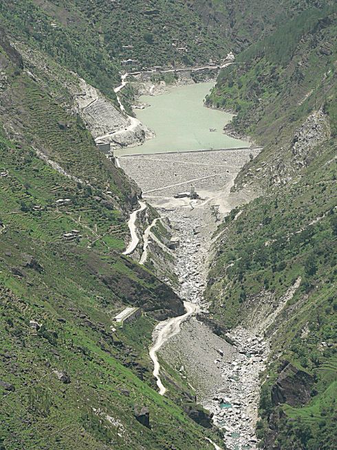
According to NHPC, the Peak Flood Design for the Dhauliganga HEP is 3,210 cumecs, at a return interval of 100 years. That is the flow volumes that the dam is designed to be able to take without damage, at flood levels expected at least every hundred years. It is unlikely that flow volumes had reached almost 10 times the flow volumes of the flood on the 15th June at the damsite (389.92 cumecs). NHPC gets its flow data from an automated level-gauge at the reservoir, so it did not require anyone to take readings manually, even prior to abandoning the station. If unprecedented levels had indeed been reached, then why had they held on to water in the reservoir right till the night of the 16th June? Please see the accompanying photographs, of the dam reservoir, empty of water. You can see at least two levels of cut-away terraces. The lower ones are alluvial terraces, consisting clearly of coarser gravels and cobbles deposited by the flowing river. The higher terraces, more visible high on the upper true-left bank in the photo, are remnant lacustrine (lake-bed) terraces, consisting of finer silts and sand, deposited by the stilled waters in the reservoir when it was full. This was the highest point of sediment accumulation in the reservoir prior to being flushed out. Clearly, at least 45% the reservoir was full of debris and sediment before NHPC flushed it. And if you look at the brown line on the concrete face of the dam, you see the level that the reservoir was allowed to fill upto, marked by the ‘bath-tub ring’ of floating bark and woody debris stuck there after draining.
Joshi tells me that when a delegation of people from Nepal came to NHPC to talk about the possible role that NHPC’s sudden release of water might have had on the flood that devastated Khalanga bazar at Darchula, he had told them that to the contrary, the dam had saved Nepal from great damage. “See how much debris is still behind our reservoir!” This was bare-faced misinformation. There are two aspects being denied here. One, that great masses of debris were actually flushed out from the lower-end of the reservoir on the night of 16th June, leading to greatly increased flood levels as well as erosive potential downstream, especially on the Nepal bank at Darchula, which bore the brunt of flushed debris centrifuged on the curve. As is evident from the photo of the dam-site above, most of the debris that has been flushed, is from the front-end of the reservoir only. And two, that all dams and reservoirs, despite some being able to flush out debris from a section of the reservoir, do actually hold back a great deal of bed-load as well as suspended sediment in the upper end of the reservoir. They impede the very essential flow of sediment down to the oceans. Look now at the geometry of bed-load debris in the stitched photo. Distortions from the wide-angle lens apart, it clearly shows a gradual slope, and a filling up of the bed-rock channel to form a wide, sloping flood-plain. Had it not been for the dam, the bed-load would have continued to fill up the bed-rock channel downstream at about the same angle, slowing the entire flow of water and entrained debris. It would not have been washed down catastrophically all the way down to Darchula, without the force of an additional 6 million m³ of stored water released suddenly.
Emmanuel Theophilus (etheophilus@gmail.com)
[1] NHPC never gives warning of sudden releases. There is a notice painted on a board at Tawaghat, the first river-side habitation downstream, that warns people not to go anywhere near the river, because water may be released anytime.
[2] Kajima Construction Corporation Ltd of Japan, Daewoo Engineering and Construction Company of Korea, and Bauer Maschinen of Germany.
[3] How a tail-race exit could be planned on the Ellagad stream which is very steep and unstable, full of debris from a service tunnel, and highly ‘flashy’, is indicative of poor design and of lax design approval mechanisms.

Reblogged this on Roshan's Blog ♥.
LikeLike
In have read the blog on Dhauliganga with interest. I will like to make following comments:
I was associated with the design of this project from 1998 to 2005. The project was approved during 1990 , but construction was from 1998 to 2005.
Regarding Location of TRT outlet in Elagad Nala, , this is release of waters from Dhauliganga river to Elegad (both Indian streams) as water could not be released to Kali, which is an international river. The release point is just upstream of confluence of Elagad with Kali. Agreed that nala is steep and brings a lot of material along with it during floods. But as engineers , we were ok with the situation.
Powerhouse flooding is perhaps due to non availability of additional redudant dewatering route of normal seepage from the access tunnel route. But this is perhaps the important lesson learnt for future rectification.
Regarding environmental flows from the dam, during 1990 and upto as late as 1998, we had no awareness or understanding about environmental flows. In fact , none of earlier projects has provision of release of environment flows. But I agree that existing projects should be made more and more environmentally sustainable,
Regarding design flood, no. 3210 cumecs represents Probable maximum flood , which is approximately equivalent to 1 in 1000 year flood . It is not 1 in 100 years flood. Maximum observed flood at this site is 1000 cumecs during 1995.
Regarding overflow spillway , we have a tunnel spillway at 1330 elevation . Normal practice to keep the water level at 1330 elevation during monsoon period with gate open. . Dhaulinga Reservoir is one of the smallest reservoir. I donot thick there is any difficulty to call this project as ROR. Depletion of reservoir during reservoir flushing is always a controlled operation releasing controlled discharges with inflow plus some thing extra.
We can further interact.
LikeLike
Dear Shri S C Mittal,
Many thanks for your detailed response and offer to interact further. I am sorry for the late response as I was travelling. In fact while on the move I did try to respond, but it got inadvertently deleted.
I would like to know further dimensions of the tunnel spillway at 1330 elevation, and with a gate that is kept open during monsoon. Can tell us all available technical details of this, including the size, capacity, etc? What was its design water release capacity?
Can you also tell us what modifications are possible inn the dam NOW for environmental flow releases?
You write: “Powerhouse flooding is perhaps due to non availability of additional redudant dewatering route of normal seepage from the access tunnel route.” However, what about the possibility of clogging of the outlet, which actually created the possibility of leakage/ seepage? Also what about the fact that the dam operators did not seem aware of the clogging till the TRC burst and backflow submerged the power house?
Please also let us know if you are associated with NHPC or some other organisations.
Thanking you for your response again, the author of the blog may have additional response.
Himanshu Thakkar
LikeLike
Thanks for seeking further response.
Let me first inform you my background with Hydropower sector. I was associated with NHPC from 1985 to 2007. From 2007 to 2012, I have been involved with Private sector in the field of engineering of hydropower projects only. Since 2012 onwards, we have our own hydropower engineering company and advise the hydropower sector in the field of engineering. My own specialisation is engineering of dams and spillways with interest in all areas of hydropower including its sustainable development.
Regarding tunnel spillway , the Tunnel spillway radial gate is 10 m x 10 m size aproximately. Since the discharging capacity is the function of head and gate opening at a given point of time, its discharge capacity will vary from zero to 800 cumecs approximately depending upon head and quantum of gate opening. . Its maximum capacity can thus be called as approximately as 800 cumecs. The gate is provided at MDDL level and normal practice is to keep the waterlevel in the small reservoirs at close to MDDL. during monsoon season. Under normal practice , with tunnel spillway gate open , the excess discharge into the reservoir is released from bottom outlets. The tunnel spillway acts as an additional safety device in this case which may not be necessarily required to be used.
For provision of environmental flows release from existing dams , there can be various possibilities. A small gated opening can be provided at minimum drawdown level (MDDL) in such a way that environment flow is available all the times , while reservoir level vary between MDDL and FRL. It is not such a big deal.
Regarding powerhouse flooding , my thoughts are that full blockade may not have happened. Flooding could have happened in this case even after normal precaution of machines closed and draft tube gates closed. But powerhouse operation is not from dam site. Dam site operators will have no role in powerhouse flooding or otherwise. It is upto the powerhouse to take water from the dam or not. intake gates of the HRT shall always remain open whether powerhouse is running or shutdown. Intakes gates are closed sometimes , when powerhouse is shut and reservoir flushing is carried out. But this is just a precaution.
Regards
LikeLike
Dear Mr. Mittal, Thank you for your inputs. They are indeed valuable coming from someone who helped design the Dhauliganga HEP.
1. Your infromation about a tunnel spillway at 1330 elevation is interesting. I have seen the dam closely and found no such spillway. If you give me your email id I will send you a photo of the dam gates at the bottom and the intake above the MDDL, and will request you to please point out where the tunnel spillway is?
2. Thanks for clairfying that 3210 cumecs is the PMF. You say that the max observed was 1000 cumecs in 1995. Could I ask how many years observation of flow volumes was your design flood based on, or was it an extrapolation of measurements at some other site downstream on the kali mainstem?
3. While the dhauliganga reservoir may be relatively small, The fact that it impounds water by a dam right across it, and does not leave any flow downstream of the dam for at least 6 months of the year, makes calling it an ROR project impossible, would you not agree?
I wait for you response and to interact further with you,
theo
LikeLike
. Thanks for seeking further information.
1. Regarding tunnel spillway location, it is on the right bank of course, just upstream of Power Intake. The tunnel spillway exits about 300 m downstream of dam axis, If you see the photographs uploaded by you closely, you can locate the tunnel spillway inlet upstream of the bend.
2. Probable maximum floods are not based on flood frequency criteria directly , but always arrived at by considering probable maximum precipitation in the catchment based upon most adverse combination of factors. Thus PMF represents the upper most value that could be possible at that site.
3. All ROR projects generally divert entire flow of the river through power tunnels. ROR means that downstream of powerhouse, during 24 hours, the volume of water released back to the river is the same as volume of water received in the reservoir upstream of dam.
4. we know that traditional designs donot consider flow into river downstream of dam upto powerhouse point.
Regards,
S C Mittal
LikeLike
Dear Mr. Mittal,
Thank you for your response. I am just about to travel for two days, and hence this quick response. I will send you a photo with more questions when I return.
My response and questions for now are:
1. When a dam does not have any water flowing from damsite to powerhouse because of diversion, that section is dry. A series of such projects would mean that long stretches of the river would be dry. This makes the notion of ROR quite meaningless in this context, is it not?
2. I would be very interested to know based on how many years data was the Dhauliganga Project PMF arrived at and designed? Was that PMF exceeded this year?
3. if it was not the blockage of the TRT, what could the possible cause of the flooding of the powerhouse be? I am not sure I understood what you said on this.
thanks a lot for your inputs
theo
LikeLike
My replies :
1. I believe ROR and environmental flows are two different issues. Your concern for environmental flows is genuine.
2. As Said earlier, PMF is estimated not based upon number of years of data but by following deterministic approach considering possible maximum precipitation in the catchment. IMD ( Indian Meterological department) gives the PMP values for different regions.
Normally , we should not expect more than one – third flood discharge of PMF during life time of a project.
3. Failure of dewatering system could have been another possible reason. Absence of alternative route to dewatering or its being non – functional could have been reason.
Regards,
S C Mittal
LikeLike
Energylineindia.com on Oct 13 2013
NHPC’s endeavour for restoration of Dhauliganga Power Station; agrees for modification in procedure
Oct 13: With an attempt to restore the normalcy at 280 MW Dhauliganga Power Station in Uttarakhand, NHPC Board of Directors discussed the proposal for modification in procedure for restoration of the Power Station in their 362nd Meeting held on September 17, 2013.
-In view of the urgent need of restoration of the Power Station, the Board has approved the proposal for modification tendering procedure and modification in Delegation of Power as given in the agenda note, till re-commissioning of all four units of the Power Station.
-The Board further authorized the CMD to issue necessary orders in this regard.
-Discussing the matter in its 362nd meeting, the Board noted that the proposed amendments include modification in tendering procedure, power to release interest free advance/down payment for the purchase of equipments etc. Moreover, the proposal has been recommended by the Management, the Board observed.
-Notably, the Dhauliganga power station in Uttarakhand has been stalled due to cloud burst and unprecedented high flood in Uttarakhand causing heavy damages to the plant and its infrastructure.
LikeLike